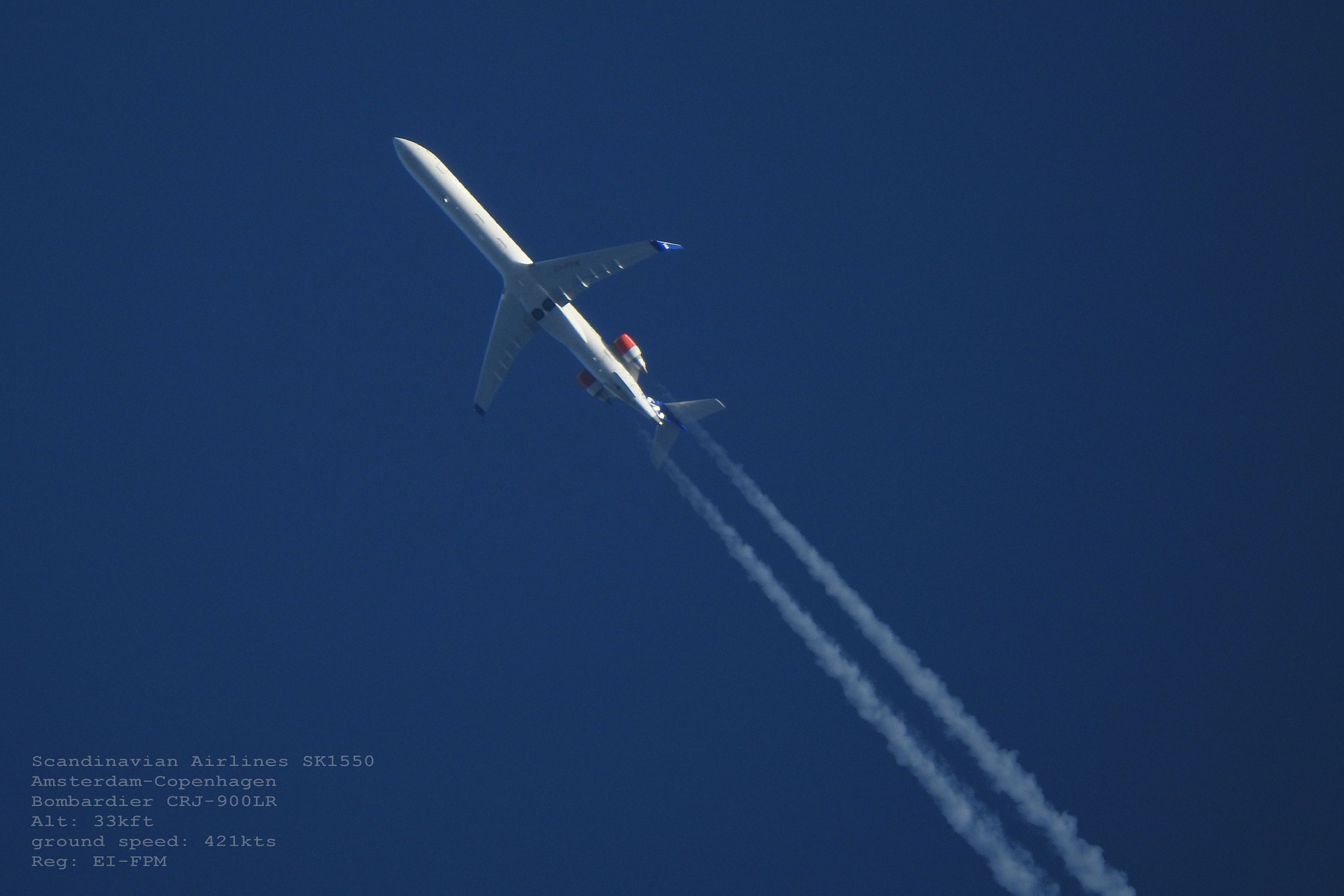
Cruising Altitude: How Low Is Too Low? (original) (raw)
 Credit: Photo: Cgrant573 | Shutterstock, Simple Flying

Published Feb 17, 2025, 5:00 AM EST
Luke Diaz is a freelance military writer with experience with active duty experience in the US Navy as well as defense and industrial engineering. He is a former Naval Flight Officer who performed tactical air control on the carrier-based E-2 Hawkeye.
Sign in to your Simple Flying account
Commercial aircraft operate at a range of altitudes on any given flight for reasons driven by aerodynamics, weather factors, airspace rules, or travel distance and fuel management - the list goes on.
The cruising altitude of a flight is a critical variable for the plane, the crew, and the passengers on board. There are various trade-offs between flying lower or climbing higher. In general, commercial flights typically prefer a flight level between 30,000 feet (9,144 m) and 42,000 feet (12,802 m) due to thinner air that improves efficiency.
In some cases, however, the aircrew, air traffic control (ATC) or airline may decide to go lower. Lower altitudes, between 10,000 ft (3,048 m) to 25,000 ft (7,620 m) can sometimes be a better choice under certain conditions or when flight plans make a high cruising altitude undesirable.
When lower altitude is best
Operational data from short-haul domestic routes shows that many commuter flights stay at lower altitudes to reduce climb and descent times. Cruising too high for a brief journey may offer minimal net benefit because the aircraft spends a large portion of flight time climbing.

Photo: K Bahr | Flickr
Descending to altitudes around 19,000 feet (5,791.2 m) or lower can mitigate severe turbulence or jet stream interference. Controllers also sometimes assign such altitudes to maintain spacing and avoid weather systems.
Dense air at lower altitudes penalizes fuel efficiency, but it can shorten flight time if tailwinds are more favorable. Safety is always paramount, and the pilot’s situational awareness includes data on in-flight icing, storm formation, or potential wind shear—sometimes deviating for any of those reasons.
Flight planning
Pilots and Airlines conduct extensive preflight planning before the plane ever leaves the gate. General weather conditions, winds aloft forecasts, and air traffic along the route are all important aspects of a journey. Plane performance limits vary with aircraft design, weight, and flight conditions.
Higher is usually best because jet aircraft exploit the thinner air for superior fuel efficiency. Naturally factors like engine performance, aerodynamic design, and weight constraints all apply when deciding how high to go.
This article from Boldmethod online aviation training includes a good step-by-step outline of how to plan for a cross-country flight in general aviation, and commercial flights use the same principles.
On most flights, you will be faced with at least some weather and the conditions aren't always ideal. That's how METARs, TAFs, and PIREPs help - when pilots see the clouds report, they think about coverage and altitude.
Challenges differ when crossing landmasses with mountainous terrain, where airflow is different and changes the ideal flight level for cruising. In regions with less air traffic density, flights can more freely operate at or near optimum altitudes.

Photo: K Bahr | Flickr
International long-haul flights rely on higher altitudes to cut transit times and reduce costs. Transoceanic routes utilize the North Atlantic Tracks or Pacific tracks, which shift daily based on prevailing winds.
Any source will tell you, like AN Aviation Services, that pilots carefully select the cruising altitude to minimize fuel consumption and take advantage of favorable winds but they have to be aware of their upper limits as well. As Simple Flying previously wrote on the topic,
“Flying at high altitudes poses difficulties for commercial aircraft , especially if they are near their maximum altitude of about 41,000 feet. At this height, the aircraft risks experiencing low-speed stalls and high-speed buffeting...”
Pilots on shorter flights frequently avoid high altitudes due to factors like climb rate versus distance and possible turbulence layers when selecting final cruise levels. Below is a list of common altitude ranges by aircraft type:
- Typical cruising range for commercial aircraft : 30,000 ft (9,144 m) to 42,000 ft (12,802 m)
- Common service ceiling for many jet airliners : 45,000 ft (13,716 m)
- Typical private jets ceiling: 41,000 ft (12,497.8 m) to 51,000 ft (15,544.8 m)
- Short-haul commercial flights : 10,000 ft (3,048 m) to 25,000 ft (7,620 m)

Photo: FAA
The role of turbulence and weather systems
Turbulence can manifest at any altitude, although it is often milder at higher levels due to stable atmospheric layers. Weaker winds and fewer weather cells above 30,000 feet (9,144 m) make the cruise phase smoother most of the time.
When meteorological data suggests severe turbulence aloft, lower cruising altitudes might be preferred depending on the type and severity.
The US National Weather Service describes all the known types of turbulence. Two major types of turbulence that cause aircraft to change their altitude, either higher or lower, are clear air turbulence and mountain waves.
Mountain waves are turbulent eddies that are found downwind from mountain ridges. They are caused by mountains and, therefore, remain localized to the mountain area. Mountain waves produce some of the most severe turbulence and have caused fatal plane crashes.
Because of the risk associated with mountain waves, aircraft need to stay well above the mountains. However, at higher altitudes, invisible turbulence with varying severity can also occur. One of the biggest problems is clear air turbulence, which is not indicated by clouds like other forms of turbulence.
General characteristics of clear air turbulence include:
- Occurs in patches
- Area is elongated with the wind
- Usually found above 15,000 feet
- In association with a marked change in speeds
- 2,000 feet deep
- 20 miles wide
- 50 miles long
- transitory
- Most frequent during winter
- Least frequent during summer
In areas where thunderstorms are common, there can be a high frequency of turbulent air patches, even at distances from the storm area. As the Aircraft Owners and Pilots Association (AOPA) reports on the subject:
"Thunderstorms have been known to produce extreme turbulence as far as 20 nautical miles from the parent storm. Request a wide deviation from air traffic control to give yourself and your passengers some added protection."
 Benefits of different cruise levels
Busy corridors near major airports may impose additional constraints, forcing pilots to level off at altitudes that differ from the aircraft’s best operating range. Controllers also separate aircraft moving in opposite directions by assigning even and odd altitudes.
The lowest usable flight level is determined by the atmospheric pressure in the area of operation, according to AIM Chapter 7, Section 2. The Federal Aviation Regulations ( FAR ) 91.159 states that over 3,000 AGL, separation of altitude puts some planes on odd-thousand MSL altitude +500 feet when flying magnetic headings between 0-179 degrees. Alternatively, flying a magnetic course of 180-359 comes with an assignment to an even-thousand altitude of +500 feet.
In simple terms, pilots use this saying to remember the rules: "East is odd, West is even."
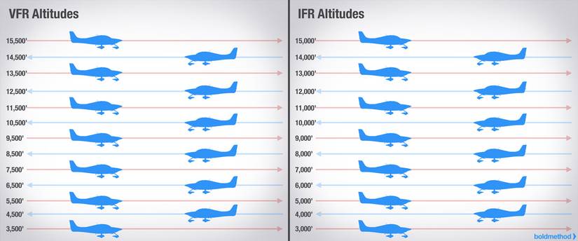
Photo: Boldmethod
Pressure decreases with altitude, providing fuel savings by reducing drag. This allows planes to travel farther on less fuel and achieve faster true airspeeds. Greater distance between the aircraft and ground-based weather phenomena (including mountainous terrain) adds an extra safety buffer.

Photo: FAA
Lower altitudes, however, become preferable if en-route icing or thunderstorms are more pronounced above 30,000 feet (9,144 m). Some general aviation pilots choose altitudes closer to 10,000 feet (3,048 m) to circumvent extended oxygen mask usage.
Public data indicates that cruising altitude is the phase in which an aircraft remains at a constant height for the majority of a flight. Global regulations and air traffic control stipulate semi-rigid guidelines for altitude selection, ensuring vertical separation.
Turbulence, weather patterns, aerodynamic performance, and engine efficiency all intersect in shaping altitude choice. Many commercial airlines opt for altitudes in the 30,000–40,000 feet (9,144–12,192 m) band to optimize speed and fuel use.
 Related
How Delta Has Gained From Its Focus On A Fuel Efficient Fleet
Delta Air Lines' cost per available seat mile (CASM) has also trended downward in the past three years.
Bottom line
Evolution in jet engine technology has pushed typical cruising levels higher over the decades. The increasing prevalence of heavy air traffic near major hubs triggers new research into more efficient high-altitude corridors and next-generation engine designs.
Fuel expenses are always the most significant operating costs for airlines. Cruising just a few thousand feet below an aircraft’s optimal level can increase consumption. Aircraft dispatchers and airline operations centers constantly recalculate using real-time flight data.
As Travel and Leisure, an online journal, wrote on the topic - “if the pilots in one aircraft report turbulence at a specific altitude, those flying behind that plane may adjust their altitude to "find clear air," as you might hear over the loudspeaker.”
The flight crew’s real-time data from weather radar on board, combined with reports from preceding aircraft and air traffic advisories, all combine to inform these decisions. Strategies include climbing above cumulonimbus clouds or descending to a stable layer if high-altitude weather is rough. As one pilot wrote to AOPA,
"In high-altitude cruise, jets must contend with the jet stream, shear lines, and of course thunderstorms that can top out way above my Boeing 737’s 41,000-foot ceiling. All these events will likely bring on the bumps, most assuredly tangling with a thunderstorm. Those are relatively easy to deal with since we have excellent on-board weather radar at our disposal."
According to one pilot in this TikTok, “I had to fly at 19,000 feet from ATL to RSW to avoid the worst turbulence.” Experienced aviators weigh these trade-offs, understanding that descending increases fuel burn but may be necessary to evade unpleasant or unsafe flight conditions.
Ultimately, the final altitude that your flight will take is a combination of judgment from ATC and the pilots at the controls as they consider the many variables at hand. Between air traffic and weather conditions, no day is the same, but thanks to technology, teamwork, and highly trained, skilled professionals, flying the friendly skies is safer and smoother than ever.
 Related
The 10 Airline Routes Most Likely To Experience Turbulence
While airlines take precautions to avoid and manage it, turbulence can pose a risk to passengers and crew. Due to a combination of factors, including topography, jet streams, and storm activity, some of the world's airline routes are more likely to experience turbulence events. The website Turbli tracks turbulence data and uses it to rank routes and airports. It measures turbulence in units of eddy dissipation rate (edr), representing "the speed at which turbulent structures break down and dissipate their energy into heat." The measures Turbli uses are 0-20 light for light turbulence, 20-40 moderate, 40-60 strong, 60-80 severe, and 80-100 for extreme turbulence. Based on a year's worth of data, the annual rankings show the average edr over that time frame. The routes with the highest average turbulence in 2024 globally were: 1. Mendoza (MDZ) - Santiago (SCL) with an average edr of 24.684 2. Cordoba (COR) - Santiago (SCL) edr 20.214 3. Mendoza (MDZ) - Salta (SLA) edr 19.825 4.