Hurricane Sandy: Four Years Later, A Meteorological Memoir | The Weather Channel (original) (raw)
Latest Hurricane News
By Jonathan Belles
October 30, 2016
- Sandy is known for its immense size, surge, wind, and snowfall impacts, some being felt four years later.
- Hurricane Sandy changed how the NHC produced it's forecast at the end of a storm's life cycle.
It has now been more than four years since Hurricane Sandy roared to the coasts of Jamaica, Cuba, the Bahamas, and the United States.
(MORE: Some Towns Still Wrestling With Consequences from Superstorm Sandy)
Here's a look back at the meteorological history of Hurricane Sandy:
Notable Stats:
- Highest Storm Surge: 12.65 feet at King's Point, New York
- Most Inundation: 9.56 feet at Bergen Point West Reach, New York
- Maximum Sustained Winds: 115 mph (near Cuba on Oct. 25)
- Minimum Central Pressure: 940 mb (near the New Jersey coast on Oct. 29)
- Most Rainfall (U.S.): 12.83 inches in Bellevue, Maryland
- Most Snowfall: 36 inches near Richwood, West Virginia and on Wolf Laurel Mountain, North Carolina
- Tornadoes: 1 F-0 tornado in Somerset, Bermuda
Meteorological History:
Hurricane Sandy, although known for its impacts along the Eastern Seaboard, attained peak strength in the Caribbean as a Category 3 Hurricane near Cuba early on October 25, 2012 with maximum sustained winds of 115 mph.

Track history for Hurricane Sandy
Sandy developed in the southwestern Caribbean Sea on Oct. 22, 2012 from a pre-existing African Easterly Wave (or tropical wave).
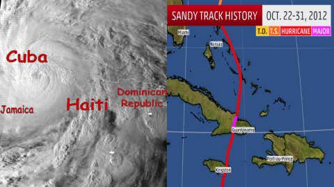
After a small counter-clockwise loop, a southward dip in the jet stream picked Sandy up and brought it northward toward Jamaica and Cuba. Intensifying as it gained latitude, Sandy quickly became a hurricane and for a short time gained Category 3 status just west of Guantanamo Bay and Santiago de Cuba, Cuba.

Left: Satellite image from early in the morning on October 25, 2012 as Sandy made landfall in Cuba. (Credit: NASA) Right: Caribbean track history for Hurricane Sandy
Although Sandy's center only spent five hours crossing Cuba, it would never have maximum sustained wind speeds over 100 mph again. Higher wind shear caused Sandy to gradually weaken as the hurricane moved northwestward through the Bahamas.
The tropical storm force wind field doubled in size in just under 48 hours as Sandy moved north of the Bahamas, a transition that had had ramifications for the rest of its life. Specifically, the growing wind field contributed to the damaging storm surge that would be seen in the Northeast.
An anomalous atmospheric road block located in the North Atlantic forced Sandy to then turn toward the northwest on a path towards the Northeast U.S. coastline.
Sandy strengthened again as it closed in on the Northeast, with maximum sustained wind speeds reaching 100 mph more than 200 miles southeast of Atlantic City, New Jersey, on Oct. 29.
Just prior to landfall, Sandy's tropical storm force wind field grew to at least 870 miles in diameter, a record size for a tropical cyclone dating back to at least 1988, and likely beyond.
Cooler water closer to shore created a weakening trend on approach to the Jersey shore. As Sandy approached the coast, cooler air wrapped around the western side of the circulation, causing snowy conditions over the central Appalachians. Snow in itself is rare in hurricanes, but this was just the beginning of a second transition.

Track history for Sandy, tropical (red/orange) and post-tropical portions included (yellow)
Just before making landfall on the New Jersey coast, observations pointed that this transition to "Post-Tropical Cyclone" had become final.
In essence, Sandy's core cooled, and its energy was being drawn more from aloft than from the ocean. Impacts along the coast and points inland remained unchanged, and Sandy began to weaken after landfall. Sandy crossed southern and western Pennsylvania and the circulation became ill-defined over northeastern Ohio.
Sandy gave up the ghost on Halloween in eastern Canada with one heck of a story to tell.
Sandy Rule
Following Sandy's untimely transition from hurricane to post-tropical just prior to landfall, lessons learned from confusion in the media and general public led the National Hurricane Center (NHC) to change some of their practices. This important new precedent based on a meteorological transition became known as the "Sandy Rule."
The Sandy Rule allows the NHC to retain control of tropical watches and warnings and allows the NHC to continue to forecast the future track and intensity of the post-tropical storm or hurricane.
This rule was notably invoked in Hurricanes Arthur of 2014 and Hermine of 2016.
MORE FROM WEATHER.COM: Hurricane Sandy

In this Tuesday, Oct. 25, 2016 photo, a flock of Canada geese waddle past houses slated for demolition on an abandoned street in the Oakwood neighborhood of Staten Island, in New York. Nearly four years ago Superstorm Sandy's deadly floodwaters coursed through the streets. (AP Photo/Kathy Willens)