Assessing social vulnerability of villages in Mt. Kasigau area, Kenya, using the analytical hierarchy process (original) (raw)
Abstract
This research assesses the social vulnerability of five villages (Jora, Kiteghe, Makwasinyi, Bungule, and Rukanga) in Mt. Kasigau, Kenya. Our goal was to develop a social vulnerability model by adopting a vulnerability conceptual framework that conceptualizes vulnerability into three major components: exposure, sensitivity, and adaptive capacity and using the analytical hierarchy process (AHP). Employing the AHP, the three components of vulnerability were decomposed into its constituent components and structured into a hierarchical format where each component was represented by different societal and environmental criterions and stressors. Next, we performed a pairwise comparison at each level of the hierarchy to obtain local priorities. Finally, we aggregated the local priorities from the bottom up to obtain global priorities of the social vulnerability of each village. The results from this study revealed that Makwasinyi was the most vulnerable village followed by Bungule, Kiteghe, Jora, and Rukanga respectively. Further, the results suggested that adaptive capacity and exposure played a critical role in determining the social vulnerability compared to sensitivity. Considering this, reducing social vulnerability in the area should focus much on improving the adaptive capacity of the people and reducing their exposure specifically in Makwasinyi village.
Figures (7)
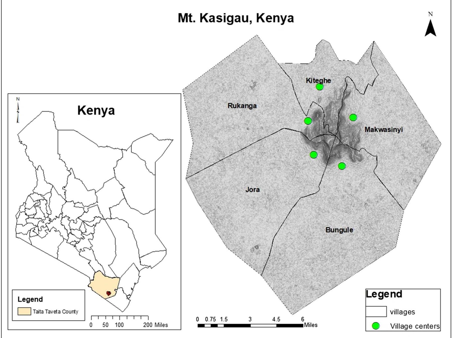
Fig. 1 Location of the five study villages at Mt. Kasigau, Kenya (Kalibo and Medley 2007; Leiter et al. 2013; Medley and Kalibo 2007). According to the 2009 Kenya population census report, there were a total of 9721 people in 1803 households in the five study villages (GOK 2010). A section of the local people engages in small businesses, while others have joined formal employment locally or in other parts of the country. According to interviews carried out with the residents, the Wakasigau almost lost their ancestral land during the First World War (Kamau 2017). They were accused by the British colonial administration of collaborating with the Germans which led them to be violently removed from their ancestral land to a coastal town known as Malindi from about 1912-1936 (Kamau 2017; Medley and Kalibo 2007). Later, they were allowed to return to Mt. Kasigau, in 1937, after Christian missionaries petitioned the colonial govern- ment to let them return to their land (Kamau 2017). vegetation within the plains is mainly composed of acacia bushland and supports a variety of wildlife including elephants, lions, zebras, giraffes, ostriches, and antelopes. Most of the bushland that surrounds the settlement at the foot of the mountain has been converted into farmland, making some of the wild animals migrate deeper into the bushland or nearby parks and communal ranches.

Fig. 2. Field work data collection framework starting from observation, focus group discussion session where the impact tree diagrams were constructed, and the semi-structured interviews used for data triangulation Observation, consisted of holding in-depth conversa- tions with non-governmental organization officials, village elders, and random village residents to gather background information of each village and under- stand threats that the residents of these villages encountered in their daily lives. We used observation, before, during, and after undertaking other qualitative methods. The aim of using observation at the start of the fieldwork was to gather background information of the villages and evidence of social vulnerability. Observation was also used to collect supplementary evidence that would add value to the other methods (Humphrey and Lee 2008; Kearns 2010). Data collected during our conversations formed the basis In this study, a group of 78 residents from the five villages were invited to help in acquiring data used for this research. We used purposeful, snowballing, and criterion sampling techniques to select the partici- pants. Baxter (2010), describes purposeful sampling as a strategy of finding participants who are rich in information related to the phenomenon of interest, whereas criterion sampling consists of selecting

Fig. 3. An example of one threat of social vulnerability (e.g., food security) extracted from an impact tree diagram developed in one of the study villages starting from the threat at the top up to the indirect causes of the threat at the bottom

Fig. 4 The analytical hierarchy model developed for examining the social vulnerability of the five villages at Mt. Kasigau Kenya

Table 1 The fundamental scale of measurement in AHP adapted from Saaty (2008) Results

Ranking the social vulnerabilities of the villages from the most to least vulnerable Fig. 5 A graphical representation highlighting the social vulnerability ranking of the five villages at Mt. Kasigau, Keny: The vulnerability scores (i.e. global weights) as highlighted in Fig. 5 reflect the order of ranking of thace inllagac fram the mact «wilnarahla tn tha: laact

Fig. 6 Global weights/vulnerability scores of the three components of vulnerability in each village
Key takeaways
![]()
AI
- Makwasinyi is the most vulnerable village, followed by Bungule, Kiteghe, Jora, and Rukanga.
- The study develops a social vulnerability model using the Analytical Hierarchy Process (AHP) framework.
- AHP decomposes vulnerability into exposure, sensitivity, and adaptive capacity for effective assessment.
- Adaptive capacity and exposure significantly influence social vulnerability compared to sensitivity.
- Data collection employed diverse methods, including focus group discussions and semi-structured interviews.

Loading Preview
Sorry, preview is currently unavailable. You can download the paper by clicking the button above.
References (64)
- Adger, W. N. (1999). Social vulnerability to climate change and extremes in coastal Vietnam. World Development, 27(2), 249-269.
- Adger, W. N. (2006). Vulnerability. Global Environmental Change, 16(3), 268-281.
- Alcantara-Ayala, I. (2002). Geomorphology, natural hazards, vulnerability and prevention of natural disasters in devel- oping countries. Geomorphology, 47(2-4), 107-124.
- Baxter, J. (2010). Case studies in qualitative research. In I. Hay (Ed.), Qualitative research methods in human geography (3rd ed., pp. 81-98). Melbourne: Oxford University Press.
- Baxter, J., & Eyles, J. (1997). Evaluating qualitative research in social geography: Establishing 'Rigour' in interview analysis. Transactions of the Institute of British Geogra- phers, 22(4), 505-525.
- Birkmann, J., Cardona, O. D., Carreno, M. L., Barbat, A. H., Pelling, M., Schneiderbauer, S., et al. (2013). Framing vulnerability, risk and societal responses: The MOVE framework. Natural Hazards, 67(2), 193-211.
- Blaikie, P., Cannon, T., Davis, I., & Wisner, B. (1994). At risk: Natural hazards, people's vulnerability and disasters (1st ed.). London: Routledge.
- Blaikie, P., Cannon, T., Davis, I., & Wisner, B. (2014). At risk: Natural hazards, people's vulnerability and disasters. Routledge.
- Brunelli, M. (2014). Introduction to the analytic hierarchy process. Springer.
- Burgess, N. D., Butynski, T. M., Cordeiro, N. J., Doggart, N. H., Fjeldsa, J., Howell, K. M., et al. (2007). The biological importance of the Eastern Arc Mountains of Tanzania and Kenya. Biological Conservation, 134(2), 209-231.
- Chen, W., Cutter, S. L., Emrich, C. T., & Shi, P. (2013). Mea- suring social vulnerability to natural hazards in the Yangtze River Delta region, China. International Journal of Disaster Risk Science, 4(4), 169-181.
- Clark, G. E., Moser, S. C., Ratick, S. J., Dow, K., Meyer, W. B., Emani, S., et al. (1998). Assessing the vulnerability of coastal communities to extreme storms: The case of Rev- ere, MA., USA. Mitigation and Adaptation Strategies for Global Change, 3(1), 59-82.
- Cutter, S. L. (1996). Vulnerability to Environmental Hazards. Progress in Human Geography, 20(4), 529-539.
- Cutter, S. L., Barnes, L., Berry, M., Burton, C., Evans, E., Tate, E., et al. (2008). A place-based model for understanding community resilience to natural disasters. Global Envi- ronmental Change, 18(4), 598-606.
- Cutter, S. L., Boruff, B. J., & Shirley, W. L. (2003). Social vulnerability to environmental hazards. Social Science Quarterly, 84(2), 242-261.
- Cutter, S. L., & Emrich, C. T. (2006). Moral hazard, social catastrophe: The changing face of vulnerability along the hurricane coasts. The Annals of the American Academy of Political and Social Science, 604(1), 102-112.
- Cutter, S. L., & Finch, C. (2008). Temporal and spatial changes in social vulnerability to natural hazards. Proceedings of the National Academy of Sciences, 105(7), 2301-2306.
- Cutter, S. L., Mitchell, J. T., & Scott, M. S. (2000). Revealing the vulnerability of people and places: A case study of Georgetown County, South Carolina. Annals of the Asso- ciation of American Geographers, 90(4), 713-737.
- Delgado-Galvan, X., Perez-Garcia, R., Izquierdo, J., & Mora- Rodriguez, J. (2010). An analytic hierarchy process for assessing externalities in water leakage management. Mathematical and Computer Modelling, 52(7-8), 1194-1202.
- Dow, K. (1992). Exploring differences in our common future(s): The meaning of vulnerability to global environmental change. Geoforum, 23(3), 417-436.
- Dunn, K. (2010). Interviewing. In I. Hay (Ed.), Qualitative research methods in human geography (3rd ed., pp. 101-137). Melbourne: Oxford University Press.
- Eakin, H., & Luers, A. L. (2006). Assessing the vulnerability of social-environmental systems. Annual Review of Envi- ronment and Resources, 31(1), 365-394.
- Fernandez, P., Mourato, S., & Moreira, M. (2016). Social vul- nerability assessment of flood risk using GIS-based mul- ticriteria decision analysis. A case study of Vila Nova de Gaia (Portugal). Geomatics, Natural Hazards and Risk, 7(4), 1367-1389.
- Fussel, H. M. (2007). Vulnerability: A generally applicable conceptual framework for climate change research. Global Environmental Change, 17(2), 155-167.
- Gallopı ´n, G. C. (2006). Linkages between vulnerability, resi- lience, and adaptive capacity. Global Environmental Change, 16(3), 293-303.
- Government of Kenya (2010). Kenya population and housing census. Nairobi, Kenya National Bureau of Statistics. Retrieved March 20, 2018, from http://kenya. opendataforafrica.org/KEPOPHUS2015/population-and- housing-census-of-kenya-2009.
- Griffith, D. A., Morris, E. S., & Thakar, V. (2016). Spatial autocorrelation and qualitative sampling: The case of snowball type sampling designs. Annals of the American Association of Geographers, 106(4), 773-787.
- Gupta, S., Dangayach, G. S., Singh, A. K., & Rao, P. N. (2015). Analytic hierarchy process (AHP) model for evaluating sustainable manufacturing practices in Indian electrical panel industries. Procedia-Social and Behavioral Sciences, 189, 208-216.
- Henkin, M. A., Medley, K. E., & Maingi, J. K. (2015). Bio- physical analysis of afromontane forest community types at Mount Kasigau, Kenya. African Journal of Ecology, 53(4), 454-464.
- Ho, W. (2008). Integrated analytic hierarchy process and its applications-A literature review. European Journal of Operational Research, 186(1), 211-228.
- Humphrey, C., & Lee, B. (2008). The real life guide to accounting research: A behind the scenes view of using qualitative research methods. Amsterdam: Elsevier/CIMA Pub. Janssen, M. A., Schoon, M. L., Ke, W., & Borner, K. (2006). Scholarly networks on resilience, vulnerability and adap- tation within the human dimensions of global environ- mental change. Global Environmental Change, 16(3), 240-252.
- Kalibo, H. W., & Medley, K. E. (2007). Participatory resource mapping for adaptive collaborative management at Mt. Kasigau, Kenya. Landscape and Urban Planning, 82(3), 145-158.
- Kamau, P. N. (2017). The political ecology of human-elephant relations: Comparing local perceptions of elephants around Chyulu Hills and Mount Kasigau in Southern Kenya. Journal of Political Ecology, 24(1), 801-820.
- Kearns, R. A. (2010). Seeing with clarity: Undertaking obser- vational research. In I. Hay (Ed.), Qualitative research methods in human geography (3rd ed., pp. 241-258). Melbourne: Oxford University Press.
- Kiker, G. A., Bridges, T. S., Varghese, A., Seager, T. P., & Linkov, I. (2005). Application of multicriteria decision analysis in environmental decision making. Integrated Environmental Assessment and Management, 1(2), 95-108.
- Knutson, C., Hayes, M., & Philips, T. (1998). How to reduce drought risk. A guide prepared by the preparedness and mitigation working group of the Western Drought Coor- dination Council, National Drought Mitigation Center, Lincoln, Nebraska. Retrieved March 10, 2018, from https:// drought.unl.edu/archive/Documents/NDMC/Planning/ risk.pdf.
- Lawal, O., & Arokoyu, S. B. (2015). Modelling social vulner- ability in sub-Saharan West Africa using a geographical information system. Ja `mba ´: Journal of Disaster Risk Studies, 7(1), 155.
- Leiter, M., Levy, J., Mutiti, S., Boardman, M., Wojnar, A., & Deka, H. (2013). Drinking water quality in the Mount Kasigau region of Kenya: A source to point-of-use assessment. Environmental Earth Sciences, 68(1), 1-12.
- Luers, A. L. (2005). The surface of vulnerability: An analytical framework for examining environmental change. Global Environmental Change, 15(3), 214-223.
- Mardani, A., Jusoh, A., & Zavadskas, E. K. (2015). Fuzzy multiple criteria decision-making techniques and applica- tions-Two decades review from 1994 to 2014. Expert Systems with Applications, 42(8), 4126-4148.
- Masud, A., & Ravindran, A. (2008). Multiple criteria decision making. In A. Ravindran (Ed.), Operations research and management science handbook (pp. 1-35). Boca Raton, FL: CRC Press Taylor and Francis Group.
- McLaughlin, P., & Dietz, T. (2008). Structure, agency and environment: Toward an integrated perspective on vul- nerability. Global Environmental Change, 18(1), 99-111.
- Medley, K. E., & Kalibo, H. W. (2005). An ecological frame- work for participatory ethnobotanical research at Mt. Kasigau, Kenya. Field Methods, 17(3), 302-314.
- Medley, K. E., & Kalibo, H. W. (2007). Global localism: Recentering the research agenda for biodiversity conser- vation. Natural Resources Forum, 31(2), 151-161.
- Mendoza, G. A., & Martins, H. (2006). Multi-criteria decision analysis in natural resource management: A critical review of methods and new modelling paradigms. Forest Ecology and Management, 230(1-3), 1-22.
- Meng-Tsung, L., Kuo-Huan, T., Kun-Lung, L., Wen-Hong, L., & Hao-Tang, J. (2015). Assessment of social vulnerability to climate change and its disaster prevention in Pingtung County. In Proceedings of the 2015 AASRI international conference on circuits and systems.
- Mu, E., & Pereyra-Rojas, M. (2018). Practical decision making using super decisions v3: An introduction to the analytic hierarchy process. Cham: Springer International Publishing.
- Myers, N., Mittermeier, R. A., Mittermeier, C. G., Fonseca, G. A., & Kent, J. (2000). Biodiversity hotspots for conserva- tion priorities. Nature, 403(6772), 853-858.
- Newmark, W. D. (2002). Conserving biodiversity in East Afri- can forests: A study of the Eastern Arc Mountains (Vol. 155). Berlin: Springer.
- Ouma, Y. O., & Tateishi, R. (2014). Urban flood vulnerability and risk mapping using integrated multi-parametric AHP and GIS: Methodological overview and case study assessment. Water, 6(6), 1515-1545.
- Palinkas, L. A., Horwitz, S. M., Green, C. A., Wisdom, J. P., Duan, N., & Hoagwood, K. (2015). Purposeful sampling for qualitative data collection and analysis in mixed method implementation research. Administration and Policy in Mental Health and Mental Health Services Research, 42(5), 533-544.
- Panahi, M., Rezaie, F., & Meshkani, S. A. (2014). Seismic vulnerability assessment of school buildings in Tehran City Based on AHP and GIS. Natural Hazards and Earth System Sciences, 14(4), 969-979.
- Ramanathan, R., & Ganesh, L. S. (1995). Energy resource allocation incorporating qualitative and quantitative crite- ria: An integrated model using goal programming and AHP. Socio-Economic Planning Sciences, 29(3), 197-218.
- Roy, D. C., & Blaschke, T. (2013). Spatial vulnerability assessment of floods in the coastal regions of Bangladesh. Risk, 6(1), 21-44.
- Roy, D. C., & Blaschke, T. (2015). Spatial vulnerability assessment of floods in the coastal regions of Bangladesh. Geomatics, Natural Hazards and Risk, 6(1), 21-44.
- Saaty, T. L. (1990). How to make a decision: The analytic hierarchy process. European Journal of Operational Research, 48(1), 9-26.
- Saaty, T. L. (2008). Decision making with the analytic hierarchy process. International Journal of Services Sciences, 1(1), 83-98.
- Shah, K. U., Dulal, H. B., Johnson, C., & Baptiste, A. (2013). Understanding livelihood vulnerability to climate change: Applying the livelihood vulnerability index in Trinidad and Tobago. Geoforum, 47, 125-137.
- Stefanidis, S., & Stathis, D. (2013). Assessment of flood hazard based on natural and anthropogenic factors using analytic hierarchy process (AHP). Natural Hazards, 68(2), 569-585.
- Thokala, P., Devlin, N., Marsh, K., Baltussen, R., Boysen, M., Kalo, Z., et al. (2016). Multiple criteria decision analysis for health care decision making-An introduction: Report 1 of the ISPOR MCDA emerging good practices task force. Value in Health, 19(1), 1-13.
- Turner, B. L., Kasperson, R. E., Matson, P. A., McCarthy, J. J., Corell, R. W., Christensen, L., et al. (2003). A framework for vulnerability analysis in sustainability science. Pro- ceedings of the National Academy of Sciences, 100(14), 8074-8079.
- Wu, C. C., Jhan, H. T., Ting, K. H., Tsai, H. C., Lee, M. T., Hsu, T. W., et al. (2016). Application of social vulnerability indicators to climate change for the southwest coastal areas of Taiwan. Sustainability, 8(12), 1270.
- Wu, S. Y., Yarnal, B., & Fisher, A. (2002). Vulnerability of coastal communities to sea-level rise: A case study of Cape May County, New Jersey, USA. Climate Research, 22(3), 255-270.
- Zhang, N., & Huang, H. (2013). Social vulnerability for public safety: A case study of Beijing, China. Chinese Science Bulletin, 58(19), 2387-2394.