The Archaeology of Economic Transition: The Excavation of the San Marcos Shipwreck, a Mid-Nineteenth Century Merchant Sailing Ship Lost at St. Marks, Florida (original) (raw)
Abstract
Maritime activity in the Gulf of Mexico underwent a series of rapid and substantial changes throughout the 19th century. As territorial Florida opened to an influx of settlers, shipping increased dramatically, dominated by a new type of cargo, that of bulk commodities. A series of ports—among them St. Marks and Newport—were established along the St. Marks River to accommodate the expanding cotton, naval stores, and lumber trade. These towns became a communication and commercial nexus between territorial Florida and the industrial and economic centers of the rest of America and Europe. But with a suddenness matching its rise, this trade system would collapse in the St. Marks region, even while it continued to thrive elsewhere. Sometime around the height of this maritime commerce, probably in the 1840s, a sailing merchant ship burned to the waterline near old Fort St. Marks. After the fire was extinguished, whatever cargo that survived was salvaged, and the hull itself was attacked in order to remove as many fasteners and fittings as possible. After this, she lay forgotten for over a century. In March 1992, the site, designated the San Marcos Shipwreck (8WA501), was visited and mapped by students in the Florida State University (FSU) Department of Anthropology class ANT 4131: Techniques of Underwater Site Research. In the summer of 1998, FSU researchers returned to the site as part of the Clovis Underwater ’98 underwater archaeology field school. The extant hull remains were completely excavated and documented, and some 223 artifacts were recovered for analysis and conservation. The purpose of this thesis is to present the results of the archaeological excavation and analysis of the San Marcos Shipwreck, and to place that data into a socio-historical context in order to gain insight into the emerging system of 19th century maritime commerce. The remains of this ship are a reflection of the cultural system that produced it, and of the activities and ideologies of a highly specialized traditional subculture, that of the sailing merchant seaman. As such, its study has provided information about general processes of human behavior in a setting of dynamic technological, social, and economic change.
Figures (87)


Figure 4. Detail from an 1856 nautical chart of the St. Marks River, from the confluence down to the site of old Port Leon (bottom right). From NOAA 1999.


Figure 8. Fort St. Marks as it appeared in 1818. (Olds 1962: Plate X III)

Figure 9. Map of the lower St. Marks River, showing the four major antebellum 19 century port towns (Shofner 1978:4). Not pictured is the earliest and short-lived town of Rock Haven, located further upriver.

side-wheelers, as opposed to stern-wheelers. The latter would not become widespread


whart/pier structures, and refuse scatters associated with riverside town habitation.


Figure 13. Diver using a stringed mapping frame to record the plan view of hull timbers.


Table 2. Location of the permanent datums left in place at either end of the shipwreck.

Figure 15. Location of the San Marcos Shipwreck (8WA 501), plotted on the USGS St. Marks quadrangle map. The entire area between the wreck and the eastern shore is overgrown with aquatic sea

Table 3. Results of salinity tests taken at various tides Six samples of water were collected at the center of the site (15E, 4N) during a complete


Figure 19. Cross-section of keel at 9E. the dimensions of the keel could best be measured by excavating to its bottom surface. the keel is almost completely clear of other articulated timbers, and it was in this area that


Figure 21. One of several massive holes cut directly into the keel during historic (and successful) attempts to salvage copper-alloy drift bolts.

Figure 22. Plan view of frame components between 19E and 20E. The aftermost floor in this illustration is the most complete on the entire shipwreck; its starboard wronghead is intact. The side view of this particular floor is illustrated in Figure 18, bottom.

Table 5. Sided and Molded Dimensions (recorded at the keel) of all frame members between 19 E and 22 E, listed from aft forward. deterioration. This tapering may represent a long, diagonal scarf with a now-missing

Figure 23. Arrangement of floor and futtocks over the keel in grid unit 23 E, 4N. Facing (grid) north or towards the port side of the vessel. Both futtocks measure 22.5 cm across (sided surface). Note the inconsistent spacing of futtocks, which are not well-aligned. Also visible are the degraded upper surfaces of timbers previously exposed above the sediments.


Figure 26. Detail of garboard plank and watercourse or limber channel in 12 E, 04 N.

Figure 25. Area in 12 E, 04 N where a missing port futtock (its former position marked by a protruding dump bolt and trunnel hole) reveals keel, watercourse, garboard strake, and a second, fragmentary, strake of hull planking.

Table 6. Widths of surviving hull planking, starboard side, recorded along the 19 E line It can be assumed that each strake of planking is made up not of one continuous plank,


Figure 37. Copper-alloy clench bolt with clench ring or rove (washer) still in its original location at the head of the bolt. Protruding from the sediment, this photograph was taken before excavation had begun.

Figure 38. Detail of another copper-alloy clench bolt protruding from a floor in 12 E, 02 N. Clench ring has loosened and fallen to the base of the fastener.

Figure 39. Copper-alloy clench bolt, FS 37. Total length is 39.1 cm (15 3/8”

Figure 40. Detail of FS 37, head of bolt and clench ning. The clench ring’s maximum outer diameter is 3.034 cm (1 3/16”)


provides dimensions (recorded before physical or electrical cleaning).


degraded at either end, the distal end of FS 19 has survived intact (this flat end had been

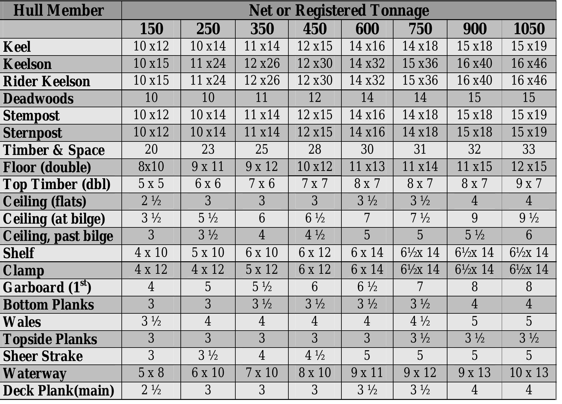
Table 8. Standard late 19"/early 20" century wooden vessel minimum scantlings for various tonnages . Dimensions are sided (width) by molded (thickness), or, in the case of planks or wales, thickness. All measurements in inches. From Desmond 1919: Table 3E. American Shipping (American Lloyd’s). These insurance companies would assign a

Table 9. Standard late 19"/early 20" century minimum fastener diameters for principle timbers, according to tonnage. All measurements in inches. (Desmond 1919: Table 3F). tonnage of the ship. These measurements are probably typical for the late 19" and early

The tonnage figures derived from individual hull member scantlings, and presented in members as measured in situ, and the tonnage estimates derived from each. tonnage can be derived. This figure, 272 tons, is probably a fairly accurate estimate of

than 13 feet. These are also probably fair estimates for the San Marcos vessel. would have an extreme breadth of less than 25 feet, and a depth of hold of somewhat less

Figure 48. The basic components and nomenclature of the running or sheave (single) block. From Bradley 1981: Figure 1 (top) and Stone 1993: Figure 78 (bottom).

Figure 49. The larger pulley sheave, FS 55, was found concreted to a large, unidentified metal artifact (FS 65) and covered in a tar-like deposit. The iron plate (FS 65) measures 22.8 cm by 40.8 cm (approximately 9 by 16 inches).

Figure 50. Sheave, FS 55, after conservation (top and side views).

![Figure 52. Diagram showing the three types of organic rope. After Lever 1998 [1819] Figures 1-3 Ropes were often tarred for better preservation in the marine environment; likewise, manila, were used in England as early as the 1830s. They would not become popular on](https://figures.academia-assets.com/31104706/figure_051.jpg) ](
](Figure 52. Diagram showing the three types of organic rope. After Lever 1998 [1819] Figures 1-3 Ropes were often tarred for better preservation in the marine environment; likewise, manila, were used in England as early as the 1830s. They would not become popular on
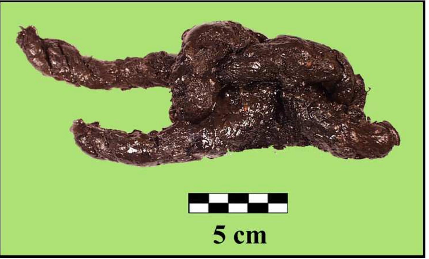


Figure 55. Staved container (cask) remains recovered from the San Marcos Shipwreck.


Figure 57. The base of a salt-glazed stoneware jug (FS 74), with an interior brown lead glaze, recovered from the shipwreck. This type of domestic utilitarian ware was used throughout the 19" century.

Figure 58. Small glass jar (FS 44) recovered from the shipwreck. This may have been an ink jar.

Figure 59. Leather shoe (FS 05) in situ, wedged under the outboard edge of the port garboard plank in unit 3 E, 4N


Figure 62. Mass of textile or fabric from 25 E, 3 N, about 60 cm away from the keel.

Table 13. Distribution of artifacts collected, by category Figure 63 is a map of the shipwreck site detailing the distribution of artifacts per fasteners is removed, the total sample is reduced to 184 artifacts.

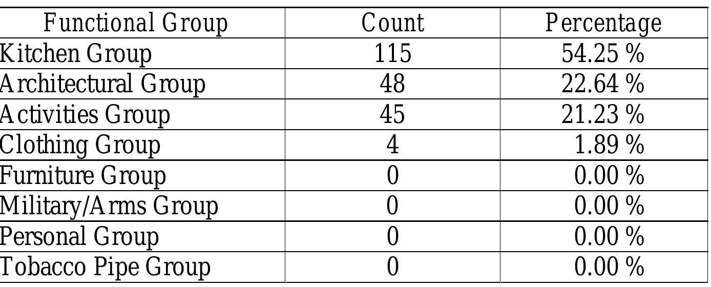
At this stage, and with such a small artifact sample, this quantitative analysis must be


Loading Preview
Sorry, preview is currently unavailable. You can download the paper by clicking the button above.
References (142)
- Albion, Robert G. 1939 The Rise of the Port of New York, 1815-1860. Charles Scribner's Sons, New York.
- Arnold, J. Barto III and Robert S. Weddle 1978 The Nautical Archaeology of Padre Island. Academic Press, New York. Baker, Henry A. and Roy Lett 1995 Featured Photograph. Florida Anthropologist 48(1).
- Baker, Henry A. 1996 Three Archaeological Features in the St. Marks River at San Marcos de Apalache State Historic Site. Florida Archaeological Reports No. 35. Florida Bureau of Archaeological Research, Tallahassee.
- Baker, Patrick and Graeme Henderson 1979 James Matthews Excavation: A Second Interim Report. International Journal of Nautical Archaeology 8(3): 225-244.
- Bauer, Jeff 1998 Shipwreck Site Survey in the Lower Florida Keys. World Wide Web, URL, http://www.cs.fsu.edu/\~jtbauer/bsc4933\. Florida State University Program in Underwater Archaeology, email: jtbauer@mailer.fsu.edu Bense, Judith A. 1978 Cultural Resource Reconnaissance in the St. Marks Wildlife Refuge, Florida. Report submitted to Interagency Archaeological Services, on file at Florida Bureau of Archaeological Research, Tallahassee.
- Blash, Douglas 2000 Geoarchaeology of the San Marcos Shipwreck. In An Archaeological Investigation of the San Marcos Shipwreck (8WA501) and a Submerged Cultural Resources Survey of the St. Marks River, 29 June to 07 August 1998, edited by Chuck Meide. Underwater Archaeology Research Report No. 2. Florida State University Program in Underwater Archaeology, Tallahassee, pp. 146-155.
- Bourne, Edward G. (ed). 1922 Narratives of the Career of Hernando de Soto in the Conquest of Florida. Allerton, New York.
- Boyd, Mark F. 1936 The Fortifications at San Marcos de Apalache (St. Marks, Wakulla Co., Florida). Florida Historical Quarterly 15 (1): 3-34.
- 1950 The Joint Operations of the Federal Army and Navy Near St. Marks, Florida, March 1865. Florida Historical Quarterly 29(2): 96-124.
- Boyd, Mark F., Hale G. Smith, and John W. Griffin 1951 Here They Once Stood: The Tragic End of the Apalachee Missions. University Press of Florida, Gainesville.
- Bradley, Charles 1981 The Ship's Fittings, Rigging Components and Rope Recovered from the Wreck of Le Machault. Microfiche Report Series No. 192, Parks Canada, Ottowa.
- Braudel, Fernand 1981 Civilization and Capitalism, 15th-18th Century. Translation by Siân Reynolds. Collins, London.
- Broadwater, John D. 1996 Final Report on the Yorktown Shipwreck Archaeological Project. 5 volumes. Submitted to the National Endowment for the Humanities, Williamsburg, Virginia.
- Browning, William 1989 Archaeological Resource Assessment Survey of the St. Marks Bridge at Newport, US-98/SR-30 in Wakulla County, Florida. Report prepared by the Florida Department of Transportation. On file at the Bureau of Archaeological Research, Tallahassee, Florida.
- Burney, Joseph 1872 Letter from the Secretary of War, Accompanying Engineer Reports upon the Survey of the mouth of the St. Marks River and of the Chotawahatchee River, Florida. U.S. 42 nd Congress, 2 nd Session, Senate Executive Document, no. 63: 2-7. Bushnell, Amy Turner 1990 How to Fight a Pirate: Provincials, Royalists, and the Defense of Minor Ports During the Age of Buccaneers. Gulf Coast Historical Review 5(2): 18-35.
- Cash, W.T. 1944 Newport As a Business Center. Apalachee: 13-28.
- Chapman, Fredrik Henrik af 1971 [1768] Architectura Navalis Mercatoria. Praegor Publishers, New York.
- Coble, Wendy M. 1994 A Comparative Analysis of Twenty-Four Barrel Heads from the Millecoquins Shipwreck. Manuscript on file, Program in Maritime History and Nautical Archaeology, East Carolina University, Greenville, North Carolina.
- Coker, W.S. 1994 The Columbian Exchange in the Floridas: Scots, Spaniards, and Indians, 1783- 1821. Colonial Latin American Historical Review 3(3): 305-325.
- 1995 The Papers of Panton, Leslie and Company, and John Forbes and Company. Florida Historical Quarterly 73(3): 353-358.
- Coker, W.S., and T.D. Watson 1986 Indian Traders of the Southeastern Spanish Borderlands: Panton, Leslie & Company and John Forbes & Company, 1783-1847. University of West Florida Press, Pensacola.
- Cook, Gregory 1997 The Readers Point Vessel: Hull Analysis of an Eighteenth-Century Merchant Sloop Excavated in St. Ann's Bay, Jamaica. Unpublished Master's Thesis, Department of Anthropology, Texas A&M University, College Station.
- Corbin, Annalies 2000 The Material Culture of Steamboat Passengers: Archaeological Evidence from the Missouri River. Series in Underwater Archaeology, No. 4. Kluwer Academic/ Plenum Publishers, New York.
- Cozzi, J. Coz 1999 The Hamilton Wreck: A Late Nineteenth-Century Vessel. Paper presented at the fifty-sixth annual meeting of the Southeastern Archaeological Conference. November 10-13, Pensacola, Florida.
- Crisman, Kevin J. and Arthur B. Cohn 1998 When Horses Walked on Water: Horse-Powered Ferries in Nineteenth-Century America. Smithsonian Institution Press, Washington, D.C.
- Dailey, Robert C., L. Ross Morrell, and Wilburn A. Cockrell 1972 The St. Marks Military Cemetery (8WA108). Bureau of Historic Sites and Properties, Bulliten No. 2, pp. 1-24. Florida Bureau of Archaeological Research, Tallahassee.
- Davis, T. Frederick 1946 Destruction of Port Leon, 1843. Florida Historical Quarterly 24(4): 287-290.
- Davis, Stephen 1997 Material Culture Research of Canadian Historic Shipwrecks: the Machault Legacy. In Artefacts from Wrecks: Dated Assemblages from the Late Middle Ages to the Industrial Revolution, edited by Mark Redknap, pp. 37-48. Oxbow Monograph No. 84. Oxbow Books, Oxford.
- De Kerchove, R. 1948 International Maritime Dictionary. D. van Nostrand, New York.
- Desmond, Charles 1919 Wooden Ship-Building. Rudder Publishing Company, New York.
- Dodd, Dorothy 1956 The Tallahassee Railroad and the Town of St. Marks. Apalachee 4: 1-12.
- Dunbar, James S. 1988 Letter to Leroy Irwin, Florida Department of Transportation, dated 19 October, re: description of methodology and results of an underwater auger survey in the right- of-way of the proposed U.S. 98 bridge over the St. Marks River. On file, Florida Bureau of Archaeological Research, Tallahassee.
- Dunbar, James S. and Steve J. Dasovich 1991 Archaeological Testing of a Proposed Observation Platform at Fort San Marcos de Apalache State Historic Site. Florida Bureau of Archaeological Research, Tallahassee.
- Ewen, Charles R. 1990 Soldier of Fortune: Hernando de Soto in the Territory of the Apalachee, 1539- 1540. In Columbian Consequences: Archaeological and Historical Perspectives on the Spanish Borderlands, Vol. 2, edited by D. H. Thomas, pp. 83-91.
- 1991 Anhaica: Discovery of Hernando de Soto's 1539-1540 Winter Camp. . In First Encounters: Spanish Explorations in the Caribbean and the United States, 1492- 1570, edited by Jerald T. Milanich and Susan Milbrath, pp. 110-118.
- Fairbanks, Charles H. 1964 Underwater Historic Sites on St. Marks River. The Florida Anthropologist 17:44-49.
- Gannon, Michael V. 1965 Cross in the Sand. University of Florida Press, Gainesville. Gawronski, Jerzy 1992 Functional Classifications of Artifacts of VOC-Ships: The Archaeological and Historical Perspective. In Underwater Archaeology Proceedings from the Society for Historical Archaeology Conference, edited by Don Keith and Toni L. Carrell. Society for Historical Archaeology, Kingston, Jamaica.
- Gawronski, Jerzy, Bas Kist, and Odilia Stokvis-van Boetzelaer 1992 Hollandia Compendium: A Contribution to the History, Archaeology, Classification and Lexicography of a 150 ft. Dutch East Indiaman (1740-1750). Elsevier Science Publishers, Amsterdam.
- Gerami, Abbas 1984 Hydrogeology of the St. Marks River Basin, Northwest Florida. Unpublished Master's Thesis, Department of Geology, Florida State University, Tallahassee.
- Godden, Geoffrey A. 1966 Encyclopedia of British Pottery and Porcelain. Bonanza Books, New York.
- Gould, Richard A. 1995 The Bird Key Wreck, Dry Tortugas National Park, Florida. Bulletin of the Australian Institute for Maritime Archaeology 19: 7-16.
- 2000 Archaeology and the Social History of Ships. Cambridge University Press, Cambridge.
- 1993 Sail's Last Century: The Merchant Sailing Ship 1830-1930. Conway's History of the Ship Series. Conway Maritime Press, London.
- Groene, Bertram H. 1981 Ante-Bellum Tallahassee. Florida Heritage Foundation, Tallahassee. Gulf Engineers & Consultants and Tidewater Atlantic Research 1992 Archaeological Documentation and Testing of a Mid-Nineteenth Century Tugboat at Hutchinson Island, Savannah, Chatham County, Georgia. Gulf Engineers & Consultants, Inc., Baton Rouge, Louisiana, and Tidewater Atlantic Research, Inc., Washington, North Carolina.
- Hann, John H. 1988 Apalachee: The Land between the Rivers. Ripley P. Bullen Monographs in Anthropology and History, No. 7. University Press of Florida, Gainesville.
- Hann, John H. and Bonnie G. McEwan 1998 The Apalachee Indians and Mission San Luis. University Press of Florida, Gainesville.
- Hardy, Meredith D. 2000 Ceramics. In An Archaeological Investigation of the San Marcos Shipwreck (8WA501) and a Submerged Cultural Resources Survey of the St. Marks River, 29 June to 07 August 1998, edited by Chuck Meide. Underwater Archaeology Research Report No. 2. Florida State University Program in Underwater Archaeology, Tallahassee, pp. 230-237.
- Harris, Marvin 1968 The Rise of Anthropological Theory. Crowell, New York.
- Hellman, Robert 1993 Spanish Dock: Fort San Marcos de Apalache. Manuscript on file at the Florida State University Program in Underwater Archaeology, Tallahassee.
- Henry, S. L. and Patrick H. Garrow 1982 Ceramic Type Descriptions (Appendix H). In City of Phoenix: Archaeology of the Original Townsite, Blocks 1 and 2, edited by J.S. Cable, S.L. Henry, and D.E. Doyal. Soil Systems Publications in Archaeology No. 1, pp. 465-472.
- Hocker, Frederick Martin 1991 The Development of a Bottom-Based Shipbuilding Tradition in Northwestern Europe and the New World. Ph.D. dissertation, Department of Anthropology, Texas A&M University, College Station. University Microfilms International, Ann Arbor, Michigan.
- Hoffman, Charles 1994 Narváez and Cabeza de Vaca in Florida. In The Forgotten Centuries: Indians and Europeans in the American South, 1521-1704, edited by Charles Hudson and Carmen Chaves Tesser, pp. 50-73. University of Georgia Press, Athens.
- Hoving, A. J. 1988 A 17 th -Century Dutch 134-foot Pinas, Part 1: A Reconstruction After Aaloude en Hedendaagse Scheepsbouw en Bestier by Nicolaes Witsen 1671. International Journal of Nautical Archaeology 17(3): 211-222.
- Hunter, Robert R. and George L. Miller 1994 English Shell-Edge Earthenware. The Magazine Antiques 145: 432-443.
- Johnson, Richard and Russell Skowronek 1983 A Quantitative Analysis of Patterning Potential in Shipwreck Artifact Assemblages. Paper presented at the 14 th annual meeting of the Conference on Underwater Archaeology, Denver.
- Jones, Calvin 1988 Preliminary Survey of Proposed St. Marks Bridge Replacement on Highway U.S. 98 at Newport, Florida, Wakulla County. Report on file at the Florida Bureau of Archaeological Research, Tallahassee.
- Jones, Ron 1974 A Report on the Survey of the Historic Site at San Marcos de Apalache on Sunday, November 10, 1974. Report prepared by the Florida State University Academic Diving Program. Submitted to the Florida Bureau of Archaeological Research, Tallahassee.
- Kilgo, John Patrick 1999 Searching for the Spray: Archaeological Investigations Along the St. Marks River. Unpublished Master's Thesis, Department of Anthropology, Florida State University, Tallahassee.
- Kilgore, John n.d. Old St. Marks in Florida: An Historical Work. Tallahassee, Florida. Kleij, Piet 1997 The Identification of a Ship's Place of Departure with the Help of Artifacts. In Artefacts from Wrecks: Dated Assemblages from the Late Middle Ages to the Industrial Revolution, edited by Mark Redknap. Oxbow Monograph No. 84. Oxbow Books, Oxford.
- Lever, Darcy 1998 The Young Sea Officer's Sheet Anchor, or a Key to the Leading of Rigging and to Practical Seamanship. Reprint of the 1819 edition. Dover Publications, Inc., Mineola, New York.
- MacGregor, David R. 1984 Merchant Sailing Ships 1815-1850: The Supremacy of Sail. Conway Maritime Press, London.
- Magnolia Monthly 1973 Story of the Rebel Gunboat Spray. September. Crawfordville, Florida. Majewski, Teresita and Michael O'Brien 1987 The Use and Misuse of Nineteenth-Century English and American Ceramics in Archaeological Analysis. In Advances in Archaeological Method and Theory, volume 11, edited by Michael B. Schiffer. Academic Press, San Diego.
- Mankowitz, W. 1953 Wedgwood. Dutton, New York.
- Marrinan, Rochelle A., John F. Scarry, and Rhonda Majors 1990 Prelude to de Soto: The Expedition of Panfilo de Narváez. In Columbian Consequences: Archaeological and Historical Perspectives on the Spanish Borderlands, Vol. 2, edited by D. H. Thomas, pp. 71-82. Smithsonian Institution Press, Washington and London.
- Maarleveld, Thijs 1998a Archaeology and Early Modern Merchant Ships: Building Sequence and Consequences, and Introductory Review. In Archaeological Heritage Management in Dutch Waters: Exploratory Studies, edited by Thijs Maarleveld, pp. 81-103. Scheepsarcheologie No. 5. Nederlands Instituut voor Scheeps-en onderwater Archeologie, Lelystad.
- 1998b Double-Dutch Solutions in Flush-Planked Shipbuilding: Continuity and Adaptations at the Start of Modern History. In Archaeological Heritage Management in Dutch Waters: Exploratory Studies, edited by Thijs Maarleveld, pp. 121-133. Scheepsarcheologie No. 5. Nederlands Instituut voor Scheeps-en onderwater Archeologie, Lelystad.
- Maarleveld, Thijs, B. Goudswaard, and R. Oosting 1998 New Data on Early Modern Dutch-flush Shipbuilding: Scheurrak T24 and Inschot/Zuidoostrak. In Archaeological Heritage Management in Dutch Waters: Exploratory Studies, edited by Thijs Maarleveld, pp. 105-120.
- Scheepsarcheologie No. 5. Nederlands Instituut voor Scheeps-en onderwater Archeologie, Lelystad.
- Marth, Del and Marty Marth (eds.) 1990 The Rivers of Florida. Pineapple Press, Sarasota, Florida. McCarthy, Mike 1983 Ships Fastenings: A Preliminary Study. The Bulletin of the Australian Institute for Maritime Archaeology. 7(1):1-24.
- Meide, Chuck 1998 Report on the Black Creek Shipwreck Survey, Clay County, Florida on April 24, 1998. Florida State University Program in Underwater Archaeology, Tallahassee. 1999 Investigation of the 19 th Century San Marcos Shipwreck (8WA501), St. Marks, Florida. Paper presented at the 56 th annual meeting of the Southeastern Archaeological Conference, November 10-13 th , Pensacola, Florida.
- 2000 An Archaeological Investigation of the San Marcos Shipwreck (8WA501) and a Submerged Cultural Resources Survey of the St. Marks River, 29 June to 07 August 1998. Underwater Archaeology Research Report No. 2. Florida State University Program in Underwater Archaeology, Tallahassee.
- Meide, Chuck, James A. McClean, and Edward Wiser 2001 Dog Island Shipwreck Survey 1999: Report of Historical and Archaeological Investigations. Underwater Archaeology Research Reports No. 4. Edited by Michael K. Faught, Jennifer F. McKinnon, William T. Hoffman, and Joseph M. Latvis. Florida State University Program in Underwater Archaeology, Tallahassee.
- Meide, Chuck, Della Scott, and James S. Dunbar 1999 City of Hawkinsville Archaeological Assessment: 08 March to 11 March 1999, Suwanee River, Old Town, Florida. Report Prepared by the Florida Bureau of Archaeological Research and the Florida State University Program in Underwater Archaeology, Tallahassee.
- Meide, Chuck and Terei Tarter 1992 An Archaeological Investigation of San Marcos Shipwreck 1, 8WA501. Report prepared by the Florida State University Academic Diving Program. Submitted to the Florida Bureau of Archaeological Research, Survey No. 3134, Tallahassee.
- Milanich, Jerald T. 1991 The Hernando de Soto Expedition. Garland Publishing, New York. 1995 Florida Indians and the Invasion from Europe. University Press of Florida, Gainesville.
- Milanich, Jerald T. and Charles Hudson 1993 Hernando de Soto and the Indians of Florida. University Press of Florida, Gainesville.
- Miller, George L. 1980 Classification and Economic Scaling of 19 th Century Ceramics. Historical Archaeology 14: 1-40.
- A Revised Set of CC Index Values for Classification and Economic Scaling of English Ceramics from 1787 to 1880. Historical Archaeology 25(1): 1-25.
- 1990 English Shell Edged Earthenware: Alias Leeds Ware, Alias Feather Edge. Proceedings from the Thirty-fifth Annual Wedgewood International Seminar. n.d. Date Ranges for the Periods of Highest Popularity and Production for the Different Types of Shell Edge Decorated Pearl and White Wares. Unpublished Manuscript.
- Mitchem, Jeffery M. 1991 Artifacts of Exploration: Archaeological Evidence from Florida. In First Encounters: Spanish Explorations in the Caribbean and the United States, 1492- 1570, edited by Jerald T. Milanich and Susan Milbrath, pp. 99-109.
- Muckelroy, Keith 1978 Maritime Archaeology. New Studies in Archaeology, Cambridge University Press, Cambridge.
- Nash, Mike 1991 Recent Work on the Sydney Cove Historic Shipwreck. Bulletin of the Australian Institute for Maritime Archaeology 15(1): 37-47.
- National Oceanic and Atmospheric Administration 1999 Historical Map and Chart Collection, State of Florida. World Wide Web, URL, http://anchor.ncd.noaa.gov/states/FL.htm, National Oceanic and Atmospheric Administration.
- Nöel Hume, Ivor 1969 Pearlware: Forgotton Milestone of English Ceramic History. Antiques 95: 390- 397. 1973 Creamware to Pearlware: A Williamsburg Perspective. In Ceramics in America, Ian M. G. Quimby, ed. University Press of Virginia,Charlottesville.
- Oertling, Thomas J. 1996 Ships' Bilge Pumps: A History of Their Development, 1500-1900. Studies in Nautical Archaeology, No. 2. Texas A&M University Press, College Station. Olds, Dorris L. 1962 History and Archaeology of Fort St. Marks in Apalachee. Unpublished Master's Thesis, Department of Anthropology, Florida State University, Tallahassee.
- Onís, Luis de 1969 Memoria sobre las negociaciones entre España y los Estados Unidos de América, 3 rd edition, with introduction by Jack D.L. Holmes. Ediciones J. Porrua Turanzas, Madrid. Owens, Harry P. 1966
- Apalachicola Before 1861. Ph.D. Dissertation, Department of History, Florida State University, Tallahassee.
- 1969 Port of Apalachicola. Florida Historical Quarterly 58: 1-25.
- Panamerican Consultants, Inc. 1996 Phase II Archaeological Data Recovery, Area 4, Fig Island Channel Site, Savannah Harbor, Georgia. Report prepared by Panamerican Consultants, Inc., Tuscaloosa, Alabama, for the U.S. Army Corps of Engineers, Savannah District.
- Pearson, Charles E. and Paul E. Hoffman 1995 The Last Voyage of El Nuevo Constante: The Wreck and Recovery of an Eighteenth-Century Spanish Ship off the Louisiana Coast. Louisiana State University Press, Baton Rouge.
- Peterson, Mendel L. 1974 Exploration of a 16 th Century Bahamian Shipwreck. Reprinted from National Geographic Society Research Reports, 1967 Projects. National Geographic Society, Washington, D.C. Praetzellis, Mary 1980 Ceramics in Historical Archaeology at the Golden Eagle Site, edited by Mary Praetzellis, Adrean Praetzellis, and Marley R. Brown III, pp. 7.1 through 7.84. Submitted to the Redevelopment Agency of the City of Sacramento by the Cultural Resources Facility, Anthropological Studies Center, Sonoma State University, California.
- Prokopetz, A. Wayne 1974 A Report on the Underwater Survey of Fort St. Marks (8WA108). Report prepared by the Florida State University Academic Diving Program. Submitted to the Florida Bureau of Archaeological Research, Tallahassee.
- Randolph, J.H., M.D. 1876 Modern St. Mark's. The Semi-Tropical 2: 409-411.
- Richardson, Thomas 1833 Mercantile Marine Architecture. London.
- Redknap, Mark 1997 Artefacts from Wrecks: Dated Assemblages from the Late Middle Ages to the Industrial Revolution. Oxbow Monograph No. 84. Oxbow Books, Oxford.
- Rees, Abraham 1820 [1970] Naval Architecture, a selection from The Cyclopedia; or Universal Dictionary of Arts, Sciences, and Literature. 1970 facsimile edition. U.S. Naval Institute, Annapolis, Maryland.
- Ringer, Jim 1979 Underwater Archaeological Excavation of the Auguste Site, Nova Scotia. Manuscript on file, Parks Canada, Ottowa.
- Rogers, William Warren 1986 Outposts on the Gulf: Saint George Island and Apalachicola from Early Exploration to World War II. University Press of Florida, Gainesville.
- Rucker, Brian R. 1992 Where the Buffalo Roamed: American Bison on the Gulf Coast in the Age of Exploration. Gulf Coast Historical Review 8 (1): 114-126
- Sahlins, Marshall D. and Elman R. Service 1988 Evolution and Culture. University of Michigan Press, Ann Arbor. Saltus, Allen R., Jr. 1999 Underwater Archaeology in Inland Waters. Paper presented at the 56 th annual meeting of the Southeastern Archaeological Conference, November 10-13 th , Pensacola, Florida.
- Schaniel, William C. 1988 New Technology and Culture Change in Traditional Societies. Journal of Economic Issues 22(2): 493-498.
- Schiffer, Michael B. 1987 Formation Processes of the Archaeological Record. University of New Mexico Press, Albuquerque.
- 1992 Technological Perspectives on Behavioral Change. University of Arizona Press, Tucson. Scott-Ireton, Della 1998 An Examination of Spanish Colonization Fleets in the Age of Discovery Based on the Archaeological and Historical Investigation of the Emanuel Point Ship. Unpublished Master's thesis, Department of History, University of West Florida, Pensacola.
- Sharp, Lauriston 1952 Steel Axes for Stone-Age Australians. In Human Problems in Technological Change, edited by Edward H. Spicer, pp. 69-81. Wiley, New York.
- Shofner, Jerrell H 1978 Daniel Ladd: Merchant Prince of Frontier Florida. The University Press of Florida, Gainesville.
- Skowronek, Russell K. 1984a Trade Patterns of Eighteenth Century Frontier New Spain: the 1733 Flota and St. Augustine. Master's Thesis, Department of Anthropology, Florida State University, Tallahassee. Volumes in Historical Archaeology, No. 1. The South Carolina Institute of Archaeology and Anthropology, Columbia.
- 1984b Archeological Testing and Evaluation of the Legare Anchorage Shipwreck Site, Biscayne National Park, Summer 1983. National Park Service, Southeast Archaeological Center, Tallahassee, Florida.
- Smith, Hale G. 1963
- Fort St. Marks Salvage Program, 1963. Florida State University Research Number HSM 149. Report prepared by the Department of Anthropology, Florida State University, for the National Park Service, Tallahassee.
- Smith, Roger C., James S. Dunbar, and Michael K. Faught 1997a An Underwater Archaeological Survey in the Santa Fe River, Florida, July 1997. Florida Archaeological Reports No. 36. Florida Bureau of Archaeological Research, Tallahassee.
- Smith, Roger C., James Miller, Sean M. Kelley, and Linda G. Harbin 1997b An Atlas of Maritime Florida. University Press of Florida, Gainesville.
- Smith, Roger C., James Spirek, John R. Bratten, and Della Scott-Ireton 1995 The Emanuel Point Ship Archaeological Investigations 1992-1995. Florida Bureau of Archaeological Research, Tallahassee.
- Smith, Roger C., John R. Bratten, J. Cozzi, and Keith Plaskett 1998 The Emanuel Point Ship Archaeological Investigations 1997-1998. Florida Bureau of Archaeological Research, Tallahassee.
- Smith, Sue N. 1990 A Guide to the Identification of Post-Contact Period Ceramics in St. Augustine, Florida. St. Augustine Archaeological Association, St. Augustine, Florida.
- South, Stanley 1977 Method and Theory in Historical Archaeology. Academic Press, New York.
- Souza, Donna J. 1998 The Persistence of Sail in the Age of Steam: Underwater Archaeological Evidence from the Dry Tortugas. The Plenum Series in Underwater Archaeology, No. 2. Plenum Press, New York.
- Spicer, Edward H. (ed.) 1952
- Human Problems in Technological Change. Wiley, New York. Stanbury, Myra 1994 HMS Sirius 1790: An Illustrated Catalogue of Artefacts Recovered from the Wreck Site at Norfolk Island. Special Publication No. 7. Australian Institute for Maritime Archaeology, Adelaide.
- Staniforth, Mark 1987 The Casks From the Wreck of the William Salthouse. Australian Journal of Historical Archaeology 5: 21-28.
- Stone, David Leigh 1993 The Wreck Diver's Guide to Sailing Ship Artifacts of the 19 th Century. Underwater Archaeological Society of British Colombia, Vancouver.
- Swindell, David E. and James S. Dunbar III 1985 Archaeological Survey and Testing of Three Proposed Dredge Areas in the St. Marks River, Wakulla County, Florida. Florida Bureau of Archaeological Research, Tallahassee.
- Thearle, S. J. P 1874 Naval Architecture: A Treatise on Laying and Building Wood, Iron, and Composite Ships. William Collins and Sons, London.
- Thomas, David Hurst. 1990 The Spanish Missions of La Florida: An Overview. In Columbian Consequences: Archaeological and Historical Perspectives on the Spanish Borderlands, Vol. 2, edited by D. H. Thomas, pp. 357-397. Smithsonian Institution Press, Washington and London.
- Thurston, William N. 1972 A Study of Maritime Activity in Florida in the Nineteenth Century. Ph.D. Dissertation, Department of History, Florida State University, Tallahassee.
- Vlierman, Karel 1997 The Ijsselmeerpolders: a "Source Book" for Late Medieval and Early Post- Medieval Wrecks Inventories. In Artefacts from Wrecks: Dated Assemblages from the Late Middle Ages to the Industrial Revolution, edited by Mark Redknap, pp. 15-36. Oxbow Monograph No. 84. Oxbow Books, Oxford.
- Ward, Jr., Rufus 1997 Shell-Edge Decorated Ceramics. Mississippi Archaeology 32 (1): 27-39.
- Wallerstein, Immanuel 1974 The Modern World-System, volume 1: Capitalist Agriculture and the Origins of the World-Economy in the Sixteenth Century. Academic Press, New York.
- Watkins, Charles Alan and Mark Matusiak 2001 Is This the Real Niagara? Naval History 15(1): 36-40.
- Weddle, Robert S. 1985 Spanish Sea: The Gulf of Mexico in North American Discovery 1500-1685. Texas A&M University Press, College Station.
- 1991 The French Thorn: Rival Explorers in the Spanish Sea, 1682-1762. Texas A&M University Press, College Station.
- Wenhold, Lucy L. 1956 The First Fort of San Marcos de Apalache. Florida Historical Quarterly 34: 301-314.
- Wetherbee, Jean 1996 White Ironstone: A Collector's Guide. Antique Trader Books, Dubuque, Iowa. White, Leslie A. 1949 The Science of Culture. Grove Pass, New York.
- White, Nancy Marie, Keith D. Ryder, Scott M. Grammar, and Karen L. Mayo 1995 Archaeological Survey of Dog Island, Franklin County, Florida. Report prepared by the Department of Anthropology, University of South Florida, submitted to the Florida Bureau of Archaeological Research, Tallahassee.
- Wilde-Ramsing, Mark U., Wilson Angley, Richard W. Lawrence, and Geoffrey J. Scofield 1992 The Rose Hill Wreck: Historical and Archaeological Investigations of an Eighteenth Century Vessel at a Colonial River Landing Near Wilmington, North Carolina. Underwater Archaeology Unit, Division of Archives and History, North Carolina Department of Cultural Resources, Kure Beach, North Carolina.
- Wilson, Eric J., Suzanne Finney, and Chuck Meide 2000 Tidal and Salinity Fluctuations on the San Marcos Shipwreck. In An Archaeological Investigation of the San Marcos Shipwreck (8WA501) and a Submerged Cultural Resources Survey of the St. Marks River, 29 June to 07 August 1998, edited by Chuck Meide. Underwater Archaeology Research Report No. 2. Florida State University Program in Underwater Archaeology, Tallahassee, pp. 141-145.
- Willey, Gordon R. 1949 Archeology of the Florida Gulf Coast. Smithsonian Miscellaneous Collections 113. Washington, D.C. Williams, Lindsey W. 1989 A Charlotte Harbor Perspective on de Soto's Landing Site. Florida Anthropologist 42: 280-294.
- Wills, Geoffrey.
- Wedgwood. Chartwell Books, Inc., Secaucus, New Jersey.
- Wright, James Leitch Jr.
- William Augustus Bowles: Director General of the Creek Nation. University of Georgia Press, Athens. BIOGRAPHICAL SKETCH
- Chuck Meide was born and raised a short barefoot walk from the ocean in Atlantic Beach, Florida. He entered the Florida State University in 1989, earning a degree in Anthropology and English, with honors, in 1993. He began graduate work in Anthropology at FSU the following year, focusing on underwater archaeology. While at FSU, Chuck became a NAUI Diving Instructor, and has served as a university instructor since 1993, teaching basic scuba, supervising research dives, and training science divers in a variety of advanced diving technologies. Throughout his career while at FSU, Chuck has worked as an archaeologist on a variety of shipwreck sites throughout Florida, the Southeast, and the Caribbean. These include one of Tristán de Luna's galleons lost at Pensacola in 1559 (Florida's oldest known shipwreck), a probable Spanish patache of the 1622 fleet in the Dry Tortugas, the French explorer La Salle's ship La Belle (1686) in
- Matagorda Bay, Texas, the Kingstown Harbour Shipwreck in St. Vincent and the Grenadines (believed to be a French warship lost in the late 18 th century), the Western river steamboat Ben Sherrod (1837) at Fort Adams, Mississippi, the Norwegian lumber bark Vale (1899) at Dog Island, Florida, the Suwannee River steamboat City of Hawkinsville (abandoned in the 1920s), and many other unidentified wrecks in the Dry Tortugas, the Keys, and both Atlantic and Gulf coasts of Florida. Chuck conceived of, organized, and directed the Dog Island Shipwreck Survey in 1999, a project which is