Archaic and Late Prehistoric Adaptation in Southwestern Wyoming: The Frontier Pipeline Excavations (original) (raw)
Abstract
Figures (122)
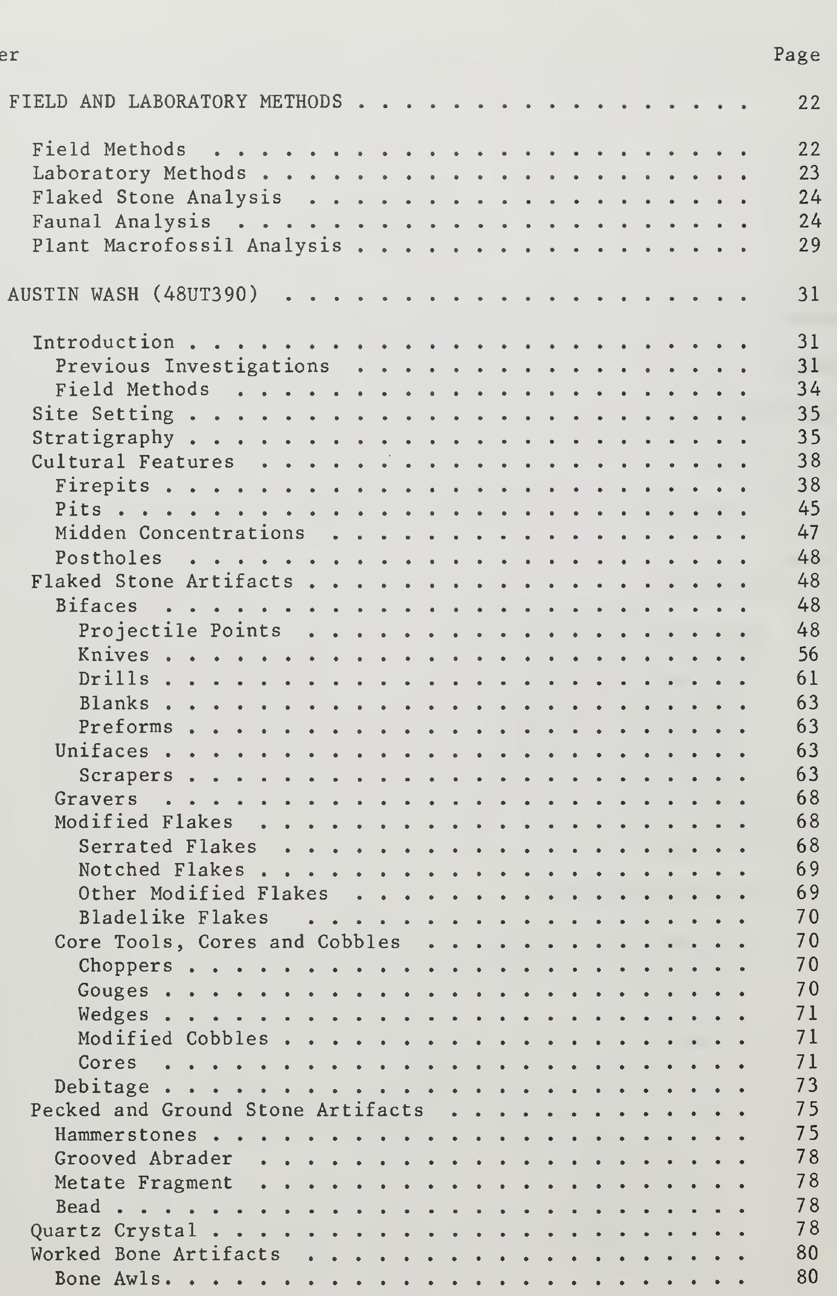
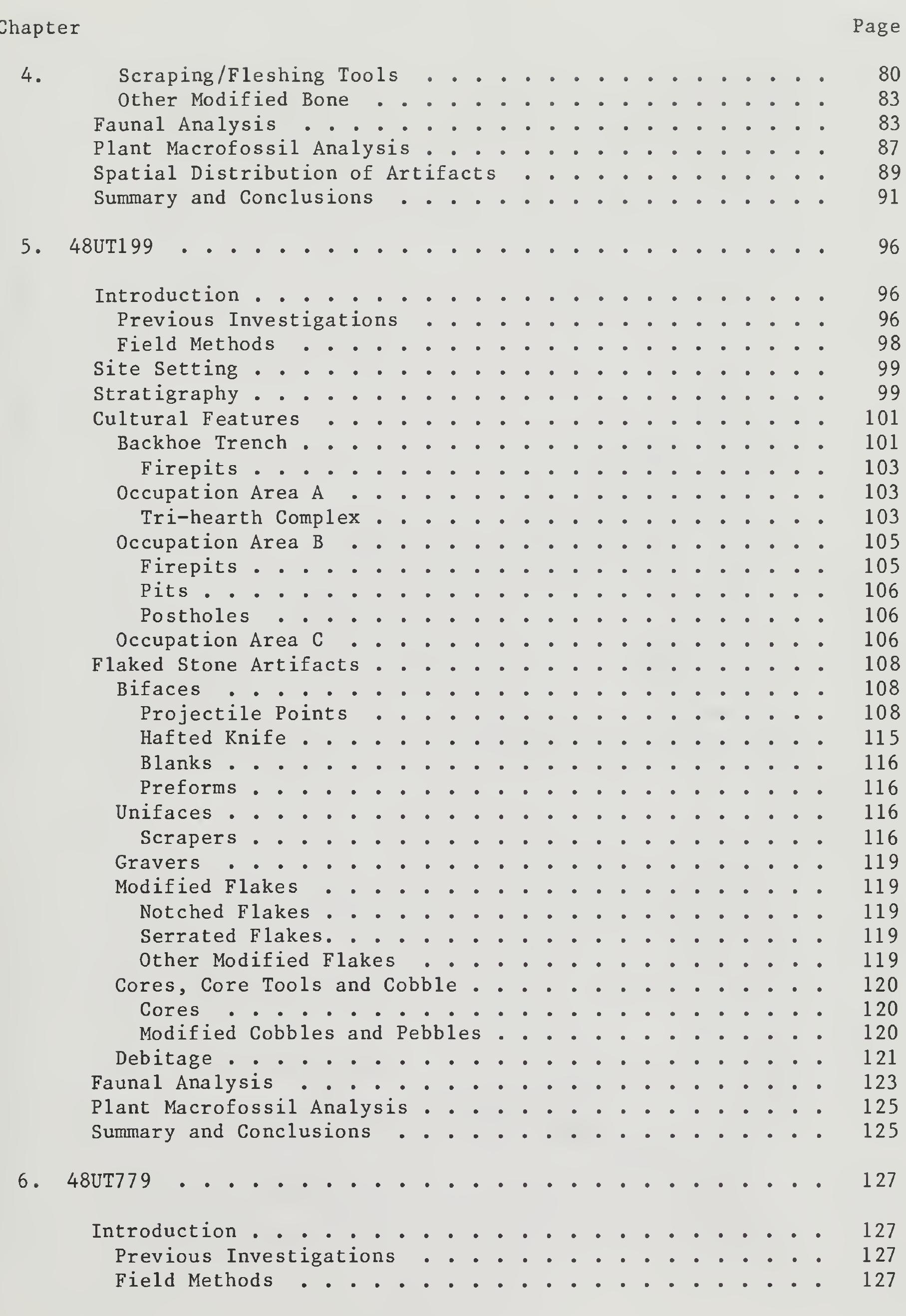
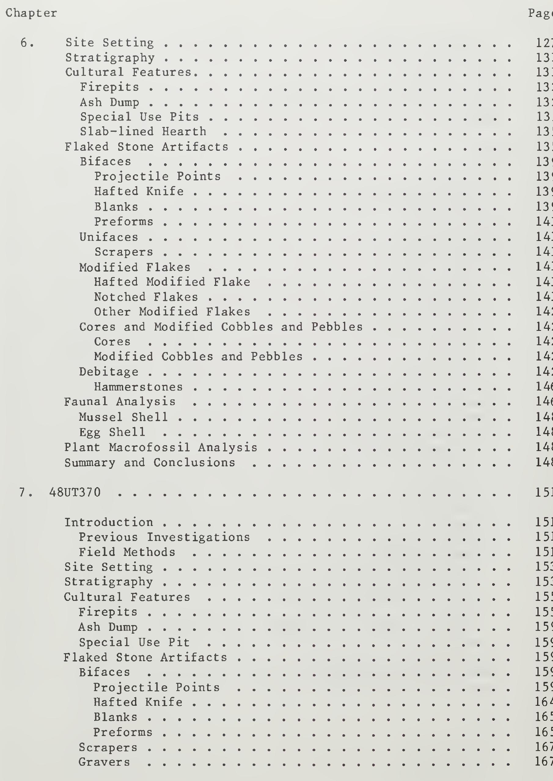
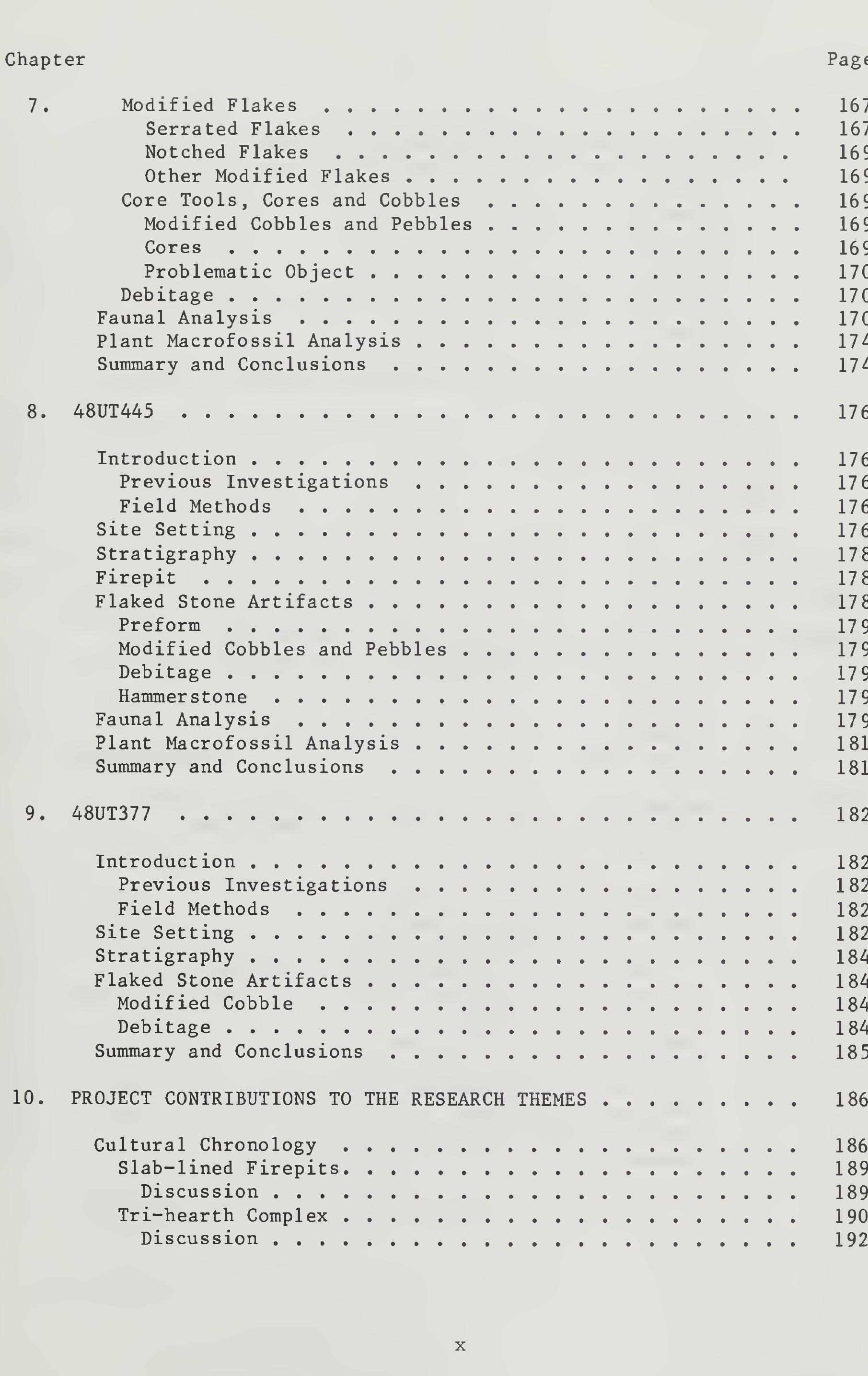
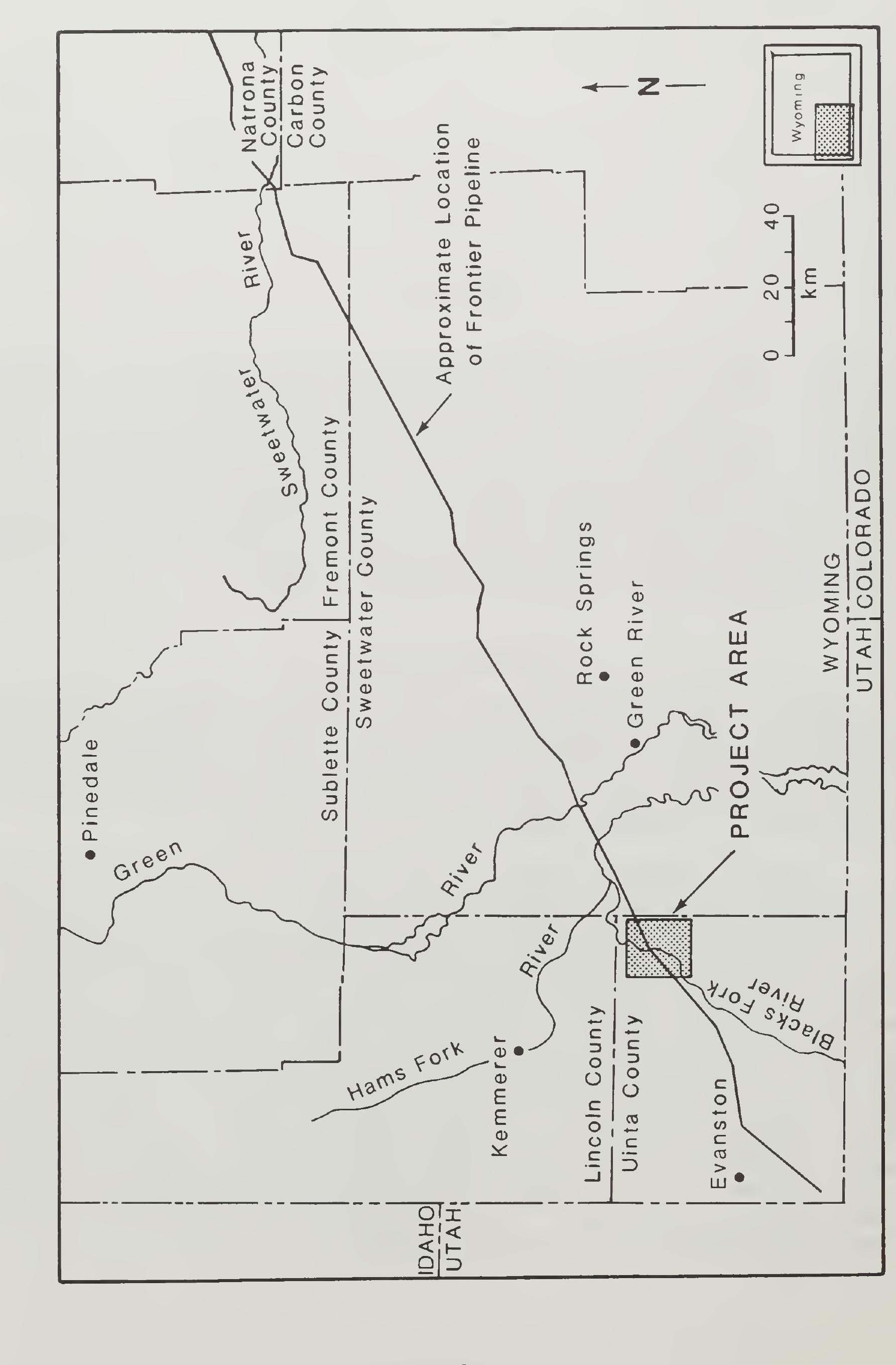
The study presented herein is an extensive data recovery program by P-III Associates at six prehistoric sites near Church Butte, in northeas Uinta County, Wyoming. This excavation program was part of the Bureau of Land Management (BLM) compliance requirements for approval of the 288-mile Frontier Crude Oil and Condensate Pipeline from Evanston to Casper, Wyoming. The excavations resulted in the recovery of over 20,000 artifacts and the discovery of more than 35 features. The excellently described results of this project (with ample graphics) provide a valuable research contribution and readable reference to the prehistory of the area from the Early Archaic to Late Prehistoric periods.
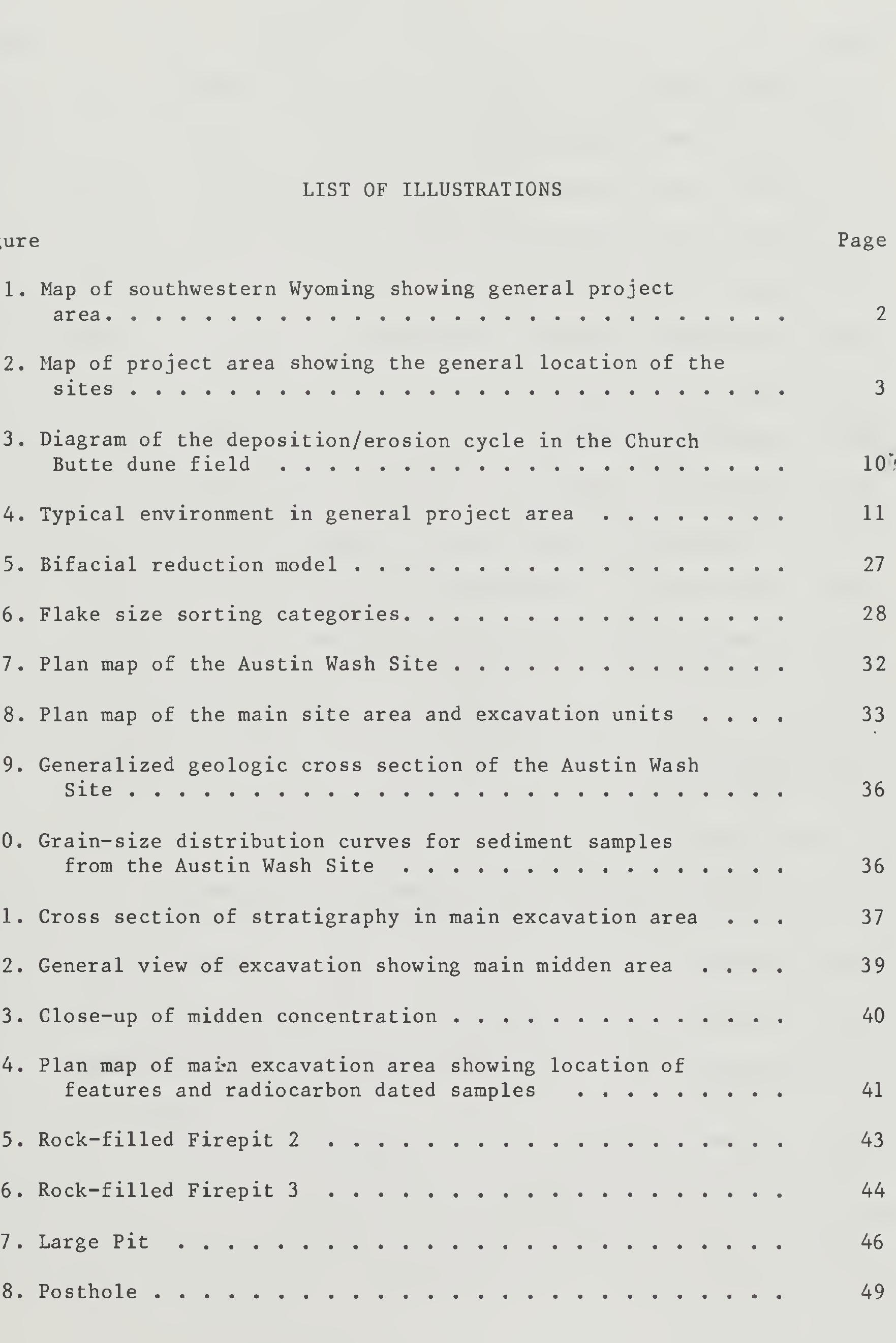
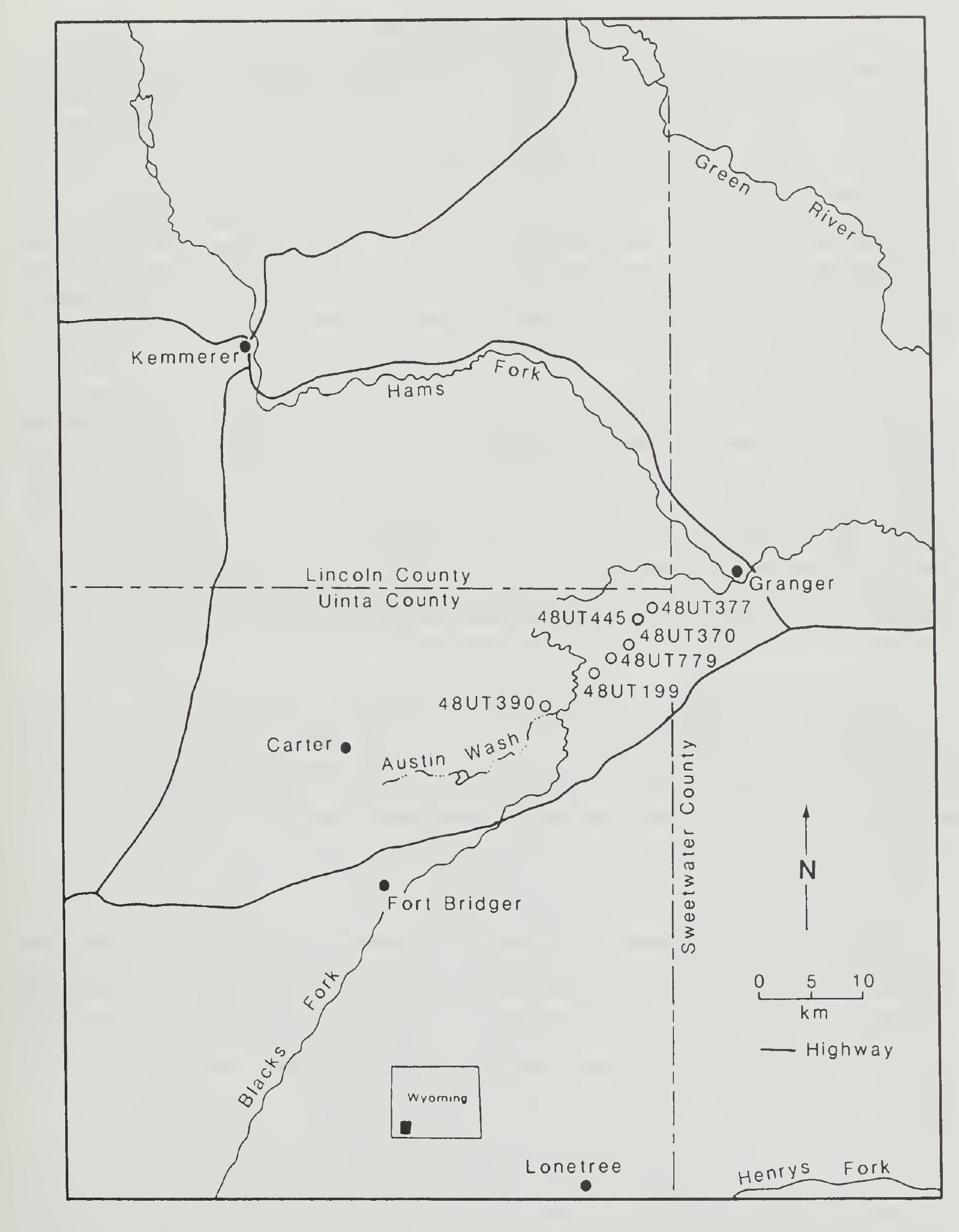
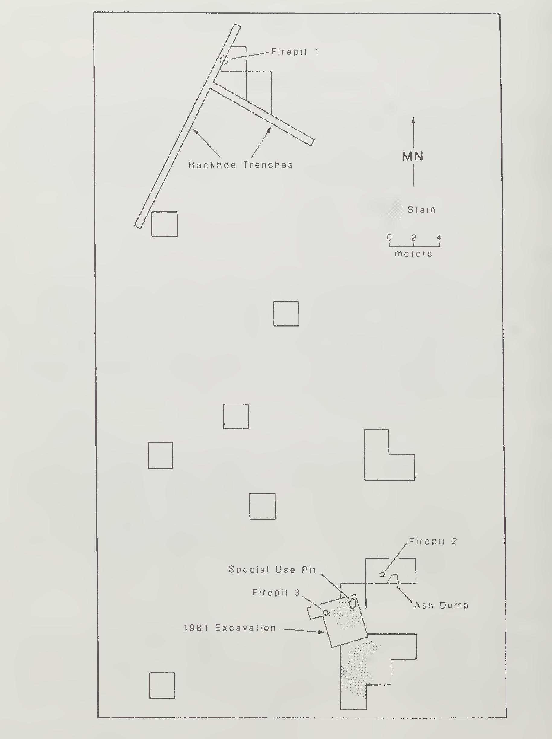
Figure 2. Map of project area showing the general location of the sites, Uinta County, Wyoming.
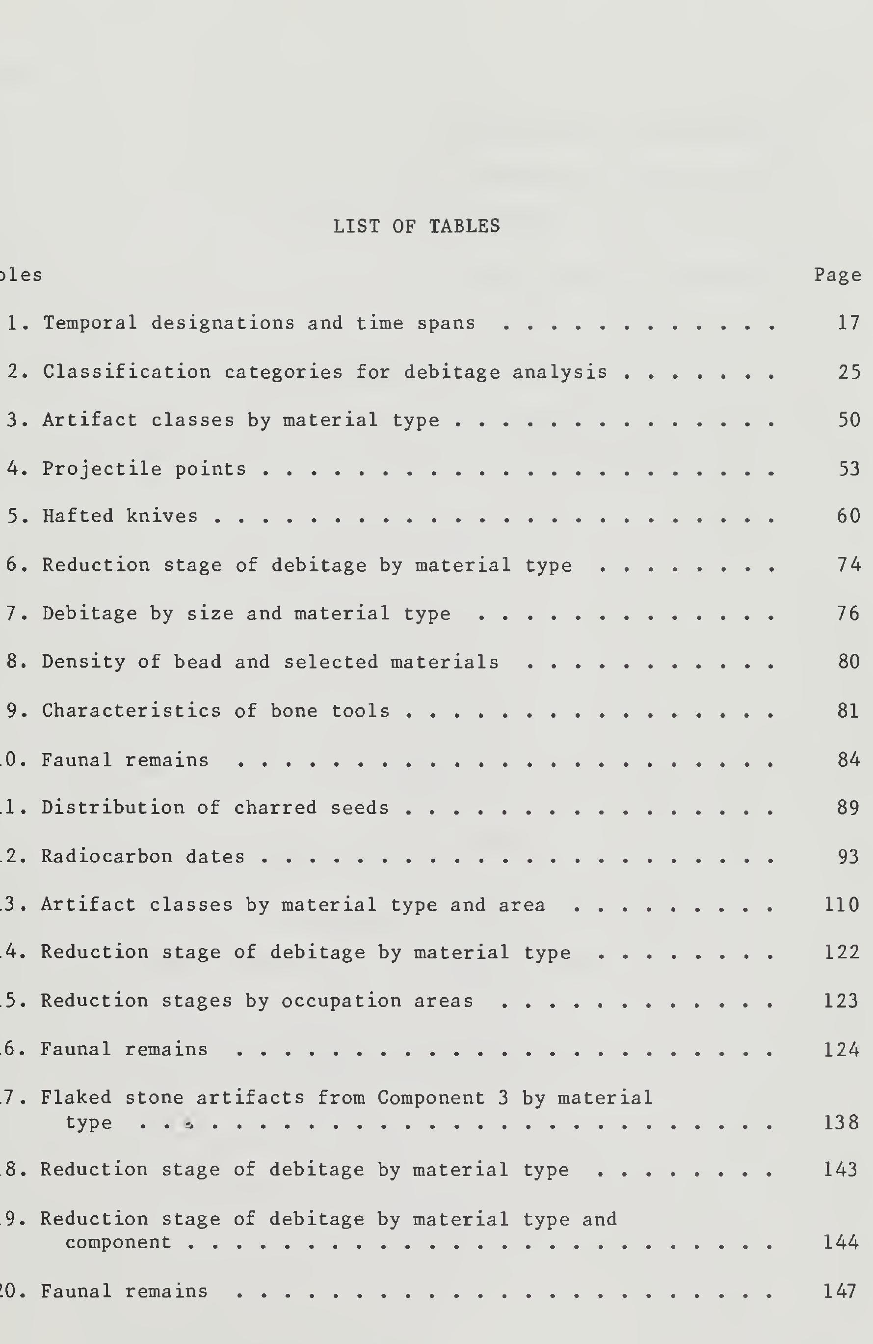
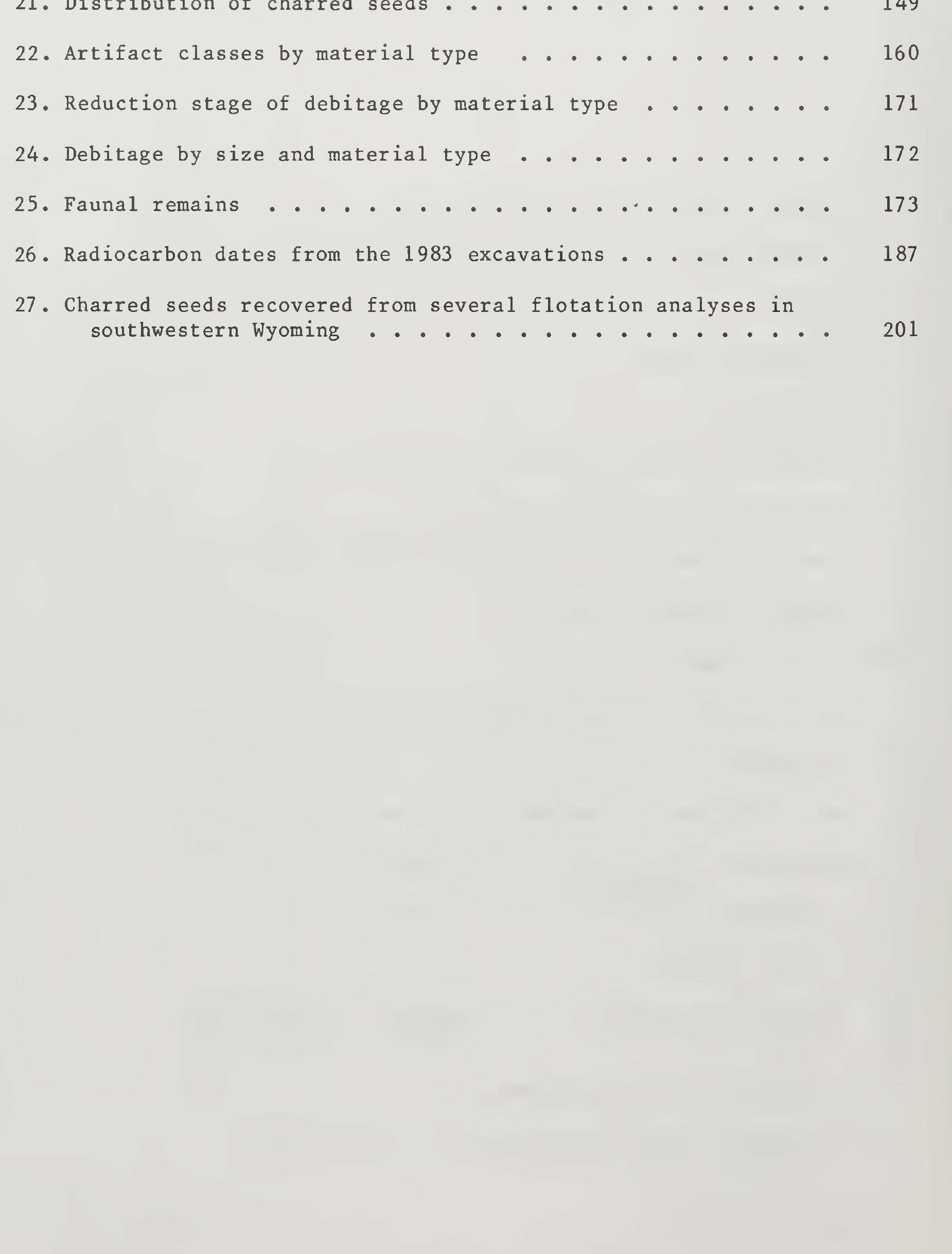
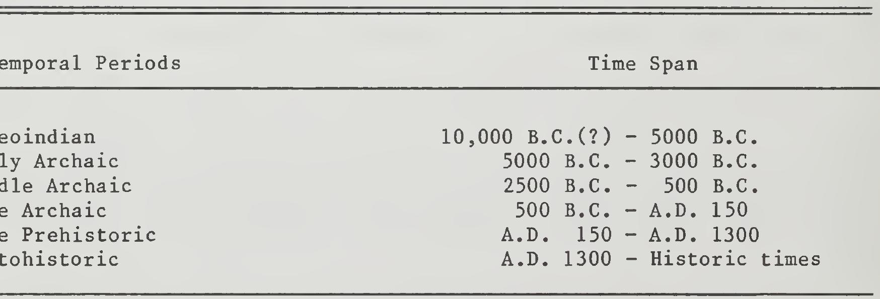
Table 1. Temporal designations and time spans. Excavated sites in the region that have produced evidence of Paleo- indian occupation include the Pine Springs site (Sharrock 1966) and the Finley site (Moss 1951). The Pine Springs site produced several diagnostic Paleoindian projectile points and early radiocarbon dates. Unfortunately, the deposits at the site were mixed and cultural temporal associations of the artifactual material are uncertain. The Finley site, excavated in the 1940s, is the most thoroughly excavated and reported Paleoindian site in southwestern Wyoming. The site, a kill site for a now-extinct species of bison, dates to about 7000 B.C. and contains both Eden and Scottsbluff points.
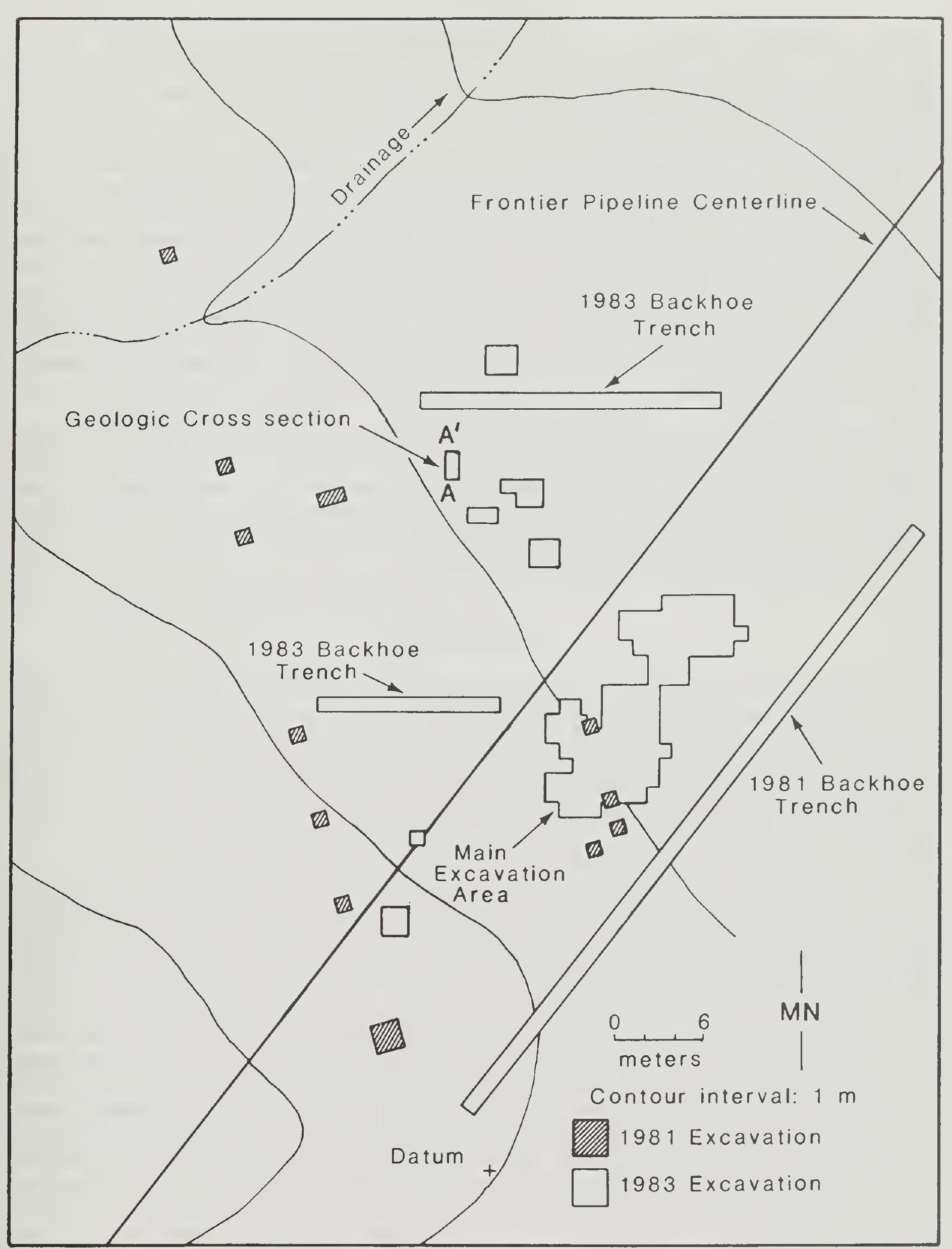
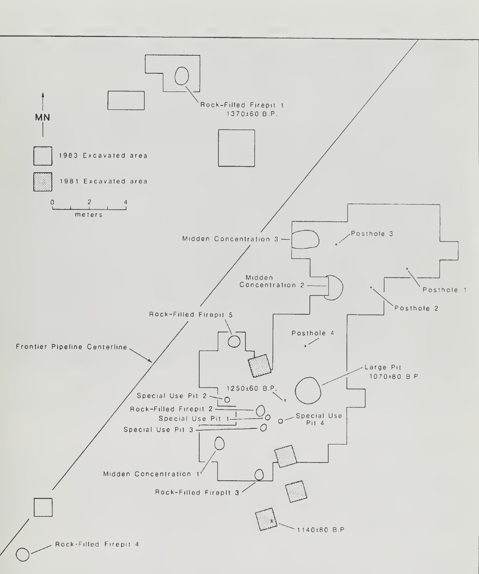
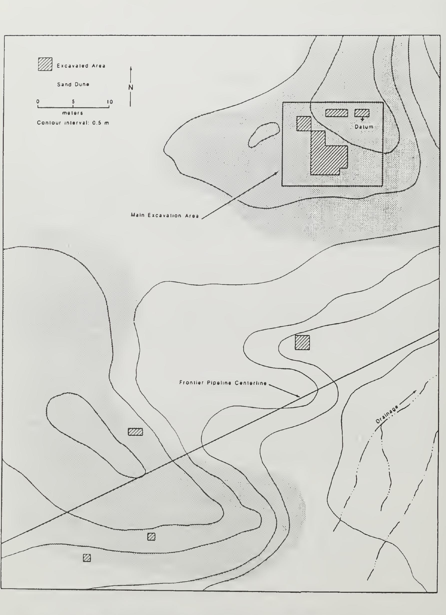
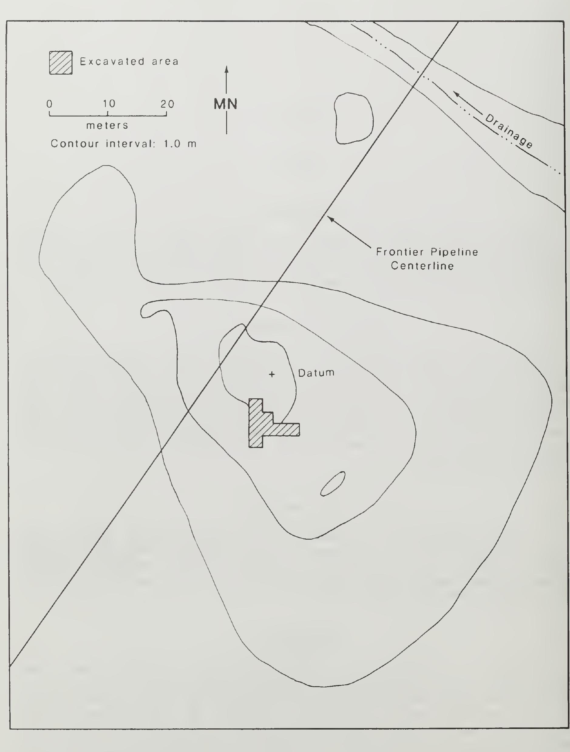
Fig. 8. Plan map of the main site area and excavation units, Austin Wast ite, 48UT390, Uinta County, Wyoming.
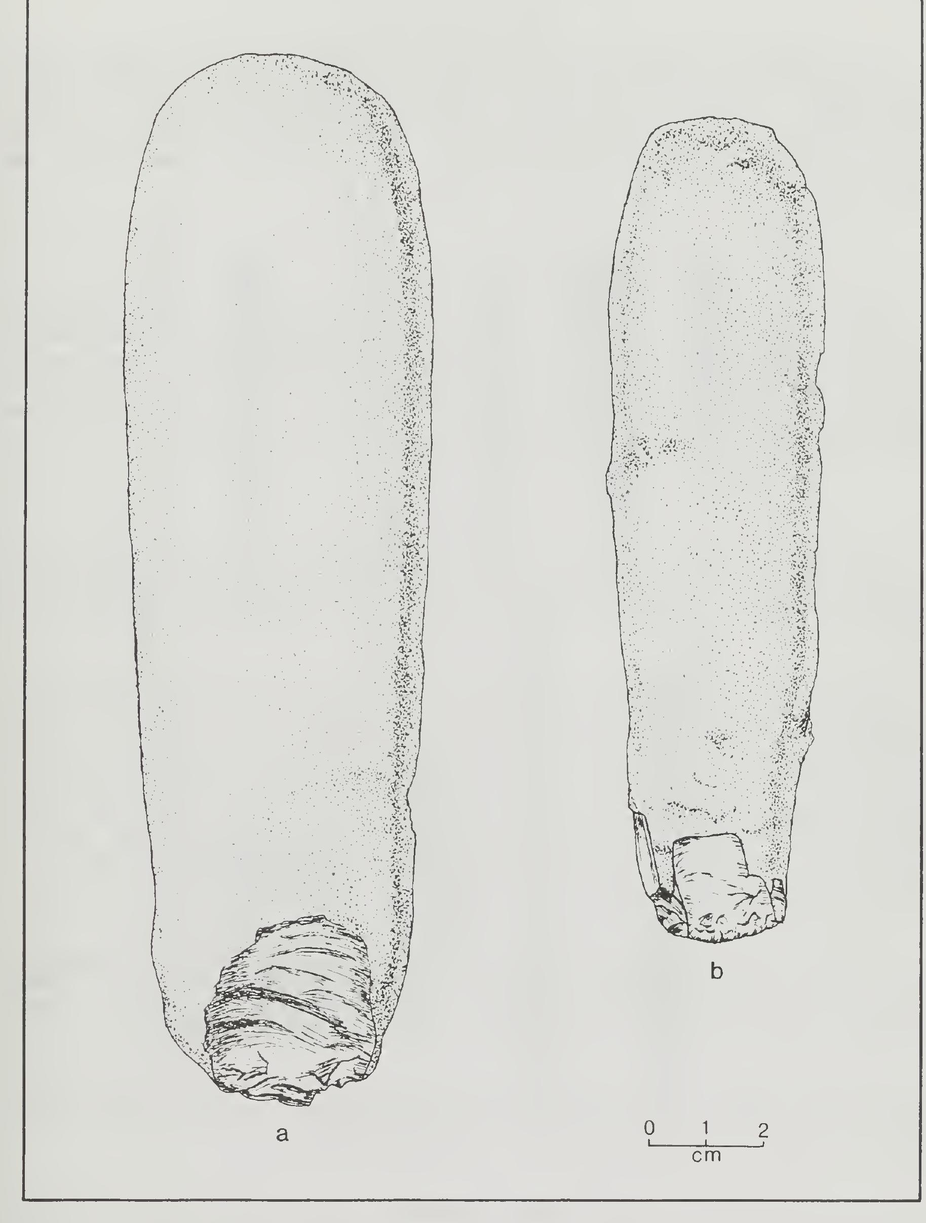
Fig. 29. Selected Class I hammerstones, Austin Wash Site, 48UT390, Uint: County, Wyoming.
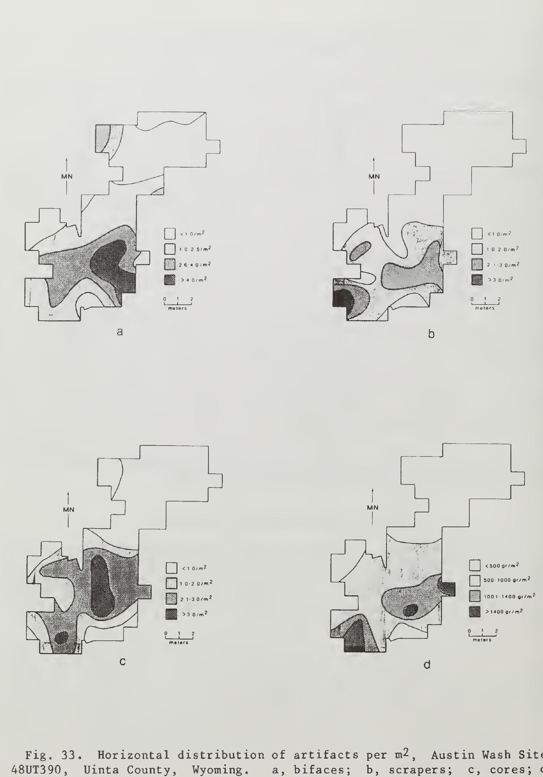
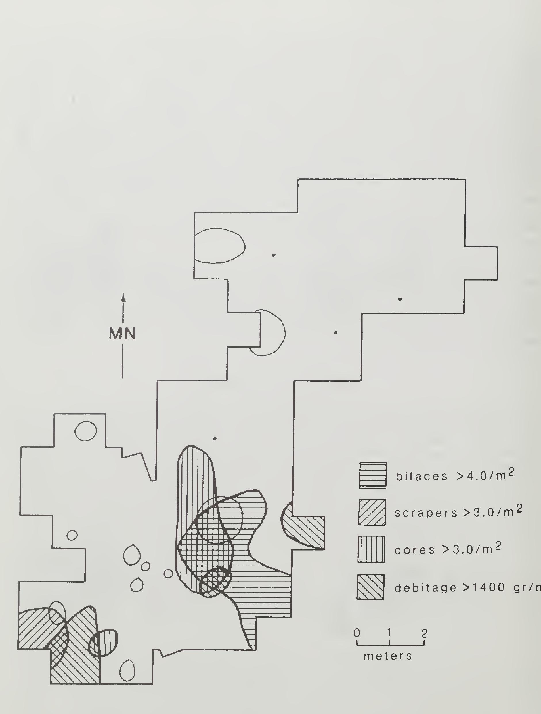
One of the goals of excavating a block area at this site is to deter- mine whether individual activity areas could be identified. Hodder and Orton (1976) discuss a number of techniques for analyzing spatial distri- bution of artifacts. One such technique, trend surface analysis (Hodder and Orton 1976:155), smooths the data and extracts differential spatial trends in the distribution of artifacts.
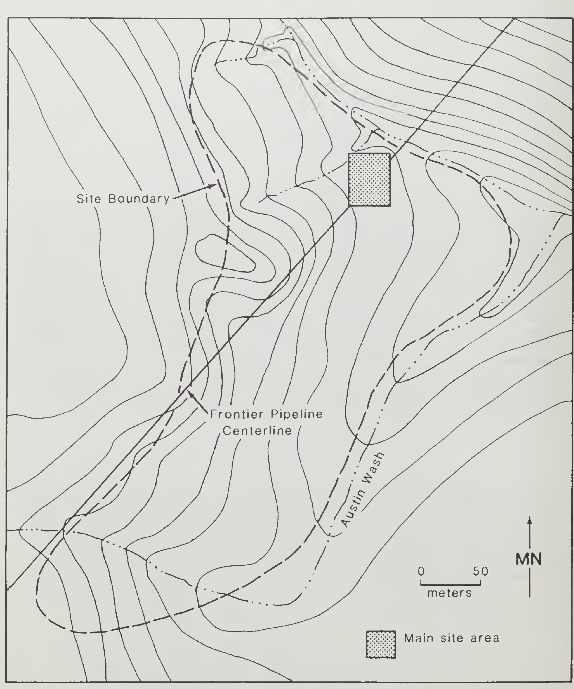
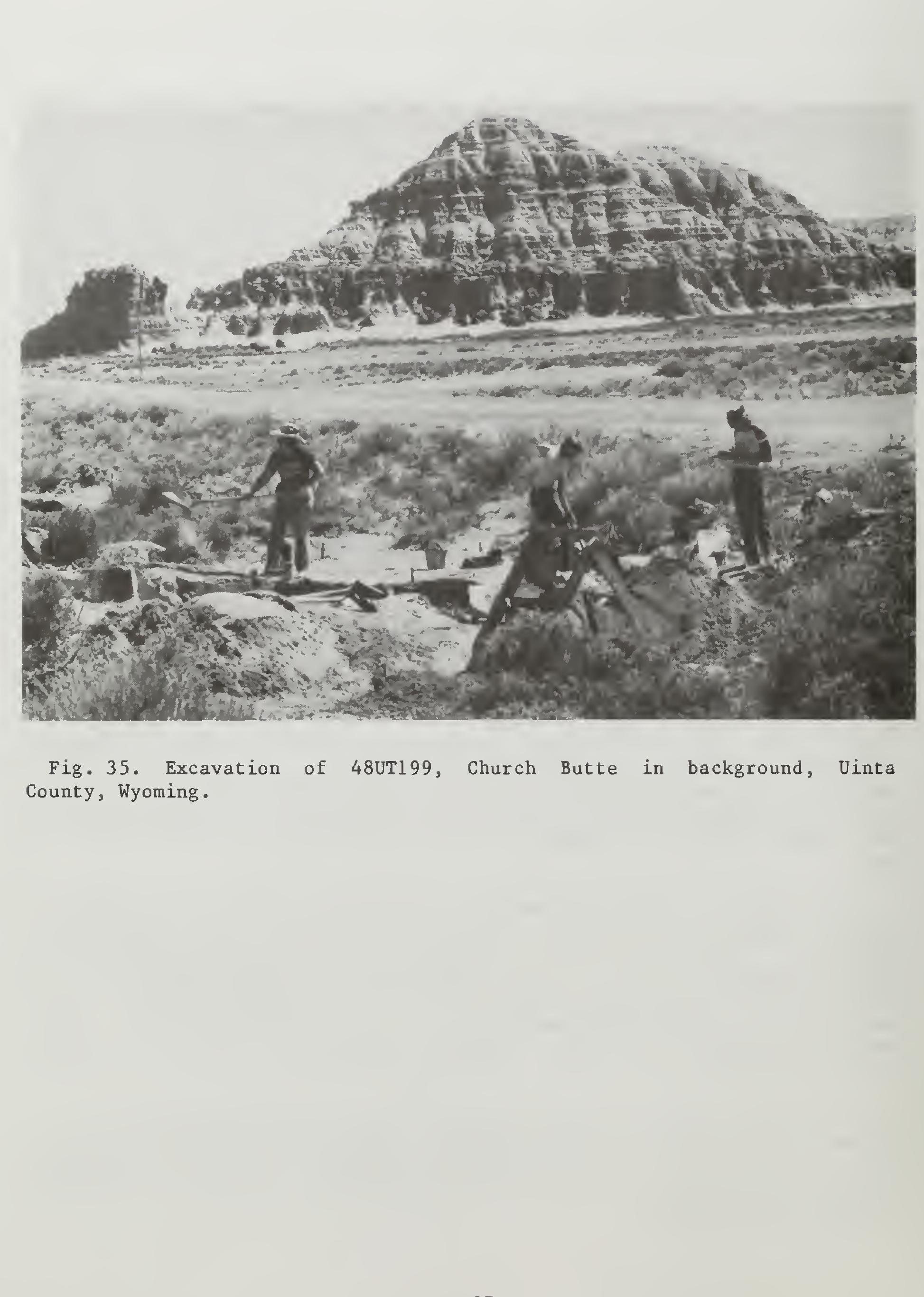
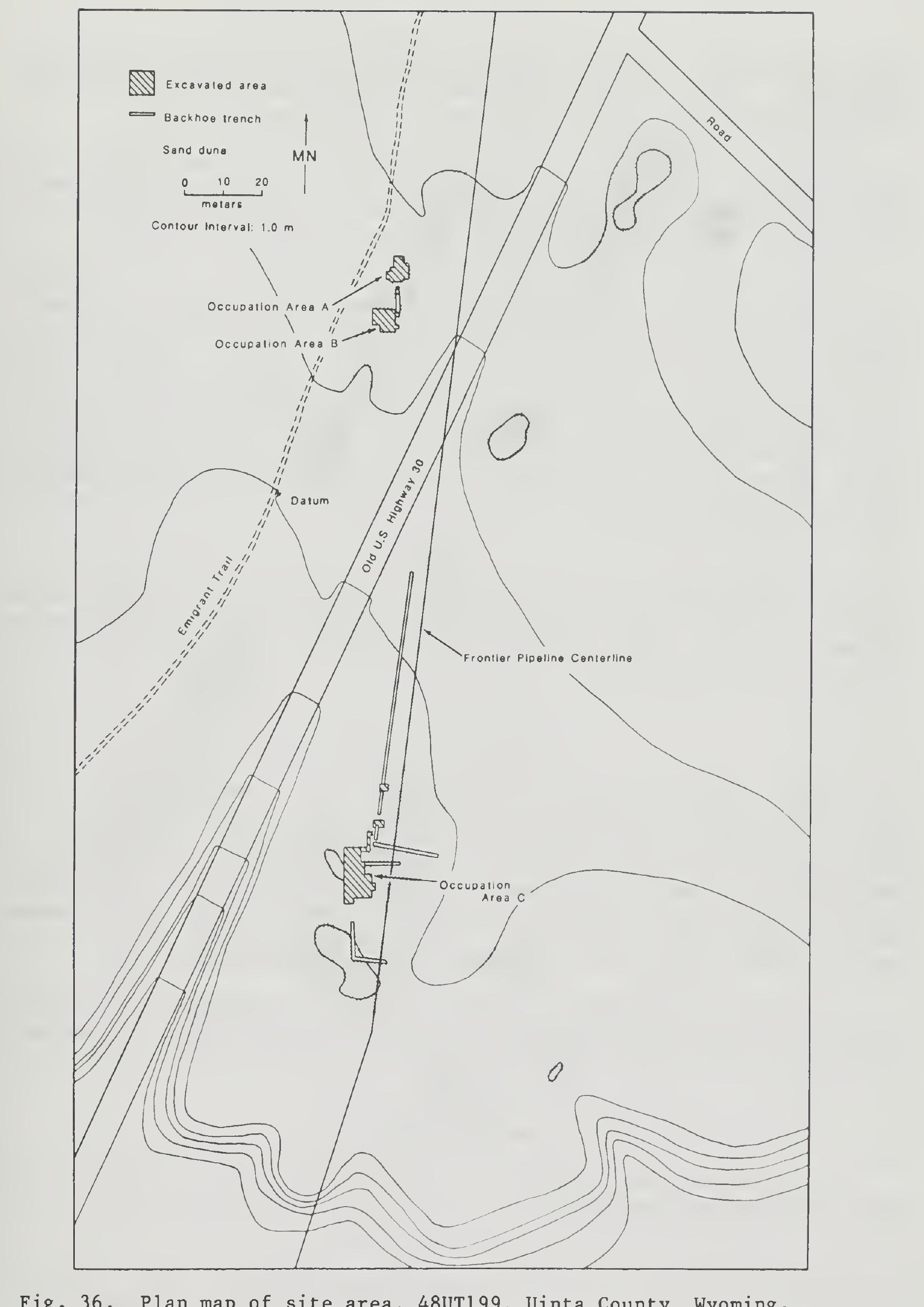
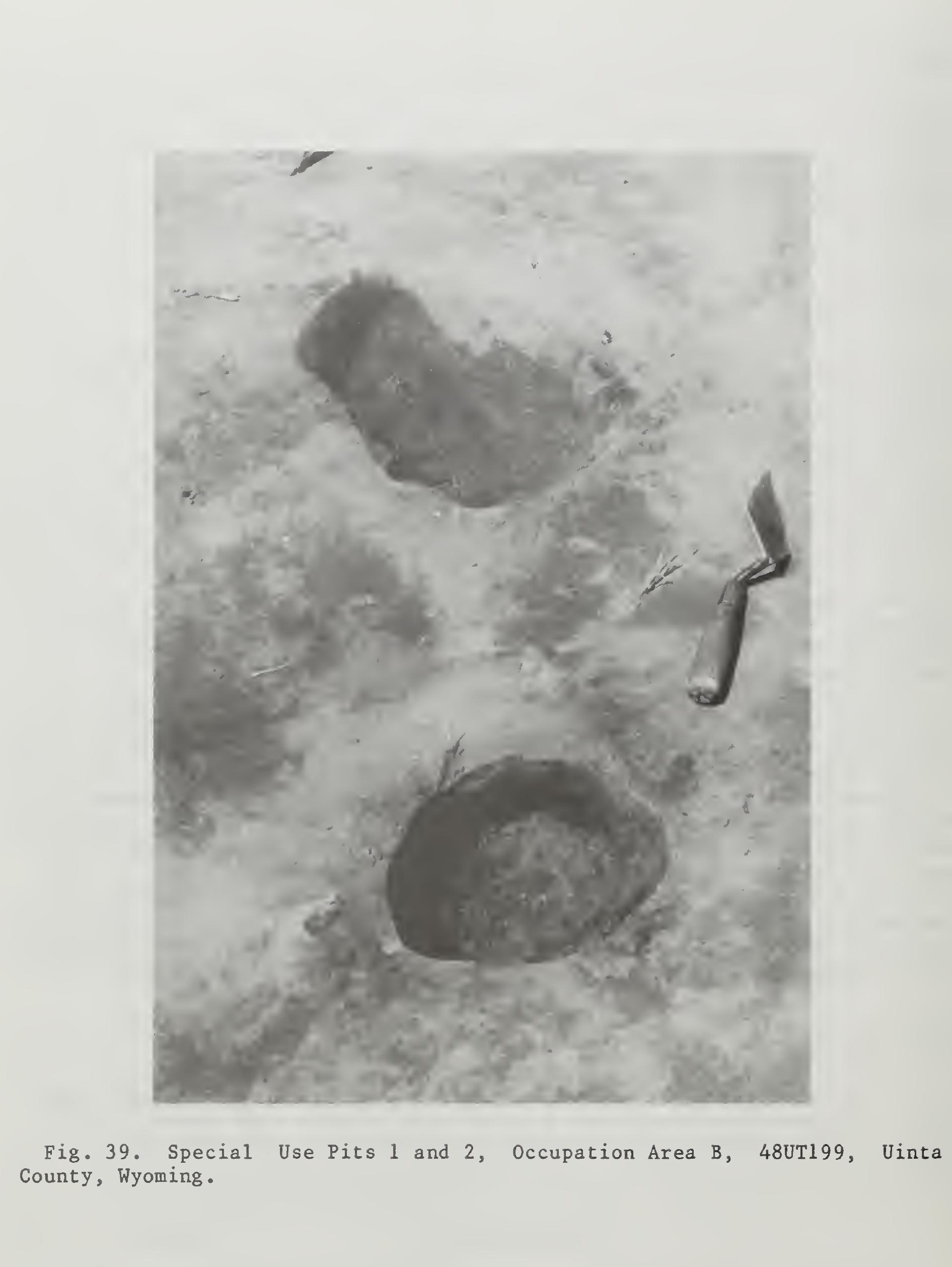
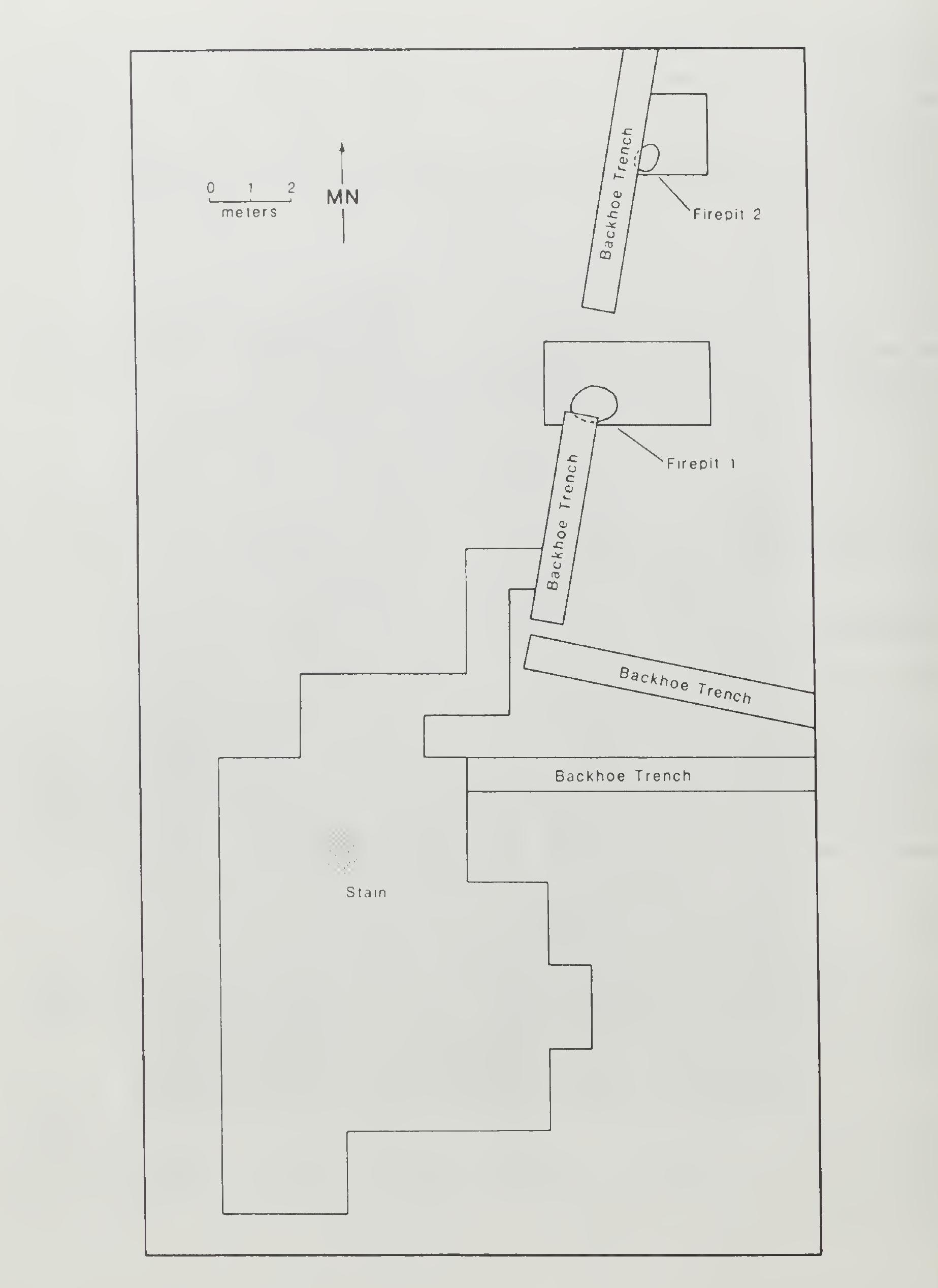
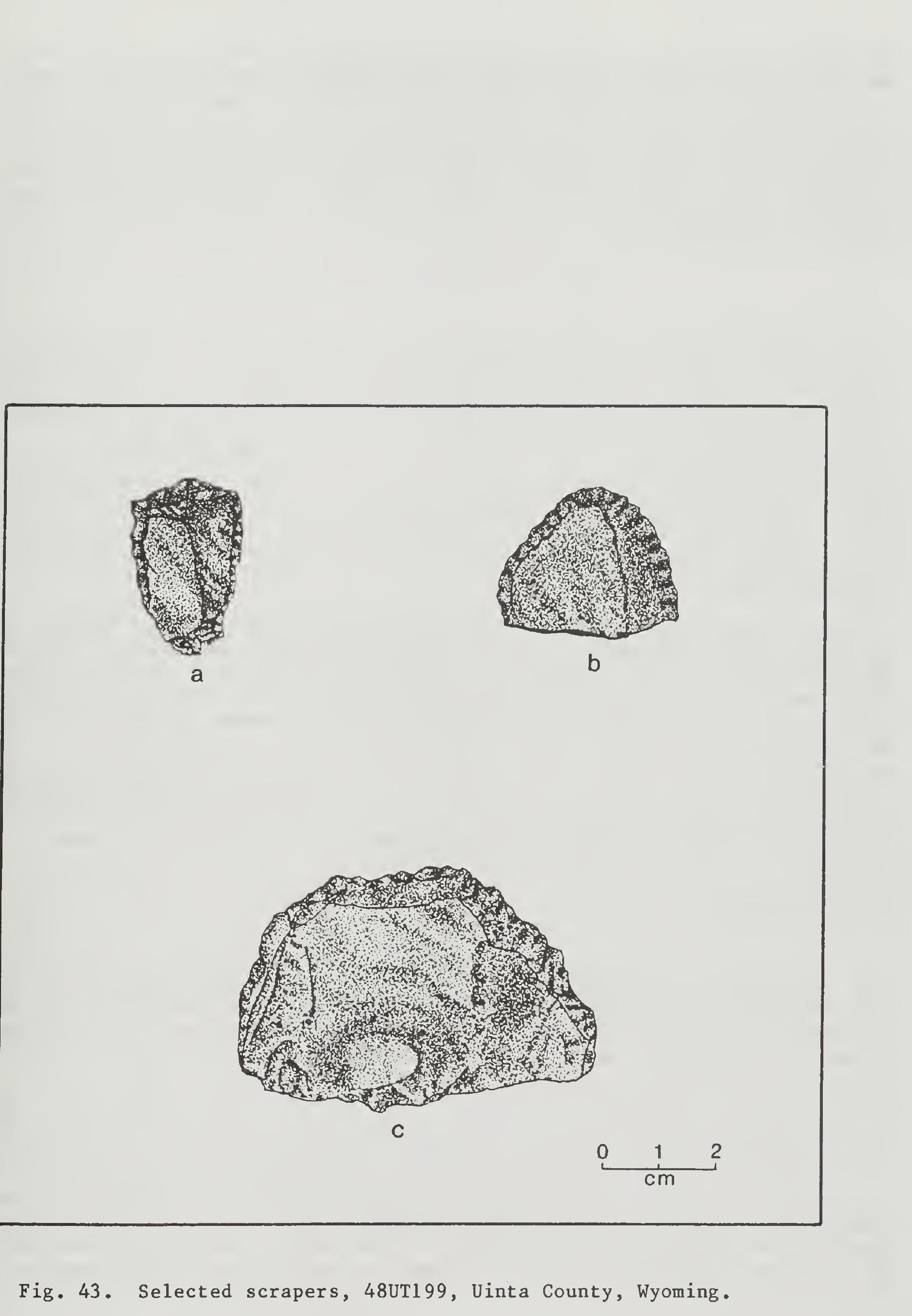
In 1979 one of the occupational loci of the site was located by Western Wyoming College during the survey of a portion of the Trailblazer Pipeline. Unaware that the site complex had already been designated as 48UT11, Western Wyoming College assigned the site number 48UT199 to the occupational locus which measured 100 by 130 m and consisted of a_ lithic Scatter with tools and an associated scatter of thermally altered rock. The site boundary of this locus extends north almost to old U.S. Highway 30 (Miller 1982).
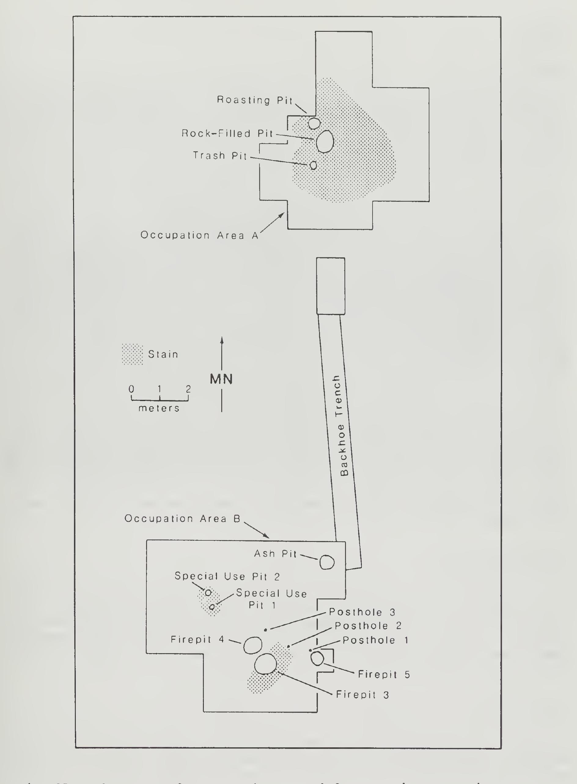
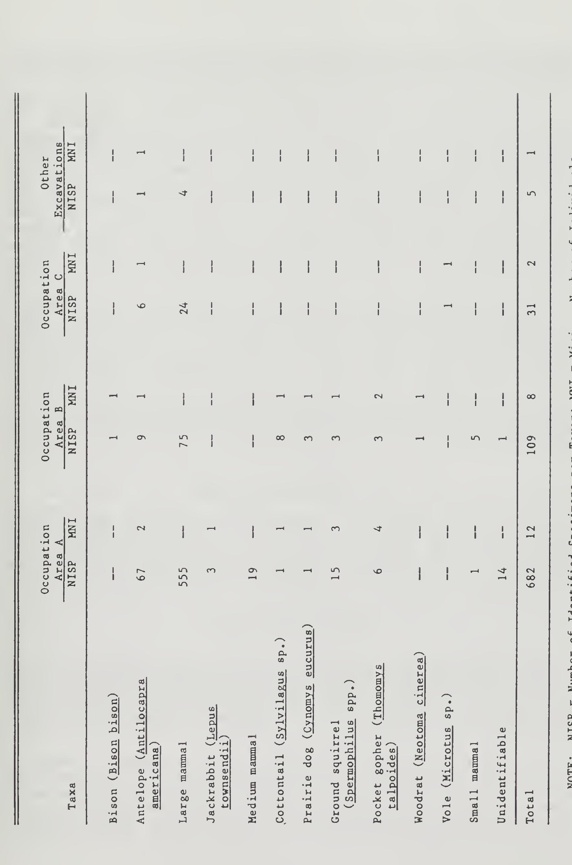
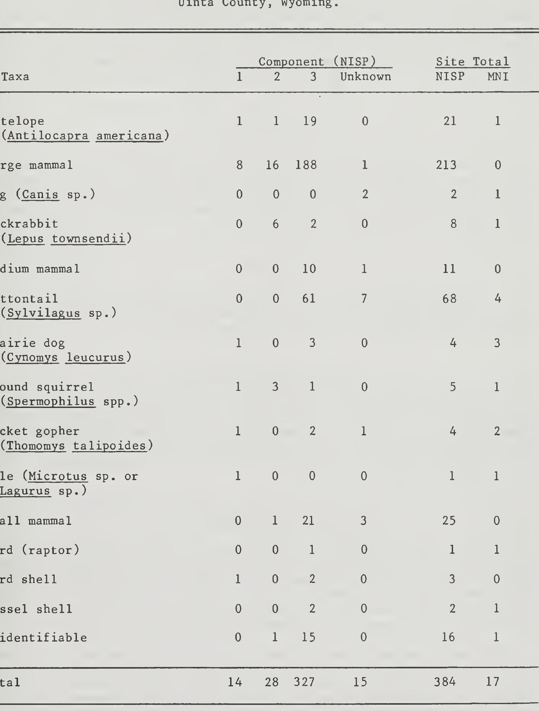
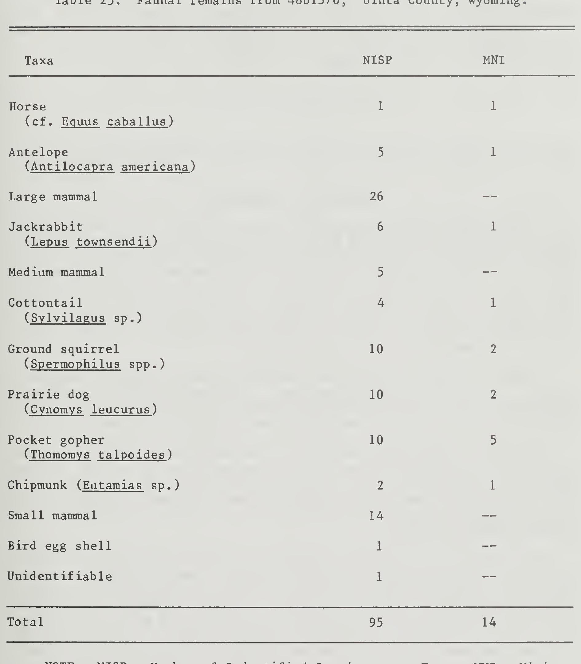
Occupation Area A produced about 82% of the total collection. The majority of the fragments in this area are from at least two antelope. The remaining specimens are distributed between five other identifiable genera, jackrabbit, cottontail, prairie dog, ground squirrel and pocket gopher. One hundred and twenty-five fragments were burned from this area. Of these burned specimens, 124 were antelope or large mammal fragments including three mandible, one tibia and one phalanx specimens, and 119 other frag- ments. The remaining burned element was a femur from a jackrabbit. The specimens were highly weathered from this occupation area with a modal weathering stage of 4.
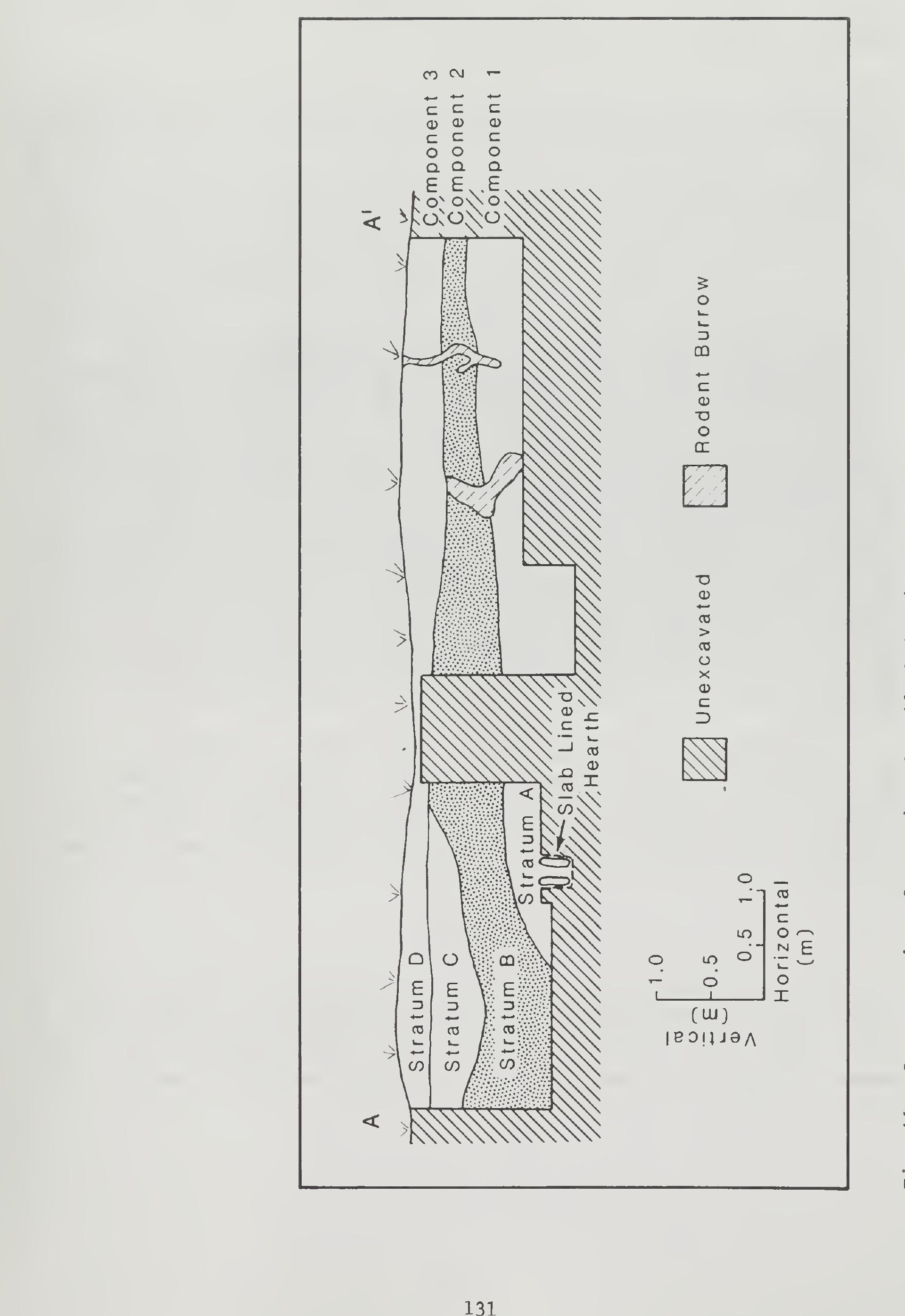
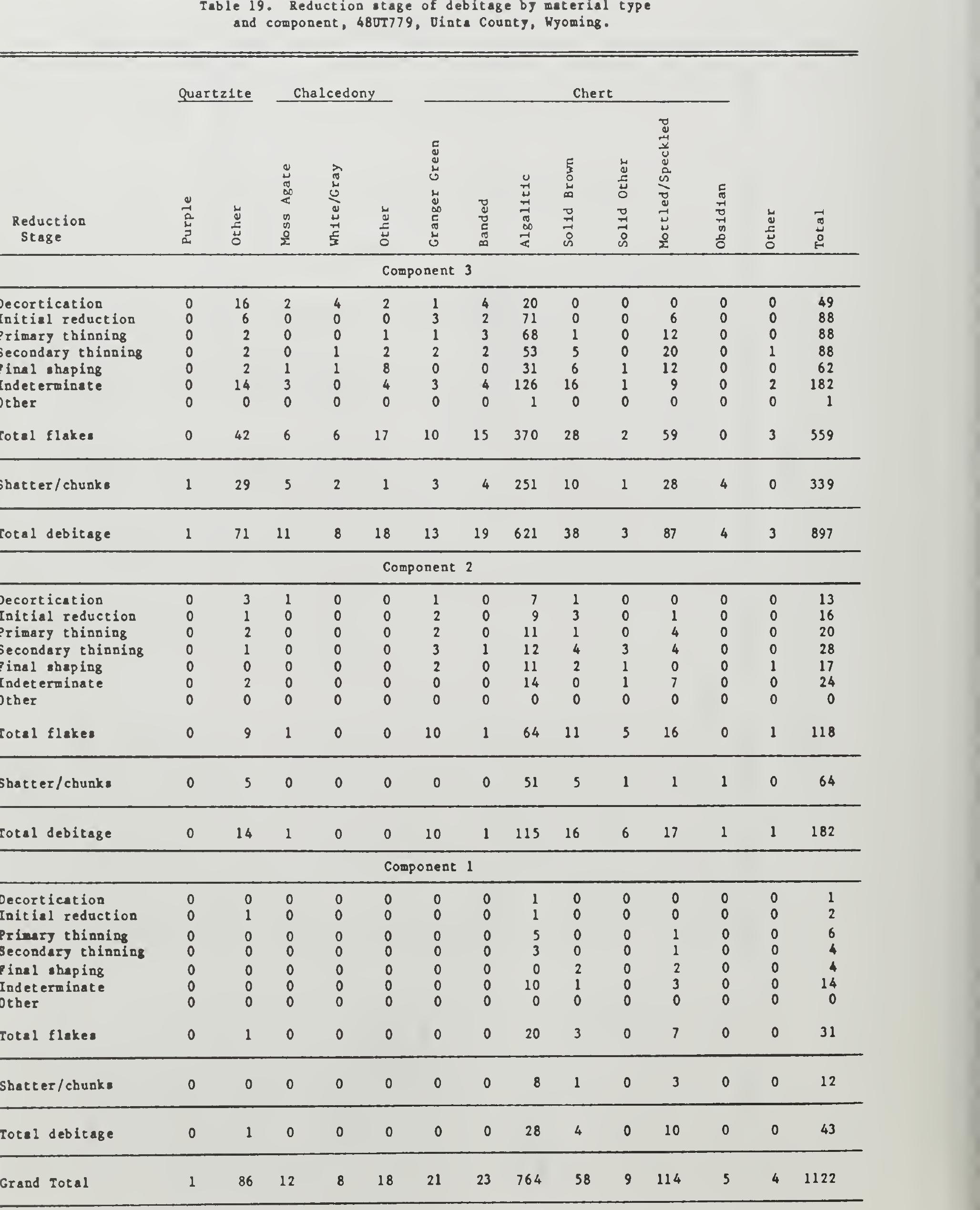
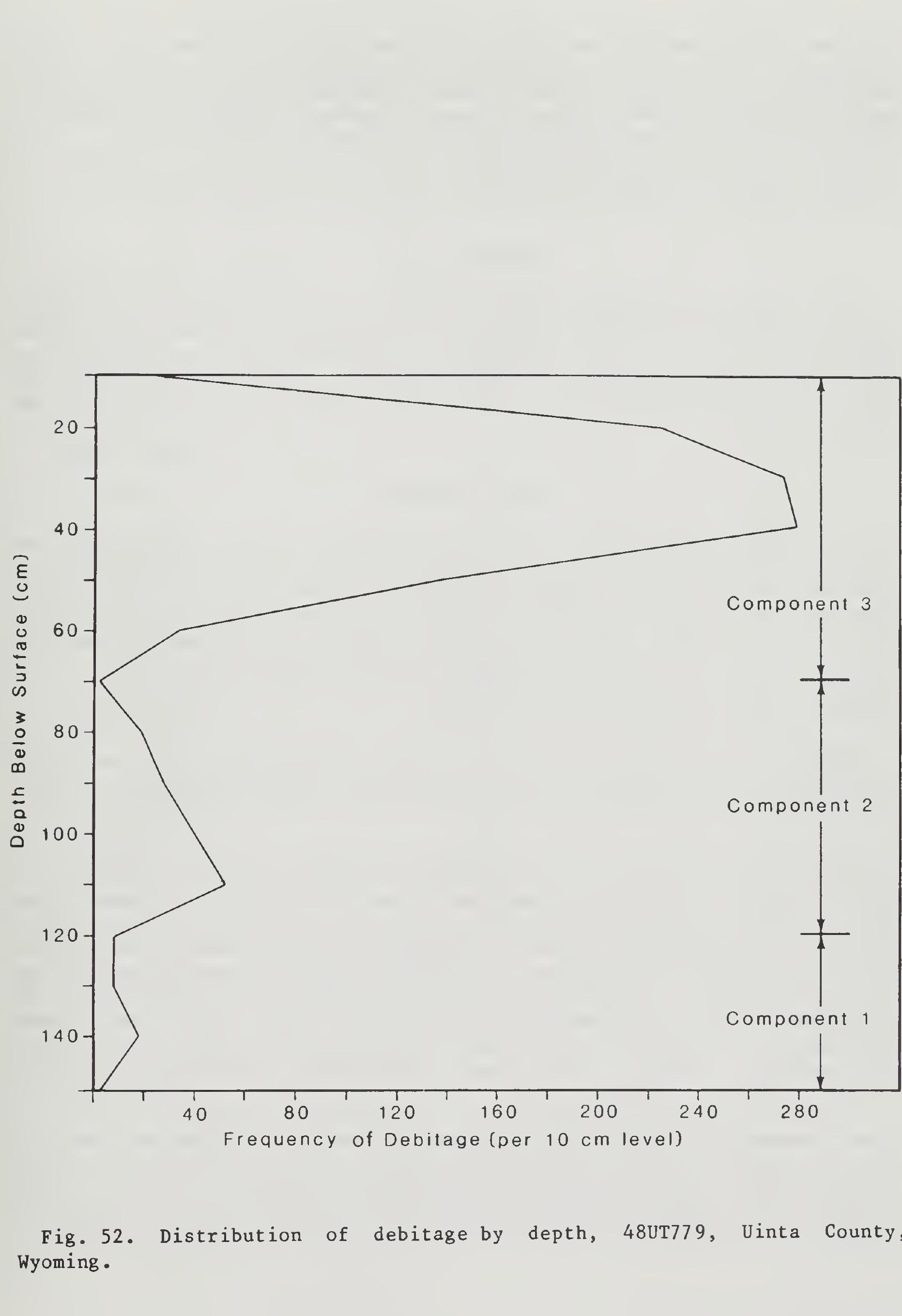
Cultural Component 2 was identified at about 60 cm below the present dunal surface. This component included 181 pieces of lithic debitage and 28 bone fragments. All stages of lithic reduction are represented in the debitage sample. No features were uncovered in this component, but a con- centrated area of thermally altered rock was noted. Diagnostic tools were also absent from the material collected from this component, no cultural affiliation or temporal association can be assigned to this component.
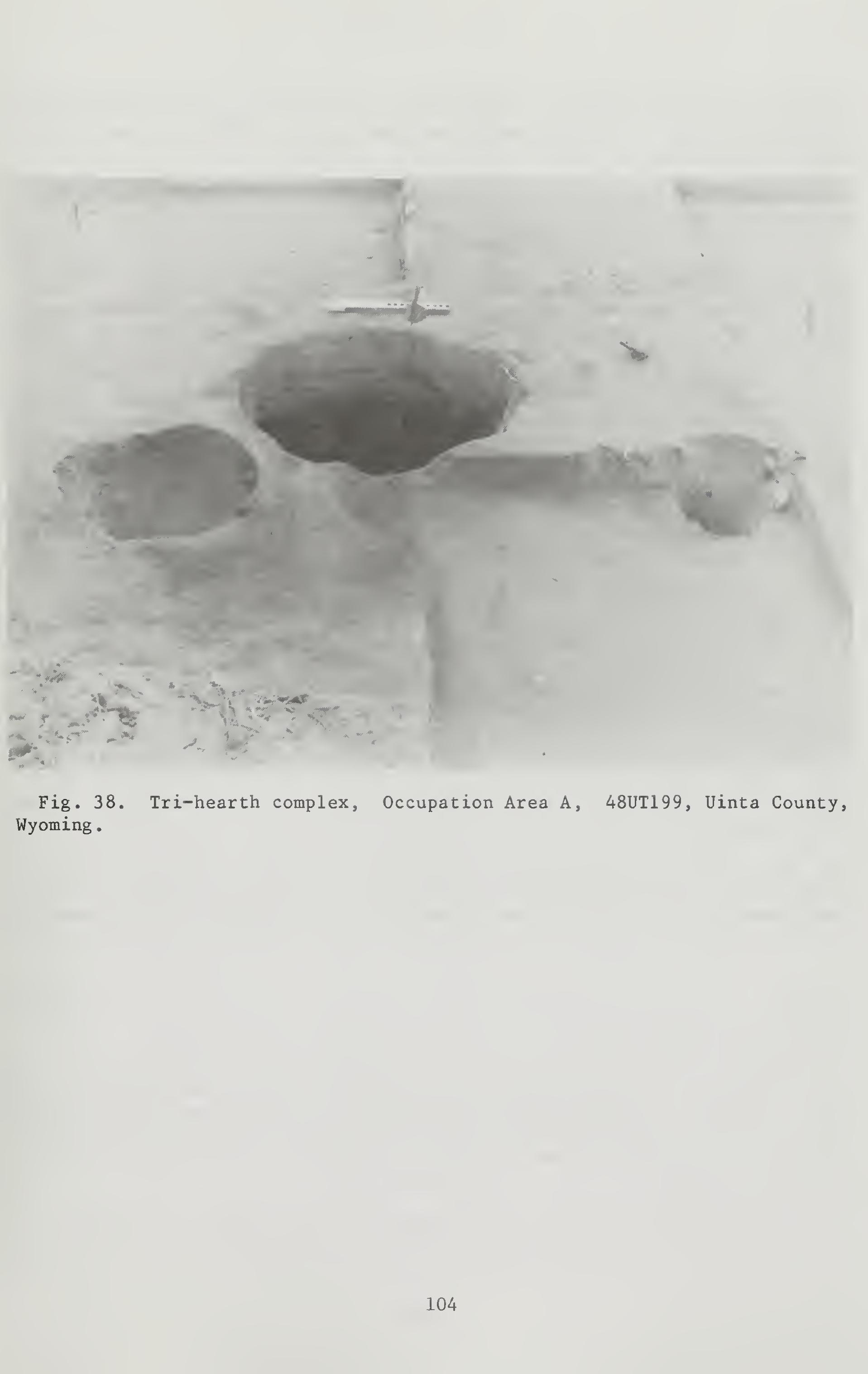
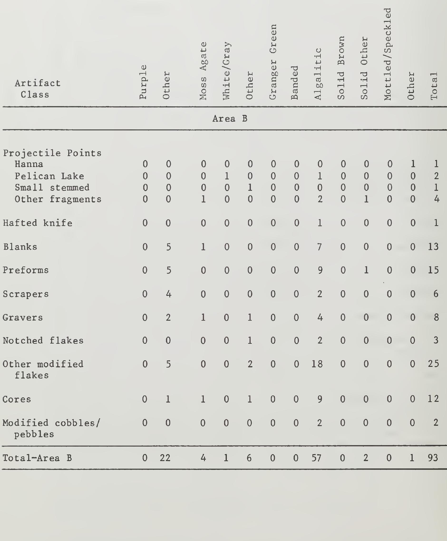
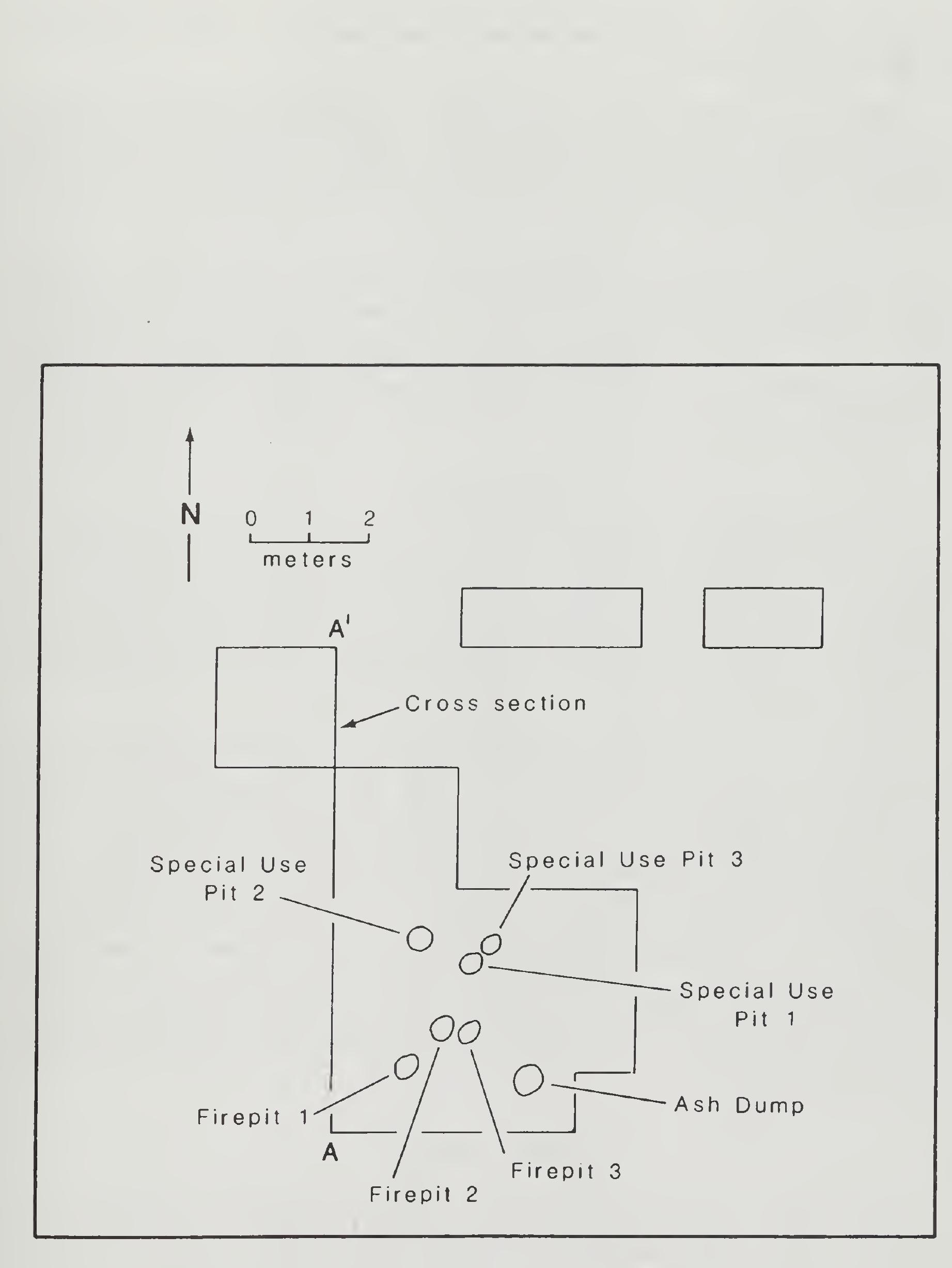
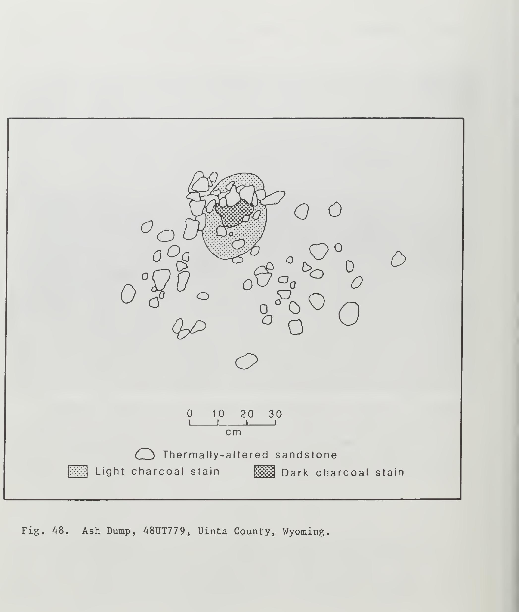
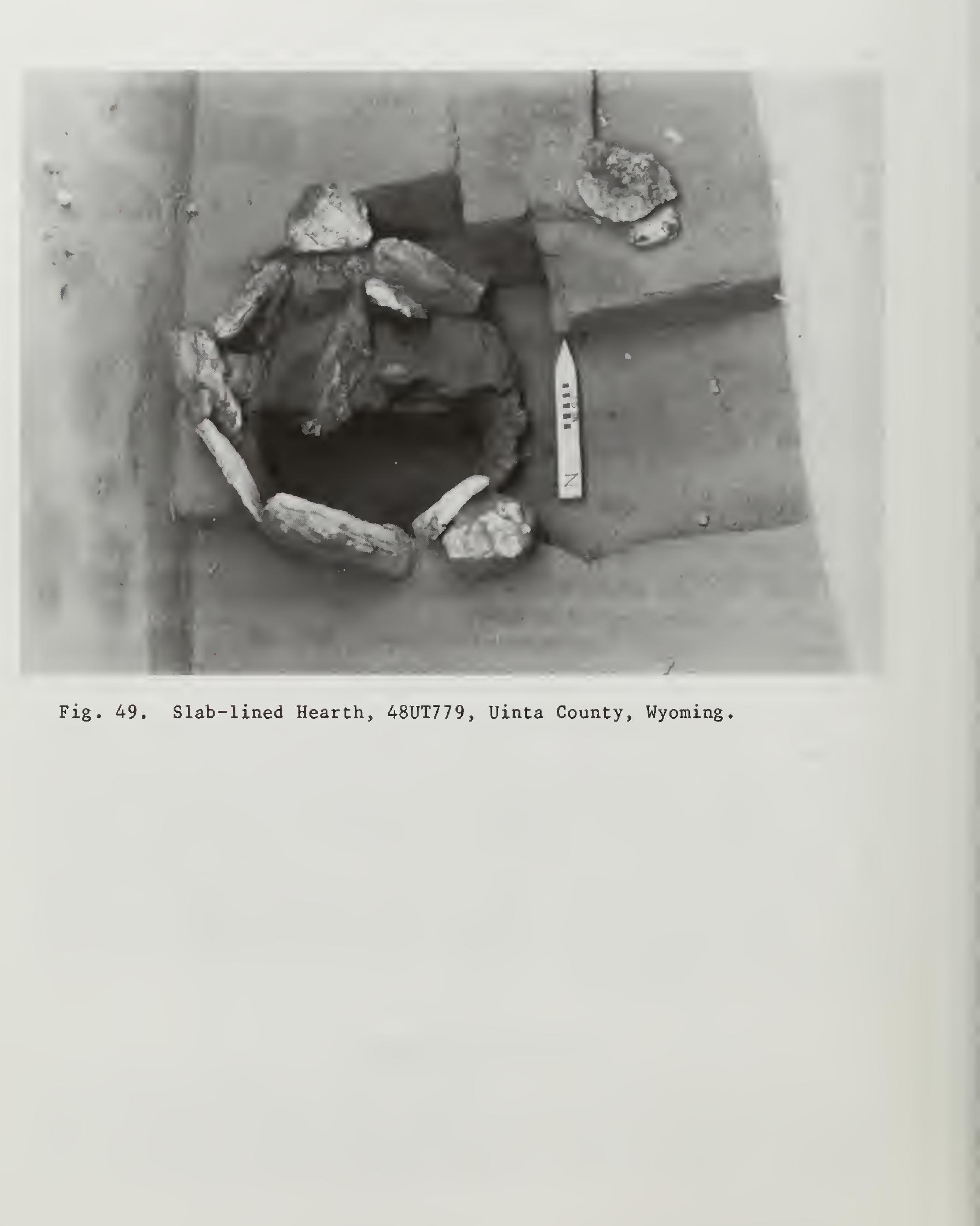
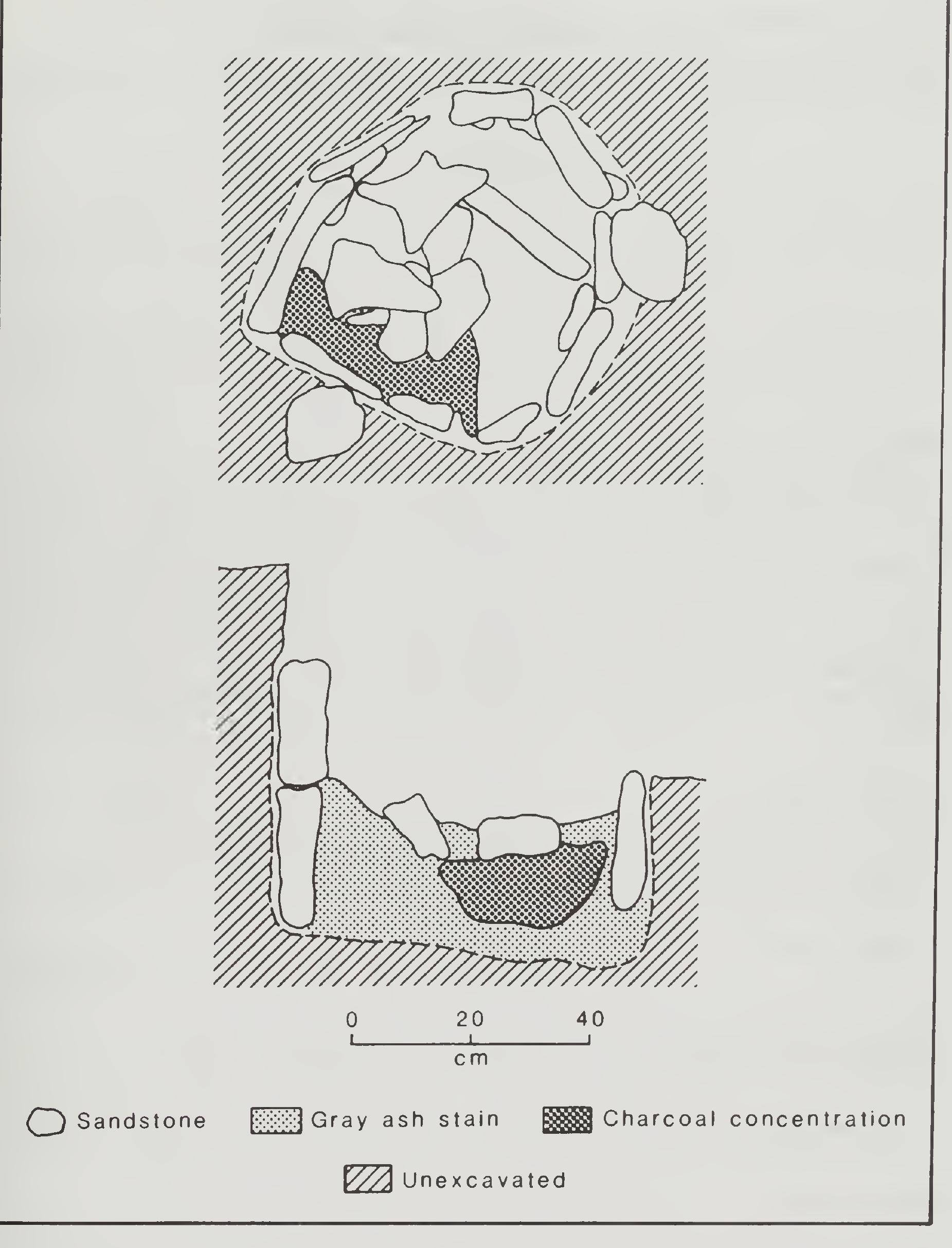
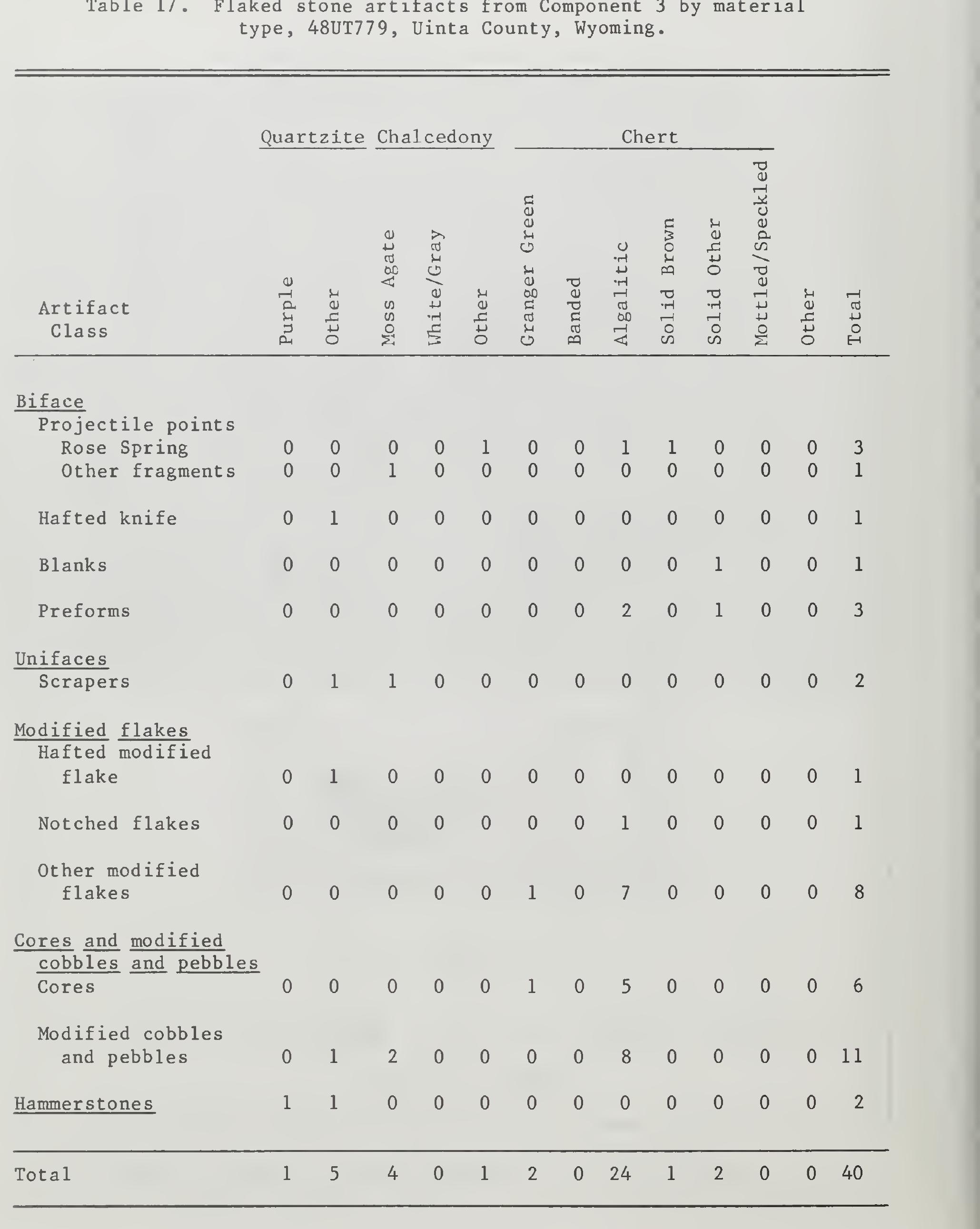
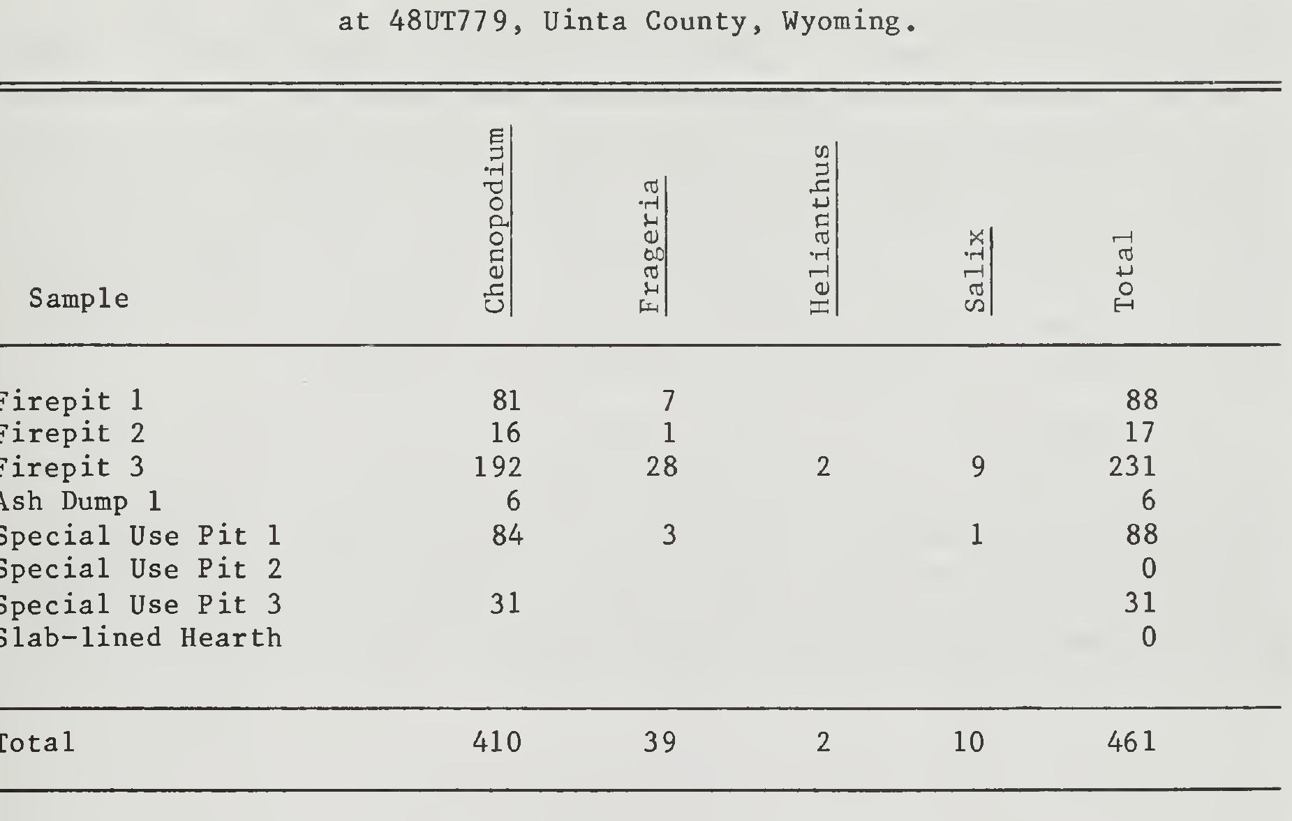
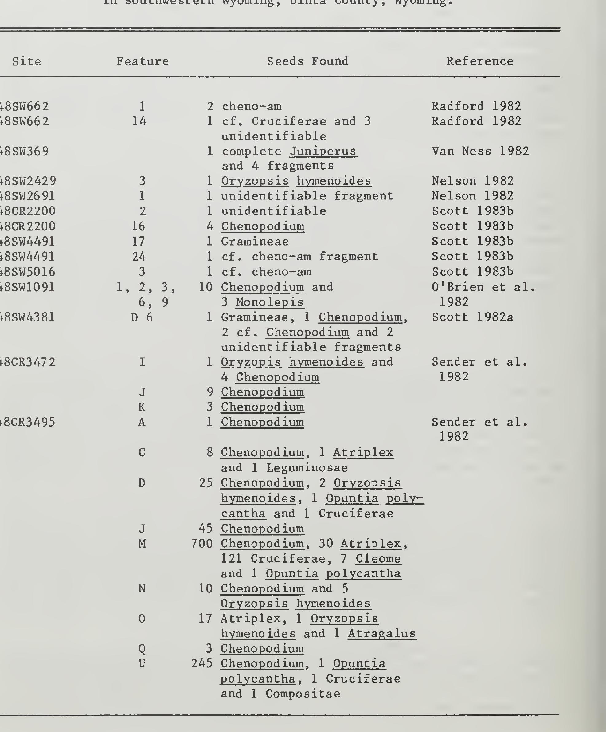
The distribution of cultural material around the firepits suggests that the hearths were periodically cleaned out and reused. The tool assemblage recovered from this component included cutting implements, as well as projectile points, indicating some food processing, in addition to lithic procurement and reduction, were taking place during the Late Prehis-— toric occupation at the site. The charred seeds from this site present the best evidence that Component 3 represents a short-term occupation with a balance hunting/gathering subsistence economy.
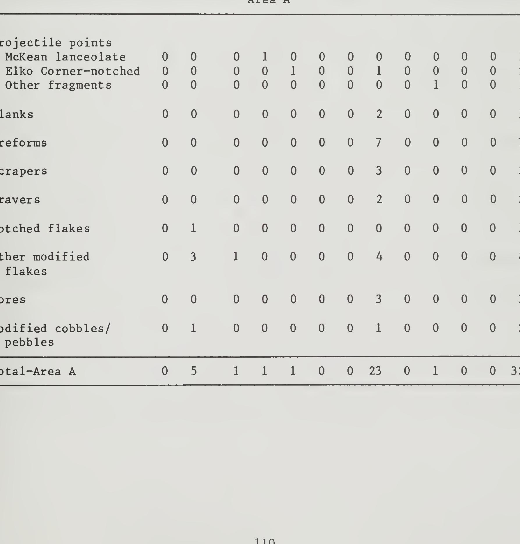
During a reinventory of the MAPCO pipeline, the site was mapped, collected and tested in October, 1980. Further work was recom- mended for the site, and in 1981 a crew returned to the site and conducted additional testing (Miller 1982). This additional testing resulted in the discovery of a buried Early Archaic activity area. relocated,
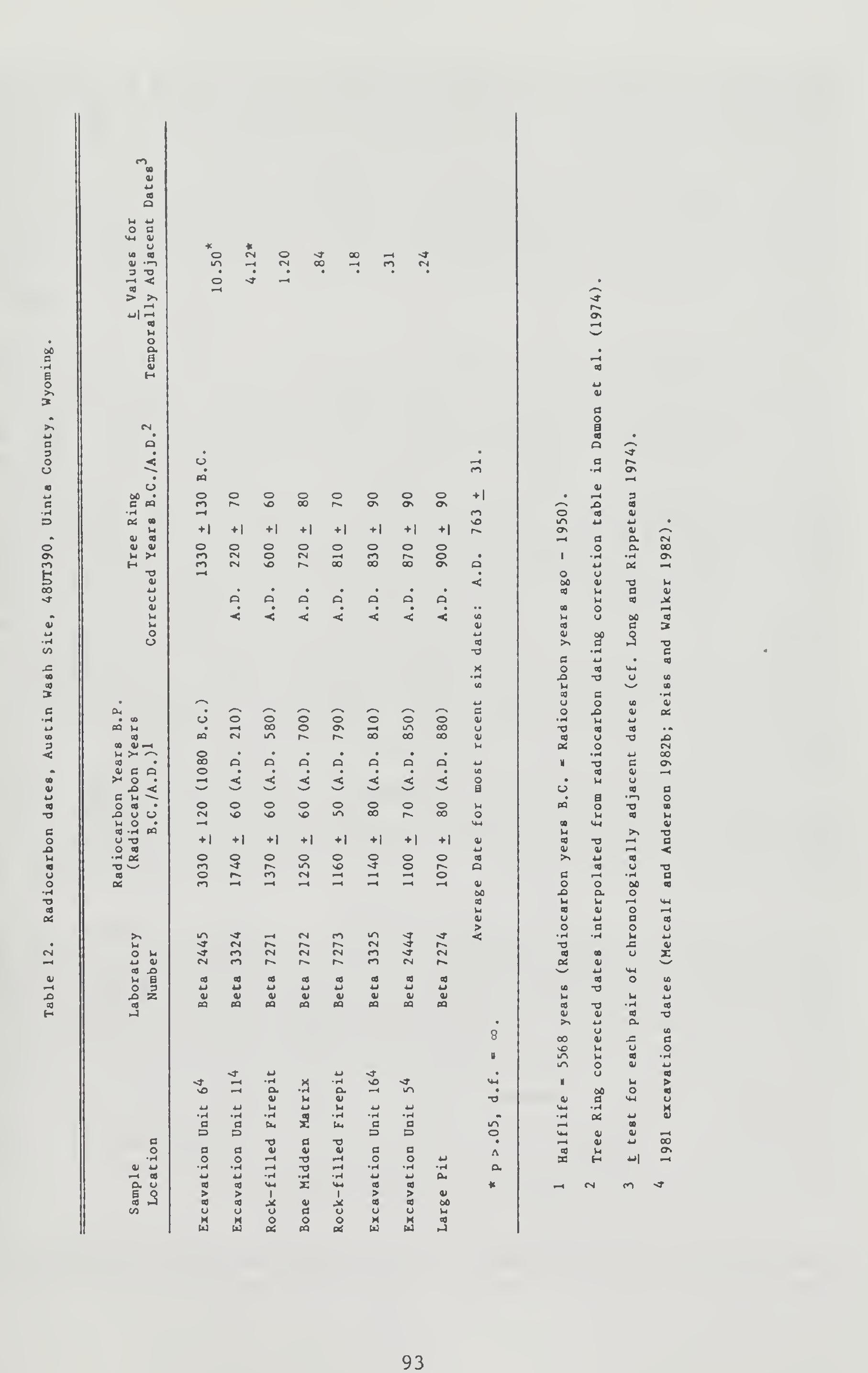
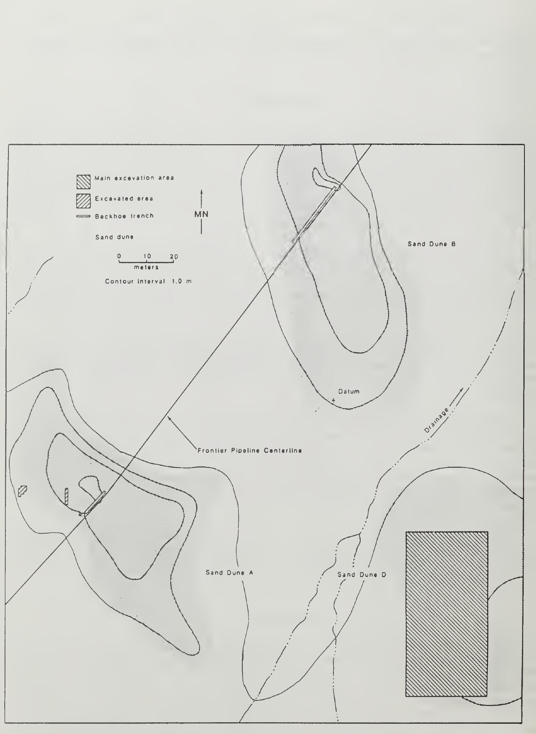
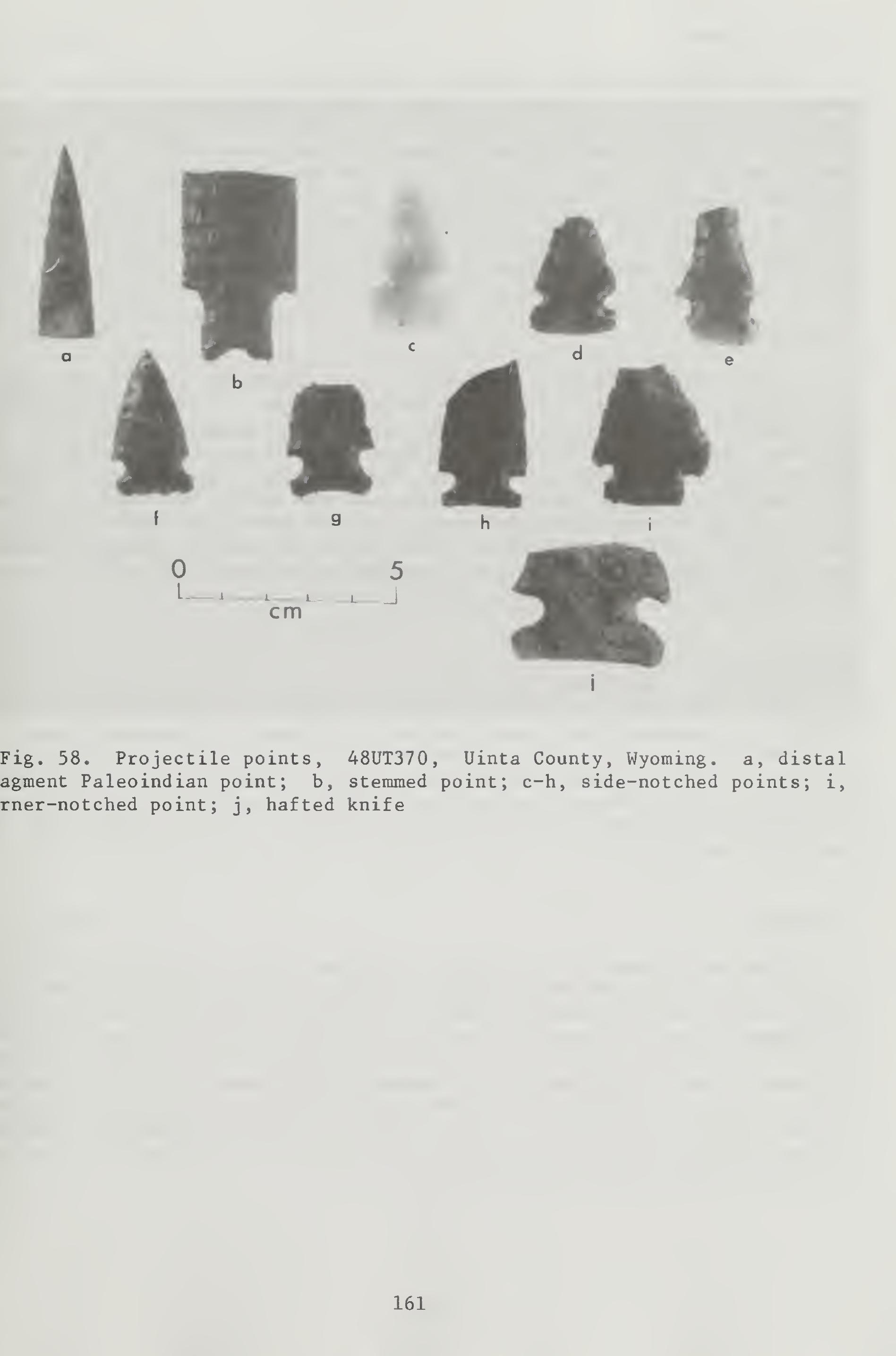
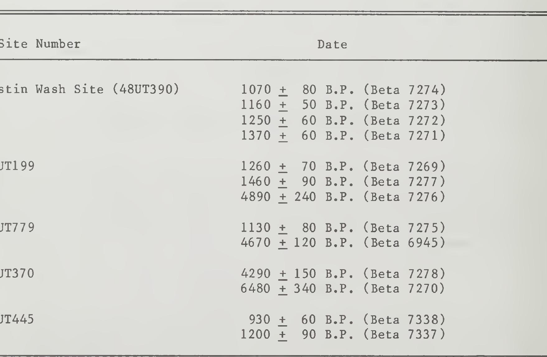
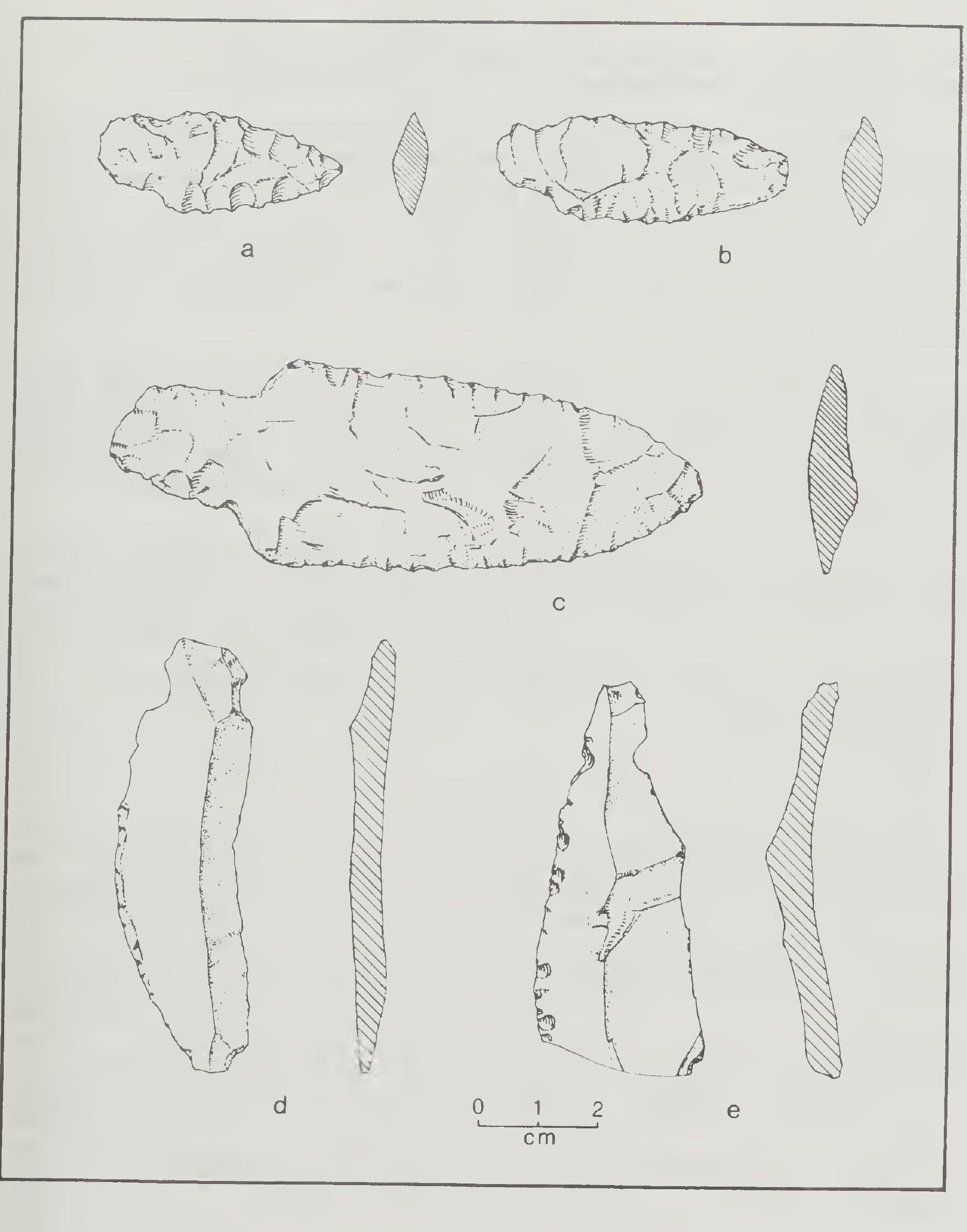
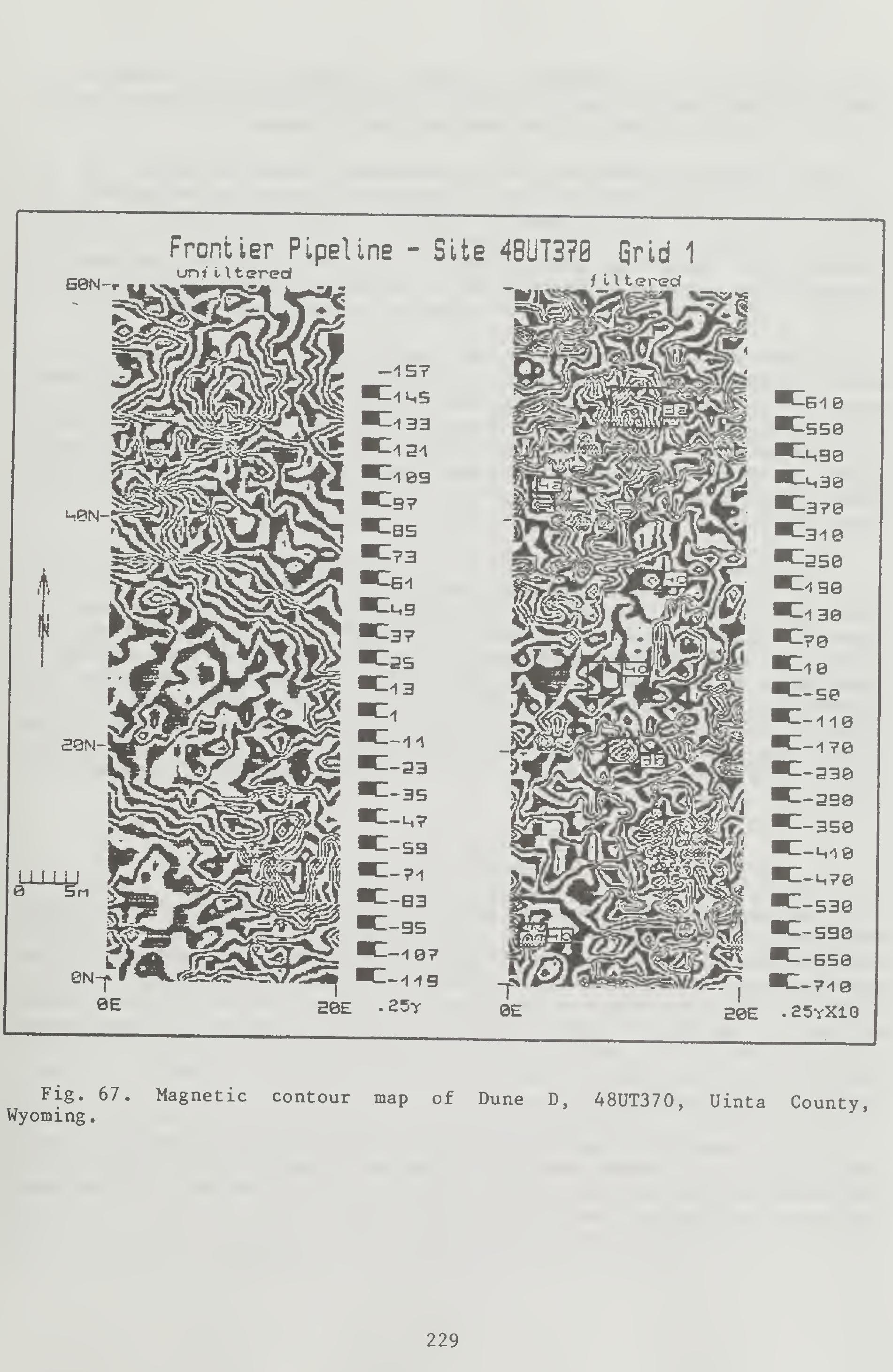
Two radiocarbon dates of 4530 and 3350 B.C. clearly place the occupa- tion excavated at Dune D in the Early Archaic period. While there is a great degree of variability in the projectile points recovered in this area, all are side-notched points which are generally considered diagnostic of the Early Archaic. The lack of ground stone and plant macrofossils implies that the site was something other than a plant processing site. The limited amount of faunal remains and the variation in debitage suggest that this area of the site represents an Early Archaic temporary field or hunting camp.
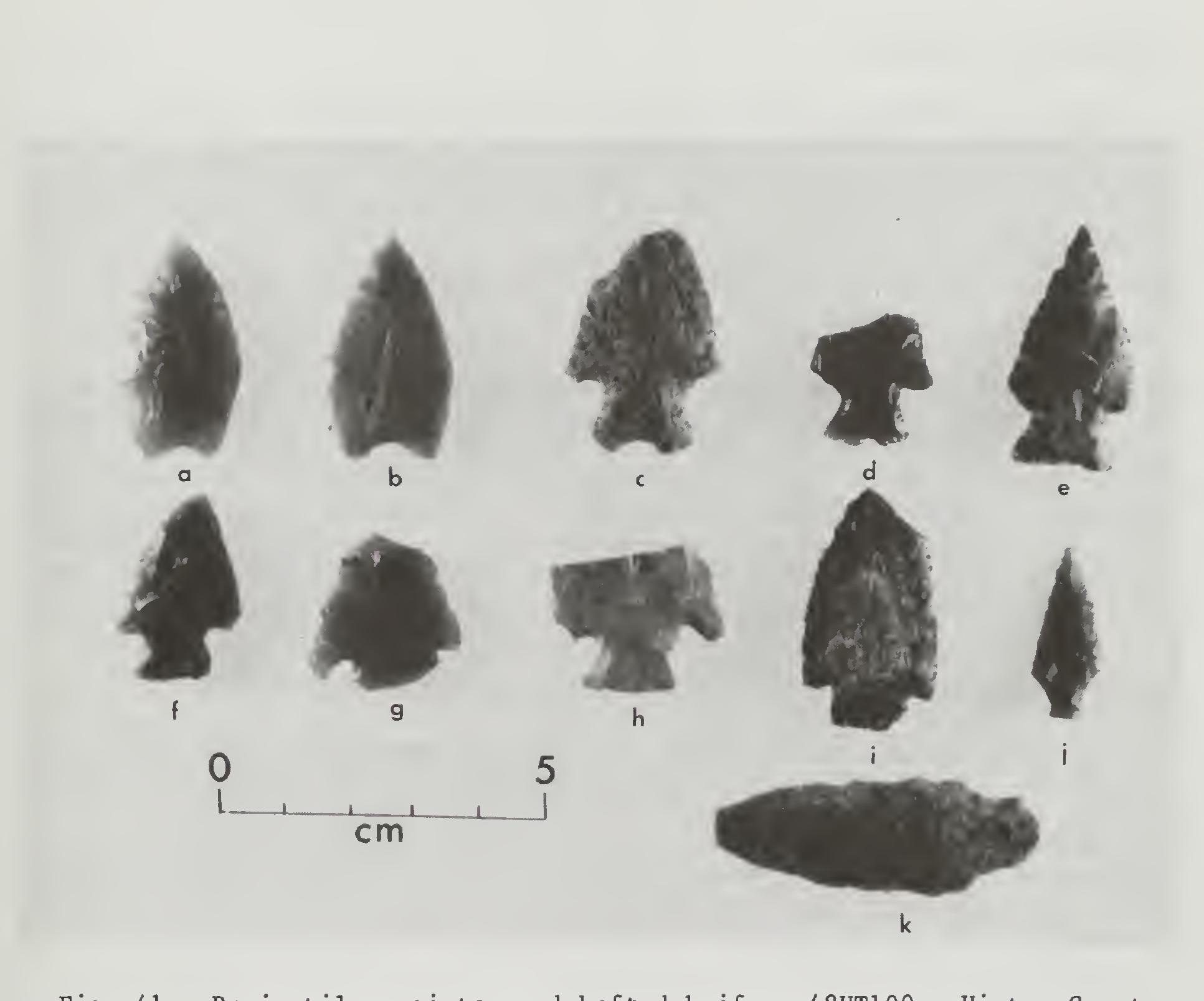
It appears that several point types that occur throughout the Great Basin, the intermountain area and the Northwest Plains have been given different names on the Northwest Plains and the Great Basin. For example, several side-notched point styles from Altithermal components have been variously referred to as Mummy Cave Side-notched or Pahaska Side-notched on the Northwest Plains. Morphologically similar points dating from the same time period are referred to as Northern Side-notched points in the Great Basin and Colorado Plateau. A similar situation exists with the San Rafael Side-notched point from the Colorado Plateau and the Mallory point from the Northwestern Plains.
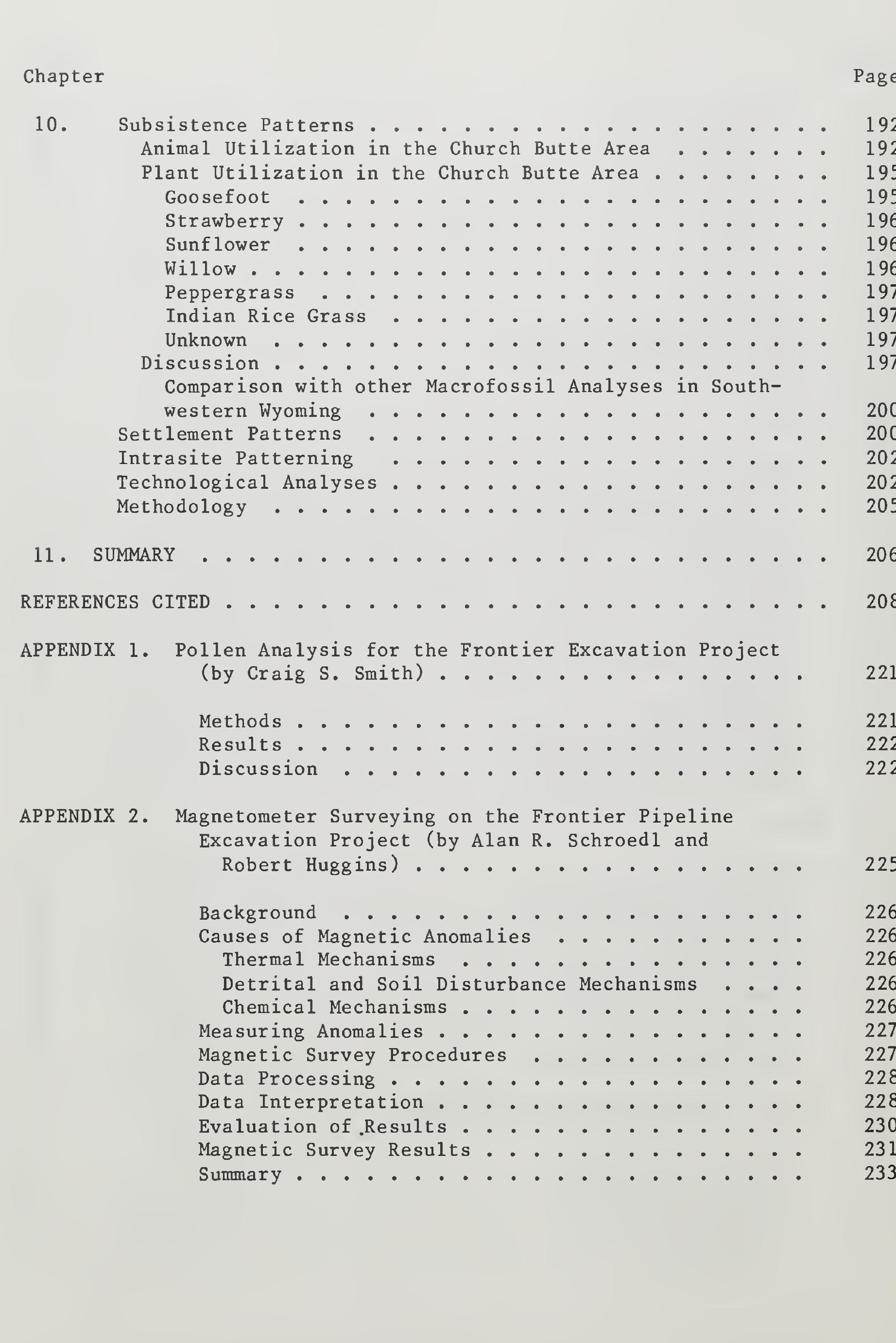
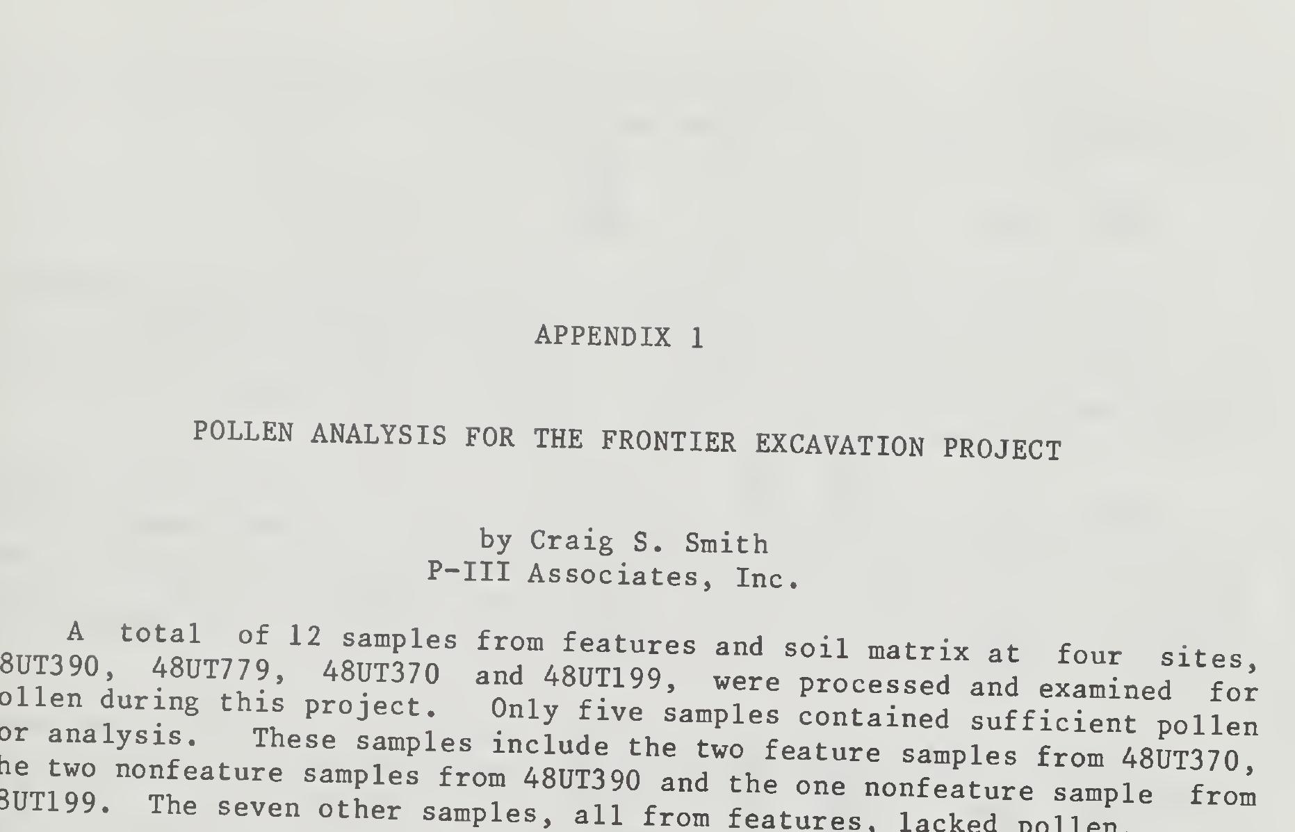
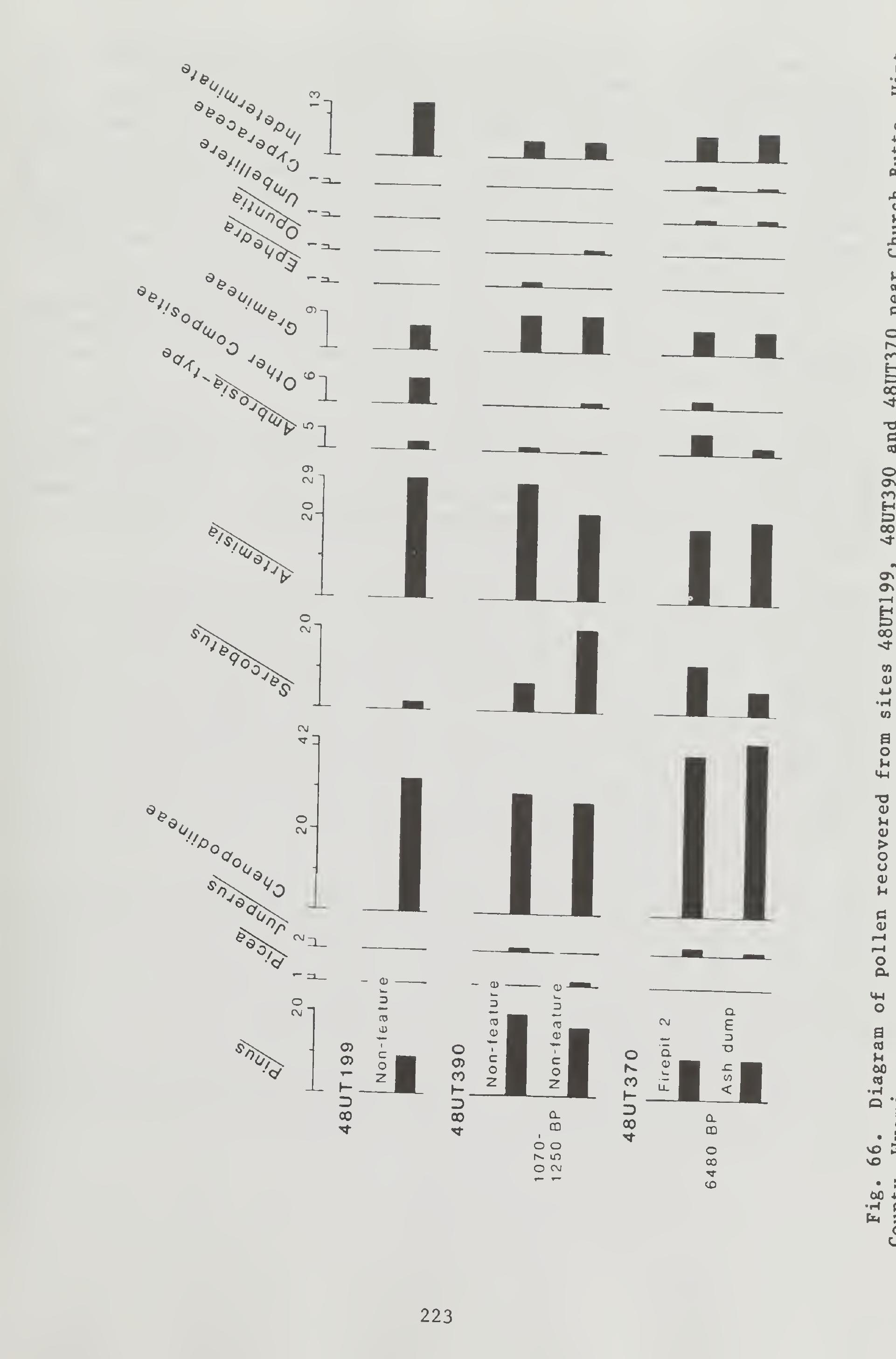
~ oo Sia’ ysSis was performed in the hope of producing information on the types of plants used by the prehistoric peoples of the araa, Unfortu- nately, due to limited number of samples containing pollen, few inferences and conclusions can be made. The noticeable differences in the relative frequencies of pollen types between samples could be the result of several Lactors . The analysis does show, however, that sufficient pollen can be obtained from eolian deposits in southwestern Wyoming. Nonfeature samples from within site areas, as well as samples from Stratigraphic columns, would probably provide valuable data. Because pollen appears to be poorly preserved in features, analyses of feature samples should focus on the recovery of plant macrofossil remains. Methods

Loading Preview
Sorry, preview is currently unavailable. You can download the paper by clicking the button above.
References (75)
- CITED Advisory Council on Historic Perservation 1980 Treatment of Archeological Properties: A Handbook.
- Aikens, C. Melvin 1970 Hogup Cave. University of Utah Anthropological Papers <n .
- Albee, Beverly J. 1980 68(l)Part 2:238-295, edited by J. Desmond Clark and F. Clark Howell.
- Blackstone, D. L., Jr. 1971 Traveler's Guide to the Geology of Wyoming. The Geological Survey of Wyoming Bulletin 55. Laramie.
- Bleacher, Joan M. 1982a Archaeological Investigations at 48SW662, 48SW663 . 48SW664 and 48SW3698 in the Leucite Hills Coal Mine Area Sweetwater County, Wyoming . Metcalf-Zier Archaeologists, Inc., Eagle, Colorado. 1982b Archaeological Investigations at 48SW2315. In Report on 1980
- Archaeological Site Testing for MAPCO 1 s Rocky Mountain Liquid Hydrocarbons Pipeline, Spread 6 , Lincoln, Sweetwater and Uinta Counties, Wyoming , edited by Michael D. Metcalf and Jane L. Anderson. Metcalf-Zier Archaeologists, Inc., Eagle, Colorado. Bohrer, Vorsila L. and Karen R. Adams 1977 Ethnobotanical Techniques and Approaches at Salmon Ruin, New Mexico. Eastern New Mexico University Contribution in Anthro- pology 8(1).
- Brown, Gary 1978a Archaeological Investigations on Colorado Interstate Gas Company Pipelines : Survey and Mitigation of CIG Extensions F58-8, F59- 6, F60-4, F61-4 and F63-4, Sweetwater and Carbon Counties, Wyoming . Archaeological Services-Western Wyoming College, Rock Springs. 1978b Archaeological Survey and Testing on the Stauffer Moxa Arch Pipeline: The Opal Bench Study Area, Lincoln County, Wyoming.
- Western Wyoming College Occasional Papers 16. 1978c Preliminary Report on the Archaeological Survey of the Stauffer Moxa Arch Pipeline, Lincoln County, Wyoming. Ms. on file, Archaeological Services-Western Wyoming College, Rock Springs. 1979 A Hunter-Gatherer Base Camp in the Upper Green River Basin. Ms. on file, Department of Anthropology, Arizona State University, Tempe . Brumley, John H. 1984 The Laidlaw Site: An Aboriginal Antelope Trap from Southeastern Alberta. Archaeological Survey of Alberta Occasional Paper 23:96-127.
- " Bryant, Richard 1982 Archaeological Investigations at 48UT445 (REW-105). In Report on 1980 Archaeological Site Testing and Evaluation for MAPCO ' s Rocky Mountain Liquid Hydrocarbons Pipeline, Spread 6 , Lincoln, Sweetwater and Uinta Counties, Wyoming , PMZ Archaeology, Eagle, Colorado.
- Bye, Robert A., Jr. 1972 Ethnobotany of the Southern Paiute Indians in the 1870s: With a Note on the Early Ethnobotanical Contributions of Dr. Edward Palmer. In Great Basin Cultural Ecology: A Symposium, edited by Don D. Fowler. Desert Research Institute Publications in the Social Sciences 8:87-104.
- Callahan, E. 1979 The Basics of Biface Knapping in the Eastern Fluted Point Tradi- tion -A Manual for Flintknappers and Lithic Analysts. Archaeo- logy of Eastern North America 7(1) : 1-180 .
- Cary, Merritt 1917 Life Zone Investigations in Wyoming, culture North American Fauna 42.
- U.S. Department of Agri- Chamberlin, Ralph V. 1911 The Ethno-Botany of the Gosiute Indians of Utah. Memoirs of the American Anthropological Association 2(5) :331-405.
- Collins, Susan M. and Calvin H. Jennings 1980 Preliminary Report-West Leg , Cultural Resource Inventory of Pipeline .
- Ms. on MAPCO' s Rocky Mountain Liquid Hydrocarbons U.S. Department of Interior, Bureau of Land Management file, Rock Springs, Wyoming.
- Coulam, Nancy J. and Peggy R. Barnett 1980 Paleoethnobotanical Analysis. In Sudden Shelter, by Jesse D. Jennings et al. University of Utah Anthropological Papers 103:171-196.
- Creasman, 1981 Steven D. Archaeological Investigations in the Canyon Pintado Historical District, Rio Blanco County, Colorado. Unpublished M.A. thesis, Colorado State University, Fort Collins.
- Creasman, Steven D. (editor) 1983 Altithermal Knife: A Diagnostic Altithermal Age Artifact. In 1982 End of the Year Report . Archaeological Services-Western Wyoming College, Rock Springs.
- Creasman, Steven D., Ted Hoefer, III, Janice C. Newberry, Thomas P. Reust, Douglas Kullen and Hugh R. Davidson 1983 Archaeological Monitor and Salvage Excavations Along the Trail- blazer Pipeline, Southern Wyoming. Western Wyoming College Cultural Resource Management Report 10. Archaeological Ser- vices-Western Wyoming College, Rock Springs.
- Damon, P.E., C. W. Ferguson, A. Long and E. I. Wallick 1974 Dendrochronologic Calibration of the Radiocarbon Time Scale. American Antiquity 39(2) :350-366
- Day, Kent C. and David S. Dibble 1963 Archaeological Survey of the Flaming Gorge Reservoir Area, Wyoming-Utah. University of Utah Anthropological Papers 65, Upper Colorado Series 9.
- Frison, George C. 1965 Spring Creek Cave, Wyoming. American Antiquity 31; 81-94.
- 1971 Shoshonean Antelope Procurement in the Upper Green River Basin, Wyoming. Plains Anthropologist 18(62) : 258-284.
- 1973 The Wardell Buffalo Trap, 48SU301 : Communal Procurement in the Green River Basin, Wyoming. Anthropological Papers of the Museum of Anthropology 48:1-111. University of Michigan, Ann Arbor. 1978 Prehistoric Hunters of the High Plains . Academic Press, New
- York. Fry, Gary F. 1976 Analysis of Prehistoric Coprolites from Utah. University of Utah Anthropological Papers 97
- Gardner, A. Dudley, Kathleen Harvey, Janice Newberry-Creasman, Douglas Kullen and Ted Hoefer 1982 The Paradox Ridge Site (48SW4381). Ms. on file, Archaeological Services-Western Wyoming College, Rock Springs.
- Gardner A. Dudley, Russell L. Tanner, Janice Newberry-Creasman, Roger Ward- low, James C. Mackey, Judy Jacobson, Jill Sail and Inis Pennella 1982 Archaeological Investigations Along the Kanda to Clay Basin Pipeline. Cultural Resource Management Report 2. Archaeologi- cal Services-Western Wyoming College, Rock Springs.
- Gilbert, B. Miles 1973 Mammalian Osteo-Archeology : North America . University of Mis- souri Press, Columbia.
- Gilmore, Melvin R. 1919 Uses of Plants by the Indians of the Missouri River Region. Annual Report of the Bureau of American Ethnology (1911- 1912)33:43-155.
- Gooding, John D. 1981 The Archaeology of Vail Pass Camp: A Multi-Component Base Camp Below Treelimit in the Southern Rockies. Highway Salvage Report 35. Colorado Department of Highways, Denver.
- Grayson, Donald K. 1979 On the Quantification of Vertebrate Archaeofaunas. In Advances in Archaeological Method and Theory 2:199-235. Academic Press New York.
- Greenhouse, Ruth, Robert E. Gasser and Jennifer W. Gish 1981 Cholla Bud Roasting Pits: An Ethnoarchaeological Example. Kiva 46(4): 227-242.
- Hakiel, Nicholas E. 1981 Results of Testing and Surface Collection of Site 48UT397 Due to Impaction by NWP R/W for Well Line to AMOCO Champlin #228 B-l Well Pad, Sweetwater County, Wyoming. Ms. on file, U.S. Depart- ment of Interior, Bureau of Land Management, Kemmerer Resource Area, Kemmerer, Wyoming.
- 1982 Testing of 48UT677, Final Report, Uinta County, Wyoming. Ms. on file, U.S. Department of Interior, Bureau of Land Manage ment, Kemmerer Resource Area, Kemmerer, Wyoming.
- Heiser, Charles B. 1951 The Sunflower Among the North American Indians. Proceedings of the American Philosophical Society 95(4) :432-448.
- Herron, James W. 1953 Study of Seed Production, Seed Identification and Seed Germina- tlon of Chenopodium spp. Cornell University. Agricultural Experiment Station Memoir 320.
- Hodder, Ian and Clive Orton 1976 Spatial Analysis in Archaeology . Cambridge University Press, Cambridge. Holmer, Richard N. 1978 A Mathematical Typology for Archaic Projectile Points of the Eastern Great Basin. Unpublished Ph.D. dissertation, Department of Anthropology, University of Utah, Salt Lake City. University Microfilms, Ann Arbor.
- Holmer, Richard N. and Dennis G. Weder 1980 Common Post-Archaic Projectile Points of the Fremont Area. In Fremont Perspectives, Antiquities Section Selected Papers 7(16) edited by David B. Madsen.
- Holmes, W. H. 1919 Handbook of Aboriginal American Antiquities, Part I. Bureau of American Ethnology Bulletin 60(1).
- Huggins, Robert 1981 Final Report of Magnetic Surveying Conducted on Black Mesa Arizona. Ms. on file, Center for Archaeological Investigations' Southern Illinois University, Carbondale.
- Wyoming , edited by Michael D. Metcalf and Jane L. Anderson. Metcalf-Zier Archaeologists, Inc., Eagle, Colorado.
- Metcalf, Michael D. et al. 1981 Archaeological Investigations at the Proposed South Haystack Mine, Uinta County, Wyoming , 1976-1977-1978 . Metcalf-Zier Archaeologists, Inc., Eagle, Colorado.
- Metcalf, Michael D. and Jane L. Anderson (editors) 1981 Report on 1980 Archaeological Site Testing and Evaluation for MAPCO 1 s Rocky Mountain Liquid Hydrocarbons Pipeline, Spread 6 , Lincoln, Sweetwater and Uinta Counties , Wyoming . Metcalf-Zier Archaeologists, Inc., Eagle, Colorado.
- 1982a Final Report on 1981 Investigations at Sites Along MAPCO' s Rocky Mountain Liquid Hydrocarbons Pipeline, Spread 6 , Lincoln, Sweet- water and Uinta Counties, Wyoming . Metcalf-Zier Archaeologists, Inc., Eagle, Colorado.
- 1982b Final Report on 1980 Archaeological Site Testing and Evaluation for MAPCO' s Rocky Mountain Liquid Hydrocarbons Pipeline, Spread 6 , Lincoln, Sweetwater and Uinta Counties, Wyoming . PMZ Archae- ology, Eagle, Colorado.
- Millar, J. F. V. 1981 Mortuary Practices of the Oxbow Complex. Canadian Journal of Archaeology 5:103-117.
- Miller, Sylvia 1982 Archaeological Investigations at 48UT370 (4330-53). In Final Report on 1981 Investigations at Sites Along MAPCO' s Rocky Mountain Liquid Hydrocarbons Pipeline, Spread 6 , Lincoln, Sweet- water and Uinta Counties, Wyoming , edited by Michael D. Metcalf and Jane L. Anderson. Metcalf-Zier Archaeologists, Inc., Eagle, Colorado. Minnis, Paul E. 1981 Seeds in Archaeological Sites: Sources and Some Interpretive Problems. American Antiquity 46(1) :143-152.
- Moss, John H. 1951 Glaciation in the Wind River Mountains and Its Relation to Early Man in the Eden Valley, Wyoming. University of Pennsylvania Museum Monographs 6:9-92.
- Moss, John H. , Kirk Bryan, G. William Holmes, Linton Satterthwaite, Jr., Henry P. Hansen, C. Bertrandschultz and W. D. Frankforter 1951 Early Man in the Eden Valley . University of Pennsylvania, Philadelphia. Mulloy, William T. 1958 A Preliminary Historical Outline for the Northwestern Plains. University of Wyoming Publications in Science 22(1) .
- Muto, G. R. 1971 A Technological Analysis of the Early Stages in the Manufacture of Lithic Artifacts.
- Unpublished M.A. thesis, Idaho State Uni- versity, Pocatello.
- Nelson, Shelli L. 1982 Flotation Analysis. In Report on 1980 Archaeological Site Testing and Evaluation for MAPCO ' s Rocky Mountain Liquid Hydro- carbon Pipeline, Spread 6 , Lincoln, Sweetwater and Uinta Coun- ties , Wyoming , edited by Michael D. Metcalf and Jane L. Anderson. Metcalf-Zier Archaeologists, Inc., Eagle, Colorado.
- Nelson, Shelli L. and Joan M. Bleacher 1981 West Leg Inventory. In An Archaeological Inventory of MAPCO 1
- s Rocky Mountain Liquid Hydrocarbons Pipelines , Spread 6 , Lincoln, Sweetwater and Uinta Counties , Wyoming , edited by Michael D. Metcalf and Jane L. Anderson. Metcalf-Zier Archaeologists, Inc., Eagle, Colorado.
- O'Brien, Patrick M. , James C. Mackey, Jill E. Sail and Keith Dueholm 1982 Floral Remains. In Archeological Investigations at 48SW1091 : A Stratified Plant Processing Site in Southwest Wyoming, by Patrick M. O'Brien. Cultural Resource Management Report 5:73-
- Archaeological Services-Western Wyoming College, Rock Springs.
- O'Brien, Patrick M. , A. Dudley Gardner, Judy A. Jacobson and Russell L. Tanner 1983 Archaeological Monitor and Salvage Excavations Along the MAPCO Wamsutter Extension Pipeline. Cultural Resource Management Report 8. Archaeological Services-Western Wyoming College, Rock Springs.
- O'Brien, Patrick M. , Russell L. Tanner, Judy A. Jacobson and Steven D. Creasman 1983 Results of the Class III Inventory for Chevron USA Phosphate Facility Plant Site, Rock Springs, Wyoming. Cultural Resource Management Report 9. Archaeological Services-Western Wyoming
- Olsen, Stanley J. 1960 Post-Cranial Skeletal Characters of Bison and Bos . Papers of the Peabody Museum of Archaeology and Ethnology 35(4).
- Oviatt, C. G. 1983 Frontier Pipeline Archeological Excavations: Geomorphology and Geologic Stratigraphy. Ms. submitted to P-III Associates, Inc., Salt Lake City.
- Palmer, E. L. 1878 Plants Used by the Indians of the United States. American Naturalist 12:593-606, 646-655.
- Radford, David S. 1982
- Appendix A. Flotation Analysis for Site 48SW1662, Leucite Hills Area of Southwestern Wyoming, Sweetwater County, Wyoming. In Archeological Investigations at 48SW662, 48SW663 , 48SW664, 48SW3698. In the Leucite Hills Mine Area, Sweetwater County, Wyoming, by Joan M. Bleacher.
- Ms. on file, Metcalf-Zier Archaeologists, Inc., Eagle, Colorado.
- Reiss, David and Paul Sanders 1982 Archeological Investigations at 48UT390 (4330-92). In Final Report on 1981 Investigations at Sites Along MAPCO ' s Rocky Mountain Liquid Hydrocarbons Pipeline, Spread 6 , Lincoln, Sweetwater and Uinta Counties , Wyoming , edited by Michael D. Metcalf and Jane L. Anderson. Metcalf-Zier Archaeologists, Inc., Eagle, Colorado.
- Reiss, David and Danny N. Walker 1982 Pronghorn Utilization at 48UT390 in Southwestern Wyoming. Wyoming Contributions to Anthropology 3
- The Archaic of the Northern Colorado Plateau. Unpublished Ph.D. dissertation, Department of Anthropology, University of Utah, Salt Lake City. University Microfilms, Ann Arbor.
- 1980 Cultural Resource Inventory: MAPCO ' s Rocky Mountain Liquid Hydrocarbons Pipeline. Utah . July. Woodward-Clyde " Consul- tants, San Francisco.
- Scott, Linda J. 1982a Appendix 1. Macrofloral Analysis at 48SW4381, Southwestern Wyoming. In The Paradox Ridge Site, by A. Dudley Gardner et al.
- Ms. on file, Archaeological Services-Western Wyoming College, Rock Springs. 1982b Appendix D. Pollen Analysis. In Final Report on 1981 Investi- gations at Sites Along MAPCO' s Rocky Mountain Liquid Hydrocar- bons Pipeline, Spread 6, Lincoln, Sweetwater and Uinta Counties, Wyoming. Ms. on file, Bureau of Land Management, Wyoming. 1983a Appendix A. Pollen and Macrofloral Analysis from 48CR1929, 48CR3961 and 48CR2962, Carbon County, Wyoming. In Archeological Monitor and Salvage Excavations Along the MAPCO Wamsutter Exten- sion Pipeline, by Patrick M. O'Brien. Cultural Resource Manage- ment Report 8:84-91. Archaeological Services-Western Wyoming
- College, Rock Springs. 1983b Appendix C. Pollen and Macrofloral Analysis of Sites Along the Trailblazer Pipeline in Southwestern Wyoming. In Archeological Monitor and Salvage Excavations Along the Trailblazer Pipeline, Southern Wyoming, by Steven D. Creasman. Cultural Resource Management Report 10(2): 41-57. Archaeological Services-Western Wyoming College, Rock Springs.
- Sender, Malcom, George Stilphen, James Schoen and Dennis Grasso 1982 Archaeological Investigations Along the AMOCO Wamsutter Liquid Condensate Collection System. Red Desert. Wyoming . High Plain Consultants, Laramie, Wyoming.
- Sharrock, Floyd W. 1966 Prehistoric Occupation Patterns in Southwest Wyoming and Cul- tural Relationships with the Great Basin and Plains Culture Areas. University of Utah Anthropological Papers 77.
- Smith, Anne M. 1974 Ethnography of the Northern Utes. Museum of New Mexico Papers in Anthropology 17. Spraque, Marshall 1964 The Great Gates: The Story, of the Rocky. Mountain Passes. Lit- tle Brown & Company, Boston.
- $t o& BLM-WY-PT-85-007-4331
