On the Lion Harbour and other Harbours in Miletos: recent historical, archaeological, sedimentological, and geophysical research (original) (raw)
2014, Proceedings of the Danish Institute at Athens 7, 2013, 49-103
Abstract
The Lion Harbour was Miletos’ most prominent harbour during antiquity. It can be envisaged as the heart of the Ionian metropolis in western Asia Minor. Originally situated in a bay of the “(I-)Karian Sea”, Miletos is now fully incorporated into the plain of the Maeander river, today’s Büyük Menderes. In this article we combine results from historical and archaeological research with those from palaeo-geography and geophysics. This geoarchaeological approach offers new insights into the dynamic evolution of the harbour basin from the time of the marine transgression in the early Bronze Age (c. 2500 BC), when the area formed part of an island, until its final siltation by the sediments of the river Maeander c. AD 1500. The Lion Harbour’s outstanding significance is clear from its strategic role as one of the closable war harbours of Archaic and later times. Its central position in the Archaic insula street grid, lining the agora and the main city sanctuary of Apollo Delphinios, made it a gate through which, so to speak, gods and humans entered the city; it was also the point from which Milesians left the city to start their sailing seasons or found their many colonies. The Lion Harbour is likely to be identified with the “Harbour of Dokimos” mentioned by the 1st century AD novelist Chariton (Chaireas and Kallirhoë 3.2.11) The commercial relevance of the Lion Harbour, however, was quite limited in antiquity. Miletos had a series of other harbours that fulfilled this function: the Theatre Harbour is perhaps the oldest of Miletos’ harbours; it also served as a closable harbour in Geometric-Archaic times. Other important harbours are the Humei Tepe Harbour and the Eastern Harbour at the eastern fringe of the peninsula; one of them, most probably the Eastern Harbour, should be identified with the emporion, or commercial harbour, where the slave market was located. Together, this quartet might be equated with the four harbours of the city Strabon mentions (Geographica 14.1.6). Finally, there are the Athena and Kalabak Tepe harbours, both of only minor importance. An overview of the evidence for all these harbours is given at the end of the article.
Figures (28)

Fig. 1. Miletos seen from the German excavation house in the south (Akkéy). The Hellenistic-Roman theatre with the Byzantine-Turkish castle on top is situated on Kale Tepe. The Lion Harbour lies in the natural depression between this little hill and the one to the right (Humei Tepe). The floodplain of the Biiyiik Menderes valley in the middle ground occupies the area of the former marine embayment (part of the “(I)Karian Sea”). The mountain chain of the Mykale is visible in the background. Photograph: H. Brickner (28 August 2010).

Fig. 2. The Lion Harbour (“Harbour of Dokimos”?) viewed from the Byzantine castle on Kale Tepe. Above: the seaward part of the harbour with the earth dam at its entrance; this was erected in 1984/85 against the regular flooding of the river Biiyiik Menderes (Maiandros, Maeander) and followed the presumed course of the ancient moles at the closable harbour entrance. Below: the landward part of the harbour is covered by excavation spoil. In the middle ground to the right: area of the Delphinion (sanctuary of Apollo Delphinios), the Selcuk Baths, and the so-called Ionian Hall (building with columns) at the Processional Road. Photographs: H. Briickner (1 October 2008).

Fig. 3. Aerial photograph of the Lion Harbour from NE. Kale Tepe with Byzantine-Turkish castle (1), Humei Tepe (2), Earth dam of 1984/s, blocking the harbour mouth from the Maeander plain (3), harbour area filled with excavation spoil (4), western end of the Harbour Hall with large Harbour Monument in front (5), Delphinion (6), Selcuk Bath (7), Har- bour Gate (8), Heroon I (of Dokimos?) (9), western lion (10), Turkish caravanserai (Han) (11), Roman baths (12), Turk- ish Derwish cloister (Tekke) (13). Photograph: E. Kiigiik (September 2011).

another famous Milesian sculpture, that of the so-called Kanachos-Apollo in Didyma (Fig. 8).8 Indeed, this very lion is depicted on some Milesian bronze coins of the 3“ to 1* centuries BC, together with

We learn from Strabon that Miletos had four harbours

Fig. 6. The Lion Harbour (“Harbour of Dokimos”?) viewed from the modern earth dam. The excursion group is standing around the weathered and broken statue of the western lion. In the middle ground, the bushy vegetation marks the spoil that earlier excavations had dumped into the silted up, but still swampy harbour basin. In the far background is the escarp- ment of the limestone plateau of the Stefania (the ancient Akron). Photograph: H. Briickner (1 October 2008).

A brief history of Miletos and its dynamic palaeogeo- graphy in relation to its harbours is compiled in Table 1. The palaeogeographic evolution of the Milesian Peninsula (H.B., A.H. & M.M.)


A summary of these findings leads to the conclusion that the transformation from archipelago to peninsula started around 1900 BC. Several corings around the Tem- ple of Athena reveal the siltation process and the gradual changeover from shallow marine to coastal and finally ter- restrial conditions.” A slight marine regression, together with the natural and human-induced areal denudation and accumulation processes described above, contributed to A summary of these findings leads to the conclusion ple of Athena reveal the siltation process and the gradual accumulation processes described above, contributed to


Fig. 1. Progradation of the Maeander Delta from 1500 BC until today. Source: modified after Miillenhoff 2005, 214 fig. 56.

Fig. 12. The Milesian Peninsula on Google Earth. Even after the total siltation of the area, the former peninsula can still be identified: its barren rock is in great contrast to the irrigated green fields of the Maeander floodplain that used to be part of the “(I)Karian Sea” in Greco-Roman times. The satellite image also shows the hilly hinterland and the meandering river course (nomen est omen). View towards SSW with the Aegean Sea in the background. L = Lion Harbour. Source: © Google 2013, date: 16 July 2008, altitude: 1010 m.

Fig. 13. Lion Harbour (“Harbour of Dokimos”?) showing the course of the detected quay wall (“hell. Hafenmauer’, blue line), and modern position of the Harbour Lions (blue circles). Ancient and Medieval buildings in red. Note Heroon I (= “Heroon (hell.)”) next to the Byzantine castle on top of the theatre, presumably the heroon of Dokimos and the phrourion of Tissaphernes/Asandros. Source: modified after Bendt 1968: Nordblatt (section).

Fig. 14. Reconstruction of the inner part of the Lion Harbour (“Harbour of Dokimos”?) in the later Roman period (c. AD 200), with the Harbour Gate, Harbour Hall, and the larger Harbour Monument seen from the north. Note the beach in front of the quay, which is supposed to indicate the ongoing siltation of the harbour. The quay on the eastern side of the harbour is not detected by excavations. This is where the shipsheds (neoria) are presumed to have been located. Model of the Pergamon Museum in Berlin, by K. Stephanowitz 1968, after a model made by H. Schleif c. 1930, lost in WW II. Photo- graph: S. Gribener (April 2003).

case, for example, at the harbour of Samos in the time of Polykrates (before 528 BC),’5 or in the 5" century BC har- bours of Sicilian Naxos and the Zea Harbour of Athens, a quay wall is missing in front of the shipsheds.’° According to Herodotos (6.8.1), Miletos was able to supply 80 triremes in the battle of Lade in 494 BC, even without following the proposal of Hekataios to make use of the treasures of the quay wall is missing in front of the shipsheds.’° According proposal of Hekataios to make use of the treasures of the

Fig. 16. Humei Tepe and the Lion Harbour with topographical relief and superimposed magnetic map (dark and light are positive and negative anomalies, respectively). Red: ancient buildings, yellow: assumed course of the sea wall and closing mole at the harbour mouth. Source: modified after Rabbel et al. 2006, 211 fig. 4.

Fig.17. Seismic measurements at the western Harbour

The chronostratigraphy of the sedimentation process, The chronostratigraphy of the sedimentation process, based on several '#C age estimates and diagnostic ceramic fragments, reveals considerable morphodynamic chang- es. The very low sedimentation rate between 3960-3790 BC and 510-390 BC, i.e. from the Neolithic/ Chalcolithic until the Archaic periods, of only 0.6 mm/a, is evidence ofa still intact ecosystem with a low sediment flux in the environs of the Lion Harbour. Thereafter, the sedimen- tation rate increases to 6.3 mm/a between 510-390 BC and 100-50 BC, i.e. during the Classical and Hellenistic periods, which documents the mobilisation of sediments from the adjacent slopes. The highest sedimentation rate is reached in Roman and early Byzantine times: 12.2 mm/a between 100-50 BC and c. AD 400. This can be explained by the increased human impact on the eco- system in Roman times.’ The same holds true for Lake

quickly. The processed data and any kind of anomalies have to be interpreted. The second step is to verify or fal- sify these interpretations. In many cases this can be done by coring, which is a relatively quick and inexpensive method, causing nearly no damage to the subterranean structures; it is a kind of “minimally invasive” archaeology. The third step is to carry out excavations — the most pre- cise method, but also the most costly and time consuming one; in areas where the groundwater table is high, e.g. in coastal or alluvial archives, excavation is only possible with an expensive well-point system. quickly. The processed data and any kind of anomalies

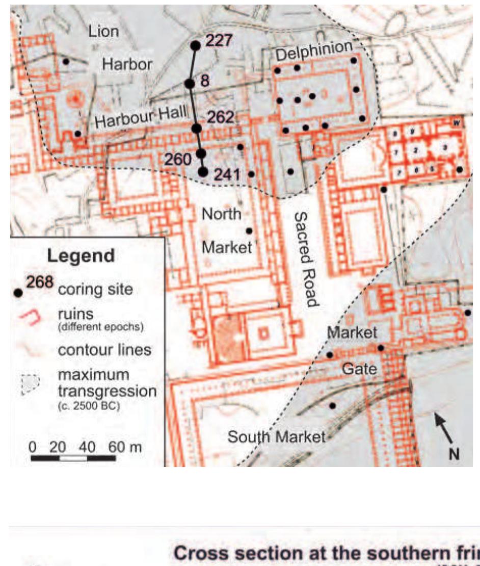
Table 2. Depth of the soft rock/hard rock contact based on geophysical data (“migrated depth”) and coring evidence (“drilled depth”) from nine coring sites of the Lion Harbour. For the coring sites, see Fig. 20.

Fig. 20. Magnetic, seismic, and geoarchaeological investigation in the Lion Harbour. Left: magnetic map of northern har- bour basin. L = present-day position of the lion statues. Dashed red frame = area of 3D seismic measurements; red circles: locations of nine corings for ground truthing of the seismic measurements (cf. Tab. 2). Right: in colour: final topographic model of the basement derived from 3D seismic refraction data (view from NW); black vertical lines: coring hole positions, diamond markers indicate the surface and cored bedrock depths, respectively; grey scale map on top: cut-out from the mag- netic map. The dashed red frames and red circles of the left and right figures correspond to each other. Source: modified after Woelz et al. 2009, fig. 5.20.


Fig. 22. Magnetic and seismic investigation in the Lion Harbour. Dark grey are positive, light grey are negative anomalies. The thickness of the Holocene filling of the harbour basin is based on 2D and 3D seismic refraction data; drilling locations indicated by stars. 3D data was acquired in the framed area around anomaly B. Note that the absolute depths of the 2D and 3D measurements deviate from each other at the frame. Anomaly “F” marks assumed ancient mole to close the har- bour. Anomalies “A’ and “B” most probably belong to the early Byzantine brick constructions, anomalies “C” — “E” proba- bly to the so-called Gotenmauer (wall built against the invasion of the Goths in c. AD 262). Source: compiled after Stiimpel et al. 1999, 91 fig. 2, Woelz 2003, 20, and Woelz et al. 2009.

he images of the gods and their other movables; and on my Fig. 24. Cross-section at the southern fringe of the Lion Harbour embayment (see Fig. 23 for location). Source: modified after Miillenhoff et al. 2009a, 101 fig. 3. to leave the city. They departed for Miletos, taking with them vast swarms bred in the lake until the inhabitants were forced

large merchant(?) ships with three masts (18'"/19"" century

Fig. 26. Former Theatre Bay, view from the Roman cavea to the SW. In the foreground Turkish caravanserai (Han) (1). In the middle ground: entrance to Geometric-Classical Theatre Harbour (2), Athena Temple Island consisting of Stadion Hill (3) and the area around the Athena temple (4), Athena Harbour (5), Heroon II Island (6). The new Miletos Museum is visible to the left (7). In the background: Kalabak Tepe (“Burdock Hill”) (8) and Kalabak Tepe Harbour (9), Degirmen Tepe (“Windmill Hill”) (10), Zeytin Tepe (“Olive Hill”) with sanctuary of Aphrodite “in Oikous” on top (11), and German excavation house (12). Photograph H. Briickner (August 2010).

Fig. 27. Aerial view of the city centre of Miletos from the NE. In the foreground: Humei Tepe (1), Lion Harbour (2) and Kale Tepe (3). In the middle ground: North Market (4), Maeander with modern dam to the west (5), area of East Har- bour (6), South Market (7), Ilyas Bey Mosque (AD 1404) (8), Roman Faustina Baths in the area of the former Theatre Harbour (9). In the background: modern village of Balat (since 1955) (10). Photograph: E. Kiigiik (September 2011).

Loading Preview
Sorry, preview is currently unavailable. You can download the paper by clicking the button above.
References (229)
- "Afterwards follows the Latmian Gulf, at which is located 'Herakleia under Latmos', a small city with an anchorage. " (ἑξῆς δ' ἐστὶν ὁ Λατμικὸς κόλπος, ἐν ᾧ Ἡράκλεια ἡ ὑπὸ Λάτμῳ λεγομένη, πολίχνιον ὑφορμον ἐχον·). The bay of the Maeander mouth (Strabon 14.1.9, 12: ἐκβολάς τοῦ Μαιάνδρου) was instead part of the "Karian (or Ikarian) Sea": Herda 2009, 43-4 n. 106, 45 fig. 3.
- Chaireas and Kallirhoë 3.2.11; see below, § 3.1.
- Schröder et al. 1995, 239.
- Cf. Kekule von Stradonitz 1900, 106; Wiegand 1970, 42 (letter dated 15 October 1899);
- Wiegand 1901, 197: "Diese von den milesischen Münzen her bekannten Wappentiere der Stadt hüteten die Einfahrt des Hafens, ganz wie der bayrische Löwe die Einfahrt in den Hafen von Lindau. Der Kürze halber haben wir der ganzen Gegend den Namen 'Löwenbucht' gegeben. "
- von Graeve 1996, 317 with n. 2. The famous marble lion from a monumental tomb near Knidos of c. 350-200 BC, now in the British Museum, GR 1859.12-26.24 (Sculpture 1350), is only 3 m long and 2 m high, weighing some six tons: http://www.britishmuseum.org/explore/highlights/high- light_objects/gr/c/colossal_marble_lion.aspx [accessed 7 January 2013].
- 7 Seltman 1955, 28 pl. II 1; Deppert-Lippitz 1984, 15-6.
- Ehrhardt 1988, 132; von Graeve 1996, 317; Senff 2006, 269.
- Wiegand 1901: 197 fig. 6; for both lions see Kleiner 1968, 6-7, figs. 6-7; Kleine 1980, 61-2 fig. 25; von Graeve 1996. 11 Measurements and calculation of the lion's weight according to B.F. Weber: von Graeve 1996, 317 n. 3, 320 n. 7.
- Herrmann 1997, 9-11, 197 no. 188. The inscription is badly preserved, and some parts are missing, including the beginnings of lines 1-5. We follow the reconstruction of lines 3-7 by W. Crönert, (SEG I, 425); reprinted and translated into German by Herrmann 1997, 197, as well as the reconstruction of lines 8-9 by A. Rehm, reprinted by Herrmann 1997, 10 and translated into German, Herrmann 1997, 197. For the office of the epimeletes as "inspec- tor" of the Lion Harbour see Kawerau & Rehm 1914, 307-12; Herrmann 1997, 174 on no. 140.31-2, 46-7, 60-1, a treaty between Miletos and Kretan cities of 260-220 BC, mentioning ἐπιμεληταὶ τοῦ ἐμπορίου, "inspectors of the commercial harbour"; see below, § 4.6. the Turkish emirate of Menteşe conquered Palatia from the Byzantine Greeks in the early 14 th century AD, they named the place "Balat", after "Pa- latia" (Wiegand 1929, 15; Wittek 1934, 70, 130; P. Wittek in Wulzinger et al. 1935, 1; Kleiner 1968, 1, 140-1 fig. 108).
- For Humei Tepe = "Typhoid Hill", see Wulzinger et al. 1935, 39 and Greaves 2002, 148 (Turkish humma designating "any kind of high-fever, includ- ing that associated with malaria and typhoid"). This designation hints at the health problems caused by the extremely humid climate in the flooded Maeander plain, where diseases like malaria were common (Wiegand & Schrader 1904, 11-2; Wiegand 1929, 14-5; Philippson 1936, 9; Thonemann 2011, 18, 299). This fact prompted Th. Wiegand to place the excavation house some 5 km away from the dig, on a 134 m high hill close to the village of Akköy (Wiegand 1970, 41: letter dated 28 September 1899).
- Müllenhoff 2005, see the summary on pages 187-215 with figs. 48-56.
- Herda et al. forthcoming.
- Herda 2006, 10 lines 28-9 (so-called Molpoi Inscription, Hellenistic copy of a late Archaic sacred law, mentioning the course of the Milesian New Year's procession to Didyma via the Akron), 261-5 figs. 9, 17.
- Wiegand 1929, 3 fig. 4, 10 fig. 9, Beilage; Kleiner 1968, 1-3 figs. 2-3.
- Schröder 1990, 64-7 figs. 3-4; Schröder et al. 1995, 238-40 figs. 39-40; Tuttahs 2007, 28-33.
- 33 Bay 1999a. 34 Wille 1995; Knipping et al. 2008.
- Brückner et al. 2006, 76-80.
- Herda 2005, 278-285 figs. 29-30; Brückner et al. 2006, 73-4; Müllenhoff et al. 2009a.
- Cf. Herda 2005, 288-9, 291; Herda forthcoming, § 2.2.
- Müllenhoff et al. 2009a, 105-6.
- Müllenhoff 2005, 202-8 figs. 53-4, Müllenhoff et al. 2004; see below § 3.4.
- Strabon Geographica 14.1.6.
- Kleiner 1968, 7, 48.
- A. Rehm in Herrmann 1997, 147 no. 400.1-5: ἐπιστατήσας | τοῦ ναοῦ τοῦ Ἀπόλλωνος | τοῦ Διδυμέως καὶ τειχῶν κ[αὶ] | πύργων καὶ τῆς περὶ τὸν κλεισ | τὸν λιμένα ἀσφαλήας; P. Herrmann in Herrmann 1997, 217; Mayer 1932, 1638; Kleiner 1968, 17.
- Athenian office: Ehrhardt 1988, 214-5; seated statue of Samian Aeakes with votive inscription (c. 550/40 BC): Freyer-Schauenburg 1974, 139-146 no. 67 pls. 56-7;
- IG XII 6.2 (2003), 357 f. no. 561 pl. 4; Αἐάκες ἀνέθηκεν | ὀ Βρύχωνος: ὀς τῆι | Ἠρῆι τὴν συλῆν: ἐ|πρησεν: κατὰ τὴν | ἐπίστασιν ("Aeakes, son of Brychon, who collected the syle during his office of epistasis, has dedicated [this statue] to Hera"); cf. Herda 2006, 342-3 with n. 2438-9.
- W. Günther in Herrmann et al. 2006, 5. 110 Herda 2008, 51-6.
- The Aeinautai, a faction of rich aristocrats (and merchants?), are an enigma of Archaic Milesian history. Their office is mentioned by Hesychios (s.v. ἀειναῦται· ἀρχῆς ὀνομα παρὰ Μιλησίοις) and Plutarchos Quaestiones Graecae 32 p. 293c-d in connection with a period of civil strife which led to the overthrow of the tyrants Thoas and Damasenor: ἐβουλεύοντο περὶ τῶν μεγίστων ἐμβαίνοντες εἰς τὰ πλοῖα καὶ πόρρω τῆς γῆς ἐπανάγοντες• κυρώσαντες δὲ πὴν γνώμην κατέπλεον, καὶ διὰ ἀειναῦται προσηγορεύθησαν ("They were accustomed to deliberating about matters of the greatest importance by going aboard ships and putting out to sea far away from the land. When they made their decision, they sailed back, and on account of this they are called 'perpetual sailors' . " Translation by Gorman 2001, 108). The story is put together with Herodotos 5.28-30 and dated to the years before 560 BC: Hiller von Gaetringen 1932, 1594; Robertson 1987, 381-384; Gorman 2001, 108-10; Talamo 2004, 18-31; Herda 2005, 292 with n. 239; Herda 2006, 18 n. 59. Aeinautai are also attested in Chalkis and Eretria (6 th -3 rd centuries BC): Robertson 1987, 382-3, 384; Scott 2000, 107-8; Gorman 2001, 109-10; Walker 2004, 23, 123-4, 134, 138. That the Aeinautai performed the embateria rites was assumed by Robertson 1987, 383.
- Cf. Herda 2011, 63, 67-8 on the Μολπόν as it is called in a sacred law of the Molpoi: Herda 2011, 83 lines 11-2, 17, 20. "Molpon" is a contracted Ionian dialectal form of Μολπεῖον, the "[club house] of the Molpoi": Herda 2006, 78-80 with n. 473; Herda 2011, 63 with n. 36. 113 Cobet 1997, 273-4.
- Niewöhner 2008, 181-6 fig. 1 red marking, 188 fig. 3.
- Tacitus Annales 16.23.1.
- Meriç et al. 1981, 65-6 no. 3066; Merkelbach & Nollé 1980, 44-7 no. 2061 II.14-6.
- Börker & Merkelbach 1979, 71-2 no. 274.13-6; Thonemann 2011, 319 n. 55.
- Meriç et al. 1981, 72-4 no. 3071. 11-3; Feuser 2009, 115 with n. 285. 171 Thonemann 2011, 318-9.
- On the naming, see above n. 26.
- The headquarters of the Menteșe in Ayasoluk were conquered by the Ottomans in 1425: Wittek 1934, 103; Kahane & Tietze 1958, 12 f. (they give 1421 erroneously).
- Wittek 1934, 71; Zachariadou 1983, 114.
- P. Wittek in Wulzinger et al. 1935, 3-10.
- P. Wittek in Wulzinger et al. 1935, 3-10.
- P. Wittek in Wulzinger et al. 1935, 80-1; Greaves 2002, 147-8 ("Miletos-ware"). Both only mention imitations of celadon-ware, but A. Herda identi- fied fragments of original Chinese vessels in the excavation depot (unpublished), which are comparable to the ware of the famous celadon collec- tion of the Ottoman sultans in the Topkapı Museum in Istanbul.
- Cf. Wittek 1934, 123 f.; Zachariadou 1983, 261 index s.v. Palatia; Fleet 1999, 198 index s.v. Balat; Greaves 2002, 144 (Italian: soap, mastic, jewels, glass, clothes, lead, tin; Turkish: spices, tanned leather, fish, wine, grape must [pekmez], alum, grain, wax, cotton, wool, carpets, clothes, slaves). One also has to add salt, which was produced in salines at the Maeander mouth from antiquity up to the 16 th century AD: Thonemann 2011, 327-332.
- Brückner 1996, 574; 2003; Müllenhoff 2005, 92.
- Tuttahs 2007, 415-7 figs. 445b-46, 438-40 fig. 475. Before large scale irrigation in the Maeander plain started in the 1950s, the area of the Theatre Harbour was still flooded during spring floods as, for example, in 1907. This is documented by a photograph of Getrude Bell, now in the Photo- graphic Archive of Newcastle University: Thonemann 2011, 317 fig. 8.7.
- On the naming, see n. 209.
- Knackfuss 1924, 30-47 figs. 29-40 pls. 4-5;
- A. Rehm in Knackfuss 1924, 281 no. 193a (dedicatory inscription of Antiochos I for Apollo Didymeus on architrave of the stoa); Hiller von Gaertringen 1932, 1604; Mayer 1932, 1644; Kleiner 1968, 61-2 fig. 37; Günther 1971, 23-50; Bringmann & von Steu- ben 1995, 338-44 no. 281; Herrmann 1997, 199 no. 193a, pl. 13, 3. The stoa is called twice ἡ Ἀντιόχειος στοά: cf. Kawerau & Rehm 326-30 no. 145.29 (206/5 BC);
- A. Rehm in Knackfuss 1924, 340-1 no. 270.7 (3 rd century BC);
- Bringmann & von Steuben 1995, 338 no. 281.9-10.
- Weber 2004, 233 fig. 2, 236-8 fig. 5; Stümpel et al. 2005, 186-7 fig. 3.
- Wiegand 1905, 5; von Gerkan 1935, 51, 53; cf. Tuttahs 2007, 360-2 fig. 389; Greaves 2000a, 40.
- A. Rehm in Herrmann 1997, 37 no. 209; see the commentary of Herrmann 1997, 202 who postulates a professional association of fishermen and compares it with the ὁ στόλος τῶν σωληνοκεντῶν, "the flotilla of the razor shell fishermen", in another inscription of the 2 nd century AD: W. Günther in Herrmann et al. 2006, 89-90 pl. 16 no. 1138.
- This harbour is called the "East Harbour" ("Osthafen") by von Graeve 2006, 261; Stümpel & Erkul 2008, 25; Bumke & Tanrıöver 2012, 76 with fig. 75. We prefer the designation "Humei Tepe Harbour" (cf. Tuttahs 2007, 356: "Hafenanlage am Humei Tepe") to distinguish it from the harbour on the long stretch of the central eastern side of the peninsula around the South Market (see § 4.2).
- Stümpel et al. 2005, 184-5 fig. 2; von Graeve 2006, 261-2 fig. 10; Tuttahs 2007, 356-9; Stümpel & Erkul 2008, 25, 27 fig. 2.
- von Gerkan 1925, 77-82 figs. 43-5; Kleiner 1968, 40, 48; Lang 1996, 202 fig. 74. However, according to the stands of the amphorae they should rather date to the mid-5 th century BC and not the Archaic period, as I. Birzescu has pointed out to us (personal communication with A. Herda, April 2013). It is also strange that they were all found turned upside down, so that W. Schiering (1979, 90 n. 62) believed that they might represent a stor- age area of an amphora workshop.
- For Heroon II, see now von Mangoldt 2012, 360-3 ("B192. Milet III") pls. 139-40; Herda 2013, 72-3, 76 figs. 6-8.
- Voigtländer 1985, 82, 85, 87 fig. 10, see above § 2. The reconstruction of Kleine 1980, 16-7 fig. 3 is outdated (no tombolo), as is the one of Greaves 2000b, 65 fig. 3.
- Brückner et al. 2006, 70-3 fig. 3. 220 von Gerkan 1935, 84-6.
- von Gerkan 1925, 99; cf. Mayer 1932, 1647; Kleiner 1968, 48-50; Greaves 2000a, 56; Greaves 2002, 141; Tuttahs 2007, 345.
- This has been argued by Emme 2013, 59-63 figs. 6-8; cf. Herda 2013, 76 with n. 25. Instead, von Gerkan (1925, 104-5) explained the lack of any func- tional rooms in the "West Market" as an area where goods were piled in the open air; see also Hiller von Gaetringen 1932, 1609: "Der offene Hof als Aufbewahrungsort für Waren ist der Typus des hellenistischen Emporiums".
- The gymnasion of Eumenes II must have been located west of the Classical/Hellenistic stadium (Kleiner 1968: 89-91; Bringmann & von Steuben 1995, 346-9 no. 284 figs. 140-5). A. von Gerkan (1925, 105) has already noted that the West Market columns with filled flutes in their lower part (ibid. 103 fig. 52) are typical of the architecture of Pergamon. For a double xystos with an open court in between, one can compare the gymnasion of Ptolemy II(?) in Athens, located between the old agora northeast of the acropolis and the Roman agora, nowadays Odos Kyrrhestou (Hoepfner 1999, 224-7, fig. p. 224-5 "Strasse und Stoen nach Korres"). Other examples are the gymnasium of Hellenistic Stratonikeia and the gymnasium of Roman Nysa; cf. Emme 2013, 62-3 fig. 8.
- von Graeve 2000, 126; cf. Stümpel et al. 2001, 419 fig. 1; Tuttahs 2007, 338-41 figs. 376-76a.
- Mil 111, 112, 113, 115, 117; see Müllenhoff et al. 2003, 157-62, Müllenhoff 2005, 89-90.
- Kawerau & Rehm 1914, 307-12 no. 140; Herrmann 1997, 174-5 no. 140.313, 35, 61, 63. Works cited Anapniotis, G. 2006 ancient Greek technology, Athens, 17-21 October 2005, Proceedings, Technical Chamber of Greece (ed.), Athens, 598-604.
- Baika, K. 2006 'Military harbourworks in ancient Mediterranean: Technological aspects of their development and function' in 2 nd International Conference on ancient Greek technology, Athens, 17-21 October 2005, Proceedings, Technical Chamber of Greece (ed.), Athens, 588-597.
- Bay, B. 1999a ʻGeoarchäologische Auswertung der Brunnengrabungen nördlich von Yeniköy', AA, 77-88.
- Bay, B. 1999b Geoarchäologie, anthropogene Bodener- osion und Deltavorbau im Büyük Men- deres Delta (SW-Türkei), Ph.D. Disser- tation, University of Bochum.
- Bendt, W. 1968 Topographische Karte von Milet (1: 2000) (Milet II.4), Berlin.
- Beresford, J. 2013 The Ancient Sailing Season, Leiden-Boston-Tokyo.
- Blackman, D.J. 2004 ʻAncient shipsheds in the harbour of Kos: an Interim Report' in Χάρις χαίρε: μελέτες στη μνήμη της Χάρης Κάντζια, D. Damaskos (ed.), Athens, 77-82. Blackman, D.J. 2010 ʻThe Rhodian fleet and the Carian coast' in Hellenistic Karia. Proceedings of the first international conference on Hellenistic Karia, Oxford 29 June -2 July 2006, R. van Bremen & M. Carbon (eds.), Paris, 379-392.
- Blackmann, D.J., A. Yiannikouri & P. Knobloch 1996 ʻDie Schiffshäuser am Mandrakihafen in Rhodos' , AA, 371-426.
- Blum, I. 1999 ʻDie Stadtmauern von Alt-Milet. Ergebnisse des Surveys 1996 und 1997' , AA, 53-76.
- Bol, R. 2011 ʻEinleitung' in Funde aus Milet Teil 2: Marmorskulpturen der römischen Kai- serzeit aus Milet. Aufstellungskontext und programmatische Aussage (Milet V.2), R. Bol, S. Frede & P. Scholl (eds.), Berlin, 1-12. Börker, C. & R. Merkelbach 1979 Die Inschriften von Ephesos Teil II, Nr. 101-599 (Repertorium) (Inschriften griechischer Städte aus Kleinasien 12), Bonn. Bourboulis, Ph.P. 1949
- Apollo Delphinios, Thessalonike.
- Bringmann, K. & H. von Steuben (eds.) 1995 Schenkungen hellenistischer Herrscher an griechische Städte und Heiligtümer, Teil 1: Zeugnisse und Kommentare, Berlin.
- Brückner, H. 1996 ʻGeoarchäologie an der türkischen Ägäisküste -Landschaftswandel im Spiegel geologischer und archäolog- ischer Zeugnisse' , Geographische Rund- schau 10, 568-574.
- Brückner, H. 2003 ʻDelta evolution and culture -aspects of geoarchaeological research in Mile- tos and Priene' in Troia and the Troad. Scientific approaches (Springer Series: Natural Science in Archaeology), G.A. Wagner, E. Pernicka & H.P. Uerpmann (eds.), Berlin -Heidelberg -New York, 121-144. Brückner, H. 2005 ʻHolocene shoreline displacements and their consequences for human societies: the example of Ephesus in Western Turkey' , Zeitschrift für Geomor- phologie N. F., (Suppl. Vol. 137), 11-22.
- Brückner, H. 2007 ʻHolozäne Umweltrekonstruktion und Geoarchäologie' , Zeitschrift für Geomor- phologie N. F., (Suppl. Vol. 148), 55-58.
- Brückner, H. 2011 ʻGeoarchäologie -in Forschung und Lehre' in Umweltarchäologie - Naturkatastrophen und Umweltwandel im archäologischen Befund, 3. Mit- teldeutscher Archäologentag, Halle (Saale), 7-9 October 2010, H.-R. Bork, H. Meller & R. Gerlach (eds.) (Tagungen des Landesmuseums für Vorgeschichte Halle/Saale 6), Halle/ Saale, 9-20. Brückner, H., M. Müllenhoff, K. van der Borg & A. Vött 2004 ʻHolocene coastal evolution of western Anatolia -the interplay between na t- ural factors and human impact' in Hu- man records of recent geological evolution in the Mediterranean Basin -historical and archaeological evidence, Santorini, Greece, 22-25 October 2003, CIESM (Commission Internationale pour l'Ex- ploration Scientifique de la mer Médi- terranée) (ed.) (CIESM Workshop Monographs, 24), Monaco, 51-56.
- Brückner, H., A. Vött, M. Schriever & M. Handl 2005 ʻHolocene delta progradation in the eastern Mediterranean -case studies in their historical context' , Méditerranée, 2005/1-2, 95-106.
- Brückner, H., M. Müllenhoff, R. Gehrels, A. Herda, M. Knipping & A. Vött 2006 ʻFrom archipelago to floodplain -geo- graphical and ecological changes in Miletos and its environs during the past six millennia (Western Anatolia, Turkey)', Zeitschrift für Geomorphologie N. F., (Suppl. Vol. 142), 63-83.
- Brückner, H. & R. Gerlach 2011 ʻGeoarchäologie -von der Vergan- genheit in die Zukunft' in Geographie -Physische Geographie und Human- geographie, H. Gebhardt, R. Glaser, U.
- Brückner, H., A. Herda, M. Müllen- hoff, W. Rabbel & H. Stümpel in press. 'Der Löwenhafen von Milet -eine geo- archäologische Fallstudie' in Harbors and Harbor Cities in the Eastern Medi- terranean from Antiquity to Byzantium. Recent Discoveries & New Approaches, Acts of the International Colloquium in Istanbul, 30.5.-1.
- Bürchner, L. 1903 ʻDokimos 1' in RE V 1, 1274.
- Cobet, J. 1997 ʻDie Mauern sind die Stadt. Zur Stadt- befestigung des antiken Milet' , AA, 249-284. Deppert-Lippitz, B. 1984 Die Münzprägung Milets vom vierten bis ersten Jahrhundert v. Chr. (Typos V), Aarau -Frankfurt a.M. -Salzburg.
- Ehrhardt, N. 1988 N. 2000 ʻReview of SEG 42/43' , Gnomon 72, 517-520. Ehrhardt, N & W. Günther 2013 ʻHadrian, Milet und die Korporation der milesischen Schiffseigner. Zu einem neugefundenen kaiserlichen Schreiben' , Chiron 43, 2013, 199-220.
- Emme, B. 2013 'Das Märchen von den drei Märkten - Bauten merkantiler Funktion und die städtebauliche Entwicklung des hellen- istischen Milet' , IstMitt 63, 51-74.
- Feuser, S. 2009
- Der Hafen von Alexandreia Troas (Asia Minor Studien, Vol. 63), Bonn.
- Fleet, K. 1999 European and Islamic trade in the early Ottoman state. The merchants of Genoa and Turkey, Cambridge.
- Frederiksen, R. 2011 Greek city walls of the Archaic period, 900 -480 BC, Oxford. Freyer-Schauenburg, B. 1974
- Gorman, V.B. 2001
- Miletos, the Ornament of Ionia. A His- tory of the city to 400 B.C., Ann Arbor, Michigan. Grandjean, Y. 2011
- Le Rempart de Thasos (Étude Thasi- ennes, Vol. 22), Athens -Paris.
- Greaves, A. 2000a ʻMiletos and the Sea: a stormy re- lationship' in The Sea in Antiquity, G. Oliver, R. Brock, T. Cornell & S. Hodkinson (eds.), (BAR International Series 899), Oxford, 39-61.
- Greaves, A. 2000b 'The shifting focus of settlement at Miletus' in Further studies in the ancient Greek Polis, P. Flensted-Jensen (ed.), (Historia Einzelschriften, Vol. 138), Stuttgart, 57-72.
- Greaves, A. 2002 Miletos. A History, London.
- Greaves, A. 2007 ʻMilesians in the Black Sea: trade, set- tlement and religion' in The Black Sea in Antiquity. Regional and interregional economic exchanges, V. Gabrielsen & J. Lund (eds.), (Black Sea Studies, Vol.
- Aarhus, 9-21.
- Günther, W. 1971
- Das Orakel von Didyma in hellenistischer Zeit. Eine Interpretation von Stein- Urkunden (IstMitt BH 4), Tübingen.
- Günther, W. 1999 ʻFunde aus Milet IX. Ein milesisches Proxenie-Dekret des 4. Jahrhunderts v. Chr. ', AA, 475-479.
- Günther, W. 2006 Praktiken -Strukturen, C. Ronning (ed.), Munich, 157-179.
- Hammond, N.G.L. (ed.) 1981 Atlas of the Greek and Roman World in Antiquity, Park Ridge, NJ.
- Herda, A. 2005 ʻApollon Delphinios, das Prytaneion und die Agora von Milet. Neue Forschungen', AA 2005/1, 243-294.
- Herda, A. 2006 Der Apollon-Delphinios-Kult in Milet und die Neujahrsprozession nach Didy- ma. Ein neuer Kommentar der sog. Mol- poi-Satzung (Milesische Forschungen, Vol. 4), Mainz.
- Herda, A. 2008 ' Apollon Delphinios -Apollon Didy- meus: Zwei Gesichter eines milesi- schen Gottes und ihr Bezug zur Kol- onisation Milets in archaischer Zeit' in Kultu(ur)kontakte. Apollon in Milet/ Didyma, Histria, Myus, Naukratis und auf Zypern, Akten der Table Ronde in Mainz, vom 11.-12. März 2004, R. Bol, U. Höckmann & P. Schollmeyer (eds.), Rhaden, 13-86.
- Herda, A. 2009 ʻKarkiša-Karien und die sog. Ionische Migration' in Die Karer und die Ander- en, Internationales Kolloquium an der Freien Universität Berlin, 13. bis 15. Ok- tober 2005, F. Rumscheid (ed.), Bonn, 27-108.
- Herda, A. 2011 ʻHow to run a state cult: The organi- sation of the cult of Apollo Delphinios in Miletus' in Current approaches to ancient Greek religion, Proceeding of the International Conference at the British School and Swedish Institute at Athens, April 2008, M. Haysom & J. Wallensten (eds.), Stockholm, 57-93.
- Herda, A. 2013 ʻBurying a sage: The heroon of Thales on the agora of Miletos. With remarks on some other excavated heroa and on cults and graves of the mythical founders of the city' in The dead in the city. Practices, contexts and impacts of intramural burials in Anatolia, from EBA to Roman times, 2 nd Archaeological Meet- ings of the IFEA, Istanbul 14-15 Novem- ber 2011, O. Henry (ed.), Istanbul, 1-55.
- Herda, A. forthcoming From Anax to Thales: The many founders of Miletos in Asia/Ionia (Center for Hellenic Studies Series), Cambridge, Mass. -London.
- Herda, A., H. Brückner & M. Müllen- hoff forthcoming Geoarchaeology in the city of Thales: palaeogeography and its impact on the settlement history of Miletos. Geoarchaeo- logical research 2002-2014.
- Herrmann, P. 1994 ʻMilet unter Augustus. C. Iulius Epikrates und die Anfänge des Kai- serkultes' , IstMitt 44, 203-36.
- Herrmann, P. 1995 , Kolloquium, München, 24. bis 26. Juni 1993, M. Wör- rle & P. Zanker (eds.), (Vestigia, Vol.
- Munich, 189-197.
- Herrmann, P. 1996
- Herrmann, P. 1997
- Herrmann, P. 1998 Inschriften von Milet Teil 2. Inschriften n. 407-1019 (Milet VI.2), Berlin -New York. Herrmann, P., W. Günther & N. Ehrhardt 2006 Die Inschriften von Milet Teil 3: Inschrif- ten n. 1020-1580 (Milet VI.3), Berlin -New York. Hiller von Gaertringen, F. 1906
- Die Inschriften von Priene, Berlin. Hiller von Gaertringen, F. 1932 ʻMiletos [1] Geschichte' in RE 15:2, 1586-1622. Höckmann, O. 2007 ʻReinigungsarbeiten in antiken Häfen' , Kölner Jahrbuch 40, 335-350.
- Höckmann, O. forthcoming ʻZu den Kriegshäfen von Milet' .
- Hoepfner, W. 1999
- Chr. -500 n. Chr. Vorgeschichte, Früh- geschichte, Antike, W. Hoepfner (ed.), Stuttgart, 123-608.
- Hoepfner, W. 2000 ʻDer Koloss von Rhodos' , AA, 129-153.
- Hughes, J.D. & J.V. Thirgood 1982 ʻDeforestation, erosion, and forest management in Ancient Greece and Rome', Journal of Forest History, 26.2, 60-75.
- Jones, C.P. 1992 ʻHellenistic History in Chariton of Aphrodisias', Chiron 22, 91-102.
- Kahane, H., R. Tietze & A. Tietze 1958 The Lingua Franca in the Levant. Turkish nautical terms of Italian and Greek origin, Urbana.
- Kästner, V. 2009
- Spätantike, Exhibition catalogue Perga- monmuseum Berlin, 6 th May 2009 -10 th January 2010, O. Dally, M. Maisch- berger, P.I. Schneider & A. Scholl (eds.), Regensburg, 204-211.
- Kawerau, G. & A. Rehm 1914 , 104-115.
- Kienast, H. 1978 Die Stadtmauer von Samos (Samos XV), Bonn. Kienast, H. 2004 . November 2002, veranstaltet vom Architektur- referat des DAI (Diskussionen zur Archäologischen Bauforschung 8), E.-L. Schwandner & K. Rheidt (eds.), Mainz, 69-78.
- Der Südmarkt und die benachbarten Bauanlagen (Milet I.7), Berlin.
- Knipping, M., M. Müllenhoff & H. Brückner 2008 ʻHuman induced landscape changes around Bafa Gölü (Western Turkey)', Vegetation History and Archaeobotany 17, 365-380. Kocabaş, U. 2008 The 'Old Ships' of the 'New Gate'. Yenikapı'nın eski gemileri (Yenikapı Shipwrecks 1), Istanbul.
- Kolonas, L. 1989-90 ʻAνασκαφή Oινιαδών. Tα νεώρια' , Archaiognosia 6, 153-158.
- Kraft, J.C., İ. Kayan, H. Brückner & G. Rapp 2003a ʻSedimentary facies patterns and the interpretation of paleogeographies of ancient Troia' in Troia and the Troad. Scientific approaches (Springer Series: Natural Science in Archaeology), G.A. Wagner, E. Pernicka & H.P. Uerpmann (eds.), Berlin -Heidelberg -New York, 361-377. Kraft, J.C., G. Rapp, İ. Kayan & J.V. Luce 2003b ʻHarbor areas at ancient Troy: sedimentology and geomorphology complement Homer's Iliad' , Geology 31, 163-166.
- Kraft, J.C., H. Brückner, İ. Kayan & H. Engelmann 2007 ʻThe geographies of ancient Ephesus and the Artemision in Anatolia' , Geoarchaeology 22 (1), 121-149.
- Kraft, J.C., G. Rapp, H. Brückner & İ. Kayan 2011 ʻResults of the struggle at ancient Ephesus: natural processes 1, human intervention 0' in Human Interactions with the Geosphere: the geoarchaeological perspective (Geological Society, Lon- don, Special Publications, Vol. 352), L. Wilson (ed.), London, 27-36.
- Lang, F. 1996 Archaische Siedlungen in Griechenland. Struktur und Entwicklung, Berlin.
- Lehmann-Hartleben, K. 1923 Die antiken Hafenanlagen des Mit- telmeeres. Beiträge zur Geschichte des Städtebaus im Altertum, Leipzig.
- Lentini, M. & D.J. Blackman 2009 Naxos di Sicilia. L'abitato coloniale e l'ar- senale navale. Scavi 2003-2006, Messina.
- Lentini, M., D.J. Blackman & J. Pak- kanen 2009 ʻThe Shipsheds of Sicilian Naxos: a second preliminary report (2003-6)' , BSA 103, 299-366.
- Lohmann, H. 1995 ʻSurvey in der Chora von Milet. Vor- bericht über die Kampagnen der Jahre 1990, 1992 und 1993' , AA, 293-333.
- Lohmann, H. 2006 ʻZur historichen Topographic des südlichen Ionien' , Orbis Terrarum 8, 2002 (2006), 163-272.
- Lovén, B. & M. Schaldemose 2012 The Ancient Harbours of the Piraeus I.1. The Zea shipsheds and slipways: architec- ture and topography. By Bjørn Lovén; The ancient harbours of the Piraeus -I.2. The Zea shipsheds and slipways: finds, Area 1 shipshed roof reconstructions and feature catalogue. By Bjørn Lovén & Mette Schaldemose with contributions by B. Klejn-Christensen & M.M. Niel sen (Monographs of the Danish Institute at Athens, Vol. 15), Athens.
- Marcellesi, C. 2004
- J.-C. (Milesische Forschungen, Vol. 3), Mainz 2004. Marsden, E.W. 1969-1971 Greek and Roman artillery I: Historical development -II: Technical treatises, Oxford. Martini, W., H. Brückner, N. Esch- bach, D. Kelterbaum & M. Recke 2008 ʻDer Flusshafen von Perge in Pam- phylien. Ein geoarchäologischer Survey löst ein altes Problem' , AA 2008/1, 163-179.
- Mayer, M. 1932 ʻMiletos 2. Topographie, Bauwerke' , RE 15 (2), 1622-1655.
- Meckelnborg, C. & K.-H. Schäfer (eds.) 2006 Chariton. Kallirhoë, griechisch und deutsch, Darmstadt.
- Meriç, R., R. Merkelbach, J. Nollé & S. Şahin 1981 Die Inschriften von Ephesos Teil VII, 1, Nr. 3001-3500 (Repertorium) (Inschrif- ten griechischer Städte aus Kleinasien, Vol. 17.1), Bonn.
- Merkelbach, R. & J. Nollé, 1980 Die Inschriften von Ephesos Teil VI, Nr. 2001-2958 (Repertorium) (Inschrif- ten griechischer Städte aus Kleinasien, Vol. 16), Bonn.
- Milner, N.P. 1997 ʻConclusions and recent develop- ments' in Hellenistic Fortifications from the Aegean to the Euphrates, A.W. Mc- Nicoll, with revisions and an additional chapter by N.P. Milner (Oxford Mono- graphs in Classical Archaeology), Oxford, 207-223.
- Müllenhoff, M. 2005
- Geoarchäologische, sedimentologische Kiel 28, 151-163.
- Müllenhoff, M., M. Handl, M. Knip- ping & H. Brückner 2004 ʻThe evolution of Lake Bafa (Western Turkey) -Sedimentological, micro- faunal and palynological results' , in Geographie der Meere und Küsten. 22. AMK-Tagung Rostock-Warnemünde, 28.- 30.04.2004 (Coastline Reports 1/2004), G. Schernewski & T. Dolch (eds.), Warnemünde, 55-66.
- Müllenhoff, M., A. Herda & H. Brückner 2009a ʻGeoarchaeology in the city of Thales.
- Wiesbaden, 97-110.
- Müllenhoff, M., A. Herda, & H. Brückner 2009b ʻAuf Meeressand gebaut -Land- schaftswandel in Milet im Spiegel geoarchäologischer Zeugnisse' in ZeitRäume. Milet in Kaiserzeit und Spätantike, Exhibition catalogue Perga- monmuseum Berlin, 6 th May 2009 -10 th January 2010, O. Dally, M. Maisch- berger, P.I. Schneider & Andreas Scholl (eds.), Regensburg, 18-23.
- Müllenhoff, M., A. Herda & H.
- Milet, M. Maischberger, P.I. Schneider & O. Dally (eds.), Berlin.
- Müller-Wiener, W. 1994
- Die Häfen von Byzantion -Konstan- tinupolis -Istanbul, Tübingen.
- Myres, J. 1954 ʻThe Battle of Lade, 494 B.C. (Herodo- tus VI. 6-17. With Map)' , GaR, 2 nd ser., 1, no. 2, 50-55.
- Niemeier, W.-D. 2007 ʻMilet von den Anfängen menschli- cher Besiedlung bis zur Ionischen Wanderung' in Frühes Ionien: Eine Be- standsaufnahme, Panionion-Symposion Güzelçamlı, 26. September -1. Oktober 1999, J. Cobet, W.-D. Niemeier, V. von Graeve & B. Weber (eds.), (Milesische Forschungen, Vol. 5), Mainz, 3-20.
- Niewöhner, Ph. 2008 - lenhoff ' , AA 2008/1, 181-201.
- Niewöhner, Ph. 2009 ʻMilet in frühbyzantinischer Zeit' in ZeitRäume. Milet in Kaiserzeit und Spätantike, Exhibition catalogue Perga- monmuseum Berlin, 6 th May 2009 -10 th Januaray 2010, O. Dally, M. Maisch- berger, P.I. Schneider & Andreas Scholl (eds.), Regensburg, 60-67.
- Niewöhner, Ph. 2010 , Funktion und Semantik antiker Stadtbefestigungen (Byzas, Vol. 10), J. Lorentzen, F. Pirson, P.I. Schneider & U. Wulf-Rheidt (eds.), Istanbul, 239-260.
- Ober, J. 1987 'Early artillery towers: Messenia, Boio- tia, Attica, Megarid' , AJA 91, 569-604.
- Ober, J. 1992 'Towards a typology of Greek artillery towers: The first and second genera- tions (c. 375-275 B.C.)' in Fortificationes Antiquae (McGill University Mono- graphs in Classical Archaeology and History 12), S. Van de Maele & J.M. Fossey (eds.), Amsterdam, 147-169.
- Philippson, A. 1936
- Das südliche Ionien. Mit Karte: Jonien, südlicher Teil (1:100.000) bearbeitet von Karl Lyncker (Milet III.5), Berlin. Plepelits, K. 1976
- Chariton von Aphrodisias. Kallirhoe, Stuttgart. Rabbel, W., H. Stuempel & S. Woelz 2004 ' Archaeological prospecting with mag- netic and shear-wave surveys at the an- cient city of Miletos (western Turkey)', The Leading Edge 23, 690-703.
- Rabbel, W., H. Stümpel & S. Wölz 2006 ʻMilet als Musterfall geophysikali- scher Prospektion in der Archäologie' in Maiandros -Festschrift für Volkmar von Graeve, R. Biering V. Brinkmann, U. Schlotzhauer & B.F. Weber (eds.), Munich, 205-212.
- Rackham, O. & J. Moody 1996 The making of the Cretan landscape, Manchester -New York.
- Reardon, B.P. 2004
- Chariton. De Callirhoe narrationes ama- toriae, Munich -Leipzig.
- Rihll, T.E. 2006 ʻOn artillery towers and catapult sizes', BSA 101, 379-383.
- Rihll, T.E. 2007 The catapult. A history, Westholme.
- Robertson, N. 1987 ʻGovernment and society at Miletus, 525-442 B.C. ' , Phoenix 41, 356-398.
- Ruiz-Montero, C. 1994 ʻChariton von Aphrodisias: Ein Über- blick' in ANRW II.34.2, 1006-1054.
- Schiering, W. 1979 ʻMilet: Eine Erweiterung der Grabung östlich des Athenatempels' , IstMitt 29, 77-108.
- Schneider, P. 1996
- Schollmeyer, P. 2011 ʻGroßes Hafenmonument' in Funde aus Milet Teil 2: Marmorskulpturen der römischen Kaiserzeit aus Milet. Aufstel- lungskontext und programmatische Aus- sage, R. Bol, S. Frede & P. Scholl (eds.), (Milet V.2), Berlin, 13-18 pl. 1.
- Schröder, B. 1990 ʻArchäologie-begleitende Geologie zur Grabung Milet 1989' , IstMitt 40, 62-68.
- Schröder, B., H. Brückner, H. Stümpel & Ü. Yalçin 1995 ʻMilet 1992-1993, Geowissenschaftliche Umfelderkundung' , AA, 238-244.
- Scott, L. 2000 'Were there polis navies in Archaic Greece?' in The Sea in Antiquity (BAR International Series 899), G. Oliver, R. Brock, T. Cornell & S. Hodkinson (eds.), Oxford, 93-115.
- Seltman, C. 1955
- Greek Coins. A history of metallic cur- rency and coinage down to the fall of the Hellenistic kingdoms, London (2 nd ed.).
- Senff, R. 2003 ʻDas Aphroditeheiligtum von Milet' in Neue Forschungen zur Religionsgeschichte Kleinasiens. Elmar Schwert heim zum 60. Geburtstag gewidmet, G. Heedemann & E. Winter (eds.), (Asia Minor Studien, Vol. 49), Bonn, 11-25.
- Senff, R. 2006 ʻDie Löwen der Aphrodite' in Maiandros. Festschrift für Volkmar von Graeve, R. Biering, V. Brinkmann, U. Schlotzhauer & B.F. Weber (eds.), München, 269-278.
- Shipley, G. 1987 A History of Samos, 800 -188 BC, Ox- ford. Simossi, A. 1991 'Underwater Excavation Research in the Ancient harbor of Samos: Sep- tember -October 1988' , International Journal of Underwater Archaeology 20, 1991, 281-298. Simossi, A. 1998 ʻΣάμος, Αρχαίο λιμάνι Σάμου (δεύτερη περίοδος ανασκαφικής έρευνας)' , ArchDelt 48, 1993 [1998], Chronika B 2, 592-595.
- Simossi, A. 1999 ʻΣάμος, Πυθαγόρειο' , ArchDelt 49, 1994 [1999], Chronika B 2, 858-862.
- Stümpel, H. 2001 ʻGeophysikalische Prospektion in Mi- let 1998-1999' , AA, 418-422.
- Stümpel, H., F. Demirel, S. Lorra & S. Wende 1995 ʻGeophysikalische Messungen im Um- feld von Milet' , AA, 245-253.
- Stümpel, H., C. Bruhn, F. Demirel, M. Gräber, M. Panitzki & W. Rabbel 1997 ʻStand der geophysikalischen Messun- gen im Umfeld von Milet' , AA, 124-134.
- Stümpel, H., F. Demirel, W. Rabbel, I. Trinks & S. Wölz 1999 ʻGeophysikalische Prospektion im Umfeld von Milet 1996-1997' , AA, 89-98. Stümpel, H., S. Wölz, P. Musmann & W. Rabbel 2005 ʻGeophysikalische Prospektion in Milet. Arbeiten in den Kampagnen 2000-2002' , AA 2005/1, 183-194.
- Stümpel, H. & E. Erkul 2008 ʻGeophysikalische Prospektion in Milet 2003-2005' , AA 2008/2, 25-32.
- Talamo, C. 2004
- Mileto. Aspetti della città arcaica e del contesto ionico, Rome. Thommen, L. 2009 Umweltgeschichte der Antike, München.
- Thonemann, P. 2011
- The Maeander Valley. A historical geo graphy from Antiquity to Byzantium, Cambridge.
- Tilg, S. 2010 Chariton of Aphrodisias and the Inven- tion of the Greek Love Novel, Oxford.
- Triantafyllidis, P. 2010 Agathonisi on the Frontier. The archaeological investigations at Kastraki (2006-2010), Athens.
- Trzaskoma, S.M. 2012 ʻWhy Miletus? Chariton's choice of setting and Xenophon's Anabasis' , Mne- mosyne 2012/2, 300-307.
- Tuchelt, K. 1979
- Augustus, Teil 1: Roma und Promag- istrate (IstMitt BH 23), Tübingen.
- Tuttahs, G. 1998 Milet und das Wasser, ein Beispiel für die Wasserwirtschaft einer antiken Stadt, Ph.D. Universität Gesamthochschule Essen, Essen. Tuttahs, G. 2007 Milet und das Wasser -Ein Leben in Wohlstand und Not in Antike, Mit- telalter und Gegenwart (Schriften der Deutschen Wasserhistorischen Ge- sellschaft [DWhG] e.V., Sonderband
- Siegburg. Vött, A. & H. Brückner 2006 ʻVersunkene Häfen im Mittelmeer- raum. Antike Küstenstädte als Archive für die geoarchäologische Forschung' , Geographische Rundschau 58 (4), 12-21.
- Voigtländer, W. 1985 ʻZur Topographie Milets. Ein neues Modell zur antiken Stadt' , AA, 77-91.
- von Gerkan, A. 1922
- Der Nordmarkt und der Hafen an der Löwenbucht (Milet I.6), Berlin.
- von Gerkan, A. 1925
- Kalabaktepe, Athenatempel und Umge- bung (Milet I.8), Berlin.
- von Gerkan, A. 1935 25. Februar 1996, dargebracht von Kollegen, Schülern und Freunden, Vol. I, F. Blakolmer, K.R. Krierer & F. Krin- zinger (eds.), Wien, 317-327.
- von Graeve, V. 1997/98 ʻNeue Ausgrabungen und Forschun- gen im archaischen Milet' , Nürnberger Blätter zur Archäologie 14, 73-88.
- von Graeve, V. 2006 ʻMilet' in Stadtgrabungen und Stadt- forschung im westlichen Kleinasien (Byzas 3), W. Radt (ed.), Istanbul, 241-261. von Mangoldt, H. 2012 Makedonische Grabarchitektur: die Makedonischen Kammergräber und ihre Vorläufer, Tübingen.
- Walker, K.G. 2004
- Archaic Eretria. A political and social history from the earliest times to 490 BC, New York. Wankel, H. 1979 Die Inschriften von Ephesos Teil 1a, Nr. 1-47 (Texte) (Inschriften griechi- scher Städte aus Kleinasien 11.1), Bonn.
- Weber, B. 2004
- November 2002, veranstaltet vom Ar- chitekturreferat des DAI, E.-L. Schwand- ner & K. Rheidt (eds.), (Diskussionen zur Archäologischen Bauforschung 8), Mainz, 231-240.
- Wiegand, Th. 1901 ʻAusgrabungen zu Milet' , AA Beiblatt, 191-199. Wiegand, Th. 1905
- Wiegand, Th. & H. Schrader 1904 Priene: Ergebnisse der Ausgrabungen und Untersuchungen in den Jahren 1895-1898, Berlin.
- Wille, M. 1995 ʻPollenanalyse aus dem Löwenhafen von Milet', AA, 330-333.
- Wilski, P. 1906
- Karte der Milesischen Halbinsel (1:50.000) (Milet I.1), Berlin.
- Wittek, P. 1934 'Das Fürstentum Mentesche. Studie zur Geschichte Westkleinasiens im 13.- 15. Jh. ', IstMitt 2.
- Wölz, S. 2003 From Low to High Fidelity Geophysics:
- -D Multi-Component Shallow Seismic Surveying in the Lions' Harbour of Mi- letus (Turkey), PhD Thesis, Faculty of Mathematics and Natural Sciences, Christian-Albrechts-University Kiel.
- Woelz, S. & W. Rabbel 2005 ʻSeismic Prospecting in Archaeology: A 3-D shear wave study of the ancient harbour of Miletus (Turkey)' , Near Surface Geophysics 3, 245-257.
- Woelz, S., W. Rabbel & C. Müller 2009 ʻShear waves in near surface 3D media -SH-wavefield separation, refraction time migration and tomo- graphy', Journal of Applied Geophysics 68, 104-116.
- Wulzinger, K., F. Wittek & P. Sarre 1935 Das islamische Milet (Milet III.4), Berlin. Zachariadou, E.A. 1983 Trade and Crusade. Venetian Crete and the Emirates of Menteshe and Aydin (1300-1415), Venice.