Geograph:: SZ3496 :: Browse 32 Images (original) (raw)
Grid reference SZ343964
near to Portmore, Hampshire, England
Maps
TIP: Click the map for more Large scale mapping

Tip: Click the map to open the coverage map
 |
Byway near Snooks Farm on Solent Way by Peter Facey Being a byway it is open to all traffic including, it seems, boats. The farm is behind the photographer. |
|---|---|
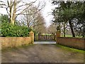 |
Gateway to Newtown Park by Oliver Dixon On the road from South Baddesley to Portmore. The big house can just be seen at the end of the drive. |
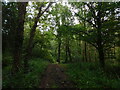 |
Shotts Copse, Lymington (set of 3 images) by Bryn Holmes |
 |
Newtown Park, airstrip by Mike Faherty Off Shotts Lane, on the Solent Way. According to an information board, the site of Lymington Airfield, home to the American 50th Fighter Group, flying sorties to France before D-Day; restored to farmland in 1946, and now an airstrip for... (more) |
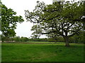 |
Grazing and trees, South Baddesley by JThomas |
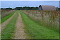 |
Track and hangar at former RAF Lymington by David Martin |
 |
Shotts Lane beside Shotts Copse by Stuart Logan |
 |
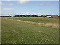
Farmland north of Pylewell Park by Pierre Terre |
 |
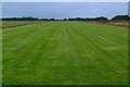
The Solent Way (61) by Shazz The route crosses a runway near Snooks Farm. The notice erected by Newtown Park Estate advises "Aircraft Landing Strip Crosses Track Ahead. Please Look Left and Right Before Proceeding". |
 |
Grass airstrip on site of former RAF Lymington by David Martin |
 |
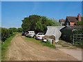
Remains of Lymington Airfield, Snooks Farm by Peter Facey Built in 1943, the airfield was used by American Thunderbolt aircraft in support of the D-day landings. The airfield was returned to farming in 1946. A single blister hangar remains, to the left of which is a white modern building. An Alvis... (more) |
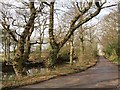 |
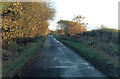
New Forest lane by Oliver Dixon The road from South Baddesley to Portmore. A small pond lies opposite the entrance to Newtown Park. |
Display Format:
|
Background Colour: White / /