Granada-Fort Union Military Road – Legends of America (original) (raw)
Granada-Fort Union Road Map.
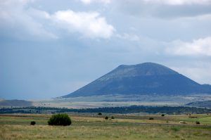
Capulin Mountain, New Mexico, by Kathy Alexander.
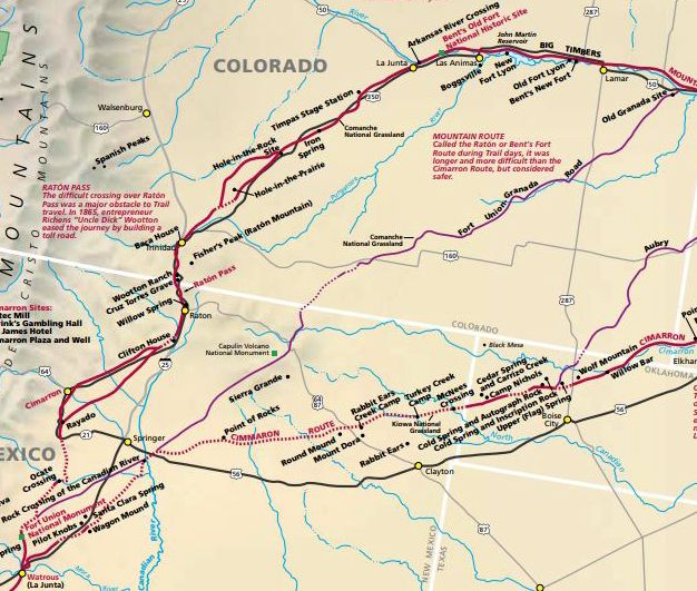
The Granada-Fort Union Military Road ran for 200 miles south from the Arkansas River north of Old Granada, Colorado, through the Comanche National Grasslands to Branson, Colorado, and Emery Gap, New Mexico, before making its way east of Capulin Mountain and continuing to Fort Union.
Shortly after Fort Union, New Mexico was established in 1851, Lieutenant Colonel Edwin Sumner, the fort’s commander, ordered Lieutenant John Pope to scout a better route along the Santa Fe Trail for military freight.
For years, the route Pope discovered was a little-used trail, but between 1867 and 1876, this road became part of the Goodnight Trail, used to send cattle north from Texas.
In the early 1870s, a Missouri man named Bazil Metcalf blazed a road down the short canyon that leads south out of Emory Gap into the Dry Cimarron Valley in New Mexico. Metcalf completed the road in 1873 and opened a store and saloon near the tollgate, comprised of a chain stretched across the road between two boulders. The fee for passage through the canyon was 75¢ for a four-horse wagon, 40¢ for a two-horse team, and 35¢ for buggies. A fee was also charged for the numerous cattle driven through to feed the mining camps and military posts to the north.

Granada-Fort Union Road Map.
Bazil operated the tollgate with his brother John, who came from Missouri to help run the tollgate and Bazil’s ranch. The brothers weathered Comanche and Kiowa raids that struck the Dry Cimarron in the summer of 1874, leaving 17 settlers dead. Bazil would have another Indian encounter in 1876 but would escape without harm. The tollgate operated from 1873 until 1885, serving as an important commercial route.
The route became heavily used when the Atchison, Topeka, and Santa Fe Railroad reached Old Granada, Colorado, in July 1873. Tons of freight traveled south along the trail to Fort Union and beyond. This trail became the major supply route for military and civilian goods heading southwest to New Mexico for several years.
After the first steam engine reached Trinidad, Colorado, in 1878 and Santa Fe, New Mexico, the Granada – Fort Union Military Road fell into disuse two years later.
The road was also called the Two Buttes Fork of the Mountain Branch and the Granada Branch of the Santa Fe Trail. Today, a six-mile route segment is preserved on the Comanche National Grassland.
©Kathy Alexander/Legends of America, updated July 2024.
Also See:
Mountain Branch of the Santa Fe Trail

Comanche National Grasslands, Colorado.
Santa Fe Trail – Highway to the Southwest
Tales & Trails of the Frontier
Sources: