Natchez Trace – Traveled For Thousands of Years – Page 2 – Legends of America (original) (raw)
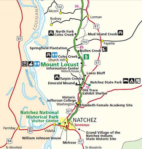
Natchez Trace Parkway from the southern terminus to milepost 30 at Mississippi Highway 552.
Natchez Trace Map, miles 0-30
| Milepost | Points of Interest |
|---|---|
| 0 | The Southern Terminus of the 444-mile-long Natchez Trace Parkway begins in Natchez, Mississippi. It is accessed off Liberty Road. One of the many beautiful bridges along the Trace takes you over Liberty Road just outside historic downtown Natchez. |
| 0 | Side Trip – Grand Village of the Natchez, Natchez, Mississippi – The Natchez Indians lived in southwest Mississippi from about 700-1730 AD. Historical and archaeological evidence shows that Grand Village was their main ceremonial center starting around 1682. The early French inhabitants of the area described the ceremonial mounds built by the Natchez Indians on the banks of St. Catherine Creek as the “the Grand Village of the Natchez Indians.” In 1729, after several disagreements and acts of violence, the Indians provoked war with the French and were subsequently destroyed as a people. The 128-acre Grand Village site features a museum, a reconstructed Natchez Indian house, and three ceremonial mounds. From the Natchez Trace Parkway’s southern terminus, turn onto U.S. Highway 61 South (Seargent S. Prentiss Drive); turn left onto Jefferson Davis Boulevard. The Grand Village of the Natchez Indians will be on your right. |
| 5.1 | Washington, Mississippi – The second state capital of Mississippi, Washington provides views of several historic buildings, including: Elizabeth Female Academy Ruins – Founded in 1818, this was Mississippi’s first female educational institution. It was named after Mrs. Elizabeth Roach Greenfield, who donated the school’s land. It closed in 1845. Historic Jefferson College – Opened in 1811, this all-male, college-preparatory academy as a military-style boarding school. It closed its doors in 1964 and is a state historic park and museum today. |
| 8.7 | Old Trace Exhibit Shelter – Near here is a portion of the Old Natchez Trace, the wilderness road that grew from wild animals and Indian Trails. Traders, soldiers Kaintucks, postriders, circuit-riding preachers, outlaws, settlers, and adventurers trampled this path. |
| 10.3 | Emerald Mound -This is the second-largest Indian Temple Mound in the United States. It was built and used between 1300 and 1600 A.D. by the forerunners of the Natchez Indians. These Indians used a natural hill as a base, which they reshaped by trimming the top and filling the sides to form a great primary platform, 770 feet long, 435 feet wide, and 35 feet high. At the west end still stands a 30-foot secondary mound once topped by a ceremonial structure. Exit the Natchez Trace Parkway at Mississippi Highway 553 and go west one mile. |
| 10.3 | Side Trip – Church Hill Loop Route – At the south end of the loop, exit the Natchez Trace Parkway at milepost 10.3 (the Emerald Mound exit). After a tenth of a mile, Highway 553 bears to the right (Emerald Mound’s road goes straight). Christ Church is 6.5 miles to the north. Continue north on Highway 553 past the Springfield Plantation entrance, and the highway heads east back to the Natchez Trace Parkway at milepost 20. The rural community of Church Hill is located at the intersection of Mississippi Highway 553 and Church Hill Road. The area is named after Christ Church, which sits atop a terraced hill. Built in about 1790, the building’s design was copied from England’s old country church buildings. Across the intersection is a wooden country store built around 1837. The store bears the name Wagners Grocery on the upper header of the store. The store, which also housed the post office, was closed in the late 1990s. Antebellum plantations line both sides of Highway 553. The Church Hill Loop is 22 miles long – 12 miles along Mississippi Highway 553 and 10 miles along the Natchez Trace Parkway from milepost 10.3 to milepost 20. Sites along the Natchez Trace Parkway section of the loop include Bullen Creek, Coles Creek, Mount Locust, Loess Bluff, Turpin Creek, and Emerald Mound. |
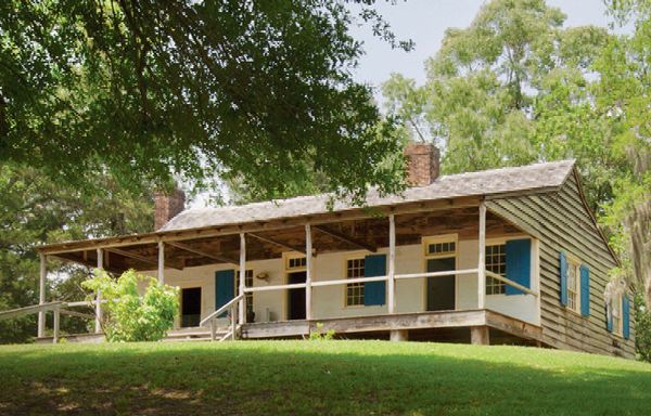
| 15.5 | Mount Locust – The only remaining inn, or “stand” on the Parkway, Mount Locust allows you to see what the “Kaintucks” may have experienced at the roadside stands. It is open year-round, except for December 25, and rangers are available from 9:00 am to 4:30 pm to share information on the historic structure. |
Mt Locust, Mississippi, by Kathy Alexander.

