Natchez Trace – Traveled For Thousands of Years – Page 9 – Legends of America (original) (raw)
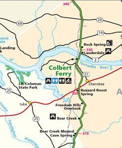
Natchez Trace Parkway from milepost 308 to 338
| Milepost | Points of Interest: |
|---|---|
| 308.9 |  Alabama-Mississippi State Line – Except for the immediate area around Mobile and the Yazoo lands, what is now central Alabama was made part of the Mississippi Territory upon its creation in 1798. The Yazoo lands were added to the territory in 1804 following the Yazoo land scandal. Spain had kept a governmental presence in Mobile after 1812. When Andrew Jackson’s forces occupied Mobile in 1814, he demonstrated the United States de facto authority over the region, which effectively ended Spanish influence, although not its claim, while gaining an unencumbered passage to the Gulf of Mexico from the hinterlands of the territory. Before Mississippi’s admission as a state on December 10, 1817, the more sparsely settled eastern half of the territory was separated, and Congress created Alabama Territory on March 3, 1817. St. Stephens, now abandoned, served as the territorial capital from 1817 to 1819. Alabama-Mississippi State Line – Except for the immediate area around Mobile and the Yazoo lands, what is now central Alabama was made part of the Mississippi Territory upon its creation in 1798. The Yazoo lands were added to the territory in 1804 following the Yazoo land scandal. Spain had kept a governmental presence in Mobile after 1812. When Andrew Jackson’s forces occupied Mobile in 1814, he demonstrated the United States de facto authority over the region, which effectively ended Spanish influence, although not its claim, while gaining an unencumbered passage to the Gulf of Mexico from the hinterlands of the territory. Before Mississippi’s admission as a state on December 10, 1817, the more sparsely settled eastern half of the territory was separated, and Congress created Alabama Territory on March 3, 1817. St. Stephens, now abandoned, served as the territorial capital from 1817 to 1819. |
| 313 | Bear Creek – A shady picnic area with several picnic tables and grills next to Bear Creek near the Alabama-Mississippi state line. |
| 317 | Freedom Hills Overlook – On the way up the trail, there are two benches where you can stop and rest before continuing up the hill. Another bench is placed conveniently at the top of the trail. This is the highest point on the Trace in Alabama. |
| 320 | Side Trip – Tuscumbia, Alabama – The county seat of Colbert County, Alabama, Tuscumbia, got its start in about 1816 when the Michael Dixon family arrived. They traded with Chief Tuscomby for the Tuscumbia Valley and built their home at the head of the big spring. A village known as the Big Spring Community quickly developed from these humble dwellings. In 1822 it was renamed Tuscumbia after the Chief Rainmaker of the Chickasaw. A line to the town on the Tuscumbia, Courtland, and Decatur Railroad was completed in 1832, and by 1850, Tuscumbia was a central railroad hub for train traffic throughout the South. During the Civil War, the railroad hub made Tuscumbia a target of the Union Army, which destroyed the Tuscumbia depot and other parts of the town. Today, it is called home to about 8,400.Helen Keller’s Birthplace – Located in Tuscumbia, Alabama, about 19 miles east of the parkway, Ivy Green, Helen Keller’s birthplace, has been a permanent shrine to the “miracle” that occurred to the blind and deaf seven-year-old girl’s life. In 1954, the site was opened as a museum and placed on the National Register of Historic Places. Helen was born healthy on June 27, 1880. However, when she was 19 months old, she was stricken with a severe illness that left her blind and deaf. Her parents sought Dr. Alexander Graham Bell’s advice, who introduced them to Anne Sullivan on March 3, 1887. After her miraculous breakthrough at the well pump, where she learned the word “water,” she soon learned the alphabet and over 600 words in six months. By age 10, she had mastered Braille and learned to use a typewriter. By 16, Helen could speak well enough to attend school. In 1904 she graduated “cum laude” from Radcliffe College. Her teacher, Anne Sullivan, stayed by her side as Helen dedicated her life to improving the conditions of blind and deaf-blind people worldwide. Located at 300 North Commons Street, West Tuscumbia, AL 35674. Exit the Trace at milepost 320 onto U.S. Highway 72 and travel 19 miles east. Spring Park – Located in downtown Tuscumbia, just south of the central business district, Spring Park consists of a large spring forming a lake. Located inside Spring Park is Cold Water Falls, the world’s largest man-made natural stone waterfall to be known in existence. The waterfall was constructed in 120 days, and the largest stone weighs 77,000 pounds. Approximately 4,320,000 gallons of water pass over the falls each day. The lake features a memorial water fountain dedicated to the memory of Princess Im-Mi-Ah-Key, the wife of Chief Tuscumbia. There are 51 jets that make up the fountain. The center jet shoots water over 100 feet into the air and the other 50-shoot water 40-50 feet into the air. All jets are choreographed to lights and music. Alabama Music Hall of Fame – From musicians to songwriters, management, and publishing, The Alabama Music Hall of Fame provides several ways of honoring its “achievers,” including informative exhibitions, a bronze star on their Walk of Fame, and the achievers’ inclusion in the Hall of Fame roster. The 12,500 sq ft facility is located at 617 Highway 72 West in Tuscumbia. |
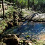
| 320.3 |  Buzzard Roost Spring – Originally called Buzzard Sleep, the name was changed to Buzzard Roost in 1801 by Levi Colbert, a renowned Chickasaw chief. The spring was a water source for the Colbert house, serving as an inn for travelers on the Old Natchez Trace. Travelers who stopped here remarked that its a good place, for they were well received, well-fed, and kindly treated. Levi was a brother to George Colbert. They both ran the Colbert Ferry, and their stands were about 2 hours apart by horseback. Buzzard Roost Spring – Originally called Buzzard Sleep, the name was changed to Buzzard Roost in 1801 by Levi Colbert, a renowned Chickasaw chief. The spring was a water source for the Colbert house, serving as an inn for travelers on the Old Natchez Trace. Travelers who stopped here remarked that its a good place, for they were well received, well-fed, and kindly treated. Levi was a brother to George Colbert. They both ran the Colbert Ferry, and their stands were about 2 hours apart by horseback. |
| 327.3 | Colbert’s Stand and Ferry – George Colbert, a half-Scot half-Chickasaw chief, operated a ferry across the Tennessee River from 1800 to 1819. His stand, or inn, offered travelers a warm meal and shelter during their Old Trace journey. He owned the ferry with his brother, Levi Colbert, who ran a stand at Buzzard Roost Spring. Looking after their best interests, they allegedly charged Andrew Jackson $75,000 to ferry his Tennessee Army across the river. The site of his stand is a short 50 yards up the path from the parking area. An additional 20-minute stroll will take you along the Old Trace to the bluff overlook and back. After a venison supper, one guest at Colbert’s Stand spent the night in an outbuilding (Wilderness Haven) with “not less than 50 Indians, many of them drunk.” Here, and at about 20 other stands along the Trace, Kaintuck riverboat men, money-laden businessmen, Indians, and outlaws shared a spot of fellowship on a long, hazardous road. Today, a beautiful bridge crosses the Tennessee River. Includes picnic tables, restrooms, and a boat launch. |
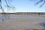
| 328.4 |  Tennessee River – The .8 mile-long John Coffee Memorial Bridge carries the Natchez Trace Parkway across the Tennessee River. A few miles downstream, Pickwick Landing Dam widens the river at this crossing. The bridge is named after General John Coffee, who was under Andrew Jackson’s command at the Battle of New Orleans in 1815. Tennessee River – The .8 mile-long John Coffee Memorial Bridge carries the Natchez Trace Parkway across the Tennessee River. A few miles downstream, Pickwick Landing Dam widens the river at this crossing. The bridge is named after General John Coffee, who was under Andrew Jackson’s command at the Battle of New Orleans in 1815. |
| 330.2 | Rock Spring Nature Trail – A short half-mile loop trail that takes you past Colbert Creek offers an opportunity to explore a small natural spring as it bubbles forth from the ground. When the jewelweed is in bloom in late summer, visitors may be rewarded with views of the ruby-throated hummingbirds as they migrate south. The trails and stepping stones in the area lead you across Colbert Creek past Rock Spring and through the woodlands. Since 1977, numerous beaver dams have been built and then abandoned by the beaver or destroyed by high water. |
| 338 | Wichahpi Commemorative Stone Wall – Since 1988, a man named Tom Hendrix has painstakingly created the most significant memorial to a Native American woman in the United States. The wall is built in memory of his great-great-grandmother, Te-lah-nay, a Yuchi Indian who was part of the American Indian Removal to Oklahoma. Te-lah-nay and her family lived near the Tennessee River, which they called the Singing River because they believed a woman who lived there sang to them. When Te-lah-nay arrived in Oklahoma, she was homesick because the rivers did not sing to her. After spending just one winter in Indian Territory, Te-lah-nay returned to Mississippi alone, facing hardship and peril. Learning of her courage from his grandmother, Tom wanted to do something to honor her memory. During a conversation with an elder of the Yuchi tribe, he was told, “All things shall pass. Only the stones will remain.” It was then that he knew what he needed to do. Since then, Tom has been building the wall, lifting nearly 2,700 pounds daily, constructing the largest un-mortared stone wall in the country. His tribute includes a prayer circle and a music circle and is home to fertility objects and miracle stones. Because he believes this healing wall and spiritual space belong to everyone, Tom welcomes visitors to experience Te-lah-nay’s journey and honor our ancestors. The Wichahpi Commemorative Stone Wall is located just east of the parkway near milepost 338. |
Continue next page for mileposts 339 to 442
