18 Best Hikes in the Alps: Day Hikes, Treks, and Walks (original) (raw)
The hiking season in the Alps starts in June and ends in September, or October if you’re lucky. Each year, between November and May, Kati and I are counting down the days until summer, so that we can hike once again in the Alps.
We spend our winters researching Alps hiking trails and Alpine trekking routes and we spend our summers savoring each moment in these glorious mountains.
Needless to say, there’s no place that we love more than this majestic mountain chain, which arches across eight countries.
Though not as wild as other corners of the world, the Alps are nonetheless a dream destination for hiking (eating, vacationing, wine tasting, pampering, etc…) in Europe.
I know of no other place where you can hike a thrilling ridge trail in the day and then return to your hotel to luxuriate in the wellness facilities, before sitting down to a 5-course gourmet dinner.
Maybe we’re gluttons and hedonists, but I don’t want to live another way. Do you?
We’ve written hundreds of guides about hiking in the Alps. This is simply a taster, an enticing sampling of what awaits you when you come here.
- 1. Partnach Gorge, Bavarian Alps
- 2. Grand Balcon Nord, Chamonix, French Alps
- 3. Hofpürgl Hut to Sulzenalm Circuit Hike, Austrian Alps
- 4. Lake Formarinsee to Lake Spullersee, Austrian Alps
- 5. Triglav Lakes Valley, Slovenian Alps
- 6. Hochplatte, Bavarian Alps
- 7. Marwees Ridge Trail, Swiss Alps
- 8. Piz Duleda, Italian Alps
- 9. Tofana di Rozes Circuit Trail, Italian Alps
- 10. Sentiero Bonacossa Trail, Italian Alps
- 11. Lake Drachensee, Austrian Alps
- 12. Veliko Špičje Ridge Hike, Slovenian Alps
- 13. Triglav National Park Trek, Slovenian Alps
- 14. Schladminger Tauern High Trail, Austrian Alps
- 15. Rätikon Alps Circuit Trail, Austrian Alps and Swiss Alps
- 16. Liechtenstein Panorama Trail (Route 66), Liechtenstein Alps
- 17. Alpstein High Trail, Swiss Alps
- 18. Alta Via 1, Dolomites, Italian Alps
- Alps Hiking Gear

- Where: The European Alps span across eight countries: Austria, Switzerland, France, Italy, Slovenia, Germany, Liechtenstein, and Monaco
- Tips for Hiking in the Alps: Hiking in the Alps: What You Need to Know
- Alps in Summer: Read Visiting the Alps in Summer
- Best Destinations in the Alps for Hiking: Appenzell in Switzerland; Lake Achensee, Lech am Arlberg, Mayrhofen, Schladming, and Filzmoos in Austria; Garmisch-Partenkirchen in Germany; Lake Bohinj, Lake Bled, and Kranjska Gora in Slovenia; Cortina d’Ampezzo and Ortisei in Italy
- Hiking Season: Mid-late June to mid-late October, depending on snow/ice conditions.
- Hut to Hut Hiking Season: Late June/early July to late September
Best Walks in the Alps
1. Partnach Gorge, Bavarian Alps

Partnach Gorge is a deep river gorge in the Reintal Valley in Garmisch-Partenkirchen in Bavaria, Germany.
Millions of years ago, meltwater and debris hollowed out the rock, creating this dazzling 700-meter-long narrow gorge.
This is a suitable excursion for families with children. A safe path leads through the galleries, caves, and ledges of Partnach Gorge.
The Partnach Gorge hiking trail starts at the Garmisch Olympia Stadium where there’s a bus stop and pay-and-display car park. From the car park, it’s a 20-minute walk to the gorge entrance.
It takes only 20 minutes to walk the length of the gorge. We recommend extending the hike the Berggasthof Eckbauer mountain restaurant. You can eat at Kaiserschmarrn-Alm, located near Hotel Graseck, or later at Berggasthof Eckbauer. Bring cash.
From Berggasthof Eckbauer, the circuit trail continues to the tiny church village of Wamberg and then all the way down to the Garmisch Olympia Stadium.
Trail Stats
Trailhead | Garmisch Olympia Stadium
Distance | 12.1 km circuit
Time Needed | 4:10 hours
Elevation Gain/Loss | 549 meters
Difficulty | Easy
Learn More: Partnachklamm Gorge Hike
2. Grand Balcon Nord, Chamonix, French Alps

The highest mountain in Europe, west of the Caucasus, is Mont Blanc (4,809 meters / 15,777 feet). Straddling the French-Italian border, the Mont Blanc mountain range is famous for its cascading glaciers, ice-crusted domes, and sharp needle-like peaks.
People from all over the world flock to Chamonix, France. to see Mont Blanc. One of the most popular hiking trails in Europe circumnavigates the Mont Blanc Range. You’ve probably heard of it: the famous Tour du Mont Blanc.
You don’t have to be a mountaineer or a long distance hiker to take in the beauty of these magnificent mountains. There are some spellbinding balcony trails above Chamonix Valley, suitable for everyone.
The Grand Balcon Nord trail connects Montenvers with Plan de l’Aiguille. It’s an easy panoramic trail with wondrous views of Mer de Glace (Sea of Ice) glacier, the Aiguilles de Chamonix (Chamonix Needles) group of the Mont Blanc massif, and the Aiguilles Rouges massif.
Trail Stats
Trailhead | Montenvers-Mer de Glace train station in Chamonix
Distance | 12.6 km out-and-back
Time Needed | 4:40 hours
Elevation Gain/Loss | 532 meters
Difficulty | Easy
Learn More: Grand Balcon Nord Hike
Best Day Hikes in the Alps
3. Hofpürgl Hut to Sulzenalm Circuit Hike, Austrian Alps

One of our favorite hikes in the Alps runs along the base of the Bischofsmütze and Gosaustein in the Dachstein Mountains in Salzburg, Austria. This hike is all about stunning limestone mountains, varied terrain, and huts.
This day hike starts at the Hofalm mountain pasture in Filzmoos, accessible by bus, or car via the Hofalm toll road.
From Hofalm, the trail ascends to Hofpürglhütte (1705 m), a mountain hut located beneath the Bischofsmütze twin peaks.
The route follows the Linzerweg hiking trail across the boulder-filled Kesselwand and continues east to Rinderfeld, a gorgeous meadow flanked by soaring limestone walls.
After crossing this mountain pasture, the trail drops below the tree line and then zigzags up to the Sulzenschneid Spur.
After cresting the spur, the path leads to the highest point, Eiskarlschneid, and then descends to the Sulzenhals saddle.
Merging with the Rötelstein hiking trail, the path wanders through dwarf pine and later larches to reach the rolling pasture area of Sulzenalm.
Sulzenalm is home to two enticing huts, Wallehenhütte and Krahlehenhütte, which serve delicious meals throughout the day.
From Sulzenalm, it’s a 45-minute descent to Hofalm.
Trail Stats
Trailhead | Filzmoos, Salzburg, Austria
Distance | 12.9 km circuit
Time Needed | 5:15 hours
Elevation Gain/Loss | 912 meters
Difficulty | Moderate – Moderately Difficult
Learn More: Hofpürgl Hut to Sulzenalm Circuit Hike
4. Lake Formarinsee to Lake Spullersee, Austrian Alps

The spectacular hike from Lake Formarinsee to Lake Spullersee highlights some of the most enchanting landscapes of the Lechquellen Mountains near Lech am Arlberg in Vorarlberg, Austria.
Starting at the Freiburger hut at Lake Formarinsee, trail 601 ascends across wildflower-carpeted slopes and alpine pastures to Steinernes Meer (“Stone Sea”), an impressive karst landscape.
After navigating the rugged Stone Sea, the trail ascends to the Gehrengrat mountain ridge. Atop the ridge, views extend to the Rätikon Alps and the Silvretta Alps.
The way descends along the ridge to the dreamy Dalaaser Schütz high alpine valley. The final stretch leads down the valley to the Spullersee reservoir.
Trail Stats
Starting Point | Lake Formarinsee
Ending Point | Lake Spullersee
Distance | 11.4 km point-to-point
Time Needed | 4:30 – 5 hours
Elevation Gain | 637 meters
Elevation Loss | 673 meters
Difficulty: Moderately Difficult
Learn More: Formarinsee to Spullersee Trail Guide
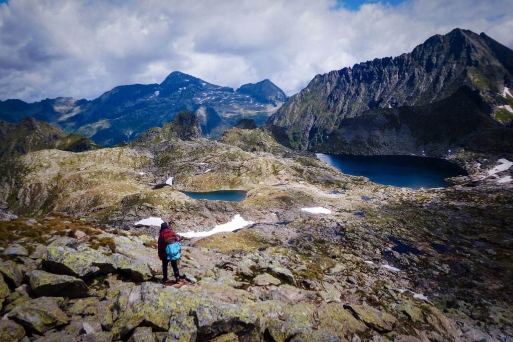
5. Triglav Lakes Valley, Slovenian Alps

Seven Lakes Valley, also known as Triglav Lakes Valley, is a high mountain valley in the Julian Alps, defined by a string of mountain lakes. This arresting destination embedded in Triglav National Park is only accessible by foot.
The hike to the Seven Lakes Valley begins at Planina Blato near Lake Bohinj.
Along the way, the trail crosses fairytale-like alpine pastures including Planina pri Jezeru, Planina Viševnik, and Planina Ovčarija.
From the Štapce saddle (1851 m), the path drops down steeply to Dvojno Jezero (Double Lake).
You can eat lunch at Koča pri Triglavskih jezerih (Triglav Lakes Hut), set near the shore of Double Lake, or continue hiking up Seven Lakes Valley.
If you press on for another 45 minutes, you’ll arrive at Veliko jezero (aka Jezero Ledvicah, or Kidney Lake), the largest lake in Triglav Lakes Valley. On a sunny day, this kidney-shaped lake dazzles resplendently with its deep teal and royal blue tones.
If you want to extend this hike, you can either overnight in the Triglav Lakes Hut, or hike all the way to the mountain hut Zasavska koča na Prehodavcih and spend the night there. Experienced hikers can tackle the Veliko Špičje summit and ridge and descend the Seven Lakes Valley the next day.
Hut to hut trekkers can hike to Triglav Lakes Valley along this 4-day Triglav National Park Trek.
Trail Stats
Trailhead |Planina Blato (1147 m), above Stara Fužina
Destination | Koča pri Triglavskih jezerih (1684 m)
Distance | 15.2 km circuit
Time Needed | 6 hours
Elevation Gain/Loss | 1051 meters
Difficulty | Moderate
Learn More: Seven Lakes Valley Hike
6. Hochplatte, Bavarian Alps

Hochplatte (2082 meters) is a mountain in the Ammergau Alps of Bavaria. The Hochplatte peak hike starts at Ammerwaldalm in Austria, which is a 36-minute drive from Garmisch-Partenkirchen.
This is a strenuous tour with a lengthy and somewhat airy ridge trail. Though all exposed sections are secured, this is only suitable for surefooted hikers with no fear of heights.
After conquering nearly 1000 meters in 3 hours, the hike continues from the Hochplatte summit along a narrow ridge to the Fensterl natural window. It’s a riveting trail with sweeping views and some fun scrambling sections.
From the Fensterl, the hike continues to the Roggentalsattel and down to Roggental valley, eventually rejoining the accent route.
This is a great hike to do on weekends during high season, because it’s still a secret.
Trail Stats
Trailhead | Ammerwaldalm, Austria
Distance | 10.6 km lollipop-circuit
Time Needed | 5:30 hours
Elevation Gain/Loss | 969 meters
Difficulty | Difficult
Learn More: Hochplatte Trail Guide
7. Marwees Ridge Trail, Swiss Alps

Marwees is a mountain in the heart of the Alpstein massif in the Appenzell Alps of Switzerland. Hikers flock to Appenzell to hike the popular Hoher Kasten – Saxer Lücke Trail, visit the cliffside Berggasthaus Aescher, and photograph the bewitching Schäfler Ridge.
Luckily, the Marwees ridge, one of the most stunning trails in the compact Alpstein range, is often overlooked.
Marwees is the mountain that rises up between Lake Seealpsee and the valley of Widderalp.
The best place to start the hike is in Wasserauen, accessible by train from Appenzell Village, or by car. From the paragliding landing area, adjacent to the car park, ascend to the Klein-Hütten mountain pasture.
At the Klein-Hütten trail junction, the Marwees hiking trail branches off to the left and ascends steadily to the Bogartenlücke mountain saddle.
From the Bogarten saddle, the way continues very steeply up a channel to the slopes of Marwees. A traverse brings you to the Marwees ridge. After a rigorous ascent to the Marwees Eastern Summit, the trail gracefully follows the slender spine of Marwees with views of Widderalpstöck (2058 m), Hundstein (2157 m), Altmann (2435 m), Ebenalp (1640 m), Schäfler (1924 m), and many more peaks.
The Marwees ridge path eventually skirts the highest summit and drops down to the Widderalpsattel saddle, Bötzelsattel saddle, and then Meglisalp (mountain inn, mountain pasture, chapel).
After a well-deserved break at Berggasthaus Marwees, the circuit trail descends to Lake Seealpse and then all the way down to Wasserauen.
Trail Stats
Trailhead | Wasserauen Train Station, or Wasserauen Car Park
Distance | 14.5 km circuit
Time Needed | 6:45 hours
Elevation Gain/Loss | 1225 meters
Difficulty | Difficult. Only hike this trail in dry conditions and in stable weather.
Learn More: Marwees Ridge Hiking Trail
8. Piz Duleda, Italian Alps

The trail leads up the lonesome Val dla Roa valley to Furcela Dla Roa/Roa Scharte saddle and climbs up the Sentiero Attrezzato Piz Duledes (protected trail / Grade A) to Furcela Nives saddle.
From Furcela Nives, it’s a straightforward ascent to Piz Duleda.
The trail continues, along crumbling rock towers, to Furcela Forces de Sieles (merging with the Col dala Pieres descending path) and drops down the scree-filled Forces de Sieles gully.
With views of the sawtoothed Odle (Geisler in German) peaks, the path eases and returns to Rifugio Firenze.
Trail Stats
Trailhead | Col Raiser Gondola Mountain Station
Distance | 12.4 km lollipop-circuit
Time Needed | 5 hours
Elevation Gain/Loss | 980 meters
Difficulty | Challenging
Learn More: Piz Duleda Trail Guide
9. Tofana di Rozes Circuit Trail, Italian Alps

Tofana di Rozes is one of the recognizable mountains in the Ampezzo Dolomites in Belluno, Italy.
A riveting hiking trail wraps around Tofana di Rozes, starting at Rifugio Dibona, near Cortina d’Ampezzo.
The trail initially crosses the southern slopes of Tofana di Rozes and then ascends gently to the Forcella Col dei Bos saddle. From the trail, you’ll see Marmolada, the Croda da Lago Chain, Lastoi de Formin, Ra Gusela, Cinque Torri, and more.
The path continues towards the remote Travenanzes valley and then steeply ascends the rugged Majarié glacial cirque to Rifugio Giussani.
From the Giussani mountain refuge, the Tofana di Rozes circuit trail descends back to Rifugio Dibona along First World War paths.
This is a quiet, varied, and absolutely spellbinding hike in Cortina d’Ampezzo.
Trail Stats
Trailhead | Rifugio Dibona, Dolomiti D’Ampezzo Natural Park, Belluno
Distance | 11.9 km circuit
Time Needed | 5:30 hours
Elevation Gain/Loss | 1266 meters
Difficulty | Moderately Difficult
Trail Guide: Tofana di Rozes Circuit Trail
10. Sentiero Bonacossa Trail, Italian Alps

Sentiero Alberto Bonacossa is a thrilling, semi-secured hiking trail that runs through the dramatic Cadini di Misurina mountain group in the Sexten Dolomites. This exciting path guides hikers along narrow, exposed ledges and steep rocky valleys.
Sentiero Bonacossa connects Rifugio Col de Varda with Rifugio Fonda Savio and Rifugio Auronzo. It links Lake Misurina with the south face of Tre Cime di Lavaredo.
It can be hiked in its entirety, or sectioned off in loops. We hiked the northern Rifugio Fonda Savio to Rifugio Auronzo route one year, and the southern Col de Varda to Rifugio Fonda Savio route another year.
One of the most popular destinations along the Sentiero Bonacossa trail is the famous Cadini di Misurina viewpoint.
This trail is a sentiero attrezzato, which is something between a standard hiking trail and a via ferrata (klettersteig / protected climbing route). We recommend wearing climbing helmets and climbing gloves for this route. Some people may want to bring a via ferrata kit.
Northern Trail Circuit Stats
Trailhead | Lake Antorno, or Rifugio Auronzo
Distance | 12.5 km circuit
Time Needed | 6 hours
Elevation Gain/Loss | 869 meters
Difficulty | Challenging
Learn More: Sentiero Bonacossa North Trail
11. Lake Drachensee, Austrian Alps

Drachensee is a mountain lake in the Mieming Chain in Tyrol.
A very satisfying trail loops around Tajakopf mountain, passing Lake Brendlsee, Lake Drachensee, and Lake Seebensee along the way.
Starting at the Ehrwald Almbahn gondola mountain station, this Alps hike meanders gently through forest before ascending the Ganghofersteig trail to the Brendlkar cirque and then eventually up to the Tajatörl saddle.
This long ascent is somewhat taxing, but there’s no (minimal) technical difficulty. Hikers should nonetheless be sure-footed and confident in scree.
With the hard part behind you, the trail descends to Lake Drachensee and Coburger Mountain Hut.
From the happily-situated Coburger mountain hut, the path steeply descends to Lake Seebensee and then returns to the Ehrwald Alpine Pasture.
Trail Stats
Trailhead | Ehrwald Almbahn gondola mountain station
Distance | 14.9 km lollipop-circuit
Time Needed | 5:30 hours
Elevation Gain/Loss | 909 meters
Difficulty | Moderate – Moderately Difficuly
Learn More: Lake Drachensee Hiking Trail
Alpine Treks: Hut to Hut Hiking Trails in the Alps
12. Veliko Špičje Ridge Hike, Slovenian Alps

Veliko Špičje (2398 m) is the highest summit on the Špičje ridge, which rises between the deep Trenta Valley and the high Seven Lakes Valley (aka Triglav Lakes Valley) in the Julian Alps of Slovenia.
This adventurous 2-day tour combines the Špičje ridge with the Seven Lakes Valley, starting and ending at Planina Blato.
Day 1 ends at Zasavska koča na Prehodavcih, a mountain hut on the Prehodavci Pass. To learn more about staying in huts, read Slovenian Mountain Huts and Hut to Hut Hiking in Slovenia.
Trail Stats
Trailhead | Planina Blato
Distance | 27.6 km circuit
Days Needed | 2 days
Difficulty | Challenging
Learn More: Veliko Špičje Trail Guide
13. Triglav National Park Trek, Slovenian Alps

Triglav National Park is Slovenia’s one and only National Park. The park territory corresponds to the Eastern Julian Alps and can be accessed from Kranjska Gora, Trenta, Kobarid, Bovec, Pokljuka, Ukanc, Stara Fužina, and other towns. It’s free to enter the park, and you don’t need to acquire any permits.
There’s so much to see and experience in Triglav National Park and there’s no better way to do it than trekking across the park in a few days.
Our 4-Day Triglav National Park Trek starts in Vršič Pass, near Kranjska Gora, and ends in Stara Fužina at Lake Bohinj. Along the way, you’ll overnight in 3 mountain huts, summit Bovški Gamsovec and Kanjavec, hike to the alpine plateau of Kriških podih and the Seven Lakes Valley, and see Mount Triglav from multiple angles.
Trail Stats
Sarting Point | Vršič Pass
Ending Point | Lake Bohinj
Distance | 45 km point-to-point
Days Needed | 4 days
Difficulty | Difficult
How to Book | If you want to hike this trek independently, but you also want to summit Mount Triglav with a mountain guide (optional), we recommend booking this self-guided Crossing the Julian Alps hiking tour with Slotrips.
Learn More: 4-Day Triglav National Park Trek
14. Schladminger Tauern High Trail, Austrian Alps
The Schladminger Tauern mountains are a subrange of the Austrian Central Alps and are located in the states of Salzburg and Styria (Steiermark).
Virtually unknown to anyone outside of the German-speaking world, this secret European hiking destination shouldn’t be overlooked.
There are two compelling reasons why you should hike the 5-day Schladminger Tauern High Trail. First, alpine lakes. Along the Schladminger Höhenweg, you’ll pass numerous pristine alpine lakes including Giglachseen and Landwirseen.
The most impressive water-abundant destination along the route is Klafferkessel, a cirque containing more than 30 lakes.
Second, cuisine. The food in the mountain huts is DELICIOUS, especially at Keinprechtshütte and Preintalerhütte.
Learn more: hut to hut hiking in Austria, mountain huts in Austria, and best treks in Austria.
Trail Stats
Starting Point/Ending Point | Schladming
Duration | 5 Days
Distance | 45 km circuit
Difficulty | Difficult
Learn More: Schladming Tauern Trek
15. Rätikon Alps Circuit Trail, Austrian Alps and Swiss Alps

The Rätikon Alps are part of the Central Eastern Alps and form part of the natural border between Vorarlberg, Austria, and Graubünden, Switzerland, and Liechtenstein.
This range romances hikers with its shimmering limestone peaks, verdant slopes, active alpine pastures, and mountain lakes. It’s like a waking dreamland, almost too beautiful to be real.
Our Rätikon Alp 5-day trekking itinerary follows the Rätikon Höhenweg Nord (North Rätikon High Trail) in Vorarlberg, Austria and the Prättigauer Höhenweg (Prättigau High Trail) in Graubünden, Switzerland. You’ll stay overnight in two nights Austrian mountain huts and two Swiss mountain huts.
Beginning at the majestic Lünersee (Lüner Lake), this trek starts out very gently. If you’re completely new to multi-day hiking, this is a great place to start.
There are no brutal ascents or descents. The only challenging section is the ascent from Schesaplanahütte to Schesaplana, the highest peak in the Rätikon.
Trail Stats
Starting Point/Ending Point | Lünersee
Duration | 3 – 5 Days
Distance | 51 km circuit
Difficulty | Easy – Moderate
Learn more | Austrian Alps Hiking Destinations
Learn More: Raetikon Alps Trek
16. Liechtenstein Panorama Trail (Route 66), Liechtenstein Alps

The Liechtenstein Panorama Trail (Liechtenstein Panoramaweg in German) is a 42+ km hiking trail in the Rätikon Alps in the Principality of Liechtenstein.
Wedged between Austria and Switzerland, Liechtenstein is one of the 8 alpine states of Europe and the world’s sixth-smallest nation.
This moderately-difficult hiking trail traces the Rätikon ridge that divides the Rhine Valley from Saminatal Valley and later Valünatal Valley. It’s an exciting, well-secured alpine trail with a great deal of variance: forest trails, meadow crossings, and ridge paths.
It takes 3-4 days to hike from Ruggell (or Planken) to Malbun. Along the way, you’ll summit a series of peaks and stay in some very hospitable mountain huts (and hotels).
Despite being relatively short, this is an extremely memorable hike in the Alps. If you’re looking for something challenging, but also very safe and secure, consider trekking Route 66 in Liechtenstein.
Trek Stats
Starting Point | Ruggell (or Planken)
Ending Point | Malbun
Duration | 3-4 Days
Distance | 42-47 km
Difficulty | Moderately Difficult
Learn More: Liechtenstein Panorama Trail Hiking Guide
17. Alpstein High Trail, Swiss Alps

The Alpstein High Trail is a 3-day hut-to-hut hike, which follows the high trails of the Alpstein Massif in the Appenzell Alps of Switzerland.
This thrilling path connects the Alpstein’s most alluring landscapes and destinations including Lake Seealpsee, Berggasthaus Aescher, Schäfler Ridge, the Altenalp Towers, Mount Säntis, Lisengrat Ridge, Rotsteinpass Hut, the Saxer Lücke saddle, and Hoher Kasten.
Stay in the charming village of Appenzell before/after trekking this route.
Trek Stats
Starting Point | Wasserauen
Ending Point | Hoher Kasten, Brülisau
Duration | 3 Days
Distance | 33.5 km
Difficulty | Moderately Difficult
Learn More: Apstein High Trail
18. Alta Via 1, Dolomites, Italian Alps

The Alta Via 1 (aka Dolomiten Höhenweg 1) is an approachable, long-distance hiking trail in the Italian Dolomites, starting at Lago di Braies (Pragser Wildsee) in South Tyrol and ending at the La Pissa bus stop near Belluno.
This 120-km-long Dolomites high route is hiked north to south and generally broken up into 10 stages. Many hikers will hike the north route (4 stages), or the south route (6 stages).
The AV1 is a fabulous introduction to the Dolomites and its many subranges. The views are sensational and the trail itself is very moderate.
It’s a very popular hiking trail, so it’s critical to book mountain huts 6 months in advance. Otherwise, book a self-guided tour, where the tour operator handles the booking and you hike independently. We recommend Alpenventures UNGUIDED (they booked our Tour du Mont Blanc hike). They offer a slow-paced 13-day AV1-13 Alta Via 1 Self Guided, moderately-paced 10-day AV1-10 Alta Via 1 Self Guided, fast-paced 7-day AV1-7 Alta Via 1 Self Guided, and a short 4-day AV1-4 Alta Via 1 Self Guided.
Trek Stats
Starting Point | Lago di Braies
Ending Point | Belluno (La Pissa bus stop)
Duration | 4 – 10 Days
Distance | 120 km point-to-point
Difficulty | Easy – Moderate
Learn more | Dolomites hut to hut hiking guide and Italian Alps hiking destinations
Learn More: Alta Via 1 Hiking Guide

GET YOUR FREE EBOOK
Signup for our newsletter to get our guide to “Secret Hiking Destinations in Europe.”
Alps Hiking Gear
The Essentials
- Day Pack: Osprey Tempest 30 Women’s Backpack / Osprey Talon 33 Men’s Backpack
- Hut to Hut Hiking Backpack: Women’s Osprey Kyte 36 / Men’s Osprey Kestrel 38
- Grade B/C high-cut hiking boots: Meindl Schuhe Island Lady (Kati’s Boots), Women’s Hanwag Tatra II GTX (Sabrina’s Boots), Men’s Hanwag Tatra II GTX (men’s equivalent)
- Wool Hiking Socks: Smartwool womens Performance Hike Full Cushion Crew / Smartwool Men Performance Hike Full Cushion Crew
- CAT 4 Sunglasses: Julbo Shield Mountain Sunglasses
- Hiking Poles:Black Diamond Trail Trekking Poles
- Reusable Water Bottle: Ion Leakproof 32 oz Water Bottle
Hiking Accessories
- Climbing Gloves: Black Diamond Half Finger Gloves
- Headlamp: Black Diamond Equipment Spot 350 Headlamp
- Microspikes: CAMP USA Inc Chainsen Pro
Special Equipment
- Women’s Climbing Helmet: black diamond women’s climbing helmet
- Men’s Climbing Helmet: black diamond men’s climbing helmet
- Unisex Climbing Gloves: Black Diamond Crag Half-Finger Gloves
Outdoor Photography Gear
- Camera Body: Sony Alpha a6400
- Mid-range Zoom Lens: Tamron 17-70mm 2.8 Di III-A VC RXD
- Wide angle Zoom Lens: Sony – E 10-18mm F4 OSS Wide-angle Zoom Lens
- Backpack Camera Clip: Peak Design Camera Clip

Moon & Honey Travel is an independent blog created by two passionate hikers. We are able to provide free content to you, because of ads and affiliate links. When you make a purchase using one of these links, we may receive a small commission at no extra cost to you. Happy travels and happy trails, Sabrina and Kati