Hiking to the Cadini di Misurina Viewpoint: 4 Routes + Map (original) (raw)
Cadini di Misurina is an awe-inspiring mountain group of the Sexten Dolomites in the Italian Dolomites, Northern Italy.
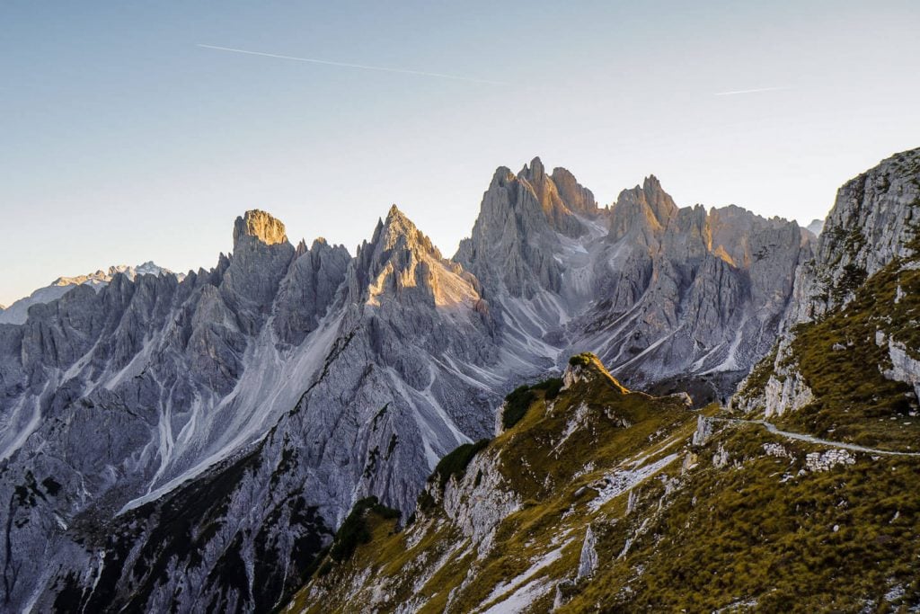
Defined by sharp, slender spires and pinnacles, the jagged Cadini di Misurina mountains look like the imagined backdrop of a high fantasy epic.
The name “Cadini” refers to the many high valleys and cirques – called “cadin” or “ciadin” – that dissect the massive towers of the Cadini Group. “Misurina” refers to Lago di Misurina, the beautiful lake that lies at the southwestern foot of the Cadini di Misurina Mountains.
Though the Cadini di Misurina Peaks are striking from multiple angles (e.g. Lake Misurina, Lake Antorno, Val de le Cianpedele), there’s one vantage point that upstages all others. Nicknamed the Cadini di Misurina Viewpoint and sometimes referred to as the Towers of Mordor, the Cadini di Misurina Viewpoint brings you face-to-face with the northern side of the Cadini di Misurina Group.
From this perspective, the northern Cadini di Misurina pinnacles look like a stone forest of giant blades. It’s a dream location for photographers and anyone who loves the mountains.
The fastest way to get to the Cadini Viewpoint is by driving, or taking the bus, to Rifugio Auronzo via the Rifugio Auronzo – Tre Cime di Lavaredo toll road, open between Late May/Early June and late October/early November (weather permitting).
From the hut, it’s a 30-40 minute walk to the famous Cadini viewpoint. This short Cadini di Misurina hike can easily be combined with the Tre Cime di Lavaredo Circuit trail in a single day.
Alternatively, you can skip the expensive toll road, and hike to the Cadini di Misurina viewpoint from Lago d’Antorno, an alpine lake located just south of the Auronzo – Tre Cime di Lavaredo toll gate.
Experienced hikers can also approach the Cadini di Misurina viewpoint from the south along the challenging Sentiero Alberto Bonacossa Trail.
We’ve described all these ascent routes below, starting with the fastest and easiest approach.
- Where is Cadini di Misurina
- Cadini di Misurina Map
- How to Get to the Cadini di Misurina Viewpoint
- Cadini di Misurina Photo Spots
- When to Hike to the Cadini di Misurina Viewpoint
- Where to Stay near Cadini di Misurina
- Dolomites Trip Planning Essentials
- More Hikes around Cadini di Misurina

- Mountain Range: Sesto/Sexten Dolomites, Italian Alps
- Location: Belluno, Veneto, Italy
- Other Names: Ciadìs de Meśorìna in Ladin
- When to Hike: Late June – Mid-October, depending on snow conditions.
- Hiking Route Options: Rifugio Auronzo (Easy), Lake Antorno (Moderate), Complete Sentiero Bonacossa Trail (Difficult), or Sentiero Bonacossa North Circuit (Difficult)
- What to Bring: Sturdy Hiking Boots and Hiking Poles
- Recommended Trail Map: Tabacco 010: Sextener Dolomiten/Dolomiti di Sesto 1:25.000
- Where to Stay in Misurina: Quinz – Locanda Al Lago (budget), Chalet Lago Antorno (midrange), or Hotel Miralago (midrange)
- Where to Stay in Cortina d’Ampezzo: Hotel Meuble Oasi (budget), Baita Fraina (midrange), Hotel Villa Alpina (midrange), Ambra Cortina Luxury&Fashion Hotel (midrange), Camina Suite & Spa (luxury), or HOTEL de LËN (luxury)
Where is Cadini di Misurina

The Cadini di Misurina mountains are located in the municipality of Auronzo di Cadore in the Italian province of Belluno in Veneto.
They form the southernmost mountain group of the Sesto/Sexten Dolomites, a sub-range of the Italian Dolomites in the Italian Alps.
The Sexten Dolomites extend into the Italian Province of South Tyrol. The Northern (South Tyrolean) Sexten Dolomites are protected within the UNESCO World Heritage Site of Tre Cime Nature Park.
Cadini di Misurina is bounded by the Misurina Lake to the west, the Lavaredo Group to the north, the Val Marzon and Vallone di Lavaredo valleys to the East, and the Ansiei valley to the South.
Neighboring ranges include the Cristallo-Popena Group (east), Sorapiss Group (south), and Lavaredo Group (north).
The highest peak is Cima Cadin of San Lucano (2839 m).
Cadini di Misurina Map
There are four possible routes to the Cadini di Misurina Viewpoint.
CADINI ASCENT ROUTES
Rifugio Auronzo Route
Sentiero Bonacossa Northern Circuit
Lago Antorno Route
Sentiero Bonacossa Route
1. Rifugio Auronzo Ascent Route.This is the most popular approach to the Cadini Photo Spot. Most people combine the Tre Cime di Lavaredo Circuit Trail with this short out-and-back hike. This easy trail is marked in red on the map.
2. Lago Antorno Ascent Route. This moderate hike is marked in green on the map. The benefit of starting at Lake Antorno, is that you don’t have to pay the Tre Cime di Lavaredo/Rifugio Auronzo toll fee.
3. Sentiero Bonacossa Ascent Route. This challenging route is marked in yellow (north trail) and grey (south trail) on the map. It starts at Rifugio Col de Varda, accessible via a chairlift, and ends at Rifugio Auronzo. It traverses the whole Cadini Group.
4. Sentiero Bonacossa North Circuit. This difficult ascent route starts at Lago Antorno, or Rifugio Auronzo. This is what we did. This loop trail is marked in red, yellow, and green.
How to Get to the Cadini di Misurina Viewpoint
1. Hike from Rifugio Auronzo to the Cadini di Misurina Viewpoint
This is the fastest and easiest Cadini di Misurina hike.
Trailhead: Rifugio Auronzo | Google Maps
Distance: 3.9 km out-and-back
Time Needed: 1:00 – 1:30 hours
Elevation Gain/Loss: 144 meters
Minimum Elevation: 2256 meters
Maximum Elevation: 2334 meters
Trail: 117
Get to Rifugio Auronzo

Rifugio Auronzo Parking Lot
Rifugio Auronzo (2333 m) is a high-alpine refuge located at the southern foot of Tre Cime di Lavaredo (Drei Zinnen in German, Three Peaks in English).
In summer and early fall, you can drive all the way up to the hut via the Auronzo – Tre Cime di Lavaredo toll road.
There are also bus connections to the Auronzo hut from Lake Misurina, Cortina d’Ampezzo, and Dobbiaco/Toblach. If you’re staying in South Tyrol (e.g. Dobbiaco, San Candido, Sesto), use the suedtirolmobil.info journey planner to look up bus schedules.
Toll Road Seasonal Opening Times | Late May/Early June – Late October/Early November, depending on weather and snow conditions.
Toll Road Operating Times | The operating times change throughout the season. Email iat@comune.auronzo.bl.it for current times.
Payment | Cash or Credit Card
Cost | 30 EUR for cars, 20 EUR for motorcycles, 45 EUR for campervans/caravans
Parking | There are 700 parking spaces next to Rifugio Auronzo. The toll gate closes when the parking lot reaches full capacity.
Locate Trail 117
Rifugio Auronzo is situated along the famous Tre Cime di Lavaredo Circuit Trail.
Most people arriving at the Auronzo hut will be walking around Tre Cime di Lavaredo towards Rifugio Lavaredo and Rifugio Locatelli/Dreizinnenhütte (Trail 101), or towards Langalm (Trail 105), in the opposite direction of you.
From the Rifugio Auronzo parking lot, look south in the opposite direction of the Three Peaks.
You can already see the jagged Cadini di Misurina spires as well as Monte de le Cianpedele/Monte Campedelle, a mountain which looks insignificant by comparison. That’s where you’re headed.
Trail 117 (aka Sentiero Bonacossa Trail) will steer you directly to the Cadini di Misurina Viewpoint.
The best way to locate trail 117 is by heading to Rifugio Auronzo.
From the mountain hut’s outdoor terrace, walk down the paved steps along the road. Directly at the road, there’s a trail sign guiding you south in the direction of Rifugio Fratelli Fonda Savio (Trail 117).
This clear path steers you away from the monumental Tre Cime di Lavaredo and towards Monte de le Cianpedele/Monte Campedelle (2346 m) and the razor-sharp Cadini peaks.
Follow Trail 117 to Forcella Longeres

Trail 117
The path initially descends for about 10 minutes to the Forcella Longères saddle. Ignore the path that branches off to the right in the direction of Casello, Lago Antorno, and trail 101.
Continue straight along trail 117, making a quick counter-ascent across the high plateau of Monte de le Cianpedele/Monte Campedelle.

Three Peaks
To the east (looking left), you’ll see the deep Vallone di Lavaredo – Valle Marzon valleys and several prominent peaks of the Sesto/Sexten Dolomites.
Looking behind you, the views of the Three Peaks get better and better.
Trail 117 Divide 1 – Head Right

Approaching the first trail divide
After ascending for a few minutes, the path divides. Ignore the left trail. It’s dangerous, because the ledge path is eroding and in poor condition.
We took this precarious path, not knowing that it’s actually fenced off on the other side.

First divide – left trail (don’t hike here)
Bear right instead, following the official trail, which is waymarked with mini poles.
Trail 117 Divide 2 – Head Right or Left

When the trail divides again, about 10 minutes later, you can now follow the well-established left footpath, which skirts the summit of Monte de le Cianpedele/Monte Campedelle. This ledge path is very narrow, but stable.
Note: you will not see this trail delineated on most paper trail maps.
Alternatively, you can continue on the right trail to the viewpoint. This is the better option if you have any fear of heights, or if the trail is wet and slippery. This trail is marked on all paper trail maps.
We opted for the left path.

Left Trail
As you follow the left path, the views of the Cadini di Misurina mountains mesmerize and it’s all too easy to lose track of time.
You’ll see a dramatic procession of razor-sharp peaks: Cimon di Croda Lissa, Cima Cadin Nord Est, Cima Cadini di San Lucano, Cima Eotvos, Cima Cadini della Neve, and Cima Cadini di Misurina.

The Famous Cadini di Misurina Viewpoint
Soon, you’ll see the famous Cadini di Misurina viewpoint, which is a grassy ridge sloping upwards and projecting triumphantly towards the Cadini pinnacles. It looks like a small ski jump.
Trail 117 continues steadily towards this impressive viewpoint, crowned by dwarf pine.
Cadini di Misurina Viewpoints
Approximately 150 meters before you reach the conspicuous viewpoint, the left and right paths merge and then split once again.
The lower track follows the ledge and leads to the celebrated Cadini di Misurina viewpoint. The narrow path to the “ski jump” viewpoint branches off to the left of the main trail 117. Only hike up there in dry conditions.

Upper Track Viewpoint
The upper track leads to a panoramic plateau with several other great Cadini di Misurina photo spots, a worthy detour.

Val Marzon
From this higher-elevation vantage point, there are more excellent views of Cadini di Misurina as well as Tre Cime di Lavaredo (to the south), Val Marzon and Croda dei Toni/Zwölferkofel (to the east), the Cristallo Group, Croda Rossa d’Ampezzo/Hohe Gaisl, and Picco di Vallandro/Dürrenstein (to the west).

Tre Cime di Lavaredo (south face) at sunset
Return to Rifugio Auronzo
This marks the end of the Cadini viewpoint hike. To return to Rifugio Auronzo, follow the same trail back.
Or, Extend Your Hike to Rifugio Fonda Savio
From afar, the Cadini mountains seem impenetrable. However, these seemingly intimidating mountains are furrowed with multiple excellent hiking trails.
What most people don’t realize is that the Cadini Viewpoint is situated along the Sentiero Bonacossa Trail, a thrilling route which traverses the Northern and Western Cadini Mountains.
This famous protected route connects Rifugio Auronzo with Rifugio Fonda Savio and Rifugio Col de Varda.
If you’re an experienced alpine hiker, you can continue south along trail 117 to Rifugio Fonda Savio. That’s what we did and it was unforgettable.
2. Hike from Lake Antorno to the Cadini di Misurina Viewpoint
This is a moderate day hike perfect for anyone who wants to skip the expensive toll road.
Trailhead: Lake Antorno Car Park | Google Maps
Distance: 9.7 km out-and-back
Time Needed: 3:40 hours
Elevation Gain/Loss: 485 meters
Difficulty: Moderate
Minimum Elevation: 1856 meters
Maximum Elevation: 2341 meters
Trails: 101 and 117
Get to Lago d’Antorno

Lake Antorno
Lake Antorno (1890 m) is located along the Tre Cime di Lavaredo Panoramic Road, north of Lake Misurina, and just 650 meters south of the toll gate.
There’s a free car park next to Chalet Lago Antorno. There are also a few free parking spaces directly at the toll gate. However, these spots fill up quickly.
Walk North to the Toll Gate
Follow the trail along Lago d’Antorno. At the northern end of the lake, leave the lake path and continue north towards Tre Cime di Lavaredo.
Parallel to the main road, follow a soft forest path to the Misurina Casello signed intersection, which is just below the Rifugio Auronzo/Tre Cime toll gate.
Follow Trail 101 in the direction of Rifugio Auronzo

Trail 101
At the intersection, head right, away from the road, and follow trail 101 in the direction of Rifugio Auronzo.
After about 10 minutes, you’ll reach the Rio di Rinbianco signed intersection.
Continue left over the creek in the direction of Rifugio Auronzo. After passing a large meadow, ringed by larch, the trail begins to gradually ascend.
Trail 101 progresses uphill through a larch forest on an enjoyable, undulating path.
After you clear the timberline, the path levels out and you’ll cut across the rocky western slopes of Col de le Bisse.
Rifugio Auronzo is already visible ahead.
The trail descends a few meters to the valley floor of Val del Ciadin de Longares, where there’s a trail juncture.
Here, you can hike to Rifugio Auronzo first (following trail 101) or take the more direct trail to the Cadini di Misurina Viewpoint via Forcella Longeres saddle.
Ascend to Forcella Longeres
For the direct route, head right in the direction of Forcella Longeres and trail 117.
It’s a 1 km (210 meter elevation gain) ascent to the Longeres saddle. The path climbs up the Ciadin de Longeres Valley/Cirque and crests at the Forcella Longeres saddle.
Follow Trail 117 to the Cadini di Misurina Viewpoints

From the saddle, continue right (south) and follow trail 117 to the Cadini Viewpoint (30 minutes).
After ascending for a few minutes, the path divides. Ignore the left footpath and follow the waymarks along the right path.
When the trail divides once again you can choose between the narrow, left path (more scenic), which skirts the summit of Monte de le Cianpedele/Monte Campedelle, or the easier right path.
After 10 minutes, the paths merge. From here, the paths split once again. The lower track (trail 117/Sentiero Bonacossa) leads to the “ski jump” viewpoint, the famous Cadini di Misurina photo motif.
The left track leads to a plateau with multiple Cadini and Tre Cime di Lavaredo vantage points.
Return to Lake Antorno

To complete this Cadini hiking trail, you can return to Lake Antorno along the same trail you ascended.
Another option is to detour to Rifugio Auronzo (for lunch) and then descend to the lake along trail 101. Note: this trail crosses the toll road twice.
Alternatively, you can follow the thrilling Sentiero Bonacossa Trail (experienced hikers only) through the Cadini Mountains to Rifugio Fonda Savio, and then descend 1:30 hours to Lake Antorno.
3. Hike the Complete Sentiero Bonacossa Trail to the Cadini di Misurina Viewpoint
This is the most strenuous approach to the Cadini di Misurina photo spot.
Starting Point: Col de Varda chairlift car park at Lake Misurina | Google Maps
Trailhead: Rifugio Col de Varda, easily reached with the Misurina-Col de Varda chairlift
Ending Point: Rifugio Auronzo
Distance: 7.2 km point-to-point
Time Needed: 4 hours
Elevation Gain: 1020 meters
Elevation Loss: 816 meters
Minimum Elevation: 2108 meters
Maximum Elevation: 2495 meters
Trail: 117

The most exciting, albeit strenuous, approach to the Cadini Viewpoint is from the south, along the Sentiero Bonacossa Trail.
This route is something between an easy via ferrata and a difficult hiking trail. All exposed sections are secured with cables. Though a full via ferrata kit isn’t necessary, we highly recommend wearing a helmet and gloves:
- Women’s Climbing Helmet: Black Diamond Women’s climbing helmet
- Men’s Climbing Helmet: Black Diamond Men’s climbing helmet
- Unisex Climbing Gloves: Black Diamond Crag Half-Finger Gloves
The path bisects the range, starting at Rifugio Col de Varda (2106 m), which is accessible by chairlift from Lake Misurina.
The trail leads north to Rifugio Fonda Savio (2367 m) and then eventually up to Rifugio Auronzo.
You can hike the full Sentiero Bonacossa trail from Rifugio Col de Varda to Rifugio Auronzo and then return to Lake Misurina by bus.
Regional buses usually operate from mid-June until early-October. We’ve outlined the bus connections between Cortina, Dobbiaco/Toblach, Misurina and the Auronzo hut in our Rifugio Auronzo Toll Road guide.
Alternatively, you can hike the Sentiero Bonacossa South Route (Rifugio Col de Varda with Rifugio Fonda Savio) or the Sentiero Bonacossa North Route (Rifugio Fonda Savio to Rifugio Auronzo) as circuit trails. This is the best option if the Misurina-Col de Varda chairlift and regional buses are no longer operating.
Note: only the northern circuit takes you to the Cadini di Misurina Viewpoint.
More info below.
4. Hike the Sentiero Bonacossa North Trail Circuit to the Cadini di Misurina Viewpoint
This circuit route to the Cadini di Misurina viewpoint follows the northern Sentiero Bonacossa Trail.
Trailhead: Rifugio Auronzo or Lago Antorno
Distance: 12.5 km circuit
Time Needed: 6 hours
Elevation Gain/Loss: 869 meters
Minimum Elevation: 1838 meters
Maximum Elevation: 2346 meters
Trails: 117, 115, 101

It’s possible to start the Sentiero Bonacossa North Circuit at either Rifugio Auronzo or Lago d’Antorno.
Starting at the Auronzo hut, you’ll follow Trail 117 to the Cadini di Misurina Viewpoint (as described earlier in this post) and then continue along 117 through the Cadini Mountains to Rifugio Fonda Savio.
From this darling hut, descend along trail 115 to Lake Antorno and then follow trail 101 up to the Auronzo hut.
Learn more about this fantastic trail in our in-depth Sentiero Bonacossa North Trail Guide.
Important: We started this route at Rifugio Auronzo and hiked the Sentiero Bonacossa north-to-south, because we wanted to return to the Cadini di Misurina viewpoint for sunset, after completing the hike.
Unless you want to experience sunset at the viewpoint, definitely start the hike at Lago d’Antorno. The main reason is that it’s safer and easier to hike the Sentiero Bonacossa trail south-to-north.
Another compelling reason is that it will save you money. By starting at the lake, you won’t have to pay the expensive Tre Cime di Lavaredo-Rifuguo Auronzo toll.
Cadini di Misurina Photo Spots
The Cadini di Misurina “ski jump” viewpoint is a popular photo motif, which means you’ll likely encounter a line-up of tripods and a handful of drones during your visit, especially around sunset.
Luckily, there is more than enough room for everyone and multiple photo spots to explore.
In addition to the celebrated Cadini photo spot (which we’re calling the “ski jump”), there are many amazing photo opportunities along the approaching trail and atop the plateau.
Our Cadini di Misurina Photography Gear
Camera Body: Sony Alpha a6400
Mid-range Zoom Lens: Tamron 17-70mm 2.8 Di III-A VC RXD
Wide angle Zoom Lens: Sony – E 10-18mm F4 OSS Wide-angle Zoom Lens
Backpack Camera Clip: Peak Design Camera Clip
When to Hike to the Cadini di Misurina Viewpoint

Sunset in October
Best Time of Year
The toll road to Rifugio Auronzo is usually open from Late May/Early June until Late October/Early November. The dates change each year, depending on the snow/weather conditions.
We recommend hiking to the Cadini di Misurina Viewpoint in September, or October. The weather is generally more stable in the Fall.
If you’re visiting the Dolomites in high summer (July and August), expect more people and congestion along the trails.
June can also be promising, but it’s likely that there’s still a lot of snow in the Sexten/Sesto Dolomites.
Best Time of Day
The Cadini di Misurina mountains are the most stunning around sunrise and during golden hour, the hour before sunset.
Where to Stay near Cadini di Misurina
Lake Antorno
If you want to deeply explore the southern Sesto/Sexten Dolomites, we recommend staying near Lake Antorno or Lake Misurina. From Lago d’Antorno, it’s a mere 10 minute drive to Rifugio Auronzo.
Midrange | Albergo Chalet Lago Antorno is situated along the Tre Cime di Lavaredo panoramic road, directly across from Lake Antorno. With its unbeatable location, you can embark on a variety of hikes directly from the hotel’s doorstep: Rifugio Fonda Savio, Rifugio Auronzo, Monte Piana. As a guest, you’ll love the views of the Cadini di Misurina peaks, the cozy rooms, and the on-site à la carte restaurant. Breakfast is included.
Look for accommodation near Lake Misurina.
Cortina d’Ampezzo

Ringed by the Ampezzo Dolomites, Cortina d’Ampezzo boasts a central and stunning location in the Ampezzo Valley in Veneto. You can stay here for a few days or for several weeks and never run out of things to see and do.
Budget | Hotel Meuble Oasi is a guesthouse set in the town center of Cortina d’Ampezzo, walking distance to the pedestrian zone and bus station. Book this 2-star hotel for the unbeatable price, location, spotless ooms, and on-site parking.
Midrange | Baita Fraina is a charming B&B with six rooms with balconies, 3km from Cortina’s town center (5 minute drive). This guesthouse is also home to a Michelin recommended à la carte restaurant, which serves regional cuisine. Stay here for the mountain views, the affordability, and the food.
Midrange | Hotel Villa Alpina is a centrally-located 3-star-superior hotel housed in a historic villa. Rooms are comfortable and feature parquet floors and alpine furnishings. The room rate includes breakfast and outdoor parking.
Midrange | Ambra Cortina Luxury&Fashion Hotel is a lovely boutique hotel with 24 thematic rooms and a bar in the very center of Cortina. Guests are treated to free on-site parking and an excellent breakfast.
Top Choice – Luxury | Camina Suite & Spa is a 4-star boutique hotel, 1 km north of Cortina’ town center. This intimate hotel with 12 rooms offers alpine-style suites with comfy beds and ample closet space. Rooms are equipped with nespresso machines, air-conditioning, and soundproofing. We loved the high-quality breakfast and complimentary spa (3 saunas, relaxation zone, and showers). Read our Camina Suite & Spa hotel review.
Top Choice – Luxury | HOTEL de LËN is a fresh-faced luxury hotel in Cortina d’Ampezzo’s town center. Interiors blend natural and sustainable materials with fine furnishings to create a relaxing, yet refined atmosphere. The hotel restaurant showcases local Ampezzo flavors in unique and exciting ways. We loved the charming, enthusiastic staff, the rooftop spa (1 complimentary hour), and communal areas (living room, cocktail bar, and restaurant). Breakfast is included in the room rate. Parking is off-site and an extra charge. Read our Hotel de Len review.
Luxury | Grand Hotel Savoia Cortina d’Ampezzo, A Radisson Collection Hotel is a top-rated, 5-star hotel in the center of Cortina d’Ampezzo. Although housed in a historic building, the entire interior has been renovated. Rooms are delightfully modern. Stay here for the superb on-site restaurant, impeccable staff and concierge, top-notch facilities (spa, indoor pool, bar, and lobby area).
More Luxury Hotels in Cortina d’Ampezzo: Dolomiti Lodge Alverà, Grand Hotel Savoia Cortina d’Ampezzo, Rosapetra SPA Resort, and Faloria Mountain Spa Resort
Look for accommodation in Cortina d’Ampezzo.

GET YOUR FREE EBOOK
Signup for our newsletter to get our guide to “Secret Hiking Destinations in Europe.”
Dolomites Trip Planning Essentials
Use our Dolomites Travel Guide to plan an unforgettable trip to Northern Italy.
When to Hike in the Dolomites
The best time to hike in the Dolomites is between mid-June and mid-September. If the weather is stable, the hiking season can extend until late October.
How to Get to the Dolomites
Read How to Get to the Dolomites to find out how to travel to the Dolomites from the closest airports, train stations, and bus terminals.
If you’re traveling without a car, also check out How to Visit the Dolomites Without a Car.
Car Rental
The easiest way to travel between hiking destinations in the Italian Dolomites is with your own car. Check out our itineraries for trip inspiration:
We recommend using the Discovercars.com car rental reservation platform to search for and book car rentals. This easy-to-use booking platform compares car rental deals from 500+ trusted providers, so that you can choose the best option for your trip.
Tip: If you can only drive automatic transmission cars, as opposed to manual transmission cars (stick shift), book your car rental as early as possible.
Best Places to Stay
Figuring out where to stay in the Dolomites is probably the biggest hurdle to planning a trip to the Dolomites. We’ve created three guides to help you decide where to stay:
- Where to Stay in the Dolomites in Summer: best villages and towns in South Tyrol, Trentino and Belluno
- Best Hotels in the Dolomites: best boutique and luxury hotels in the Dolomites
- Dolomites Accommodation Guide: farm stays, mountain huts, wellness hotels, aparthotels
- Best Val Gardena Hotels: best accommodations in Ortisei, Santa Cristina, and Selva di Val Gardena
We suggest choosing 2-4 bases for your Dolomites trip and spending 2-4 nights in each base.
- Base 1: Val Gardena
- Base 2: Val di Funes
- Base 3: Alta Badia
- Base 4: Cortina d’Ampezzo
- Base 5: Alta Pusteria
- Base 6: San Martino di Castrozza
What to See & Do
During your trip to the Dolomites, you can go via ferrata climbing, culinary hiking, hut to hut hiking, cycling, paragliding, and so much more. We’ve highlighted our favorite experiences in Best Things to Do in the Dolomites.
Wherever you decide to stay, you’ll be surrounded by glorious mountain scenery and incredible natural landmarks.
In Best Places to Visit in the Dolomites, we’ve outlined the most iconic attractions as well as lesser-known destinations across the Dolomites, including Alpe di Siusi, Lago di Braies, Prato Piazza, and Seceda.
Dolomites Packing List
Hiking Gear
- Day Pack: Osprey Tempest 30 Women’s Backpack / Osprey Talon 33 Men’s Backpack
- Grade B/C high-cut hiking boots: Meindl Schuhe Island Lady (Kati’s Boots), Women’s Hanwag Tatra II GTX (Sabrina’s Boots), Men’s Hanwag Tatra II GTX (men’s equivalent)
- CAT 4 Sunglasses: Julbo Shield Mountain Sunglasses
- Hiking Poles: Black Diamond Trail Trekking Poles
- Reusable Water Bottle: Ion Leakproof 32 oz Water Bottle
Dolomites Hiking Guides
Hiking in the Dolomites is our passion. Year after year, we love discovering new trails and expanding our knowledge of the area. For day hiking, check out 25+ Best Day Hikes in the Dolomites. For trekking, take a look at our guide to Hut to Hut Hiking in the Dolomites and Alta Via 1.
For region-specific hiking trails, check out:
- Best Hikes in Val Gardena
- Best Hikes in Cortina d’Ampezzo
- Best Hikes in Alta Badia
- Sexten Dolomites Hiking Guide
- Puez-Odle Nature Park
Recommended Hiking Guidebook: Cicerone Guide: Shorter Walks in the Dolomites
More Hikes around Cadini di Misurina
Ampezzo Dolomites:
- Cortina d’Ampezzo Hiking Guide
- Croda da Lago Circuit
- Tofana di Roses Circuit
- Passo Giau to Mondeval
- Lago Federa
- Lago delle Baste
- Rifugio Nuvolau and Cinque Torri
- Lago di Sorapis Hike
Sesto / Sexten Dolomites:
Braies / Prags Dolomites:

Moon & Honey Travel is an independent blog created by two passionate hikers. We are able to provide free content to you, because of ads and affiliate links. When you make a purchase using one of these links, we may receive a small commission at no extra cost to you. Happy travels and happy trails, Sabrina and Kati