Hohes Rad Hike in the Silvretta Alps, Austria (original) (raw)
Hohes Rad (“High Wheel”) is a mountain in the Silvretta Alps in Austria. The peak straddles the border between Tirol and Vorarlberg.
A wonderful hiking trail wraps around Hohes Rad (2934 m), starting at Silvretta Bielerhöhe (2037 m), a high mountain pass connecting Montafon Valley in Vorarlberg with Paznaun Valley in Tirol.
The pass lies on the Silvretta Hochalpenstrasse (Silvrettta High Alpine Road), between the Silvretta Alps and the Verwall Alps.
This is one of the best day hikes in Austria, because of the pristine environment, epic high-alpine scenery, and the glacier views (albeit retreating).
From the Silvretta Reservoir, the trail gently ascends Bieltal Valley to the Radsattel.
From the mountain saddle, you can detour to the summit of Hohes Rad (3 hours out-and-back) – a challenging peak hike best undertaken by experienced hikers.
The circuit trail continues over the Rad saddle and along the Edmund-Lorenz Weg, ultimately descending to Wiesbadener Hütte, set amidst a frozen world of ice, water, and rock.
From this impressive mountaineering hut, the trail descends the Oschental Valley back to the Silvretta Reservoir.
If you want to extend this day hike, you can follow the Montafon Hut to Hut Circuit Trail.
- Hohes Rad Hiking Map
- How to Get to Silvretta Bielerhöhe
- Hohes Rad Circuit Trail Description
- Where to Stay near Silvretta Bielerhöhe
- Austria Trip Planning Essentials

- Trailhead: Silvretta Bielerhöhe (2037 m) | Google Maps
- Distance: 14.8 km circuit
- Time Needed: 5 hours
- Elevation Gain/Loss: 720 meters
- Difficulty: Moderate
- Minimum Elevation: 2025 meters
- Maximum Elevation: 2658 meters
- When to Hike: When the Silvretta High Alpine Road is open. Typically, late June – late September, depending on snow conditions.
- Where to Eat: Wiesbadener Hütte (cash only)
- Where to Stay: TUI Blue Montafon (budget), Gasthof Löwen (midrange), Amrai Suites (luxury) in Schruns-Tschagguns
- Recommended Trail Map: Freytag & Berndt WK374 Montafon
Hohes Rad Hiking Map
How to Get to Silvretta Bielerhöhe
Silvretta Reservoir
Bus
Schruns (Vorarlberg) to Silvretta Bielerhöhe
Bus 650 connects Schruns Bahnhof with Silvretta Bielerhöhe. Use the VMOBIL route planner to find the best transit connections.
When we took the bus, it was cash only.
Transit Time: 1 hour 5 minutes
Paznaun (Tyrol) to Silvretta Bielerhöhe
Use the VVT Smartride journey planner to find the best transit connection.
Car
You can also drive up to Silvretta Bielerhöhe along the Silvretta High Alpine Road from either Montafon (Vorarlberg) or Paznauntal Valley (Tyrol).
Schruns, Montafon, to Silvretta Bielerhöhe | 40 minutes, 31.7 km
Galtür, Paznauntal, to Silvretta Bielerhöhe | 20 minutes, 12.1 km
Pricing toll road: Current Silvretta Hochalpenstrasse Pricing
Hohes Rad Circuit Trail Description
Silvretta Bielerhöhe to Radsattel (2:30 hours)

From the bus stop at Silvretta Bielerhöhe, head in the direction of Tirol, passing the tourist shop and the restaurant.
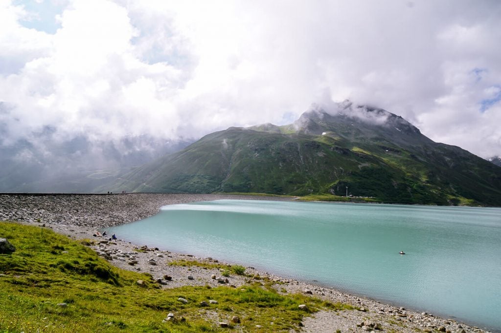
Hike along the Silvretta Staumauer (reservoir wall), hugging the milky-turquoise reservoir, and make your way to Bieltal (Biel Valley).
Follow signs to Wiesbadener Hütte. When the trail divides, follow the left trail to Wiesbadender Hütte über Bieltal (3:15 hours) and Radsattel (2:15 hours).
There are other ways to Wiesbadener Hütte, but this is the most enjoyable.
As you progress, there are spectacular views of the Verwall Alps and the serpentine Silvretta High Alpine Road (Silvretta Hochalpenstrasse).
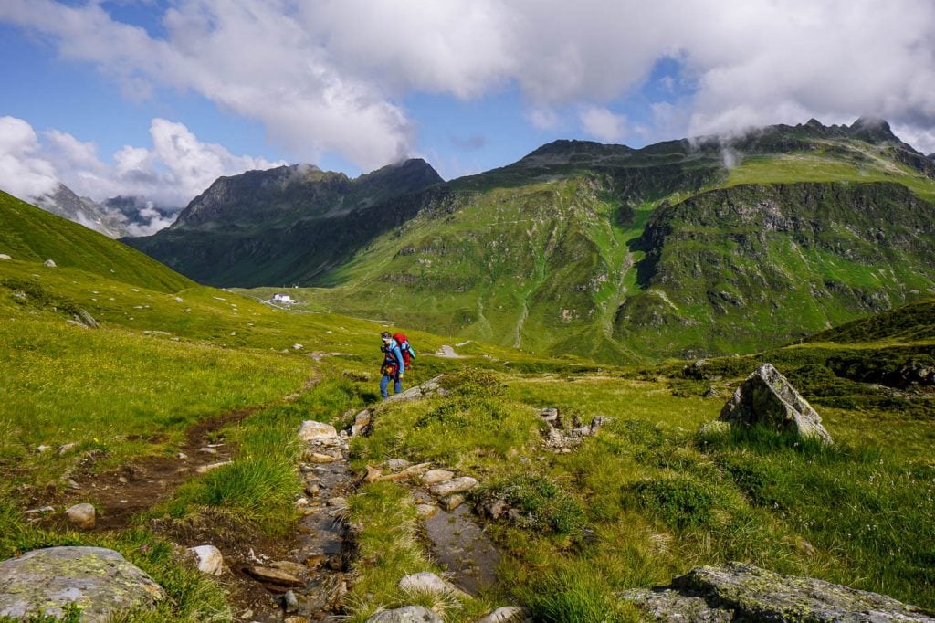
The trail gently ascends along the Bieltalbach (Biel Valley Stream) all the way up to Radsattel (2652 m).
Accompanied by the sound of running water, you’ll follow this soft valley trail for a good 1:30 hours before it steepens.
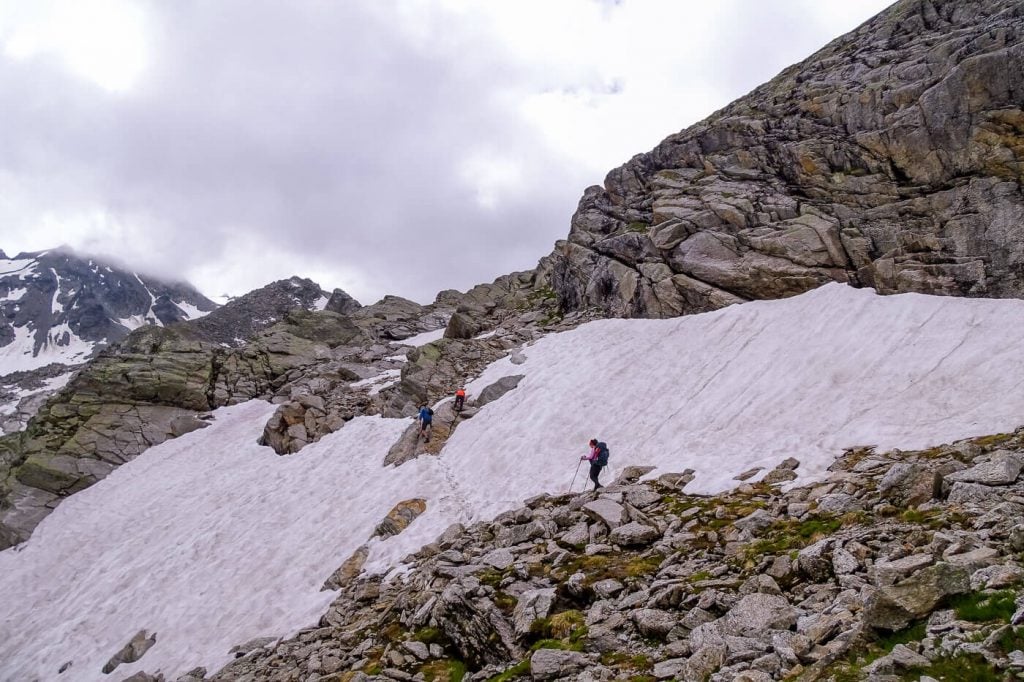
As you near the saddle, you’ll traverse some boulders and possibly a snowfield (in early summer).
There’s a small lake on your right called Radsee. Keep your eyes out for roaming Ibex. We saw at least two dozen.

The Radsattel (2652 m) is the mountain saddle between Bieltalkopf (2797 m, Biel Valley Head) and Hohes Rad (2934 m).
When you crest the saddle, you’ll be met with sweeping views of glaciated Silvretta peaks.
Optional Detour: Hohes Rad Peak

For those that want to detour to Hohes Rad peak, you can turn right at the Rad saddle and hike 30 minutes to the Radschulter (Rad Shoulder), crossing a slope of boulders.
Snow lingers along this trail into late July.
From the Radschulter (2697 m), it’s a 40-minute ascent to the peak. This trail requires scrambling, sure-footedness, and a head for heights.
There are some tricky, exposed steps as you near the summit.

The peak rewards you with panoramic views of the Oschental valley, Silvretta and Verwall mountains, and the Silvretta Stausee reservoir.

Return by the same route to the Radsattel.
Trail Stats Hohes Rad Peak Detour
Distance: 3.1 km out-and-back
Time Needed: 3 hours
Elevation Gain/Loss: 373 meters
Difficulty: Difficult
Minimum Elevation: 2618 m
Maximum Elevation: 2934 m
Radsattel to Wiesbadener Hütte (50 minutes)

From Radsattel, it’s a mere 50-minute hike to Wiesbadener Hütte.
Descend in the direction of the small pond straight ahead. Before reaching the pond, the trail splits. Follow the left trail to Wiesbadener Hütte (40 minutes).
From here, follow an undulating path, at times ascending, for the next 30 minutes.
The scenery stretches out sublimely before you, creating a visual crescendo of soaring peaks, accented by glacial ice.
It feels like you’re embarking on an epic journey with great purpose and a sense of adventure.

Ultimately, the path descends to Wiesbadener Hütte (2443 m), the impressive mountain lodge facing Piz Buin, the quickly retreating Ochsentaler and Vermunt glaciers, and the Silvrettahorn.

Wiesbadener Hütte is a managed DAV mountain hut. The hut is usually open from mid June until late September. Bring cash.
Wiesbadener Hütte is extremely popular among climbers and mountaineers, because it’s the starting point for climbs up to Piz Buin.
Wiesbadener Hütte to Silvretta Bielerhöhe (2 hours)

From the hut, descend Ochsental valley to the Silvretta Stausee. The trail is a wide gravel track, so it’s very easy walking from here on out.
When you get to Southern-tip of the Silvretta Reservoir, head right and walk along the reservoir back to the Bielerhöhe mountain pass.
Where to Stay near Silvretta Bielerhöhe
Schruns-Tschagguns, Montafon
Budget | The brand new TUI Blue Montafon hotel in Tschagguns features modern, comfortable, and quiet (sound-proof) bedrooms. Guests praise the attentiveness and friendliness of the staff. And, the breakfast buffet is excellent, offering a lot of variety and local ingredients. The hotel has an on-site restaurant (limited menu) and small spa area.
Midrange | The quaint Gasthof Löwen in Tschagguns is a traditional, family-run hotel dating back to 1500. The hotel restaurant is one of the best places to eat in Montafon. It’s also one of our favorite restaurants in all of Austria. Expect a wonderful breakfast as well. On Thursdays, the family members play traditional music in the bar. Guests also have access to the Montafoner Hof indoor-outdoor pool.
Luxury | Amrai Suites is an alpine-modern hotel in Schruns with an on-site restaurant and luxurious wellness area. Tastefully designed with natural materials and an earthy color palette, the hotel bedrooms are both calming and visually stunning. Highlights of staying here are the breakfast buffet, creative dinner menus (featuring local and fresh ingredients), and the Stólla spa oasis, which pays homage to the region’s former mining industry. It encompasses an indoor copper bath, herbal kettle sauna, Finnish sauna, steam bath, rain shower, ice fountain in the Montafon Glacier Grotto, outdoor pool, and relaxation rooms.
Look for accommodation in Schruns-Tschagguns.

GET YOUR FREE EBOOK
Signup for our newsletter to get our guide to “Secret Hiking Destinations in Europe.”
Austria Trip Planning Essentials
Use our Austria Travel Guide and Austria blog archive to plan a unique and memorable trip to Austria.
When to Visit Austria
Summer and early Fall are our favorite seasons in Austria.
Getting around Austria
Austria has an excellent public transit system. We’ve used it extensively to travel throughout the country. We highly recommend using transit if you’re visiting cities (Vienna, Salzburg, Innsbruck, Graz, etc…), and/or doing hut-to-hut hikes.
Some areas like Mayrhofen, Schladming and Lech am Arlberg have wonderful seasonal transit systems in place (e.g. summer hiking buses). However, if you’re not visiting during the high season, bus frequencies are significantly reduced and it’s far easier to get around with your own vehicle.
If you’re planning on visiting multiple destinations across Austria, we recommend renting a car.
Use these road trip itineraries for trip planning inspiration:
- 2 Week Austria Road Trip – starting in Vienna
- 1 Week Austria Road Trip – starting in Salzburg or Munich
- 10-Day Bavarian Alps & Tyrolean Alps Road Trip – starting in Munich
Car Rental
We recommend using the Discovercars.com car rental reservation platform to search for and book car rentals. This easy-to-use booking platform compares car rental deals from 500+ trusted providers, so that you can choose the best option for your trip.
If you’re driving into Austria from a neighboring country, don’t forget to purchase a vignette at/near the border.
Hiking in Austria
Where to Hike in Austria
Read Austrian Alps Hiking Destinations for an overview of where to hike in Austria, with tips on specific trails and where to stay. Also check out Best Day Hikes in Austria and these region-specific hiking guides:
- Salzburg Hiking Guide
- Filzmoos, Salzburg Hiking Guide
- Schladming, Styria Hiking Guide
- Lech am Arlberg, Vorarlberg Hiking Guide
- Vorarlberg Hiking Guide
- Vienna Mountains Hiking Guide
Hut to Hut Hiking in Austria
Austria is a premier hut-to-hut and long-distance hiking destination. The quality of the mountain huts are superb. We particularly love the high-alpine trails, which are called Höhenwege in German. We’ve summarized our favorite multi-day hikes in Trekking Austria. If you’re new to hut hiking, read this in-depth guide to Hut to Hut Hiking in Austria.
Hiking Essentials
- Day Pack: Osprey Tempest 30 Women’s Backpack / Osprey Talon 33 Men’s Backpack
- Grade B/C high-cut hiking boots: Meindl Schuhe Island Lady (Kati’s Boots), Women’s Hanwag Tatra II GTX (Sabrina’s Boots), Men’s Hanwag Tatra II GTX (men’s equivalent)
- CAT 4 Sunglasses: Julbo Shield Mountain Sunglasses
- Hiking Poles: Black Diamond Trail Trekking Poles
- Backpack Camera Clip: Peak Design Camera Clip
What to See & Do in Austria
- Visit a gorge like the Liechtenstein Gorge in Salzburg.
- Bathe in the thermal pools of an Austrian Therme like Aqua Dome in Tirol
- Stay in a thermal spa hotel like Rogner Bad Blumau in Styria, EurothermenResort Bad Ischl in Upper Austria, or the Aqua Dome Hotel in Tirol.
- Hike to a mountain lake like Lake Tappenkarsee in Salzburg or Lake Drachensee in Tirol.
- Go Wine Tasting in South Styria.
- Marvel at the culture, music, and architecture of Vienna.
- Eat heartwarming mountain food in an Almhütte at Grosser Ahornboden in Tirol or Ursprungalm in Styria.
- Drive the Grossglockner High Alpine Road in Hohe Tauern National Park.
- Visit the castles, monasteries, and wine taverns of the Wachau Valley, a UNESCO World Heritage Site.
Austrian Hotels
- Best Hotels in the Austrian Alps
- Best Hotels in Lech am Arlberg, Vorarlberg
- Wellness Hotel Theresa, Zillertal, Tirol
- Hotel Eder in Maria Alm, Salzburg
Moon & Honey Travel is an independent blog created by two passionate hikers. We are able to provide free content to you, because of ads and affiliate links. When you make a purchase using one of these links, we may receive a small commission at no extra cost to you. Happy travels and happy trails, Sabrina and Kati