Southern Peru desert shattered by the great 2001 earthquake: Implications for paleoseismic and paleo-El Niño–Southern Oscillation records (original) (raw)
Abstract
In the desert region around the coastal city of Ilo, the great southern Peru earthquake of June 23, 2001 (8.2–8.4 moment magnitude), produced intense and widespread ground-failure effects. These effects included abundant landslides, pervasive ground cracking, microfracturing of surficial hillslope materials, collapse of drainage banks over long stretches, widening of hillside rills, and lengthening of first-order tributary channels. We have coined the term “shattered landscape” to describe the severity of these effects. Long-term consequences of this landscape shattering are inferred to include increased runoff and sediment transport during postearthquake rainstorms. This inference was confirmed during the first minor postearthquake rainstorm there, which occurred in June and July of 2002. Greater amounts of rainfall in this desert region have historically been associated with El Niño events. Previous studies of an unusual paleoflood deposit in this region have concluded that it is the product of El Niño-generated precipitation falling on seismically disturbed landscapes. The effects of the 2001 earthquake and 2002 rainstorm support that conclusion.
On June 23, 2001, the moment-magnitude (Mw) 8.2–8.4 southern Peru earthquake caused widespread ground failures throughout a region at least 400 km long and 120 km wide (1). The variety and intensity of these effects in an area near the southern end of the earthquake fault rupture, seldom if ever observed in previous earthquakes, has led us to coin the term “shattered landscape” to describe their consequences. Elements of this shattered landscape include abundant landslides, pervasive ground cracking, microfracturing of surficial hillslope materials, collapse of drainage banks, widening of hillside rills, and lengthening of first-order tributary channels.
In addition to studying the impact of the earthquake itself, we witnessed effects of the first postearthquake rain to fall on this desert landscape. Precipitation from this rainstorm demonstrated that such earthquake effects greatly exacerbate runoff, sediment transport, and flooding during the rare episodes of rainfall that occur there. Consequently, our field studies provide a direct modern analog for interpreting the El Niño–Southern Oscillation-generated paleoflood record in this arid region, especially as it relates to inferred combined effects of earthquakes and El Niño occurrences.
The purposes of this article are first to describe the shattered-landscape effects produced by the 2001 earthquake, then to describe the effects of the first postearthquake rainstorm there, and finally to discuss implications of these observations for interpreting the paleoseismic and paleoflood (paleo-El Niño–Southern Oscillation) records in this region.
Regional Setting and Earthquake Occurrence
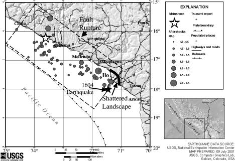
The seismotectonic setting of Peru is controlled largely by the convergence of the Nazca and South American tectonic plates. These two plates are converging at a rate of ≈78 mm/year, with the Nazca plate moving relatively eastward and subducting beneath the North American plate (2). Most of the relative plate motions are accommodated by slip on an easterly dipping thrust fault at the interface between these two plates, at which the 2001 earthquake occurred (3, 4). This fault steepens from north to south, and south of 15°S latitude, the Nazca plate has subducted to a depth of 200 km over a horizontal distance of ≈350 km (4). The earthquake was produced by rupture of a portion of the fault interface that was ≈200–370 km long and ≈100–160 km wide (4, 5) (Fig. 1). This fault rupture is entirely within the inferred fault rupture of the great southern Peru earthquake of 1868 (Mw 8.8) (4). Other great historical earthquakes along the southern Peru segment of the convergence zone occurred in 1604 (Mw 8.7), 1687 (Mw 8.4), and 1784 (Mw 8.4), and thus the recurrence interval for great earthquakes in this southern Peru region is evidently on the order of a century (6).
Fig. 1.
Location of the seismically shattered desert landscape in southern Peru; epicenter and main aftershocks of the June 23, 2001, earthquake and principal cities in the region (from the U.S. Geological Survey); inferred fault rupture of the 2001 earthquake (from ref. 5); and inferred epicenter of the 1604 earthquake (from ref. 18).
The southern Peru earthquake of June 23, 2001, had an Mw of 8.2–8.4. The hypocenter was 30- to 33-km deep and located near the coast at 16.26°S, 73.64°W (4) (Fig. 1). Much of the energy release and the largest aftershock (Mw 7.6) occurred far to the southeast of the hypocenter, in the part of the fault-rupture zone nearest the study area of shattered-landscape effects (4). Within Peru, the earthquake shaking was recorded on only one strong-motion instrument, located in the city of Moquegua, ≈60 km NNE of the city of Ilo, which is in the center of the study area. There the peak ground acceleration was a moderate to high 0.30 × g, and the significant duration was a relatively short 36 sec (7). Damage in the central part of Ilo, in which bedrock is at or near the ground surface, was minimal, whereas in outlying areas built on softer materials, local damage ranged from minimal to severe (7). The regional-scale mapping of seismic intensities (5) rated the maximum earthquake shaking intensity as a modified Mercalli (MMI) VIII (relatively low for an earthquake of this magnitude) and intensities within the study area as MMI VII–VIII. However, the intensity of the shattered-landscape effects suggests that shaking was more severe locally than indicated by this regional-scale mapping.
The study area extends for a distance of ≈80 km along the coast around the city of Ilo and for several kilometers inland (Fig. 1). The main physiographic features in this area are a sea cliff of variable height, a narrow coastal plain, a series of prominent alluvial fans drained by incised “quebradas” (arroyos, or normally dry drainage channels), and the Coastal Cordillera, a mountain range on which the highest peaks are 1,600–1,800 meters above sea level. Midway through the study area, the Osmore drainage basin, which cuts through the Coastal Cordillera to the high Andes, meets the sea at the port city of Ilo (Fig. 1). Rocks making up the Coastal Cordillera are generally well indurated, but in many places they are intensely fractured or exhibit multiple sets of prominent, open joints, which are characteristics that make them highly susceptible to seismically generated rock falls and rock slides (8). Many of the slopes are also covered with colluvial soils.
The large alluvial fans that mantle the lower cordilleran slopes are composed of poorly to moderately consolidated flood and debris-flow deposits interbedded with cohesionless, aeolian sands. The fans are formed largely by sediment carried through many short and steep quebrada drainages that descend the seaward slope of the coastal mountains. Having cut through their own older deposits, these quebradas are now deeply incised and steep-sided, generally carrying runoff only during El Niño events. The uppermost layer in both fan sediments and hillside colluvium is typically a crust, consolidated by desiccation, in which shattered-landscape effects were especially well preserved.
The climate in the study area is hyperarid. Winter fogs along the coastal plain produce mean annual precipitation of only a few millimeters per year, with precipitation typically increasing somewhat as elevation increases on the seaward flank of the Coastal Cordillera. Vegetation is absent or sparse except in scattered lomas plant communities, in which winter-fog condensation supports seasonal foliage blooms at altitudes of ≈200–1,500 m. Significant precipitation is generally associated only with robust El Niño conditions that endure for months and may produce several episodes of rainfall of varying duration and intensity. Such conditions, associated with El Niño events rated as “strong” or “very strong” have struck the coast of Peru and Ecuador with an average recurrence interval of ≈11 years during the period between 1925 and 1982 (9). However, El Niño-induced rainfall and flooding is typically most severe along the coast of northern Peru and Ecuador, and the recurrence interval for such effects along the south coast is currently poorly known. El Niño events are known to have caused significant rainfall and flooding throughout the study area in 1982–1983, 1992–1993, and 1997–1998 (10–13).
The Shattered Landscape
Whereas landslides and related ground failures were widespread as a result of the 2001 earthquake, they were particularly severe in two widely separated areas (1). The first of these areas was near the epicenter and the northern edge of the fault rupture, where abundant and relatively large landslides occurred along a 20-km-long stretch of the Pan American Highway (1). The second area, separated from the first by almost the entire length of the fault rupture (Fig. 1), was the area of shattered-landscape effects described herein. These shattered-landscape effects included abundant landslides, pervasive ground cracks, ridge-flank areas in which the ground was shattered down to the millimeter scale, collapsed drainage-channel banks, widened hillside rills, and drainage channels lengthened by the collapse of shallow, subsurface feeder “pipes.”
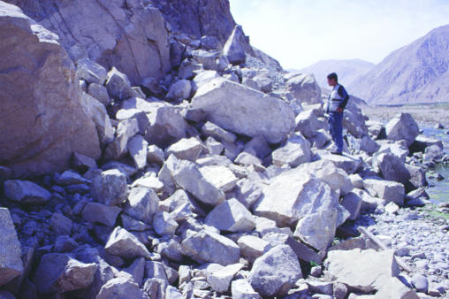
Within the shattered landscape, landslides occurred on steep artificial cuts such as for roads, as well as on valley walls, and drainage channel (or quebrada) banks (Fig. 2). Most landslides were rock falls, rock slides, soil falls, or disrupted soil slides (fast-moving, shallow, highly disrupted landslides that typically carry boulders, rock fragments, small blocks of poorly consolidated material, and loose sediment relatively long distances down steep slopes). Most landslides of these types in the study area had volumes in a range between 1 and 1,000 m3. Where landslides were most abundant, they occurred at intervals of a few tens to hundreds of meters along stream and quebrada channels, delivering on the order of several hundred cubic meters of landslide material to each linear kilometer of channel.
Fig. 2.
Rock fall in the lower Ilo valley, one of several thousand mostly disrupted landslides triggered by the 2001 earthquake.
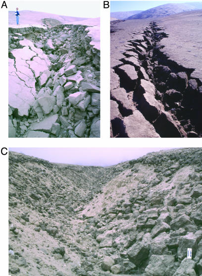
Banks of quebradas incised into coastal alluvial fans and foothills experienced pervasive collapse, which widened the upper portions of the channels while choking the channel bottoms with sediment (Fig. 3). In areas of the most intense collapse, several thousands of cubic meters of loose sediment were delivered to the bottom along each linear kilometer of quebrada channel. Typical stratigraphy exposed in the areas of collapse consisted of a three-layer sequence. The upper layer was a 10- to 50-cm-thick cohesive crust of aeolian sand, evidently held together by negative pore-water pressures (soil suction). Underlying this crust was a thinner, heavily structured, black organic lomas soil, and below that was a variable sequence of cohesionless aeolian sands interbedded with coarser and more consolidated flood and debris-flow deposits extending to the channel bottoms. In areas of bank collapse, the more cohesive crust and lomas soils typically formed blocks several tens of centimeters on a side, whereas cohesionless underlying materials formed sheets of loose sediment (Fig. 3).
Fig. 3.
Collapsed quebrada banks in the shattered landscape. (A) Collapse of banks composed of cohesive crust underlain by largely cohesionless sand produced a deposit consisting of a mixture of large blocks and sheets of loose, fine sediment. The scale shown is marked in inches and centimeters. (B) Detachment of large polygonal blocks, on the order of 1 m long, significantly widened this quebrada channel while also providing substantial amounts of sediment for entrainment by postearthquake runoff. Dark patches on the ridge in the background are zones of shattered ground. (C) Sediment from seismically shattered banks choking the bottom of a quebrada. The scale shown is marked in inches and centimeters.
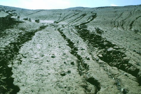
Upslope from most quebradas, hillsides are incised by systems of shallow rills, 10–25 cm deep, which are linear and trend down the local gradient. These rills channel runoff along with any entrained sediment from the hillslopes into the quebradas during rainstorms. Rills, too, experienced extensive caving of their banks, thus widening them and increasing their capacity to transport runoff and sediment from hillslopes to quebradas (Fig. 4). In some areas, rills were connected to quebrada channels by systems of short, underground natural conduits or pipes, generally cut into or through the lomas soil and having roofs composed of cohesive crust. The earthquake also caused such pipes to collapse, thus adding to the length of existing quebradas.
Fig. 4.
Multiple rills widened by earthquake-induced collapse of their banks. Rills in the foreground are ≈0.1–1.0 m wide.
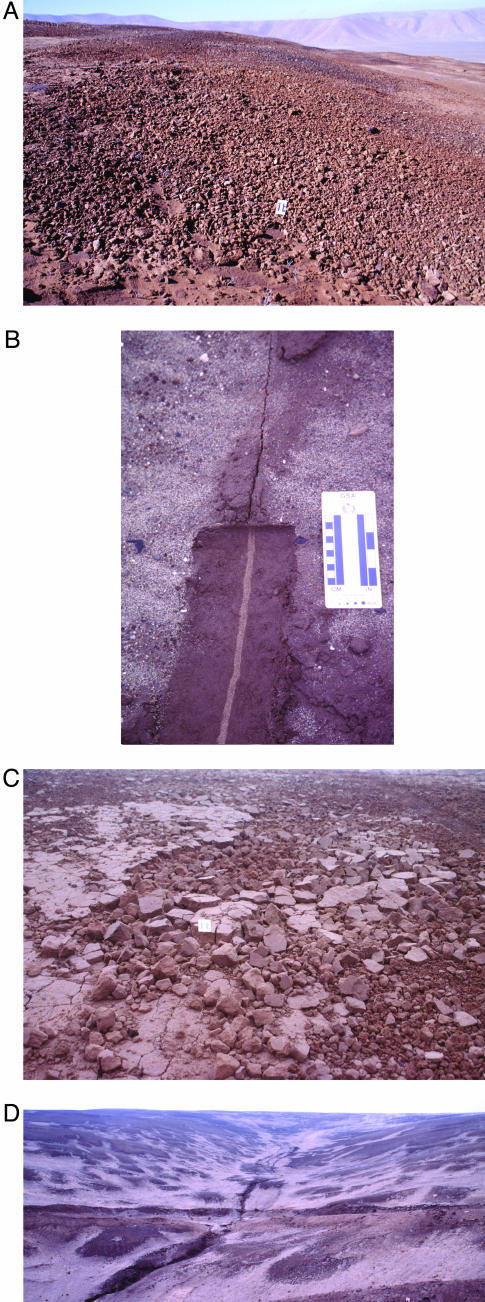
Many hillslopes in both alluvial fan and foothill areas contained zones in which at least the cohesive surface crust and lomas soil were cracked or shattered. Intensities ranged from zones with cracks spaced on the order of 1 m apart to microfracturing of the soil into fragments only a few millimeters on a side (Fig. 5). In areas of the least intense cracking, ground was broken into polygonal blocks separated by fissures a few millimeters to more than 1 cm wide, and the surface resembled a jigsaw puzzle in which the pieces did not quite fit together. A few shallow excavations showed that at least some fissures were coincident with older cracks that were filled with aeolian sand (Fig. 5_B_). Whereas the extent of this coincidence in location is unknown, the colocation of at least some ground cracks from the 2001 earthquake with older cracks suggests that this seismic shattering has been a recurrent phenomenon.
Fig. 5.
Zones of cracked and shattered ground on ridge flanks. (A) Zone in which surficial materials have been shattered into fragments a few millimeters to a few centimeters on a side. The scale shown is marked in inches and centimeters. (B) An earthquake-induced ground crack (upper part of photograph) follows the trace of an older ground crack filled with aeolian sand (light material in lower part of photograph), as shown in shallow excavation. The scale shown is marked in inches and centimeters. (C) Zone of cracked ground grading into a zone of shattered earth. The scale shown is marked in inches and centimeters. (D) Closely spaced zones of shattered ground (dark areas) on hillslope. Note the unpaved road traversing the central part of the photograph for scale.
Many zones of hillside cracking graded into areas of thoroughly shattered earth (Fig. 5_C_), in which the surficial crust and lomas soil had been fractured down to the millimeter scale, producing a chaotic jumble of small fragments. This fracturing was so violent that small lomas plants were uprooted and thrown out of the ground. Zones of the most thoroughly shattered earth were concentrated on the downslope flanks of small-scale, local topographic convexities. Some ridge flanks had many areas of ground cracks and shattered earth spaced at close intervals (Fig. 5_D_).
Effects of the June–July 2002 Rainfall
During late June and early July of 2002, a large, anomalous cold front stalled over central and southern Peru. This front disrupted the coastal temperature inversion that normally inhibits precipitation in the desert and produced the first rainfall in the Ilo region since the 2001 earthquake. Coastal fog was dense and typically thickened at higher altitudes along the seaward flank of the Coastal Cordillera in late afternoons and evenings. Light, nighttime showers occurred several times. On the afternoon and throughout the night of July 2–3, rain fell for several hours throughout the Cordillera and along the coastal plain. Observing the rain in Ilo, we estimate that total precipitation of ≈6–12 mm occurred there, although no quantitative measurements of the rainfall are available. Precipitation was undoubtedly greater at higher elevations in the Coastal Cordillera, where many quebrada drainages have their headwaters. As one of the effects of the rainfall high in the Cordillera, we observed a flash flood wave in a quebrada ≈25 km south of Ilo on the afternoon of July 2. The wave, which was ≈0.5 m high and several meters wide, was observed when only a trace of rainfall had yet occurred on the coastal plain itself.
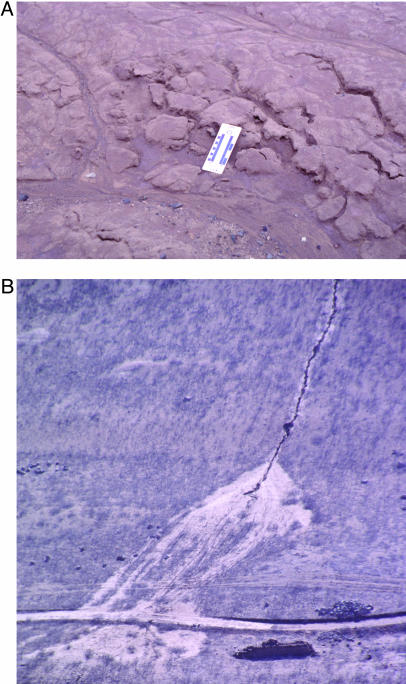
After the July 2–3 showers, our field observations revealed that even this small amount of precipitation had significant effects on the shattered landscape. It caused runoff, erosion, and sediment transport through all parts of the coastal drainage system from cracked and shattered hillsides, through widened rills and conduits, into collapsed quebrada channels, and down to the sea. Excavations revealed that rain infiltrated into the soil to an average depth of ≈10 cm on hillsides. Ground cracks produced by the earthquake served as small channels for runoff, which rounded the previously sharp edges of blocks and entrained sediment from their edges (Fig. 6_A_). In areas of shattered earth, the runoff transported shattered fragments of soil downslope. In areas where runoff was concentrated, new gullying was initiated in areas that previously lacked rills. Where the earthquake had widened existing rills, runoff through them created new sediment deposits (Fig. 6_B_). Concentrated runoff flowing through collapsed pipes and quebrada channels transported sediment along them also, in some cases winnowing out the fine material from earthquake-induced bank collapses and leaving coarse lag deposits behind. After the rainfall episode, water continued to trickle down some quebrada channels for several days.
Fig. 6.
Effects of the June–July 2002 rainfall event on the shattered landscape. (A) Earthquake-induced ground cracks provided channels for runoff, which eroded the edges of polygonal blocks and entrained sandy sediment in flow. The scale shown is marked in inches and centimeters. (B) Fan-shaped deposit of sediment (light-colored material) washed over an unpaved road from an earthquake-widened rill.
Long-Term Consequences of Seismic Shattering, the 1604 Earthquake (Mw 8.7), and the Paleoflood (Paleo-El Niño–Southern Oscillation) and Paleoseismic Records
The various components of the seismically shattered landscape are inferred to have at least two important effects on long-term landscape evolution. First, the seismic shattering enlarges channels in the upstream portions of drainage systems, and this enlargement in turn increases the capacity of the channels to carry runoff. Second, this seismic shattering of the landscape detaches vast amounts of loose material from hillsides and channel banks, thereby increasing the amount of sediment available for transport by that runoff. Taken together, these seismic effects prime the landscape for severe postearthquake flooding and erosion.
Previous work (10–14) has identified several paleoflood deposits in the study area, one of which, the “Chuza” paleoflood unit, is inferred to have been produced by a severe El Niño-generated flood in 1607–1608 (10, 11, 14). This El Niño event occurred only ≈3 years after the great earthquake of November 24, 1604, which was larger (Mw 8.7) (6) than the 2001 earthquake and had an epicenter much closer to the study area (Fig. 1). In 1604, “great” landslides were reported throughout the region south from latitude 15.5°S through the study area to Arica, Chile (6). Historical damage accounts indicate that shaking in the study area was substantially more severe in 1604 than in 2001 (15). Consequently, we infer that shattered-landscape effects in 1604 were even more intense and abundant than in 2001.
Characteristics of the Chuza paleoflood unit are consistent with its generation by a severe flood acting on a seismically shattered landscape (12, §). These characteristics are as follows. (i) The unit is particularly thick, with measured thicknesses as great as 1.4 m (10, 12). (ii) The unit is one of the two most geographically extensive in the study area (10–13), suggesting particularly abundant and widespread runoff from seismically shattered channels. (iii) The matrix is distinctively coarse-grained, with ≈40–90% of the particles being gravel-sized or larger (12). In particular, the matrix contains abundant angular rock fragments (10), as would be generated by earthquake-induced rock falls and rock slides in source rocks such as are common throughout the Coastal Cordillera. (iv) Massive bedding and good preservation of plant materials suggest that the ratio of solid material to incorporated fluid was relatively high, indicating that unusually high volumes of sediment were available for transport.
Paleoflood deposits with characteristics similar to those of the Chuza paleoflood unit are likely to be the best preserved evidence of seismic landscape shattering, because many of the shattered-landscape effects themselves are highly prone to destruction by rainfall and runoff. Thus the identification and dating of such deposits can provide information about the dates and recurrence of large prehistoric earthquakes and of floods that may be unusually severe because the floodwaters are acting on a landscape that has been seismically shattered. Four older paleoflood units with similar characteristics have been identified in the study area at the site of Quebrada Tacahuay (12). Those deposits, dated to ≈5,300, 11,600–12,000, and between 12,900 and 38,200 calendar years before present (12), suggest the occurrence of four previous great earthquakes that produced shattered landscapes.
The character of the Chuza and the four older paleoflood units indicates that seismic shattering is a recurrent phenomenon in this region. The landscape in this region may be particularly susceptible to seismic shattering because of its position at the margin of a major fault segment that generates great earthquakes (4–6). This landscape may also be particularly susceptible because of the hyperarid conditions, which are associated with widespread desiccated crusts, abundant steep slopes and dry drainage banks, and lack of vegetative cover. However, it is possible also that such seismic-shattering effects are more common than is currently known because detailed studies of ground-failure effects have been carried out for only a few earthquakes as large as that of 2001 (16). In one of the few such studies, substantial El Niño-induced transport of sediment from earthquake-induced landslides was documented after another great Peruvian earthquake, the Mw 7.9 Río Santa earthquake that occurred in central Peru in 1970 (17).
Summary and Conclusions
The great Mw 8.2–8.4 earthquake of June 23, 2001, produced a widespread shattered landscape in the area around Ilo, Peru. Widely distributed elements of the seismically shattered landscape included abundant landslides, pervasive ground cracking, and zones of microfractured earth in which surficial materials were shattered down to the millimeter scale. Elements that specifically affected the regional drainage system included quebrada banks that collapsed over long stretches, widened hillside rills, and drainage channels that were lengthened by collapsed natural subsurface conduits leading into them. This shattered landscape generated large amounts of loose surficial material and enlarged the lowest-order components of the regional drainage system itself. Therefore, the potential for both runoff and sediment transport during subsequent floods was enhanced, as was demonstrated during the first episode of postearthquake rainfall.
The seismic shattering of the landscape by the 2001 earthquake explains anomalous characteristics of a paleoflood deposit in this region that was probably generated in 1607–1608, ≈3 years after another great earthquake. Nearly all rainfall in this region is produced by El Niño events. The combination of seismic landscape shattering and El Niño events can evidently produce unusually severe flooding, with particularly large amounts of both runoff and sediment transport. Recognizing paleoflood deposits that result from such a combination of events can help identify and date both prehistoric earthquakes and prehistoric floods. Understanding the seismic-shattering phenomenon thus has implications both for evaluating present-day risk from earthquakes and floods and for determining the possible effects of natural disasters in the prehistoric record.
Acknowledgments
Engineer Ralph Stricklen, of Ilo, Peru, discovered the shattered landscape and called it to our attention. He and Helen Stricklen also provided extraordinary hospitality and logistical support during our fieldwork. Randall Jibson, James B. Richardson III, Catherine Rigsby, and Mary Lou Zoback (National Academy of Sciences Section 15) thoughtfully reviewed and thus greatly improved the article.
Abbreviation: Mw, moment magnitude.
Footnotes
§
Keefer, D. K., Moseley, M. & Satterlee, D. (1996) Geol. Soc. Am. Abstr. Programs 28 (7), A301 (abstr.).
References
- 1.Wartman, J., Rodriguez-Marek, A., Repetto, P. & Keefer, D. (2003) in Southern Peru Earthquake of 23 June 2001 Reconnaissance Report, Earthquake Spectra, eds. Rodriguez-Marek, A. & Edwards, C. (Earthquake Engineering Research Institute, Oakland, CA), Suppl. A to Vol. 19, pp. 35–56. [Google Scholar]
- 2.Demets, C., Gordon, R., Argus, D. & Stein, S. (1990) Geophys. J. Int. 101**,** 425–478. [Google Scholar]
- 3.Leffler, L., Stein, S., Mao, A., Dixon, T., Ellis, M., Ocola, L. & Selwyn Sacks, I. (1997) Geophys. Res. Lett. 24**,** 1031–1034. [Google Scholar]
- 4.Dewey, J. W. (2003) in Southern Peru Earthquake of 23 June 2001 Reconnaissance Report, Earthquake Spectra, eds. Rodriguez-Marek, A. & Edwards, C. (Earthquake Eng. Res. Inst., Oakland, CA), Suppl. A to Vol. 19, pp. 1–10. [Google Scholar]
- 5.Tavera, H., Buforn, E., Bernal, I., Antayhua, Y. & Vilacapoma, L. (2002) J. Seismol. 6**,** 279–283. [Google Scholar]
- 6.Dorbath, L., Cisternas, A. & Dorbath, C. (1990) Bull. Seismol. Soc. Am. 80**,** 551–576. [Google Scholar]
- 7.Rodriguez-Marek, A., Williams, J., Wartman, J. & Repetto, P. (2003) in Southern Peru Earthquake of 23 June 2001 Reconnaissance Report, Earthquake Spectra, eds. Rodriguez-Marek, A. & Edwards, C. (Earthquake Eng. Res. Inst., Oakland, CA), Suppl. A to Vol. 19, pp. 11–34. [Google Scholar]
- 8.Keefer, D. K. (1993) Bull. Assoc. Eng. Geol. 30**,** 353–361. [Google Scholar]
- 9.Quinn, W. R. & Neal, V. (1995) in Climate Since A.D. 1500, eds. Bradley, R. & Jones, P. (Routledge, London), pp. 623–648.
- 10.Satterlee, D. R. (1993) Ph.D. dissertation (Univ. of Florida, Gainesville).
- 11.Satterlee, D. R., Moseley, M., Keefer, D. & Tapia, J. (2001) Andean Past 6**,** 95–116. [Google Scholar]
- 12.Keefer, D. K., Moseley, M. & deFrance, S. (2003) Palaeogeogr. Palaeoclimatol. Palaeoecol. 194**,** 41–77. [Google Scholar]
- 13.Moseley, M. E. & Keefer, D. (2004) in El Niño, Catastrophism, and Culture Change in Ancient America, Proc., eds. Sandweiss, D. H. & Quilter, J. (Dumbarton Oaks, Washington, DC), in press.
- 14.Moseley, M. E., Tapia, J., Satterlee, D. & Richardson, J., III (1992) in Paleo-ENSO Records International Symposium Extended Abstracts, eds. Ortlieb, L. & Macharé, J. (ORSTOM, Lima, Peru), pp. 207–212.
- 15.Guzmán, A. M., Fidel, L., Zavala, B., Valenzuela, G. O., Núñez, S. & Pari, W. (2000) Estudio de Riesgos Geológicos del Perú Franja No. 1 (Instituto Geológico Minero y Metalúrgico, Lima, Peru), Boletin 23.
- 16.Keefer, D. K. (2002) Surv. Geophys. 23**,** 473–510. [Google Scholar]
- 17.Moseley, M. E., Wagner, D. & Richardson, J. B., III (1992) in Paleoshorelines and Prehistory: An Investigation of Method, eds. Johnson, L. L. & Stright, M. (CRC, Boca Raton, FL), pp. 215–235.
- 18.Silgado, E. F. (1978) Historia de los Sismos mas Notables Ocurridos en el Peru (1513–1974) (Instituto de Geología y Mineria, Lima, Peru), Boletin 3.
