Kansas City District > Locations > District Lakes > Wilson Lake > Learn About the Lake (original) (raw)

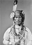
Over 400 years ago Spaniards led by Coronado were the first White Men to explore this area. They entered Kansas along the southern border where Clark County is now located, moving to Dodge City then to Great Bend and on Northeast. They found this area to be the home of the Pawnee Indians, also known as the Quiviras. Farther to the West roamed the Comanches. The Pawnees, according to tradition were of Southern origin. They roamed over the entire area from the Missouri River to the Rocky Mountains. Many of the Native American Indian writings were to be found in the area of hills surrounding Lake Wilson. The Pawnees were very capable in their imitation of animals. In ancient times they had no horses and hunted on foot. They used arrowheads made of flint or deer antler.
Otoe Park was named for the Otoe Indians that occupied this area. Minooka Park was named for the Otoe Indian word Mi-Nook-A, meaning “Good Earth.”

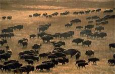
Vast herds of bison and pronghorn once roamed this flowing mixed-grass prairie, where precipitation ranges between 20-30 inches a year. (This was hunting grounds for the Cheyenne and the Pawnee.) Coronado (1541), Bourgmont (1724), Pike (1806), Jedediah Smith (1824), and Fremont (1843) explored these hills, and the first permanent settlers arrived in 1855. The Smoky Hills are comprised of three upland regions of Cretaceous age: the Niobrara Chalk, Greenhorn Limestone (Post Rock), and the Dakota Sandstone regions.
Pawnee Trail travelers: Pedro de Villasur 1720, Etienne Veniard de Bourgmont 1724, Mallet Brothers 1739, Zebulon Pike 1806, David Meriwether 1820, Charles Augustus Murray 1835, and John C. Freemont 1842-1853.
Francisco Vasquez de Coronado and retinue of 30 men were the first Europeans to see central Kansas in the 1500’s. He found literally an ocean of grass, with springs and seeps that fed the rivers. On the journey in search of the mythical seven cities of gold Coronado found many small tribal groups who had no permanent homes, but lived by following the migrating bison and elk herds. They had conical skin tepees, bows and arrows, leather clothing and they used large dogs as burden animals. They were nomadic hunter/gatherers of many different tribal ancestries.

As the Spanish developed the south (old Mexico territory) they introduced horses. It is believed that the horses in some cases formed wild bands and spread rapidly northward, but Native Americans of the south were led to believe horses were “man-eaters” and were feared. They later turned to raiding the Spanish for their horses, at first as an easy source of food. In a lesser part horses were introduced in the colonial east from the English and from the French in Canada in years to come. Hundreds of nomadic tribes eventually evolved to customized horseback and horses were stolen from one Indian group to another across the plains, which was faster than Anglos could document. Pawnee tribes of Nebraska and Kansas began taking Apache slaves to trade with the French of the north. The Pawnees so hated the Apaches that captive women and children were often eaten!
All of the different tribal groups rapidly formed an entirely different culture, dependent on the horse and bison. Game was plentiful, but the problem along the Saline River Valley was increased battle skirmishes caused by so many tribes crowded in the area. Smallpox and measles from the European Spaniards of Mexico destroyed the Plains tribes more viciously than armed conflict. It was a period of glory before doom: the doom of disease, and the doom of ‘Manifest Destiny’ which stated that God had given Europeans a destiny to civilize North America by seizing the land and destroying native peoples. Petroglyphs of the Saline River Valley are the only remains of that capture the romance of the history of the horse, buffalo, Indians, and their predecessors. They silently depict the environment of the hunt, the raid, the freedom, the beauty, and the spirituality of their creators.
(1991 National Park Service Study, Senator Dole’s effort to create KS’s first Nat. Rec. Area)
One petroglyph site at Wilson Lake has “autographs” of notable persons such as William Cody, Wild Bill Hickock, and Frank and Jesse James. These signatures were noted as early as the 1947 report. Current speculation is that they are forgeries. Blakeslee of Wichita State University’s 1986 study reported that this site is now underwater.
The earliest contacts between Native Americans and European Americans around the Wilson Lake area were contacts with fur trappers and explorers. The explorers traversing this area were seeking routes to Spanish/Mexican territories near Santa Fe. For example, it appears that Zebulon Pike crossed the Saline River twice in 1806 as he searched for the headwaters of the Arkansas River. (In his 1986 archeological survey of Wilson Lake, Donald Blakeslee refers to evidence that suggests that Pike and his company, while following the Pawnee Trail, crossed the Saline River at the spot where the dam is now located.) The Pawnee Trail was an important early route to the southwest. Ultimately, however, the trail to Santa Fe, one of the most important routes of commerce, was located well south of present day Wilson Lake.

Rock-filled burial mounds date to between AD 1 and AD 900. The Kansas State Archeologist, Thomass Witty, who was the principal investigator of a 1960 study of the area, identified a rock shelter that he believed was used by several successive groups. Many of the small caves in the area contain evidence of use during prehistoric times, though that evidence suggests that most of the caves were used only occasionally and for very short periods (Blakeslee, 1986). “Circle Rock,” has been included on the National Register of Historic Places as part of a thematic Rock Art nomination. This nomination, which includes 30 sites in nine counties, was determined to be of “national significance” by the State Historic Preservation Officer. However, Circle Rock was one of five sites in that nomination that were rated “poor” in quality, having suffered damage from the waters of Wilson Lake and from vandalism. In his book, Kansas Rock Art, Brian O’Neill states that Circle Rock has been partially submerged by the waters of Wilson Lake.
Significance: While not common throughout the state, the majority of petroglyph sites are located in the Smoky Hills, due to the geology of the region. Petroglyphs from Early Ceramic (AD 1 – 900) and Middle Ceramic (AD 900 – 1500)
In his report, Along the Pawnee Trail: Cultural Resource Survey of Wilson Lake, Kansas, Donald Blakslee states, “Before the opening of the Santa Fe Trail in 1821, the most important route across the Plains to the Southwest followed a different course. There was an Indian trail that led from the Grand Island on the Platte River in Nebraska along a southwesterly course to the Great Bend of the Arkansas River.” Blakeslee identifies this trail as the Pawnee Trail and documents its existence by relating the stories of the explorers and traders who used it from 1739 to 1853. He then stated “it is now possible to trace the route accurately and to document that the Pike expedition crossed the Saline River near present day Wilson Dam in 1806 while on their search for the headwaters of the Arkansas River.

European American settlers began moving into the region soon after Kansas became a territory. In the 1860’s the Homestead Act was formed to increase westward expansion by offering tracts of free land in return for settlement. In the 1870’s, railroads reached the area and large numbers of immigrants from Europe began to arrive. Large colonies of Germans and Bohemians settled in the area around what is now Wilson Lake. The town of Wilson later became known as the Czech capitol of Kansas.

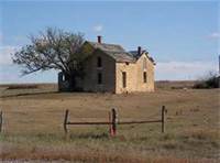
The settlers changed the landscape, converting prairie to pasture and croplands. The landscape also necessitated adaptations on the part of the settlers. On the nearly treeless prairie, alternate sources of building materials were needed. The local solution was to use the abundant and easily quarried limestone to build homes, schools, businesses, and fence posts. Because of its wide spread use as fence posts, the rock became known as post rock, and has become a symbol for the region around Wilson Lake.