Reference Elevation Model of Antarctica – Polar Geospatial Center (original) (raw)
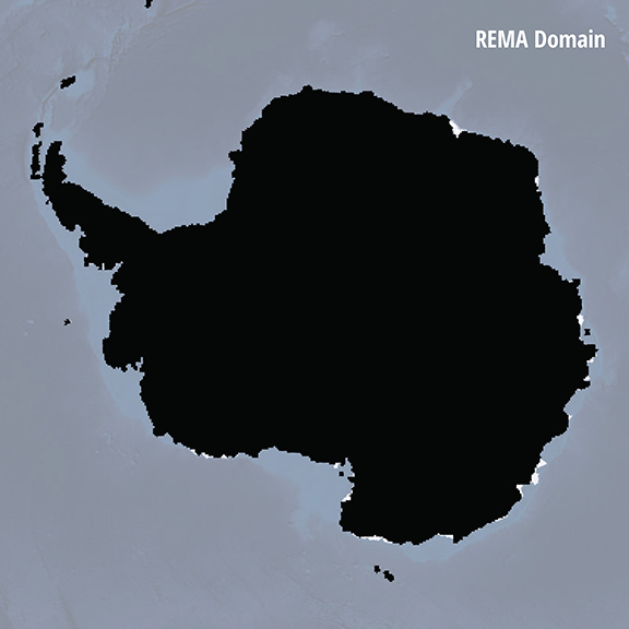
The Reference Elevation Model of Antarctica (REMA) is a high resolution, time-stamped Digital Surface Model (DSM) of Antarctica at 2-meter spatial resolution.
Want to jump right to the data?
We encourage you to read this page, but access links are provided below.
Purpose
The Reference Elevation Model of Antarctica (REMA) provides the first, high resolution (2-meter) terrain map of nearly the entire continent. Since each REMA grid point has a timestamp, any past or future point observation of elevation provides a measurement of elevation change.
REMA may provide corrections for a wide range of remote sensing processing activities, such image orthorectification and interferometry, and provide constraints for geodynamic and ice flow modeling, mapping of grounding lines, and surface processes. REMA also provides a powerful new resource for field logistics planning.
Source
REMA is constructed from hundreds of thousands of individual stereoscopic Digital Elevation Models (DEM) extracted from pairs of submeter (0.32 to 0.5 m) resolution Maxar satellite imagery, including data from WorldView-1, WorldView-2, and WorldView-3, and a small number from GeoEye-1, acquired between 2009 and 2021 over the austral summer seasons (mostly December to March).
Each individual DEM was vertically registered to satellite altimetry measurements from Cryosat-2 and ICESat, resulting in absolute uncertainties of less than 1 m over most of its area, and relative uncertainties of decimeters.
Processing
REMA is generated by applying fully automated, stereo auto-correlation techniques to overlapping pairs of high-resolution optical satellite images.
Using the open source Surface Extraction from TIN-based Searchspace Minimization (SETSM) software, developed by M.J. Noh and Ian Howat at the Ohio State University, stereopair images were processed to Digital Elevation Models using compute resources provided through an Innovation Allocation on the Blue Waters supercomputer located at the National Center for Supercomputing Applications at the University of Illinois at Urbana-Champaign.
Output
Output DEM raster files are being made available as both “strip” files as they are output directly from SETSM that preserve the original source material temporal resolution, as well as mosaic files that are compiled from multiple strips that have been co-registered, blended, and feathered to reduce edge-matching artifacts.
The time-dependent nature of the strip DEM files allows users to perform change detection analysis and to compare observations of topography data acquired in different seasons or years. The mosaic DEM tiles are assembled from multiple strip DEMs with the intention of providing a more consistent and comprehensive product over larger areas, while also providing a time stamp and error estimate for each pixel to enable to change detection. The tile data are registered to satellite altimetry to increase their absolute accuracy while strips are not. Registration data for strips may be provided in later REMA versions.
Documentation
Refer to these documents and guides for official REMA information & citation.
Citation
Along with acknowledging the PGC, the REMA dataset should be cited as follows:
Strips:
Howat, Ian, et al., 2022, “The Reference Elevation Model of Antarctica – Strips, Version 4.1”, https://doi.org/10.7910/DVN/X7NDNY, Harvard Dataverse, V1, [Date Accessed].
Mosaics:
Howat, Ian, et al., 2022, “The Reference Elevation Model of Antarctica – Mosaics, Version 2”, https://doi.org/10.7910/DVN/EBW8UC, Harvard Dataverse, V1, [Date Accessed].
Annual DEM Strip Release – 2023
This release includes strip DEMs from calendar year 2023. The archive now includes strip DEMs from 2009-2023. This is the second annual DEM strip release under the Electro-Optical Commercial Layer (EOCL) contract to provide continued public access to historical and new digital elevation models in Antarctica and the Arctic (except Alaska).
See EOCL FAQ for more information
See PGCs DEM Product Guide for more information
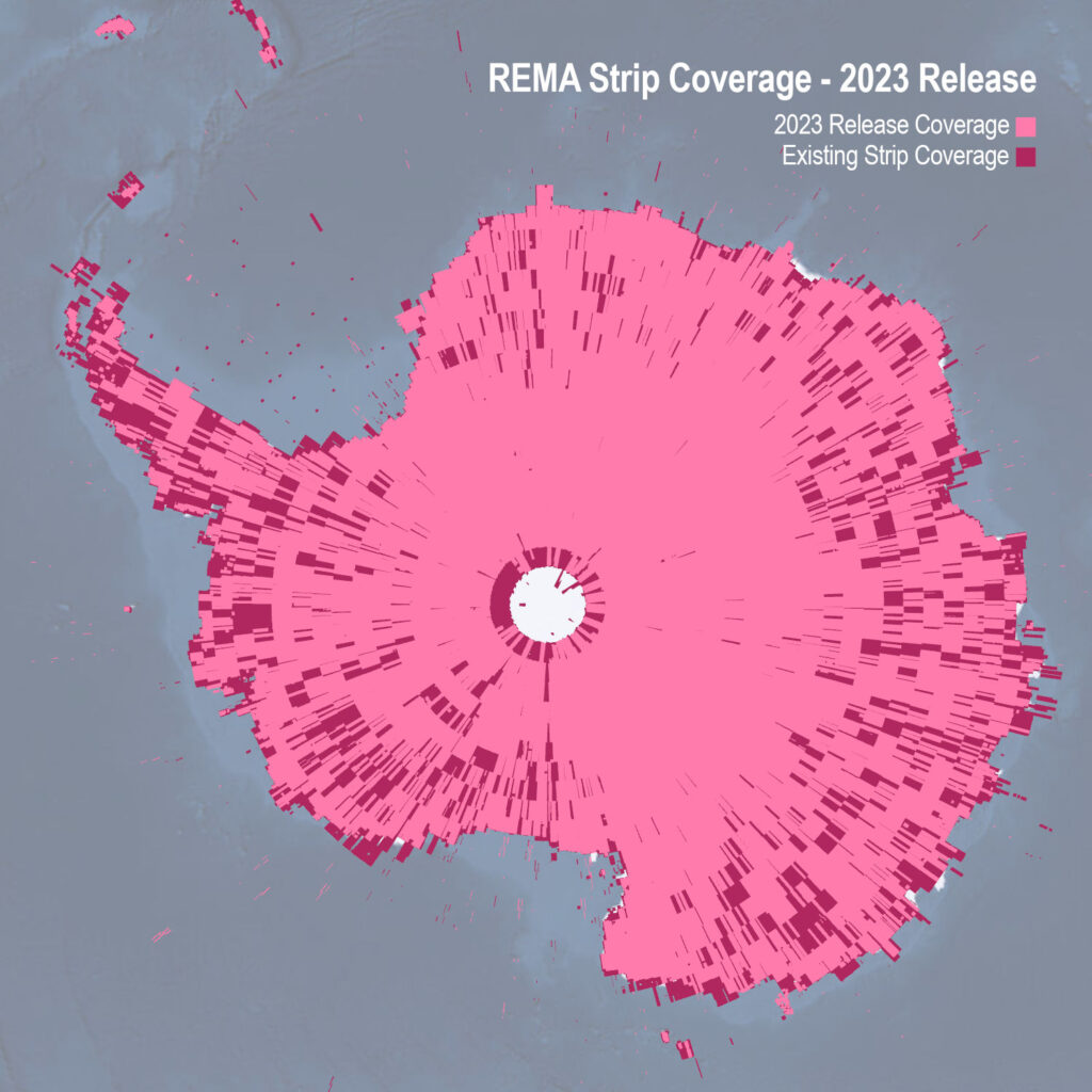
REMA New Strip Coverage (Release June 2024)
STATISTICS
TOTAL STRIPS
51,623
DATES
September 2009 – December 2023
RESTRICTIONS
None
REMA Strips
Strip DEM files correspond to the overlapping area of the input stereoscopic imagery pair strips as they are collected by Maxar’s constellation of polar-orbiting satellites. Strip DEM dimensions will vary according to the satellite sensor that acquired the images and the off-nadir angle of collection. Most strips are between 13 km and 17 km in width, and 110 km and 120 km in length.
Strip DEM files are provided at 2-meter resolution in 32-bit GeoTIFF format. Elevation units are meters and are referenced to the WGS84 ellipsoid. No ground control or altimetry registration has been applied to the strips.
As of July 2023, an exception to EOCL contract allows for continued public access to historical and newly created REMA data. For more information about the current license, check out our EOCL FAQ.
REMA Mosaic
Version 2 Mosaic
Mosaicked DEM files are compiled from the entire stack of strip DEMs as source data. The height value for each pixel in the mosaic is derived from the median value of all contributing strip DEMs, in an effort to extract a consistent surface with low sensitivity to outlying height values. As a result the REMA mosaics include DEMs from austral summer season where the sun elevation is sufficiently high to acquire satellite imagery.
Mosaicked DEM files are distributed at full 2-meter spatial resolution as 50 km x 50 km tiles in 32-bit GeoTIFF format. Reduced resolution versions are also available at 10-meter and 32-meter as 100 km x 100 km tiles, and full-domain 100-meter, 500-meter, and 1-kilometer mosaics. Elevation units are meters and are referenced to the WGS84 ellipsoid.
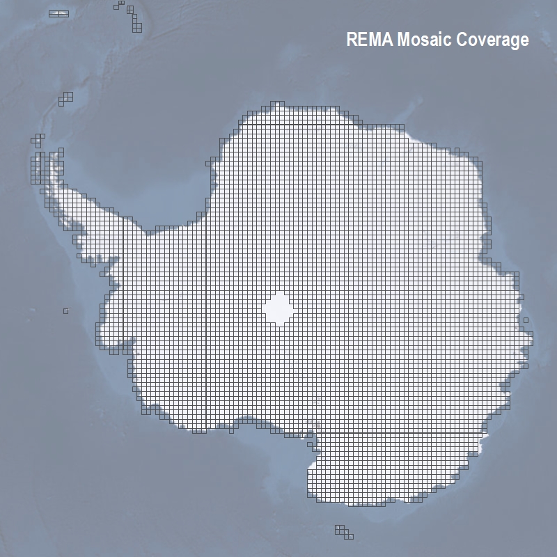
REMA Mosaic Coverage (Release Oct 2022)
Important information regarding the data explorer applications:
DEMs provided by PGC are relative to the WGS84 ellipsoid, whereas the Esri services have transformed those values to be in geoidal/orthometric heights, also referred as Mean Sea Level (EGM08).
There is no login required for the following apps. Users with active NSF-OPP funding for Antarctic research can access and request data (including source imagery) from PGC.
Any download or use of REMA data from the app (or otherwise), must adhere to PGC’s Acknowledgement Policy.
PGC Fridge Data Portal
The PGC Fridge data portal is the best way to preview and download the original datasets (ellipsoidal heights) if no GIS or remote sensing software is available. Users can directly download or choose from a list of DEM products including: full-resolution data, hillshades, masks, metadata, and more. Users with active NSF-OPP funding for Antarctic research may access source imagery via Commercial Satellite Imagery login.
PGC STAC Catalog Access
STAC (Spatio Temporal Asset Catalog) is a standard for organizing geospatial data. REMA’s Static STAC Catalog lets you browse the collection and download assets individually. The Dynamic STAC API facilitates programmatic data queries using python, R, etc.
OpenTopography Portal
The OpenTopography Portal platform provides additional tools for visualization and processing, unlike other access points. DEMs of 32m and 10m resolution data products are open to all users while 2m resolution data products are restricted to education and research users. Queries are limited to 2000 sqkm but include Arc ASCII Grid files, GeoTIFFs, and IMGs with a variety of raster visualization options. Datasets are available in the the original datasets (ellipsoidal heights) for delivery.
Esri REMA Explorer
The Esri REMA Explorer is the best way to preview datasets of geoidal/orthometric heights (Mean Sea Level) if no GIS or remote sensing software is available or you simply want to explore the entire dataset quickly. The full-resolution mosaics are presented in this web map to quickly preview and explore the elevation data. With this web map, users can visualize the REMA data, preview the spatial coverage, and download simple exports. This viewer allows maps to be made, distances to be measured and images to be exported. The shaded relief is optimized to enhance the texture of the ice.
Maps
Map Poster
A shaded relief map poster of the REMA dataset with voids filled and the resolution reduced to 500 meters is available as a 44″x36″ map poster. There are two versions, one that contains cartographic elements such as place name labels, graticules, and facilities, and one that is just the shaded relief image. The maps can be downloaded below.
Large-Format Prints
If the above format isn’t large enough for you, a number of high-resolution images have been created to be printed on a large-format plotter for display on a floor or a large wall. The full continent of Antarctica is available as three strips sized at 36″x132″ with a final size of 9’x11′ when fully assembled. The Antarctic Peninsula and the Thwaites/Pine Island Glacier area of West Antarctica are also available.
All files are downloadable with the links below in .jpg format. Please note: file sizes may be up to 50 Mb.
- Antarctica: Strip 1, Strip 2, Strip 3
- Antarctic Peninsula: Strip 1
- Thwaites / Pine Island Glaciers: Strip 1, Strip 2, Strip 3
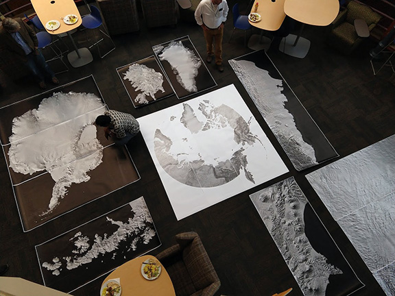
Large-format prints of the Reference Elevation Model of Antarctica. source: Paul Morin, Polar Geospatial Center