Climbing, Hiking & Mountaineering : SummitPost (original) (raw)
Rating the Route (By Hiking Standards)
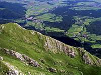 The SW ridge, seen from the W ridge
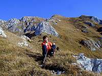
 The ascent by the W-SW ridge is very panoramic
The grading system for hiking and scrambling routes is here.
0. General: From 725 m to 2132 m, exposition south. Below a marked path, on the SW ridge not marked (weak trails, steep grass, some easy rocks). Gear: Good shoes, poles. By the Swiss Scale for hikes the difficulty would be rated T4.
1. Effort: 1410 m, 3 h 30 min,
2. Power: 1 - no difficulties (only walk-up),
3. Psyche: 3 - medium (steep),
4. Orientation: 3 - medium (no real difficulties, but take care for best passages).
Approach
You start the tour on the road above Laško, on a parking place below St. Lovrenc church, some 750 m high. From that parking place the road goes further into the valley and also up, so you can also drive till the small hill of Gradišče (archeologic area) and park there (a small private parking place). From just before the small saddle a path (named "Gamsova pot") goes westwards and then gains the marked path on the ridge. If you drive another 300 meters into the valley, you can park also there (815 m), but there you would need to find the passage towards the NW to reach the marked path. Driving further up is not recommendable (2018), even if the new forrest roads are more and more beaten every year. Thre road deters you away from the S-SW ridge.
Route Description
 On the SW ridge of Storzic The complete situation of the S-SW ascent. On the map left you see both roads, reaching behind the Sv. Lovrenc hill. Blue are the official marked trails. Close-up to see details and read the comments on map elements. Ascent: From the parking place, 750 m, you go either directly up to the church of St. Lovrenc (or via the mountain hut), or - the shortest option - deter from that path soon above the parking place towards the N and follow the marked path which directly reaches the forrested saddle behind St. Lovrenc, 865 m. This saddle can also be reached from the W side. From the saddle, the marked path continues up towards the N. Follow it to the altitude of some 1400 m (a good, although steep marked path) to the crossroads with the path, connecting Javornik alpine meadow with Kališče (hut). On the crossroads you leave marked paths. Just continue directly up, following hunters paths. In the grass you will find signs of tiny paths to the south-west ridge, and when you reach it, you just follow the ridge to the top. The route is very steep, although no climbing is needed. Take care. On the upper part you have to choose the best passages and also scramble over a few rocky sections. One of the rocks is being detoured by the left (W, NW side) and that is the place, which can be tricky if the slopes are already covered with snow or ice. Just below the summit, on a small shoulder, you hit the marked path, coming up through the Javornik ravine (SW ravine). From there just continue on top. On the SW ridge of Storzic The complete situation of the S-SW ascent. On the map left you see both roads, reaching behind the Sv. Lovrenc hill. Blue are the official marked trails. Close-up to see details and read the comments on map elements. Ascent: From the parking place, 750 m, you go either directly up to the church of St. Lovrenc (or via the mountain hut), or - the shortest option - deter from that path soon above the parking place towards the N and follow the marked path which directly reaches the forrested saddle behind St. Lovrenc, 865 m. This saddle can also be reached from the W side. From the saddle, the marked path continues up towards the N. Follow it to the altitude of some 1400 m (a good, although steep marked path) to the crossroads with the path, connecting Javornik alpine meadow with Kališče (hut). On the crossroads you leave marked paths. Just continue directly up, following hunters paths. In the grass you will find signs of tiny paths to the south-west ridge, and when you reach it, you just follow the ridge to the top. The route is very steep, although no climbing is needed. Take care. On the upper part you have to choose the best passages and also scramble over a few rocky sections. One of the rocks is being detoured by the left (W, NW side) and that is the place, which can be tricky if the slopes are already covered with snow or ice. Just below the summit, on a small shoulder, you hit the marked path, coming up through the Javornik ravine (SW ravine). From there just continue on top. |
|---|
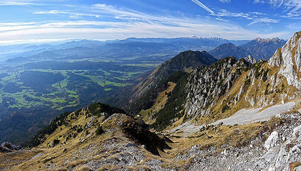
On the S-SW ridge of Storzic
The described route is the most direct route from the south, a normal hiker will need about 3 h, 30 min. (Along this route also a ski descent was done. But it is not the normal ski tour any more - it is on the border between an ordinary ski tour and an alpinistic descent.)
Descent: You best descend by the marked path by the Javornik ravine - to the shepherds hut on planina Javornik (meadow). Then take the crossing path eastwards, towards Kališče and it will bring you on the crossing 1400 m. Then down towards Sv. Lovrenc church.
Hunters Path To Hunters Bivouac
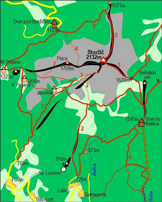
This route can't be recommended. In contrast to the marked route, which gains the crossing marked path on 1400 m, this hunters path goes quite right (east) of it. Actually, I'm still not sure where it starts, but after starting my ascent from the parking place 815 m by a pathless terrain, I kept left (westwards) and hit a good hunters path. It crosses the slopes, on one place it requires quite some care (small steps on exposed grassy terrain), then it finally reaches a distinct grassy valley (or a broad ravine). There the path disappeared and I climbed direcly up by the steep valley. Where it branches, the right passage is the one to be chosen. Above it, after some 300 m of pathless valley ascent you reach the crossing marked path. Just right of that spot is the hunters bivouac in the forrest. So, to continue on Storžič, you'd need to go by the crossing path left - some 200 meters.
PDF Downloads
 - Click to download a suitable A5 printout of this route description in Slovenian language! - Click to download a suitable A5 printout of this route description in English language!