A Tragic Event/A Record Event Tornadoes claimed the lives of 14 Arkansans on the 5th. Two parent storms spawned two tornadoes in a nine county area in northern and central sections of the state. The tornadoes caused extensive damage. This was the deadliest severe weather event in the state since March 1, 1997 when 25 people were killed. It was also an historic event. One of the tornadoes tracked 122 miles, which is the longest track on record in Arkansas since 1950. Longest Tracks in Arkansas Since 1950 When Length February 5, 2008 122 miles (see Note2 below) February 20, 1951 112 miles April 30, 1954 92.4 miles March 20, 1955 89.4 miles December 24, 1982 63 miles Note1: This includes tracks that remained entirely in Arkansas, as well as tracks that entered from or exited into neighboring states. Note2: The track on February 5, 2008 was originally 123 miles. However, the official length (122 miles) was determined by adding starting and ending points of the tornado in each county it crossed. Where the tornado deviated from a straight line (or curved slightly) was omitted. There were ten additional tornadoes counted elsewhere in the state (a total of twelve tornadoes). These tornadoes were generally weak (rated EF0/EF1). Links of Interest Stories About This Event (A Reflection) Coordinate Files of Tornado Tracks: KMZ Note: This file is for use with GIS software. The "KMZ" (compressed "KML") file is intended for applications such as Google Earth. What Happened Early on the 5th, a strong storm system approached from the Plains. Ahead of the system, breezy southerly winds provided well above normal temperatures (record high readings in some areas) and abundant moisture from the Gulf of Mexico. Warmth and moisture destabilized the atmosphere and fueled developing thunderstorms. High Temperatures Site Feb 4th Feb 5th Fayetteville (NW AR) 76°(R) 69° Harrison (NC AR) 76° 72° Jonesboro (NE AR) 74° 73°(R) Fort Smith (WC AR) 79°(R) 75° Little Rock (C AR) 78°(R) 75°(R) North Little Rock (C AR) 76°(R) 74°(R) West Memphis (EC AR) E75°(R) E77°(R) Texarkana (SW AR) 78°(R) 75° El Dorado (SC AR) 76°(R) 77°(R) Monticello (SE AR) 73°(R) 75°(R) R - Record high temperature was tied or broken. E - Estimated high temperature.  Storms began popping up from northeast Oklahoma into southwest Missouri and extreme northwest Arkansas during the morning of the 5th. Winds aloft picked up markedly...which created a lot of lift. Unstable air was drawn quickly upward...leading to the precipitation. In the picture: The pattern at 6 am CST on 02/05/2008...with an interaction between the Polar and Subtropical Jets (wind speeds are in knots) creating a lot of lift in northern and western Arkansas. Thunderstorms become likely, with areas of heavy rain. By afternoon, the system in the Plains dragged a cold front into the state. Thunderstorms became more numerous, with severe weather likely (especially between 2 pm and 10 pm CST). Winds turned with height, and caused some storms to rotate. Two killer tornadoes were spawned, with one of them on the ground for 122 miles! Storms began popping up from northeast Oklahoma into southwest Missouri and extreme northwest Arkansas during the morning of the 5th. Winds aloft picked up markedly...which created a lot of lift. Unstable air was drawn quickly upward...leading to the precipitation. In the picture: The pattern at 6 am CST on 02/05/2008...with an interaction between the Polar and Subtropical Jets (wind speeds are in knots) creating a lot of lift in northern and western Arkansas. Thunderstorms become likely, with areas of heavy rain. By afternoon, the system in the Plains dragged a cold front into the state. Thunderstorms became more numerous, with severe weather likely (especially between 2 pm and 10 pm CST). Winds turned with height, and caused some storms to rotate. Two killer tornadoes were spawned, with one of them on the ground for 122 miles!  In the picture: Helicity (representing the potential for rotating winds) was high (over 500 m2/s2) and CAPE (Convective Available Potential Energy...or a measure of instability) was ample enough (over 1000 J/kg) for severe weather during the afternoon and evening of 02/05/2008. In the picture: Helicity (representing the potential for rotating winds) was high (over 500 m2/s2) and CAPE (Convective Available Potential Energy...or a measure of instability) was ample enough (over 1000 J/kg) for severe weather during the afternoon and evening of 02/05/2008.  In the picture: The WSR-88D (Doppler Weather Radar) Storm Relative Velocity Map (SRM) image indicates strong rotation in northern Conway County between Russellville (Pope County) and Clinton (Van Buren County) at 519 pm CST on 02/05/2008. Strong inbound winds (green/blue colors) are adjacent (gate-to-gate) to strong outbound winds (red/yellow/purple colors)...indicating a lot of rotation. In fact, the radar TVS (Tornado Vortex Signature) algorithm detected a tornado...with a red triangle placed at the center of the rotation. This long track tornado caused extensive damage from Atkins (Pope County) to Clinton (Van Buren County), Mountain View (Stone County) and Highland (Sharp County). Link of Interest What is a Storm Relative Velocity Map (SRM)? In the picture: The WSR-88D (Doppler Weather Radar) Storm Relative Velocity Map (SRM) image indicates strong rotation in northern Conway County between Russellville (Pope County) and Clinton (Van Buren County) at 519 pm CST on 02/05/2008. Strong inbound winds (green/blue colors) are adjacent (gate-to-gate) to strong outbound winds (red/yellow/purple colors)...indicating a lot of rotation. In fact, the radar TVS (Tornado Vortex Signature) algorithm detected a tornado...with a red triangle placed at the center of the rotation. This long track tornado caused extensive damage from Atkins (Pope County) to Clinton (Van Buren County), Mountain View (Stone County) and Highland (Sharp County). Link of Interest What is a Storm Relative Velocity Map (SRM)?  Five people were killed near Atkins (Pope County), and there were three deaths in Van Buren County. In the picture: Two deadly tornadic supercells (storms with rotating updrafts) moved across northern Arkansas on 02/05/2008. Storm #1 produced one long track tornado (122 miles). There was one tornado with Storm #2 as well. Fourteen people were killed (5 deaths in Pope County, 3 deaths in Van Buren County, 2 deaths in Conway and Izard Counties and 1 death in Baxter and Stone Counties). The other tornado was spawned farther north from near Rea Valley (Marion County) to Gassville (Baxter County). One death was reported in the Gassvile (Baxter County) area. In all, 14 fatalities were reported. Part of the Super Tuesday Tornado Outbreak While there was a lot going on in Arkansas, it was awful in surrounding states as well. During this event (dubbed the "Super Tuesday Tornado Outbreak"), there were 87 tornadoes and 57 fatalities counted. Tornadoes were deadly in Alabama, Arkansas, Kentucky, and Tennessee. The deadliest tornado (22 fatalities) tracked from Castalian Springs, TN through Tompkinsville, KY. Ten tornadoes were rated EF3/EF4. More Information There is more concerning the storms of February 5th. To check out the rest of the story, click here. To Severe Weather on February 5, 2008 (Page 2 of 2) Back to Historic Events in Arkansas https://www.weather.gov/lzk/svr0208yr.htm Five people were killed near Atkins (Pope County), and there were three deaths in Van Buren County. In the picture: Two deadly tornadic supercells (storms with rotating updrafts) moved across northern Arkansas on 02/05/2008. Storm #1 produced one long track tornado (122 miles). There was one tornado with Storm #2 as well. Fourteen people were killed (5 deaths in Pope County, 3 deaths in Van Buren County, 2 deaths in Conway and Izard Counties and 1 death in Baxter and Stone Counties). The other tornado was spawned farther north from near Rea Valley (Marion County) to Gassville (Baxter County). One death was reported in the Gassvile (Baxter County) area. In all, 14 fatalities were reported. Part of the Super Tuesday Tornado Outbreak While there was a lot going on in Arkansas, it was awful in surrounding states as well. During this event (dubbed the "Super Tuesday Tornado Outbreak"), there were 87 tornadoes and 57 fatalities counted. Tornadoes were deadly in Alabama, Arkansas, Kentucky, and Tennessee. The deadliest tornado (22 fatalities) tracked from Castalian Springs, TN through Tompkinsville, KY. Ten tornadoes were rated EF3/EF4. More Information There is more concerning the storms of February 5th. To check out the rest of the story, click here. To Severe Weather on February 5, 2008 (Page 2 of 2) Back to Historic Events in Arkansas https://www.weather.gov/lzk/svr0208yr.htm |


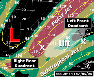
 Storms began popping up from northeast Oklahoma into southwest Missouri and extreme northwest Arkansas during the morning of the 5th. Winds aloft picked up markedly...which created a lot of lift. Unstable air was drawn quickly upward...leading to the precipitation. In the picture: The pattern at 6 am CST on 02/05/2008...with an interaction between the Polar and Subtropical Jets (wind speeds are in knots) creating a lot of lift in northern and western Arkansas. Thunderstorms become likely, with areas of heavy rain. By afternoon, the system in the Plains dragged a cold front into the state. Thunderstorms became more numerous, with severe weather likely (especially between 2 pm and 10 pm CST). Winds turned with height, and caused some storms to rotate. Two killer tornadoes were spawned, with one of them on the ground for 122 miles!
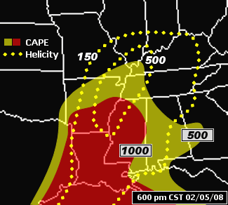
  In the picture: Helicity (representing the potential for rotating winds) was high (over 500 m2/s2) and CAPE (Convective Available Potential Energy...or a measure of instability) was ample enough (over 1000 J/kg) for severe weather during the afternoon and evening of 02/05/2008.
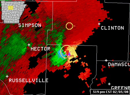
  In the picture: The WSR-88D (Doppler Weather Radar) Storm Relative Velocity Map (SRM) image indicates strong rotation in northern Conway County between Russellville (Pope County) and Clinton (Van Buren County) at 519 pm CST on 02/05/2008. Strong inbound winds (green/blue colors) are adjacent (gate-to-gate) to strong outbound winds (red/yellow/purple colors)...indicating a lot of rotation. In fact, the radar TVS (Tornado Vortex Signature) algorithm detected a tornado...with a red triangle placed at the center of the rotation. This long track tornado caused extensive damage from Atkins (Pope County) to Clinton (Van Buren County), Mountain View (Stone County) and Highland (Sharp County). Link of Interest What is a Storm Relative Velocity Map (SRM)?
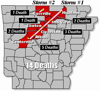
  Five people were killed near Atkins (Pope County), and there were three deaths in Van Buren County. In the picture: Two deadly tornadic supercells (storms with rotating updrafts) moved across northern Arkansas on 02/05/2008. Storm #1 produced one long track tornado (122 miles). There was one tornado with Storm #2 as well. Fourteen people were killed (5 deaths in Pope County, 3 deaths in Van Buren County, 2 deaths in Conway and Izard Counties and 1 death in Baxter and Stone Counties). The other tornado was spawned farther north from near Rea Valley (Marion County) to Gassville (Baxter County). One death was reported in the Gassvile (Baxter County) area. In all, 14 fatalities were reported. Part of the Super Tuesday Tornado Outbreak While there was a lot going on in Arkansas, it was awful in surrounding states as well. During this event (dubbed the "Super Tuesday Tornado Outbreak"), there were 87 tornadoes and 57 fatalities counted. Tornadoes were deadly in Alabama, Arkansas, Kentucky, and Tennessee. The deadliest tornado (22 fatalities) tracked from Castalian Springs, TN through Tompkinsville, KY. Ten tornadoes were rated EF3/EF4. More Information There is more concerning the storms of February 5th. To check out the rest of the story, click here. To Severe Weather on February 5, 2008 (Page 2 of 2) Back to Historic Events in Arkansas https://www.weather.gov/lzk/svr0208yr.htm