 |
|
|
| (Information by Peter Kessler, with additional information from The Philistines and Other 'Sea Peoples' in Text and Archaeology, Ann E Killebrew (Society of Biblical Literature Archaeology and Biblical Studies, 2013), from The Histories, Herodotus (Penguin, 1996), from The Iliad, Homer (Translated by E V Rieu, Penguin Books, 1963), from The Kingdom of the Hittites, Trevor Bryce (1998), from The Hittites, O R Gurney (1991), from Trojans and Their Neighbours: An Introduction (Ancient Peoples), Trevor Bryce (2005), from the Argonautica, Apollonius Rhodius (3rd century BC Greek epic poem), and from External Links: the Dictionary of Greek and Roman Geography, William Smith (Ed, 1854), and DNA clue to origins of early Greek civilisation (BBC News), and Geography, Strabo (H C Hamilton & W Falconer, London, 1903, Perseus Online Edition), and The Greeks really do have near-mythical origins, ancient DNA reveals (Science).) |
|
|
| c.1230s BC |
Stheneleus |
Ruler of Kolonae. |
| c.1230s - 1183 BC |
Cygnus / Kyknos / Cycnus |
Son. m Prokleia, a daughter of Laomedon of Troy. |
| c.1193 - 1183 BC |
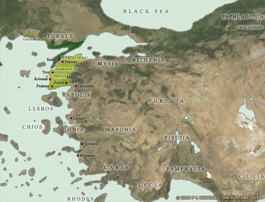
Cygnus (whom some sources acquaint with the historical Kikunni of Troy in the fourteenth century BC) leads the Kolonaean contingent to the Trojan War on the side of Troy. Whilst being invulnerable to weapons thanks to Poseidon, Cygnus is still killed by Achilles of Phthia (on the first day of the main conflict, as noted by the now-lost Cypria, after which he is transformed into a swan by Poseidon).  Troy's various regional allies at the time of the Trojan War are shown here, many of which are only mentioned in later works by Homer, Herodotus, and other Greek chroniclers (click or tap on map to view full sized) Troy's various regional allies at the time of the Trojan War are shown here, many of which are only mentioned in later works by Homer, Herodotus, and other Greek chroniclers (click or tap on map to view full sized) |
|
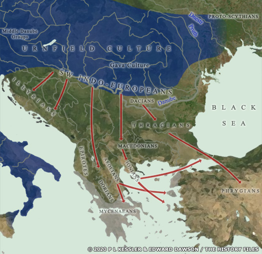
Increasing drought in the Near East has already resulted in famine and the subsequent movement of peoples who are in search of new food supplies. Collectively known by chroniclers as the Sea Peoples, various groups are raiding the Mediterranean coastline, attacking kingdoms and destroying cities and, in some cases, even settling in the conquered areas. The Trojan War feeds into this ongoing chain of calamity and destruction. With Trojan refugees fleeing in all directions, and even the victorious Mycenaeans being pushed out of their territory by migrating Dorians, both peoples probably add to the pressure on the states of the eastern Mediterranean. The age of the migratory Sea Peoples can only be said to be over by around 1100 BC, as the turmoil and chaos (such as during Egypt's 'Third Intermediate Period' or in [ Syria](SyriaCityStates.htm#Greater Syrian States)) gives way to an already-active dark age and a gradual rebuilding of civilisation.  Climate-induced drought in the thirteenth century BC created great instability in the entire eastern Mediterranean region, resulting in mass migration in the Balkans, as well as the fall of city states and kingdoms further east (click or tap on map to view full sized) Climate-induced drought in the thirteenth century BC created great instability in the entire eastern Mediterranean region, resulting in mass migration in the Balkans, as well as the fall of city states and kingdoms further east (click or tap on map to view full sized) |
|
|
| During this period, Anatolia's coastline largely becomes a possession of various Greek states and cities. Kolonae itself may be abandoned for a while during this period. The first Greek ceramic materials appear in the seventh century BC, possibly as a result of colonisation from Mytilene, after which it becomes one of hundreds of Greek cities in Anatolia. |
|
|
 |
|
|
 Mysia was also part of the region while the principle city in this part of Anatolia, Troy, was nearby, and Dardania could also be included within the Troad, along with its native population of Teucri. Wilusa in the thirteenth century was a member of the Assuwa (or Assua), a confederacy of local minor states which probably included the states of the Troad and which had traditionally been allied to the Hittites (see feature link). The city of Kolonae (otherwise Kolonai or Colonae) was included within the Troad. The city of Kolonae (using either a hard 'k' or a hard 'c') was located one hundred and forty stadia to the south of Ilium (Troy, with one stadion equalling 6.3411540900444 kilometres, giving 22.078 kilometres). More locating by modern scholars has it on a hill by the coast which is known in modern Turkey as Beşiktepe (meaning 'cradle hill'). This lies roughly equidistant between Pedasus to the south and Troy to the north. Along with the rest of the region it was a Trojan ally during the war against the Mycenaeans. The name probably stems from 'col' or 'calach' for an eminence, with the term generally being used in Anatolia to denote a fortress. That name survived the subsequent dark age, although native settlement may not have. Evidence shows Greek colonisation beginning in the seventh century BC, possibly by settlers from Mytilene.
 Troy's various regional allies at the time of the Trojan War are shown here, many of which are only mentioned in later works by Homer, Herodotus, and other Greek chroniclers (click or tap on map to view full sized)
 Climate-induced drought in the thirteenth century BC created great instability in the entire eastern Mediterranean region, resulting in mass migration in the Balkans, as well as the fall of city states and kingdoms further east (click or tap on map to view full sized)