Antegnate (original) (raw)
From Wikipedia, the free encyclopedia
Comune in Lombardy, Italy
| Antegnate | |
|---|---|
| Comune | |
| Comune di Antegnate | |
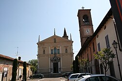
 Church of San Michele Arcangelo Church of San Michele Arcangelo |
|
 Coat of arms Coat of arms |
|
Location of Antegnate  |
|
  AntegnateLocation of Antegnate in ItalyShow map of Italy AntegnateLocation of Antegnate in ItalyShow map of Italy  AntegnateAntegnate (Lombardy)Show map of Lombardy AntegnateAntegnate (Lombardy)Show map of Lombardy |
|
| Coordinates: 45°29′N 9°47′E / 45.483°N 9.783°E / 45.483; 9.783 | |
| Country | Italy |
| Region | Lombardy |
| Province | Bergamo (BG) |
| Government | |
| • Mayor | Andrea Maria Lanzini (lista civica) |
| Area[1] | |
| • Total | 9.73 km2 (3.76 sq mi) |
| Elevation | 112 m (367 ft) |
| Population (28 February 2017)[2] | |
| • Total | 3,216 |
| • Density | 330/km2 (860/sq mi) |
| Demonym | Antegnatesi |
| Time zone | UTC+1 (CET) |
| • Summer (DST) | UTC+2 (CEST) |
| Postal code | 24051 |
| Dialing code | 0363 |
| Patron saint | Saint Michael the Archangel |
| Saint day | 29 September |
| Website | Official website |
Antegnate (Bergamasque: Antegnàt) is a comune (municipality) in the Province of Bergamo in the Italian region of Lombardy, located about 50 kilometres (31 mi) east of Milan and about 25 kilometres (16 mi) southeast of Bergamo.
Antegnate borders the following municipalities: Barbata, Calcio, Covo, Fontanella.
- ^ "Superficie di Comuni Province e Regioni italiane al 9 ottobre 2011". Italian National Institute of Statistics. Retrieved 16 March 2019.
- ^ All demographics and other statistics: Italian statistical institute Istat.