List of places of worship in Brussels (original) (raw)
From Wikipedia, the free encyclopedia
In Brussels, there are numerous church buildings, most of which are attached to the Roman Catholic Church. The Brussels-Capital Region is home to 107 Catholic parishes. Other religious buildings in the region are also mentioned.
| name | district | coordinates | denomination | photo |
|---|---|---|---|---|
| Our Lady Of Caucasian Dell Church | Auderghem/Oudergem | 50°48′23.38″N 4°26′15.27″E / 50.8064944°N 4.4375750°E / 50.8064944; 4.4375750 | Roman Catholic | |
| St. Anne's Church, Auderghem | Auderghem/Oudergem | 50°48′57.25″N 4°26′1.41″E / 50.8159028°N 4.4337250°E / 50.8159028; 4.4337250 | Roman Catholic |  |
| St. Julien Church | Auderghem/Oudergem | 50°49′16.3″N 4°24′34.77″E / 50.821194°N 4.4096583°E / 50.821194; 4.4096583 | Roman Catholic |
Berchem-Sainte-Agathe/Sint-Agatha-Berchem
[edit]
| name | district | coordinates | denomination | photo |
|---|---|---|---|---|
| Old St. Agatha Church, Sint-Agatha-Berchem | Berchem-Sainte-Agathe/Sint-Agatha-Berchem | 50°51′48.92″N 4°17′42.97″E / 50.8635889°N 4.2952694°E / 50.8635889; 4.2952694 | Roman Catholic |  |
| name | district | coordinates | denomination | photo |
|---|---|---|---|---|
| Church of Our Lady of the Sacred Heart, Etterbeek | Etterbeek | 50°49′53.52″N 4°24′1.08″E / 50.8315333°N 4.4003000°E / 50.8315333; 4.4003000 | Roman Catholic | |
| Church of St. John Berchmans[9] | Etterbeek | 50°50′5″N 4°24′26″E / 50.83472°N 4.40722°E / 50.83472; 4.40722 | Roman Catholic |  |
| Our Lady Immaculate Church, Etterbeek | Etterbeek | 50°50′3.3″N 4°22′51.77″E / 50.834250°N 4.3810472°E / 50.834250; 4.3810472 | Roman Catholic | |
| St. Anthony of Padua Church, Brussels | Etterbeek | 50°50′36.41″N 4°20′34.31″E / 50.8434472°N 4.3428639°E / 50.8434472; 4.3428639 | Roman Catholic |  |
| St. Gertrude Church, Etterbeek | Etterbeek | 50°50′11.45″N 4°23′24.45″E / 50.8365139°N 4.3901250°E / 50.8365139; 4.3901250 | Roman Catholic |
| name | district | coordinates | denomination | photo |
|---|---|---|---|---|
| Church of Our Lady Immaculate Received, Evere | Evere | 50°52′15.43″N 4°24′2.33″E / 50.8709528°N 4.4006472°E / 50.8709528; 4.4006472 | Roman Catholic |  |
| Saint Joseph Church, Evere | Evere | 50°51′31.58″N 4°24′53.43″E / 50.8587722°N 4.4148417°E / 50.8587722; 4.4148417 | Roman Catholic |  |
| St. Vincent Church | Evere | 50°52′52.78″N 4°24′11.28″E / 50.8813278°N 4.4031333°E / 50.8813278; 4.4031333 | Roman Catholic |  |
| name | district | coordinates | denomination | photo |
|---|---|---|---|---|
| Holy Mary Mother of God Church | Forest/Vorst | 50°49′12.66″N 4°19′44.65″E / 50.8201833°N 4.3290694°E / 50.8201833; 4.3290694 | Roman Catholic | |
| Holy Father Van Ars Church | Forest/Vorst | 50°48′21.37″N 4°19′14.41″E / 50.8059361°N 4.3206694°E / 50.8059361; 4.3206694 | Roman Catholic | |
| Saint Pius X Church | Forest/Vorst | 50°48′29.82″N 4°19′57.77″E / 50.8082833°N 4.3327139°E / 50.8082833; 4.3327139 | Roman Catholic | |
| St. Anthony of Padua Church | Forest/Vorst | 50°49′40.29″N 4°19′54.13″E / 50.8278583°N 4.3317028°E / 50.8278583; 4.3317028 | Roman Catholic | |
| Church of St. Augustine[10] | Altitude Cent/Hoogte Honderd, Forest/Vorst | 50°48′59.96″N 4°20′12.33″E / 50.8166556°N 4.3367583°E / 50.8166556; 4.3367583 | Roman Catholic |  |
| Barnabites Church | Forest/Vorst | 50°49′7.18″N 4°21′2.76″E / 50.8186611°N 4.3507667°E / 50.8186611; 4.3507667 | Roman Catholic |  |
| Saint-Denis Church, Vorst | Forest/Vorst | 50°48′40.11″N 4°19′3.84″E / 50.8111417°N 4.3177333°E / 50.8111417; 4.3177333 | Roman Catholic |  |
| name | district | coordinates | denomination | photo |
|---|---|---|---|---|
| St. Cecilia's Church | Ganshoren | 50°52′28.43″N 4°18′12.45″E / 50.8745639°N 4.3034583°E / 50.8745639; 4.3034583 | Roman Catholic | |
| Saint Martin's Church | Ganshoren | 50°52′19.83″N 4°18′52.81″E / 50.8721750°N 4.3146694°E / 50.8721750; 4.3146694 | Roman Catholic |
| name | district | coordinates | denomination | photo |
|---|---|---|---|---|
| Saint Elisabeth Church, Haren | Haren | 50°53′34.1″N 4°25′2.87″E / 50.892806°N 4.4174639°E / 50.892806; 4.4174639 | Roman Catholic |  |
| name | district | coordinates | denomination | photo |
|---|---|---|---|---|
| St. Clara Church, Jette | Jette | 50°53′32.19″N 4°19′21.38″E / 50.8922750°N 4.3226056°E / 50.8922750; 4.3226056 | Roman Catholic | |
| Saint Joseph Church, Jette | Dielegem, Jette | 50°53′11.58″N 4°19′9.35″E / 50.8865500°N 4.3192639°E / 50.8865500; 4.3192639 | Roman Catholic | |
| Our Lady of Lourdes Church, Jette | Jette | 50°52′23.8″N 4°20′7.26″E / 50.873278°N 4.3353500°E / 50.873278; 4.3353500 | Roman Catholic | |
| St. Peters Church, Jette | Jette | 50°52′49.37″N 4°19′49.92″E / 50.8803806°N 4.3305333°E / 50.8803806; 4.3305333 | Roman Catholic |  |
| name | district | coordinates | denomination | photo |
|---|---|---|---|---|
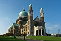
| Basilica of the Sacred Heart[11] | Koekelberg | 50°52′1″N 4°19′1″E / 50.86694°N 4.31694°E / 50.86694; 4.31694 | Roman Catholic |  |
| St. Anna Church, Koekelberg | Koekelberg | 50°51′37.36″N 4°19′55.25″E / 50.8603778°N 4.3320139°E / 50.8603778; 4.3320139 | Roman Catholic |
| name | district | coordinates | denomination | photo |
|---|---|---|---|---|
| Christ the King Church, Laken | Mutsaard, Laeken/Laken | 50°53′56.54″N 4°21′48.61″E / 50.8990389°N 4.3635028°E / 50.8990389; 4.3635028 | Roman Catholic | |
| Saint Lambert Church, Laken | Heysel/Heizel, Laeken/Laken | 50°53′26.6″N 4°20′38.13″E / 50.890722°N 4.3439250°E / 50.890722; 4.3439250 | Roman Catholic | |
| Holy Angels Church | Laeken/Laken | 50°52′55.04″N 4°20′26.59″E / 50.8819556°N 4.3407194°E / 50.8819556; 4.3407194 | Roman Catholic | |
| Church of Our Lady of Laeken[12] | Laeken/Laken | 50°52′43″N 4°21′21″E / 50.87861°N 4.35583°E / 50.87861; 4.35583 | Roman Catholic |  |
| Divine Child Jesus Church, Laken | Verregat, Laeken/Laken | 50°53′50.62″N 4°19′42″E / 50.8973944°N 4.32833°E / 50.8973944; 4.32833 | Roman Catholic |
Molenbeek-Saint-Jean/Sint-Jans-Molenbeek
[edit]
Neder-Over-Heembeek
[edit]
| name | district | coordinates | denomination | photo |
|---|---|---|---|---|
| New St. Peter and Paul Church | Neder-Over-Heembeek | 50°53′45.97″N 4°23′16.85″E / 50.8961028°N 4.3880139°E / 50.8961028; 4.3880139 | Roman Catholic |
Saint Gilles/Saint-Gillis
[edit]
| name | district | coordinates | denomination | photo |
|---|---|---|---|---|
| Jesus Worker Church | Saint Gilles/Sint-Gillis | 50°49′35.15″N 4°20′16.4″E / 50.8264306°N 4.337889°E / 50.8264306; 4.337889 | Roman Catholic | |
| St. Alena Church | Saint Gilles/Sint-Gillis | 50°49′28.39″N 4°20′27.08″E / 50.8245528°N 4.3408556°E / 50.8245528; 4.3408556 | Roman Catholic |  |
| St. Bernard Church, Saint-Gillis | Saint Gilles/Sint-Gillis | 50°49′50.18″N 4°21′14.27″E / 50.8306056°N 4.3539639°E / 50.8306056; 4.3539639 | Roman Catholic | |
| St Giles' Church, Saint-Gillis | Saint Gilles/Sint-Gillis | 50°49′50.19″N 4°20′37.47″E / 50.8306083°N 4.3437417°E / 50.8306083; 4.3437417 | Roman Catholic |
Saint-Josse-ten-Node/Sint-Joost-ten-Node
[edit]
| name | district | coordinates | denomination | photo |
|---|---|---|---|---|
| Saint-Josse Church | Saint-Josse-ten-Node/Sint-Joost-ten-Node | 50°51′0.58″N 4°22′28.26″E / 50.8501611°N 4.3745167°E / 50.8501611; 4.3745167 | Roman Catholic |  |
Schaerbeek/Schaarbeek
[edit]
Watermael-Boitsfort/Watermaal-Bosvoorde
[edit]
| name | district | coordinates | denomination | photo |
|---|---|---|---|---|
| Our Lady of Perpetual Help Church | Watermael-Boitsfort/Watermaal-Bosvoorde | 50°48′30.97″N 4°25′3.97″E / 50.8086028°N 4.4177694°E / 50.8086028; 4.4177694 | Roman Catholic | |
| Church of St. Clement | Watermael-Boitsfort/Watermaal-Bosvoorde | 50°48′35.93″N 4°24′20.96″E / 50.8099806°N 4.4058222°E / 50.8099806; 4.4058222 | Roman Catholic |  |
| Holy Cross Church, Watermael-Boitsfort | Watermael-Boitsfort/Watermaal-Bosvoorde | 50°48′1.03″N 4°23′57.62″E / 50.8002861°N 4.3993389°E / 50.8002861; 4.3993389 | Roman Catholic | |
| Queen of Heaven Church | Watermael-Boitsfort/Watermaal-Bosvoorde | 50°47′24.02″N 4°25′18.71″E / 50.7900056°N 4.4218639°E / 50.7900056; 4.4218639 | Roman Catholic | |
| St. Hubert Church, Watermael | Watermael-Boitsfort/Watermaal-Bosvoorde | 50°47′46.8″N 4°24′50.44″E / 50.796333°N 4.4140111°E / 50.796333; 4.4140111 | Roman Catholic |  |
Woluwe-Saint-Lambert/Sint-Lambrechts-Woluwe
[edit]
| name | district | coordinates | denomination | photo |
|---|---|---|---|---|
| Our Lady Assumption Church, Woluwe-Saint-Lambert | Kapelleveld, Woluwe-Saint-Lambert/Sint-Lambrechts-Woluwe | 50°50′52.91″N 4°27′4.08″E / 50.8480306°N 4.4511333°E / 50.8480306; 4.4511333 | Roman Catholic | |
| Chapel of Lenneke | Woluwe-Saint-Lambert/Sint-Lambrechts-Woluwe | 50°50′46″N 4°26′31.99″E / 50.84611°N 4.4422194°E / 50.84611; 4.4422194 | Roman Catholic |  |
| Holy-Family Church, Woluwe-Saint-Lambert | Woluwe-Saint-Lambert/Sint-Lambrechts-Woluwe | 50°51′0.51″N 4°25′38.58″E / 50.8501417°N 4.4273833°E / 50.8501417; 4.4273833 | Roman Catholic | |
| St. Henricus Church | Woluwe-Saint-Lambert/Sint-Lambrechts-Woluwe | 50°50′31.37″N 4°24′35.7″E / 50.8420472°N 4.409917°E / 50.8420472; 4.409917 | Roman Catholic | |
| Saint Lambert Church | Woluwe-Saint-Lambert/Sint-Lambrechts-Woluwe | 50°50′29.04″N 4°25′59.13″E / 50.8414000°N 4.4330917°E / 50.8414000; 4.4330917 | Roman Catholic |  |
Woluwe-Saint-Pierre/Sint-Pieters-Woluwe
[edit]
| name | district | coordinates | denomination | photo |
|---|---|---|---|---|
| St. Paul's Church, Woluwe-Saint-Pierre | Woluwe-Saint-Pierre/Sint-Pieters-Woluwe | 50°49′47.76″N 4°26′51.08″E / 50.8299333°N 4.4475222°E / 50.8299333; 4.4475222 | Roman Catholic | |
| St. Peters Church, Woluwe-Saint-Pierre | Woluwe-Saint-Pierre/Sint-Pieters-Woluwe | 50°50′17.78″N 4°25′54.26″E / 50.8382722°N 4.4317389°E / 50.8382722; 4.4317389 | Roman Catholic | |
| Church of Our Lady, Stokkel | Woluwe-Saint-Pierre/Sint-Pieters-Woluwe | 50°50′28.61″N 4°27′46″E / 50.8412806°N 4.46278°E / 50.8412806; 4.46278 | Roman Catholic | |
| St. Aleydis Church, Woluwe-Saint-Pierre | Woluwe-Saint-Pierre/Sint-Pieters-Woluwe | 50°49′41.38″N 4°27′44.32″E / 50.8281611°N 4.4623111°E / 50.8281611; 4.4623111 | Roman Catholic | |
| Our Lady of Grace Church | Woluwe-Saint-Pierre/Sint-Pieters-Woluwe | 50°49′37.38″N 4°25′7.43″E / 50.8270500°N 4.4187306°E / 50.8270500; 4.4187306 | Roman Catholic |
- ^ "Collégiale Saints-Pierre-et-Guidon – Inventaire du patrimoine architectural". monument.heritage.brussels (in French). Retrieved 2024-03-21.
- ^ "Eglise Notre-Dame des Victoires au Sablon – Inventaire du patrimoine architectural". monument.heritage.brussels (in French). Retrieved 2024-03-21.
- ^ "Eglise paroissale Notre-Dame de la Chapelle – Inventaire du patrimoine architectural". monument.heritage.brussels (in French). Retrieved 2024-03-21.
- ^ "église paroissiale Sainte-Catherine – Inventaire du patrimoine architectural". monument.heritage.brussels (in French). Retrieved 2024-03-21.
- ^ "Eglise Saint-Jean-Baptiste au Béguinage – Inventaire du patrimoine architectural". monument.heritage.brussels (in French). Retrieved 2024-03-21.
- ^ "Eglise Saint-Jacques-sur-Coudenberg – Inventaire du patrimoine architectural". monument.heritage.brussels (in French). Retrieved 2024-03-21.
- ^ "Cathédrale Saints-Michel-et-Gudule – Inventaire du patrimoine architectural". monument.heritage.brussels (in French). Retrieved 2024-03-21.
- ^ "Grande Mosquée et Centre islamique et culturel de Belgique – ancien Pavillon du Panorama du Caire – Inventaire du patrimoine architectural". monument.heritage.brussels (in French). Retrieved 2024-03-21.
- ^ "Collège Saint-Michel – Inventaire du patrimoine architectural". monument.heritage.brussels (in French). Retrieved 2024-03-21.
- ^ "Eglise Saint-Augustin – Inventaire du patrimoine architectural". monument.heritage.brussels (in French). Retrieved 2024-03-21.
- ^ "Basilique Nationale du Sacré-Cœur – Inventaire du patrimoine architectural". monument.heritage.brussels (in French). Retrieved 2024-03-21.
- ^ "Église Notre-Dame de Laeken – Inventaire du patrimoine architectural". monument.heritage.brussels (in French). Retrieved 2024-03-21.
- ^ "église Saint-Jean-Baptiste – Inventaire du patrimoine architectural". monument.heritage.brussels (in French). Retrieved 2024-03-21.
- ^ "Église Sainte-Marie – Inventaire du patrimoine architectural". monument.heritage.brussels (in French). Retrieved 2024-03-21.


