population, maps, real estate, averages, homes, statistics, relocation, travel, jobs, hospitals, schools, crime, moving, houses, news, sex offenders (original) (raw)
Wheatland, Iowa
Submit your own pictures of this city and show them to the world
OSM Map
General Map
Google Map
MSN Map
OSM Map
General Map
Google Map
MSN Map
OSM Map
General Map
Google Map
MSN Map
OSM Map
General Map
Google Map
MSN Map
Please wait while loading the map...
Population in 2022: 771 (0% urban, 100% rural).
Population change since 2000: -0.1%
| Median resident age: | 30.0 years |
|---|---|
| Iowa median age: | 38.9 years |
Zip codes: 52777.
Estimated median household income in 2022: 33,665(∗∗itwas∗∗33,665 (it was 33,665(∗∗itwas∗∗30,875 in 2000)
| Wheatland: | $33,665 |
|---|---|
| IA: | $69,588 |
Estimated per capita income in 2022: 21,284(∗∗itwas∗∗21,284 (it was 21,284(∗∗itwas∗∗13,824 in 2000)
Wheatland city income, earnings, and wages data
Estimated median house or condo value in 2022: 104,908(∗∗itwas∗∗104,908 (it was 104,908(∗∗itwas∗∗65,800 in 2000)
| Wheatland: | $104,908 |
|---|---|
| IA: | $194,600 |
Mean prices in 2022: all housing units: 122,751;∗∗detachedhouses:∗∗122,751; detached houses: 122,751;∗∗detachedhouses:∗∗124,178; townhouses or other attached units: 124,634;∗∗mobilehomes:∗∗124,634; mobile homes: 124,634;∗∗mobilehomes:∗∗58,049
Median gross rent in 2022: $724.
March 2022 cost of living index in Wheatland: 82.9 (low, U.S. average is 100)
Wheatland, IA residents, houses, and apartments details
Percentage of residents living in poverty in 2022: 6.6%
Detailed information about poverty and poor residents in Wheatland, IA
Business Search - 14 Million verified businesses
- 79090.9%White alone
- 445.1%Hispanic
- 222.5%Two or more races
- 60.7%Black alone
- 20.2%Other race alone
Races in Wheatland detailed stats: ancestries, foreign born residents, place of birth

Latest news from Wheatland, IA collected exclusively by city-data.com from local newspapers, TV, and radio stations
Ancestries: German (47.1%), American (15.2%), Irish (2.9%), Italian (2.2%), Polish (1.8%), Brazilian (1.4%).
Current Local Time: CST time zone
Incorporated on 07/13/1869
Elevation: 700 feet
Land area: 0.56 square miles.
Population density: 1,388 people per square mile (low).
7 residents are foreign born
Median real estate property taxes paid for housing units with mortgages in 2022: $1,348 (1.3%)
Median real estate property taxes paid for housing units with no mortgage in 2022: $1,674 (1.4%)
Nearest city with pop. 50,000+: Davenport, IA (23.8 miles , pop. 98,359).
Nearest city with pop. 200,000+: Madison, WI (113.2 miles , pop. 208,054).
Nearest city with pop. 1,000,000+: Chicago, IL (162.8 miles , pop. 2,896,016).
Nearest cities:
Toronto, IA (2.2 miles),
New Liberty, IA (2.9 miles),
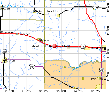
Latitude: 41.83 N**, Longitude:** 90.84 W
Area code: 563
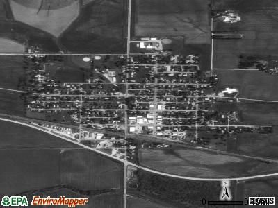
Single-family new house construction building permits:
- 2018: 2 buildings , average cost: $208,900
- 2017: 2 buildings , average cost: $208,900
- 2016: 2 buildings , average cost: $208,900
Unemployment in December 2023:
Population change in the 1990s: +44 (+6.0%).
Most common industries in Wheatland, IA (%)
- Health care (9.7%)
- Educational services (9.0%)
- Accommodation & food services (8.7%)
- Metal & metal products (8.1%)
- Truck transportation (5.5%)
- Construction (5.5%)
- Gasoline stations (4.5%)
Most common occupations in Wheatland, IA (%)
- Laborers and material movers, hand (8.1%)
- Driver/sales workers and truck drivers (6.1%)
- Preschool, kindergarten, elementary, and middle school teachers (5.2%)
- Other sales and related occupations, including supervisors (5.2%)
- Electrical equipment mechanics and other installation, maintenance, and repair workers, including supervisors (4.8%)
- Material recording, scheduling, dispatching, and distributing workers (4.5%)
- Other production occupations, including supervisors (4.2%)
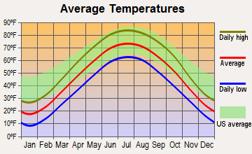
Average climate in Wheatland, Iowa
Based on data reported by over 4,000 weather stations
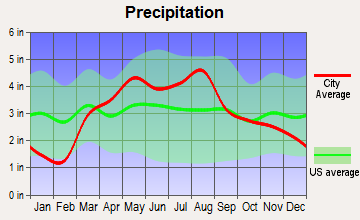
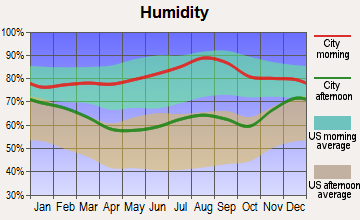
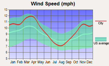
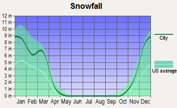
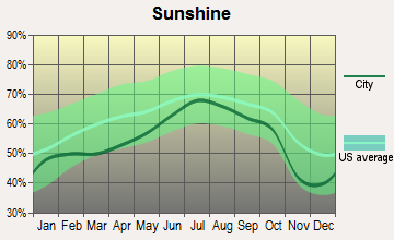
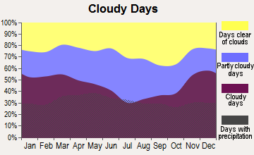
Air pollution and air quality trends (lower is better)
AQI CO NO2 SO2 Ozone PM10 PM2.5
Air Quality Index (AQI) level in 2023 was 98.5**. This is worse than average.**
Tornado activity:
Wheatland-area historical tornado activity is near Iowa state average. It is 85% greater than the overall U.S. average.
On 4/11/1965**, a** category F4 (max. wind speeds 207-260 mph) tornado 4.8 miles away from the Wheatland city center killed one person and injured 3 people and caused between 500,000∗∗and∗∗500,000 and 500,000∗∗and∗∗5,000,000 in damages.
On 5/8/1988**, a** category F3 (max. wind speeds 158-206 mph) tornado 6.5 miles away from the city center caused between 5,000,000∗∗and∗∗5,000,000 and 5,000,000∗∗and∗∗50,000,000 in damages.
Earthquake activity:
Wheatland-area historical earthquake activity is significantly above Iowa state average. It is 119% greater than the overall U.S. average.
On 4/18/2008 at 09:36:59**, a magnitude** 5.4 (5.1 MB**,** 4.8 MS**,** 5.4 MW**,** 5.2 MW**, Class:** Moderate**, Intensity:** VI - VII) earthquake occurred 281.2 miles away from Wheatland center
On 6/10/1987 at 23:48:54**, a magnitude** 5.1 (4.9 MB**,** 4.4 MS**,** 4.6 MS**,** 5.1 LG) earthquake occurred 260.1 miles away from the city center
On 4/18/2008 at 09:36:59**, a magnitude** 5.2 (5.2 MW**, Depth:** 8.9 mi) earthquake occurred 281.2 miles away from the city center
On 6/28/2004 at 06:10:52**, a magnitude** 4.2 (4.2 MW**, Depth:** 6.2 mi**, Class:** Light**, Intensity:** IV - V) earthquake occurred 103.5 miles away from the city center
On 6/18/2002 at 17:37:15**, a magnitude** 5.0 (4.3 MB**,** 4.6 MW**,** 5.0 LG) earthquake occurred 311.6 miles away from Wheatland center
On 4/18/2008 at 15:14:16**, a magnitude** 4.8 (4.5 MB**,** 4.8 MW**,** 4.6 MW) earthquake occurred 280.9 miles away from the city center
Magnitude types: regional Lg-wave magnitude (LG), body-wave magnitude (MB), surface-wave magnitude (MS), moment magnitude (MW)
Natural disasters:
The number of natural disasters in Clinton County (21) is greater than the US average (15).
Major Disasters (Presidential) Declared: 18
Emergencies Declared: 1
Causes of natural disasters: Floods: 16**, Storms:** 13**, Tornadoes:** 4**, Winter Storms:** 2**, Heavy Rain:** 1**, Hurricane:** 1**, Wind:** 1**, Other:** 1 (Note: some incidents may be assigned to more than one category).
Hospitals and medical centers in Wheatland:
- WHEATLAND MANOR (316 EAST LINCOLNWAY)
Other hospitals and medical centers near Wheatland:
- CLARENCE NURSING HOME (Nursing Home, about 13 miles away; CLARENCE, IA)
- DEWITT COMMUNITY HOSPITAL (Hospital, about 16 miles away; DE WITT, IA)
- GENESIS MEDICAL CENTER-DEWITT (Nursing Home, about 16 miles away; DE WITT, IA)
- CEDAR MANOR NURSING HOME (Nursing Home, about 16 miles away; TIPTON, IA)
- CEDAR COUNTY PHNS (Home Health Center, about 16 miles away; TIPTON, IA)
- COMMUNITY CARE INC (Home Health Center, about 16 miles away; DE WITT, IA)
Colleges/universities with over 2000 students nearest to Wheatland:
- Saint Ambrose University (about 25 miles; Davenport, IA; Full-time enrollment: 3,053)
- Kaplan University-Davenport Campus (about 25 miles; Davenport, IA; FT enrollment: 60,376)
- Eastern Iowa Community College District (about 26 miles; Davenport, IA; FT enrollment: 5,507)
- Augustana College (about 28 miles; Rock Island, IL; FT enrollment: 2,555)
- Black Hawk College (about 32 miles; Moline, IL; FT enrollment: 5,086)
- Ashford University (about 34 miles; Clinton, IA; FT enrollment: 73,330)
- University of Iowa (about 38 miles; Iowa City, IA; FT enrollment: 24,735)
See full list of schools located in Wheatland
Library in Wheatland:
- CURTIS MEMORIAL LIBRARY (Operating income: $31,890; Location: 116 S MAIN; 8,928 books; 276 audio materials; 266 video materials; 13 state licensed databases; 19 print serial subscriptions)
Points of interest:
Click to draw/clear city borders
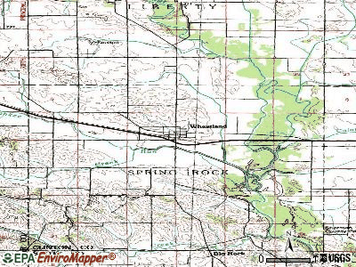
Notable locations in Wheatland: Wheatland (A), Wheatland Fire Department (B), Wheatland City Hall (C), Wheatland Library (D), Wheatland Emergency Medical Services Incorporated (E). Display/hide their locations on the map
Churches in Wheatland include: Christian Free Lutheran Church (A), Saint Pauls Church (B). Display/hide their locations on the map
Clinton County has a predicted average indoor radon screening level greater than 4 pCi/L (pico curies per liter) - Highest Potential
Average household size:
| This city: | 2.5 people |
|---|---|
| Iowa: | 2.4 people |
Percentage of family households:
| This city: | 67.0% |
|---|---|
| Whole state: | 64.7% |
Percentage of households with unmarried partners:
| This city: | 7.8% |
|---|---|
| Whole state: | 6.7% |
Likely homosexual households (counted as self-reported same-sex unmarried-partner households)
- Lesbian couples: 0.3% of all households
- Gay men: 0.0% of all households
38 people in nursing facilities/skilled-nursing facilities in 2010
45 people in nursing homes in 2000
Banks with branches in Wheatland (2011 data):
- First Trust and Savings Bank: First Trust And Savings Bank at 123 S. Main St., branch established on 1905/01/01**. Info updated** 2008/05/22: Bank assets: 123.2mil∗∗,Deposits:∗∗123.2 mil**, Deposits:** 123.2mil∗∗,Deposits:∗∗105.5 mil**, local headquarters** , positive income, Agricultural Specialization**,** 6 total offices , Holding Company: Wheatland Bancorporation
For population 15 years and over in Wheatland:
- Never married: 30.7%
- Now married: 33.6%
- Separated: 2.4%
- Widowed: 8.1%
- Divorced: 25.2%
For population 25 years and over in Wheatland:
- High school or higher: 91.9%
- Bachelor's degree or higher: 18.3%
- Graduate or professional degree: 2.5%
- Unemployed: 2.8%
- Mean travel time to work (commute): 25.9 minutes
Education Gini index (Inequality in education)
| Here: | 6.8 |
|---|---|
| Iowa average: | 10.5 |
Graphs represent county-level data. Detailed 2008 Election Results
Political contributions by individuals in Wheatland, IA
Religion statistics for Wheatland, IA (based on Clinton County data)
| Religion | Adherents | Congregations |
|---|---|---|
| Mainline Protestant | 10,135 | 33 |
| Catholic | 9,340 | 11 |
| Evangelical Protestant | 5,187 | 24 |
| Other | 1,061 | 10 |
| Black Protestant | 122 | 1 |
| None | 23,271 | - |
Source: Clifford Grammich, Kirk Hadaway, Richard Houseal, Dale E.Jones, Alexei Krindatch, Richie Stanley and Richard H.Taylor. 2012. 2010 U.S.Religion Census: Religious Congregations & Membership Study. Association of Statisticians of American Religious Bodies. Jones, Dale E., et al. 2002. Congregations and Membership in the United States 2000. Nashville, TN: Glenmary Research Center. Graphs represent county-level data
Food Environment Statistics:
**Number of grocery stores: 9
| Here: | 1.83 / 10,000 pop. |
|---|---|
| Iowa: | 2.14 / 10,000 pop. |
**Number of supercenters and club stores: 1
| This county: | 0.20 / 10,000 pop. |
|---|---|
| Iowa: | 0.23 / 10,000 pop. |
**Number of convenience stores (no gas): 2
| Clinton County: | 0.41 / 10,000 pop. |
|---|---|
| Iowa: | 0.43 / 10,000 pop. |
**Number of convenience stores (with gas): 28
| Clinton County: | 5.71 / 10,000 pop. |
|---|---|
| Iowa: | 5.55 / 10,000 pop. |
**Number of full-service restaurants: 35
| Clinton County: | 7.13 / 10,000 pop. |
|---|---|
| State: | 8.01 / 10,000 pop. |
**Adult obesity rate:
| This county: | 27.9% |
|---|---|
| State: | 27.3% |
**Low-income preschool obesity rate:
| Clinton County: | 14.6% |
|---|---|
| Iowa: | 14.5% |
Health and Nutrition:
**Average overall health of teeth and gums:
| This city: | 50.7% |
|---|---|
| State: | 46.1% |
**People feeling badly about themselves:
| This city: | 20.3% |
|---|---|
| Iowa: | 21.4% |
**People not drinking alcohol at all:
| Wheatland: | 13.7% |
|---|---|
| State: | 10.4% |
**Average hours sleeping at night:
**Overweight people:
| This city: | 42.2% |
|---|---|
| Iowa: | 33.8% |
**General health condition:
| Wheatland: | 56.6% |
|---|---|
| State: | 55.9% |
**Average condition of hearing:
| This city: | 79.3% |
|---|---|
| State: | 77.7% |
More about Health and Nutrition of Wheatland, IA Residents
| Local government employment and payroll (March 2022) | |||||
|---|---|---|---|---|---|
| Function | Full-time employees | Monthly full-time payroll | Average yearly full-time wage | Part-time employees | Monthly part-time payroll |
| Sewerage | 2 | 10,640∣10,640 | 10,640∣63,840 | 0 | $0 |
| Water Supply | 2 | 10,640∣10,640 | 10,640∣63,840 | 0 | $0 |
| Solid Waste Management | 2 | 10,640∣10,640 | 10,640∣63,840 | 0 | $0 |
| Other Government Administration | 1 | 4,203∣4,203 | 4,203∣50,436 | 0 | $0 |
| Streets and Highways | 0 | 0∣∣2∣0 | 2 | 0∣∣2∣1,632 | |
| Local Libraries | 0 | 0∣∣2∣0 | 2 | 0∣∣2∣5,891 | |
| Totals for Government | 7 | 36,121∣36,121 | 36,121∣61,922 | 4 | $7,523 |
Wheatland government finances - Expenditure in 2018 (per resident):
- Current Operations - Regular Highways: 250,000(250,000 (250,000(324.25)
Sewerage: 175,000(175,000 (175,000(226.98)
Local Fire Protection: 130,000(130,000 (130,000(168.61)
Water Utilities: 74,000(74,000 (74,000(95.98)
Solid Waste Management: 66,000(66,000 (66,000(85.60)
Libraries: 51,000(51,000 (51,000(66.15)
Financial Administration: 47,000(47,000 (47,000(60.96)
Police Protection: 17,000(17,000 (17,000(22.05)
Parks and Recreation: 15,000(15,000 (15,000(19.46)
General - Other: 11,000(11,000 (11,000(14.27)
Central Staff Services: 5,000(5,000 (5,000(6.49)
Health - Other: 5,000(5,000 (5,000(6.49)
Judicial and Legal Services: 2,000(2,000 (2,000(2.59)
Miscellaneous Commercial Activities - Other: 1,000(1,000 (1,000(1.30) - General - Interest on Debt: 42,000(42,000 (42,000(54.47)
- Total Salaries and Wages: 159,000(159,000 (159,000(206.23)
Wheatland government finances - Revenue in 2018 (per resident):
- Charges - Sewerage: 187,000(187,000 (187,000(242.54)
Solid Waste Management: 58,000(58,000 (58,000(75.23)
Other: 16,000(16,000 (16,000(20.75) - Local Intergovernmental - Other: 80,000(80,000 (80,000(103.76)
- Miscellaneous - Interest Earnings: 4,000(4,000 (4,000(5.19)
- Revenue - Water Utilities: 118,000(118,000 (118,000(153.05)
- State Intergovernmental - Highways: 99,000(99,000 (99,000(128.40)
- Tax - Property: 187,000(187,000 (187,000(242.54)
General Sales and Gross Receipts: 77,000(77,000 (77,000(99.87)
Other License: 1,000(1,000 (1,000(1.30)
Wheatland government finances - Debt in 2018 (per resident):
- Long Term Debt - Beginning Outstanding - Unspecified Public Purpose: 1,043,000(1,043,000 (1,043,000(1352.79)
Outstanding Unspecified Public Purpose: 960,000(960,000 (960,000(1245.14)
Retired Unspecified Public Purpose: 83,000(83,000 (83,000(107.65)
Wheatland government finances - Cash and Securities in 2018 (per resident):
- Other Funds - Cash and Securities: 358,000(358,000 (358,000(464.33)
- Sinking Funds - Cash and Securities: 317,000(317,000 (317,000(411.15)
Strongest AM radio stations in Wheatland:
- KXEL (1540 AM; 50 kW; WATERLOO, IA; Owner: KXEL BROADCASTING COMPANY, INC.)
- WMT (600 AM; 5 kW; CEDAR RAPIDS, IA; Owner: CITICASTERS LICENSES, L.P.)
- WOC (1420 AM; 5 kW; DAVENPORT, IA; Owner: CITICASTERS LICENSES, L.P.)
- KCJJ (1630 AM; 10 kW; IOWA CITY, IA; Owner: RIVER CITY RADIO, INC.)
- WKBF (1270 AM; 5 kW; ROCK ISLAND, IL; Owner: MERCURY BROADCASTING COMPANY, INC.)
- WSCR (670 AM; 50 kW; CHICAGO, IL; Owner: INFINITY BROADCASTING OPERATIONS, INC.)
- WSUI (910 AM; 5 kW; IOWA CITY, IA; Owner: THE UNIVERSITY OF IOWA)
- WTMJ (620 AM; 50 kW; MILWAUKEE, WI; Owner: JOURNAL BROADCAST CORPORATION)
- WGN (720 AM; 50 kW; CHICAGO, IL; Owner: WGN CONTINENTAL BROADCASTING CO.)
- WBBM (780 AM; 50 kW; CHICAGO, IL; Owner: INFINITY BROADCASTING OPERATIONS, INC.)
- WHO (1040 AM; 50 kW; DES MOINES, IA; Owner: CITICASTERS LICENSES, L.P.)
- KCRG (1600 AM; 5 kW; CEDAR RAPIDS, IA; Owner: CEDAR RAPIDS TELEVISION CO.)
- WMVP (1000 AM; 50 kW; CHICAGO, IL; Owner: ABC, INC.)
Strongest FM radio stations in Wheatland:
- KSUI (91.7 FM; IOWA CITY, IA; Owner: THE UNIVERSITY OF IOWA)
- WLLR-FM (103.7 FM; DAVENPORT, IA; Owner: CITICASTERS LICENSES, L.P.)
- WVIK (90.3 FM; ROCK ISLAND, IL; Owner: AUGUSTANA COLLEGE)
- KCQQ (106.5 FM; DAVENPORT, IA; Owner: CITICASTERS LICENSES, L.P.)
- KMXG (96.1 FM; CLINTON, IA; Owner: CITICASTERS LICENSES, L.P.)
- KBOB-FM (104.9 FM; GENESEO, IL; Owner: CUMULUS LICENSING CORP.)
- KUUL (101.3 FM; EAST MOLINE, IL; Owner: CITICASTERS LICENSES, L.P.)
- KBEA-FM (99.7 FM; MUSCATINE, IA; Owner: CUMULUS LICENSING CORP.)
- WHTS (98.9 FM; ROCK ISLAND, IL; Owner: MERCURY BROADCASTING COMPANY, INC.)
- WDLM-FM (89.3 FM; EAST MOLINE, IL; Owner: THE MOODY BIBLE INSTITUTE OF CHICAGO)
- KMAQ-FM (95.1 FM; MAQUOKETA, IA; Owner: MAQUOKETA BROADCASTING COMPANY)
TV broadcast stations around Wheatland:
- K16EL (Channel 66; DAVENPORT, IA; Owner: THREE ANGELS BROADCASTING NETWORK)
- KIIN (Channel 12; IOWA CITY, IA; Owner: IOWA PUBLIC BROADCASTING BOARD)
- KWKB (Channel 20; IOWA CITY, IA; Owner: KM TELEVISION OF IOWA, L.L.C.)
- WHBF-TV (Channel 4; ROCK ISLAND, IL; Owner: CORONET COMMUNICATIONS COMPANY)
- WBQD-LP (Channel 26; DAVENPORT, IA; Owner: FOUR SEASONS PEORIA, LLC)
- KFXA (Channel 28; CEDAR RAPIDS, IA; Owner: SECOND GENERATION OF IOWA, LTD.)
- KWQC-TV (Channel 6; DAVENPORT, IA; Owner: YOUNG BROADCASTING OF DAVENPORT, INC.)
- KLJB-TV (Channel 18; DAVENPORT, IA; Owner: QUAD CITIES TELEVISION ACQUISITION CORP.)
- WQAD-TV (Channel 8; MOLINE, IL; Owner: NEW YORK TIMES MANAGEMENT SERVICES)
- K61HD (Channel 61; DAVENPORT, IA; Owner: TRINITY BROADCASTING NETWORK)
- KQIN (Channel 36; DAVENPORT, IA; Owner: IOWA PUBLIC BROADCASTING BOARD)
Wheatland fatal accident list:
Aug 3, 2004 03:30 AM, Us-30, Vehicles: 1, Persons: 1, Fatalities: 1
Jan 20, 1996 01:13 PM, 30, Vehicles: 2, Persons: 4, Fatalities: 1
Aug 13, 1978 08:05 AM, Vehicles: 2, Persons: 2, Fatalities: 1
- National Bridge Inventory (NBI) Statistics
- 18Number of bridges
- 230ft / 69.5mTotal length
- 9,985Total average daily traffic
- 1,869Total average daily truck traffic
- 11,145Total future (year 2037) average daily traffic
- New bridges - historical statistics
- 11920-1929
- 11930-1939
- 31950-1959
- 21960-1969
- 11980-1989
- 21990-1999
- 52000-2009
- 32010-2019
See full National Bridge Inventory statistics for Wheatland, IA
FCC Registered Antenna Towers:
11 (See the full list of FCC Registered Antenna Towers in Wheatland)
FCC Registered Broadcast Land Mobile Towers:
2
- MP 34.16, Mp 34.16 Clinton Sub (Lat: 41.827667 Lon: -90.827889), Type: Pole, Structure height: 4 m, Call Sign: WQNJ460,
Assigned Frequencies: 160.890 MHz, 161.040 MHz, Grant Date: 01/21/2021, Expiration Date: 02/23/2031, Certifier: Larry J Kopiasz, Registrant: Prokarma, 222 So 15th St. Suite 505n, Omaha, NE 68102, Phone: (402) 522-5068, Fax: (402) 346-6676, Email: - Lat: 41.980556 Lon: -90.867222, Call Sign: WQSH436,
Assigned Frequencies: 151.490 MHz, Grant Date: 09/19/2013, Expiration Date: 09/19/2023, Cancellation Date: 11/25/2023, Certifier: David Schneider, Registrant: Midwest Wireless, 5915 Brady Street, Davenport, IA 52806, Phone: (563) 386-9011, Fax: (563) 386-9011, Email:
FCC Registered Microwave Towers:
5
- clin3 3619 1, Lat: 41.835833 Lon: -90.864722, Type: Mtower, Structure height: 18 m, Overall height: 19 m, Call Sign: WQKA204,
Assigned Frequencies: 3650.00 MHz, Grant Date: 03/03/2009, Expiration Date: 03/03/2019, Cancellation Date: 05/04/2019, Certifier: William J Wax, Registrant: Breeze Broadband Communications, Inc., 1400 Douglas Street, Mail Stop 680, Omaha, NE 68179, Phone: (402) 544-4040, Email: - clin3 3417 1, Lat: 41.827500 Lon: -90.827778, Type: Mtower, Structure height: 18 m, Overall height: 19 m, Call Sign: WQKA204,
Assigned Frequencies: 3650.00 MHz, Grant Date: 03/03/2009, Expiration Date: 03/03/2019, Cancellation Date: 05/04/2019, Certifier: William J Wax, Registrant: Breeze Broadband Communications, Inc., 1400 Douglas Street, Mail Stop 680, Omaha, NE 68179, Phone: (402) 544-4040, Email: - WHEATLAND, 2317 130th Ave (Lat: 41.841028 Lon: -90.839528), Type: Tower, Structure height: 57.9 m, Overall height: 60.6 m, Call Sign: WQLC341,
Assigned Frequencies: 10572.5 MHz, Grant Date: 12/01/2009, Expiration Date: 12/01/2019, Cancellation Date: 09/05/2018, Certifier: John E Rooney, Registrant: Holland & Knight LLP, 800 17th Street, N.W., Suite #1100, Washington, DC 20006-3906, Phone: (202) 955-3000, Fax: (202) 955-5564, Email: - WHEATLAND, 2262 120th Ave. (Lat: 41.844667 Lon: -90.859833), Type: Gtower, Structure height: 59.4 m, Overall height: 60.6 m, Call Sign: WRAM646, Licensee ID: L02059070,
Assigned Frequencies: 11265.0 MHz, 11305.0 MHz, 11265.0 MHz, 11305.0 MHz, 11305.0 MHz, 11265.0 MHz, 11305.0 MHz, 11265.0 MHz, 11265.0 MHz, 11305.0 MHz... (+8 more), Grant Date: 01/09/2018, Expiration Date: 01/09/2028, Certifier: David Byers, Registrant: Cover 2, LLC, 800 S Main Street, Monona, IA 52159, Phone: (563) 539-2122, Fax: (563) 539-2003, Email: - DM05713A, 2262 120th Ave. (Lat: 41.844667 Lon: -90.859833), Type: Ltower, Structure height: 59.4 m, Overall height: 60.6 m, Call Sign: WRVH568,
Assigned Frequencies: 11485.0 MHz, 11485.0 MHz, 11485.0 MHz, 11485.0 MHz, 11485.0 MHz, 11485.0 MHz, 11485.0 MHz, 11485.0 MHz, 11485.0 MHz, 11485.0 MHz, 11485.0 MHz, Grant Date: 11/22/2022, Expiration Date: 11/22/2032, Certifier: Jenny Knopf, Registrant: T-Mobile Usa, Inc., 12920 Se 38th Street, Bellevue, WA 98006, Phone: (425) 383-8401, Fax: (425) 383-4040, Email:
FCC Registered Amateur Radio Licenses:
14 (See the full list of FCC Registered Amateur Radio Licenses in Wheatland)
FAA Registered Aircraft:
3
- Aircraft: MUELLER MICHAEL WALTER CHALLENGER II CW SPC (Category: Land, Seats: 2, Weight: Up to 12,499 Pounds), Engine: ROTAX SEE BOMBADIER (Reciprocating)
N-Number: 530MW, N530MW, N-530MW, Serial Number: CH11-0293-CW-0949, Year manufactured: 2003, Airworthiness Date: 08/27/2003, Certificate Issue Date: 11/21/2013
Registrant (Individual): Mark Hartbecke, 1995 150th Ave, Wheatland, IA 52777 - Aircraft: CESSNA 120 (Category: Land, Seats: 2, Weight: Up to 12,499 Pounds, Speed: 90 mph), Engine: CONT MOTOR C85 SERIES (85 HP) (Reciprocating)
N-Number: 76634, N76634, N-76634, Serial Number: 11074, Year manufactured: 1946, Airworthiness Date: 11/26/1955, Certificate Issue Date: 12/23/2013
Registrant (Individual): Roger C Blunk, 216 E Lincolnway St, Wheatland, IA 52777 - Aircraft: CIRRUS DESIGN CORP SR22T (Category: Land, Seats: 5, Weight: Up to 12,499 Pounds), Engine: CONT MOTOR TSIO-550-K (315 HP) (Reciprocating)
N-Number: 773GB, N773GB, N-773GB, Serial Number: 0702, Year manufactured: 2014, Airworthiness Date: 01/30/2014, Certificate Issue Date: 05/22/2017
Registrant (LLC): Jkc LLC, 2594 112th Ave, Wheatland, IA 52777
2002 - 2017 National Fire Incident Reporting System (NFIRS) incidents
See full National Fire Incident Reporting System statistics for Wheatland, IA
| Most common first names in Wheatland, IA among deceased individuals | ||
|---|---|---|
| Name | Count | Lived (average) |
| John | 14 | 78.6 years |
| William | 14 | 78.9 years |
| Anna | 11 | 89.4 years |
| Edward | 8 | 76.2 years |
| Marie | 8 | 87.9 years |
| Robert | 8 | 75.5 years |
| Clara | 8 | 83.2 years |
| Walter | 7 | 77.0 years |
| Mary | 7 | 79.7 years |
| Fred | 6 | 81.5 years |
| Most common last names in Wheatland, IA among deceased individuals | ||
|---|---|---|
| Last name | Count | Lived (average) |
| Riedesel | 19 | 83.1 years |
| Petersen | 18 | 78.1 years |
| Schneider | 16 | 82.2 years |
| Fox | 12 | 74.4 years |
| Knoche | 8 | 74.5 years |
| Horstmann | 6 | 83.6 years |
| Schutt | 6 | 83.2 years |
| Smith | 6 | 81.0 years |
| Kelting | 5 | 88.2 years |
| Rowold | 5 | 76.6 years |
- 50.0%Utility gas
- 42.7%Bottled, tank, or LP gas
- 5.0%Electricity
- 1.1%Fuel oil, kerosene, etc.
- 0.8%No fuel used
- 0.4%Wood
Wheatland compared to Iowa state average:
- Median household income below state average.
- Median house value below state average.
- Unemployed percentage significantly below state average.
- Black race population percentage significantly below state average.
- Foreign-born population percentage significantly below state average.
- Length of stay since moving in significantly above state average.
- House age above state average.
- Institutionalized population percentage above state average.
- Number of college students significantly below state average.
There are 2 pilots and no other airmen in this city.
