Shiyan (original) (raw)

Home - Search - Browse - Alphabetic Index: 0- 1- 2- 3- 4- 5- 6- 7- 8- 9
A- B- C- D- E- F- G- H- I- J- K- L- M- N- O- P- Q- R- S- T- U- V- W- X- Y- Z
Shiyan

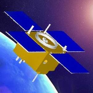
Tansuo 1
Credit: Manufacturer Image
Chinese civilian surveillance satellite. The first 'Experiment Satellite', with a mass of 204 kg, was China's first transmission-type small satellite capable of stereo mapping.
AKA: Experiment Satellite I;Tansuo-1;TS-1. Status: Operational 2004. First Launch: 2004-04-18. Last Launch: 2011-11-20. Number: 2 . Gross mass: 204 kg (449 lb).
It was jointly designed by the Harbin Polytechnic University, Chinese Research Institute of Space Technology, Changchun Photomechanical Institute of the Chinese Academy of Sciences (CAS) and Xian Surveys and Designs Institute. It seems to have been derived from the Tansuo-1 (Exploration-1) high-resolution imaging microsatellite, developed by the Harbin Institute of Technology (HIT) and announced in early June 2000. This satellite was to have been launched in 2001, but never appeared. Tansuo-1 was a 150-kg microsatellite with a 10-meter stereo resolution camera. It was developed in collaboration with the European Astrium Corporation.
The satellite was, officially, mainly to be used to carry out a photographic survey of China's land resources, monitor its geographical environment and conduct scientific mapping research. It was to be handed over to the Satellite Remote-Sensing Ground Station of CAS following the on-orbit testing.
Family: Civilian surveillance satellite, Earth, Surveillance, Technology. Country: China. Launch Vehicles: Chang Zheng 2C, Chang Zheng 2D. Launch Sites: Jiuquan, Xichang, Xichang LC1. Agency: Harbin. Bibliography: 2, 6872, 13089.
Photo Gallery
 |
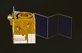
Shiyan 5 WeixingCredit: Manufacturer Image |
|---|
2004 April 18 - . 15:59 GMT - . Launch Site: Xichang. Launch Complex: Xichang LC1. Launch Pad: LC1?. LV Family: CZ. Launch Vehicle: Chang Zheng 2C.
- Tansuo 1 - . Payload: Shiyan 1. Mass: 204 kg (449 lb). Nation: China. Agency: Harbin. Class: Technology. Type: Navigation technology satellite. Spacecraft: Shiyan. USAF Sat Cat: 28220 . COSPAR: 2004-012A. Apogee: 616 km (382 mi). Perigee: 598 km (371 mi). Inclination: 97.70 deg. Period: 96.80 min.
China's first transmission-type small satellite capable of stereo mapping. It was jointly designed by the Harbin Polytechnic University, Chinese Research Institute of Space Technology, Changchun Photomechanical Institute of the Chinese Academy of Sciences (CAS)and Xi'an Surveys and Designs Institute. The experiment satellite carried out photographic surveys of China's land resources, monitored the geographical environment and conducted scientific research on mapping. It was handed over for use to the Satellite Remote-Sensing Ground Station of CAS following the on-orbit testing.
2011 November 20 - . 00:15 GMT - . Launch Site: Jiuquan. LV Family: CZ. Launch Vehicle: Chang Zheng 2D.
- Shiyan 4 - . Mass: 204 kg (449 lb). Nation: China. Class: Earth. Type: Earth resources satellite. Spacecraft: Shiyan. USAF Sat Cat: 37931 . COSPAR: 2011-068B. Apogee: 803 km (498 mi). Perigee: 784 km (487 mi). Inclination: 98.50 deg. Period: 100.70 min. Civilian resource satellite with digital imaging system capable of stereo Earth-terrain mapping..
Home - Search - Browse - Alphabetic Index: 0- 1- 2- 3- 4- 5- 6- 7- 8- 9
A- B- C- D- E- F- G- H- I- J- K- L- M- N- O- P- Q- R- S- T- U- V- W- X- Y- Z
© 1997-2019 Mark Wade - Contact
© / Conditions for Use