ADEOS (original) (raw)

Home - Search - Browse - Alphabetic Index: 0- 1- 2- 3- 4- 5- 6- 7- 8- 9
A- B- C- D- E- F- G- H- I- J- K- L- M- N- O- P- Q- R- S- T- U- V- W- X- Y- Z
ADEOS
Japanese earth atmosphere satellite. The polar orbiting ADEOS spacecraft was to perform Earth, atmospheric, and oceanographic remote sensing. Earth Observation satellite built by Mitsubishi Electric (MELCO) for NASDA, Japan. Launched 1996.
AKA: Advanced Earth Observation Satellite;Midori. Status: Operational 1996. First Launch: 1996-08-17. Last Launch: 2002-12-14. Number: 2 . Gross mass: 135 kg (297 lb). Height: 5.00 m (16.40 ft). Span: 26.00 m (85.00 ft).
ADEOS 1 and 2 used the same bus design to fly different instrument suites. These were the largest satellites Japan had ever developed.
Several of the instruments on ADEOS were provided by NASA, NOAA, and CNES. The launch of ADEOS 2 was planned initially for early 1999. The spacecraft used a 3-Axis stabilized, zero momentum biased control system with 0.3 deg control and 0.003 deg/sec stability using reaction wheels. A single solar array generated 4.5 kW for a 34 to 52 volt floating bus with 5x35 AHr NiCd batteries. A hydrazine propulsion system with 135 kg fuel provided orbit maintenance. S-Band TT&C (S-Band, Uplink: 500 bps, Downlink: 4 Mbps). Ka-Band data crosslink at 120 Mbps to COMETS. X-Band direct downlink (40W and 8W, QPSK). System reliability was 0.7 at 3 years.
Payloads:
ADEOS-1:
- AVNIR (Advanced Visible and Near-Infrared Radiometer): five visible/near-infrared bands (0.42 to 0.89 �m); 16- or 8-m resolution; 80 km swath; +/- 40 deg cross-track pointing; stereo capability (from NASDA).
- ILAS (Infrared Limb Atmospheric Spectrometer): infrared occultation device (from Japan's Environmental Agency).
- IMG: nadir-looking Fourier transform infrared spectrometer (from MITI).
- NSCAT: active Ku-band scatterometer (from NASA).
- OCTS: Ocean Color Temperature Scanner (from NASDA).
- POLDER: (from CNES).
- RIS: (from Japan's Environmental agency).
- TOMS: Total Ozone Mapping Spectrometer (from NASA).
ADEOS-2 Payload
ADEOS-1:
- AMSR (Advanced Microwave Scanning Radiometer)
- GLI (Global Imager)
- Sea Winds
- POLDER (Polarization and Directionality of the Earth's Reflectance)
- ILAS-II (Improved Limb Atmospheric Spectrometer-II)
Financial/Operational:
Initially put on 20 August 1996 into the wrong orbit - an acceptable orbit was achieved in September 1996. The spacecraft failed on 30 June 1997. Cost was $ 986 million total - $ 808 million for the satellite and $ 178 million for the launch. Electric System: 4.50 average kW.
NASA NSSDC Master Catalog Description
The Japanese Advanced Earth Observing Satellite (ADEOS) was developed to establish platform technology for Earth Observing System (EOS) spacecraft and inter-orbit communication technology for the transmission of Earth observation data. In addition, ADEOS contributed global observation of environmental change to the international community during the pre-EOS era. NASA's Mission to Planet Earth (MTPE) program contributed two instruments for the ADEOS mission.
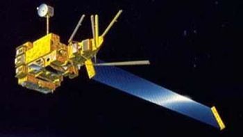
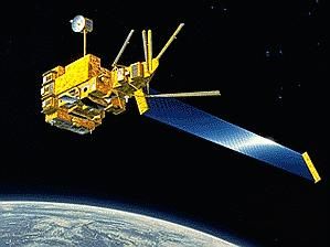
ADEOS was a sun-synchronous, morning equator-crossing (in descending node at about 10:30 a.m.), polar orbiting spacecraft. It had a modular type shape with a deployable one wing solar paddle. The body measured 4 x 4 x 5 m and the solar paddle was 3 x 13 m in size.
ADEOS was three-axis stabilized by a zero momentum strap-down attitude-control system. Attitude was maintained by four reaction wheels, two magnetometers, an inertial reference unit, and two hydrazine thrusters. Power was provided by a single gallium arsenide flexible solar paddle and five 35 A-hr NiCd batteries. Data was transmitted via direct transmission and inter-orbit communication through ETS-6. A Mission Data Recorder system on-board ADEOS stored high data rate and low data rate data on separate tape recorders.
Eight experiments on ADEOS included: (1) Ocean Color and Temperature Scanner (OCTS), a NASDA core instrument; (2) Advanced Visible and Near-Infrared Radiometer (AVNIR), a NASDA core instrument; (3) NASA Scatterometer (NSCAT), a NASA/MTPE-provided instrument; (4) Total Ozone Mapping Spectrometer (TOMS), a NASA/MTPE provided instrument; (5) Polarization and Directionality of the Earth's Reflectances (POLDER), provided by CNES of France; (6) Interferometric Monitor for Greenhouse Gases (IMG), provided by MITI of Japan; (7) Improved Limb Atmospheric Spectrometer (ILAS), provided by Environmental Agency of Japan; and, (8) Retroreflector in Space (RIS), provided by the Environmental Agency of Japan.
The design lifetime for this mission was three years, but the spacecraft ceased operating on 30 June 1997 for as yet unknown reasons. Subsequent flights of ADEOS are planned during the EOS era.
More at: ADEOS.
Family: Atmosphere sat, Earth, Sun synchronous orbit. Country: Japan. Launch Vehicles: Ariane 44L, H-II, H-IIA 202. Launch Sites: Tanegashima, Tanegashima Y. Agency: NASDA, Mitsubishi. Bibliography: 2, 4, 4064, 552, 554, 12023, 12024.
Photo Gallery
 |
ADEOSCredit: Manufacturer Image |
|---|
 |
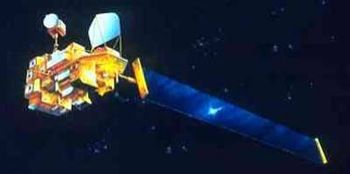
Adeos 2Credit: Manufacturer Image |
|---|
1996 August 17 - . 01:53 GMT - . Launch Site: Tanegashima. Launch Complex: Tanegashima Y. LV Family: H-2. Launch Vehicle: H-II.
- ADEOS - . Mass: 135 kg (297 lb). Nation: Japan. Agency: NASDA. Class: Earth. Type: Atmosphere satellite. Spacecraft: ADEOS. USAF Sat Cat: 24277 . COSPAR: 1996-046A. Apogee: 800 km (490 mi). Perigee: 799 km (496 mi). Inclination: 98.60 deg. Period: 100.90 min.
1997 June 30 - .
- ADEOS spacecraft fails - . Nation: Japan. Spacecraft: ADEOS. The polar orbiting ADEOS spacecraft performed Earth, atmospheric, and oceanographic remote sensing. Initially put on August 20 1996 into a wrong orbit, it achieved an acceptable orbit in September 1996..
2002 December 14 - . 23:04 GMT - . Launch Site: Tanegashima. Launch Complex: Tanegashima Y. LV Family: H-2. Launch Vehicle: H-IIA 202.
- Adeos 2 - . Payload: Midori 2. Mass: 3,730 kg (8,220 lb). Nation: Japan. Agency: NASDA. Manufacturer: Mitsubishi. Class: Earth. Type: Earth resources satellite. Spacecraft: Adeos. USAF Sat Cat: 27597 . COSPAR: 2002-056A. Apogee: 806 km (500 mi). Perigee: 804 km (499 mi). Inclination: 98.70 deg. Period: 101.00 min. Environment Monitoring, Aeronomy..
Home - Search - Browse - Alphabetic Index: 0- 1- 2- 3- 4- 5- 6- 7- 8- 9
A- B- C- D- E- F- G- H- I- J- K- L- M- N- O- P- Q- R- S- T- U- V- W- X- Y- Z
© 1997-2019 Mark Wade - Contact
© / Conditions for Use
