I-1K (original) (raw)

Home - Search - Browse - Alphabetic Index: 0- 1- 2- 3- 4- 5- 6- 7- 8- 9
A- B- C- D- E- F- G- H- I- J- K- L- M- N- O- P- Q- R- S- T- U- V- W- X- Y- Z
I-1K

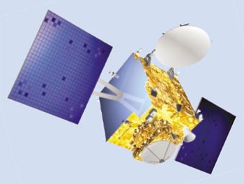
Gsat 12
Credit: Manufacturer Image
Indian 1000-kg class satellite bus for use in geostationary or planetary missions. Dimensions 1.505 m � 1.476 m � 1.530 m, dry mass 500 kg, payload 100 kg, power system up to 1000 watts, design life 7 years.
Status: Operational 2002. First Launch: 2002-09-12. Last Launch: 2015-03-28. Number: 6 .
More at: I-1K.
Subtopics
| IRNSS Indian operational navigation satellite series, part of the Indian Regional Navigation Satellite System. Provided L-band and S-band navigation signals. Navigation satellite for ISRO, India. Launched 2013-2016. Used the I-1K (I-1000) Bus bus. |
|---|
Family: Communications, Earth, Navigation. Country: India. Launch Vehicles: PSLV, PSLV-XL. Launch Sites: Sriharikota, Sriharikota PSLV, Sriharikota SLP. Bibliography: 6577, 12626, 12627.
Photo Gallery
 |
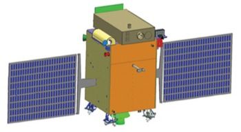
Aditya 1Credit: Manufacturer Image |
|---|
 |
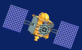
IRNSS-1CCredit: Manufacturer Image |
|---|
 |
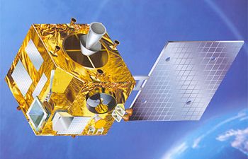
Metsat 1Credit: Manufacturer Image |
|---|
2002 September 12 - . 10:25 GMT - . Launch Site: Sriharikota. Launch Complex: Sriharikota PSLV. Launch Vehicle: PSLV.
- Metsat 1 - . Mass: 1,000 kg (2,200 lb). Nation: Europe. Agency: ISRO. Class: Earth. Type: Weather satellite. Spacecraft: I-1K. USAF Sat Cat: 27525 . COSPAR: 2002-043A. Apogee: 35,809 km (22,250 mi). Perigee: 35,764 km (22,222 mi). Inclination: 0.30 deg. Period: 1,436.10 min.
METSAT 1 was an Indian (ISRO) meteorological, geostationary satellite that was launched by an upgraded, four-stage PSLV-C4 rocket. The satellite was manoeuvred from the transfer orbit to a geostationary postion at 37� E longitude on September 16, and then was parked at 74� E longitude on September 24. As of 2007 Mar 11 located at 74.00E drifting at 0.007W degrees per day.
2011 July 15 - . 11:18 GMT - . Launch Site: Sriharikota. Launch Complex: Sriharikota PSLV. LV Family: PSLV. Launch Vehicle: PSLV-XL.
- GSAT-12 - . Mass: 1,410 kg (3,100 lb). Nation: India. Program: Insat. Class: Communications. Type: Civilian communications satellite. Spacecraft: I-1K. USAF Sat Cat: 37746 . COSPAR: 2011-034A. Apogee: 35,806 km (22,248 mi). Perigee: 35,768 km (22,225 mi). Inclination: 0.10 deg. Period: 1,436.10 min. Communications satellite; used on-board propellant to reach geosynchronous position..
2013 July 1 - . 18:11 GMT - . Launch Site: Sriharikota. Launch Complex: Sriharikota PSLV. Launch Pad: LP1. LV Family: PSLV. Launch Vehicle: PSLV-XL.
- IRNSS-1A - . Mass: 1,425 kg (3,141 lb). Nation: India. Class: Navigation. Type: Navigation satellite. Spacecraft: I-1K. USAF Sat Cat: 39199 . COSPAR: 2013-034A. Apogee: 35,866 km (22,286 mi). Perigee: 35,706 km (22,186 mi). Inclination: 27.35 deg. Period: 1,436.06 min. First Indian operational navigation satellite, beginning the Indian Regional Navigation Satellite System. Provides L-band and S-band navigation signals..
2014 April 4 - . 11:44 GMT - . Launch Site: Sriharikota. Launch Complex: Sriharikota SLP. Launch Pad: PSLV. LV Family: PSLV. Launch Vehicle: PSLV-XL.
- IRNSS-1B - . Mass: 1,425 kg (3,141 lb). Nation: India. Class: Navigation. Type: Navigation satellite. Spacecraft: I-1K. USAF Sat Cat: 39635 . COSPAR: 2014-017A. Apogee: 35,883 km (22,296 mi). Perigee: 35,688 km (22,175 mi). Inclination: 30.89 deg. Period: 1,436.03 min.
Second dedicated navigation satellite for the Indian Regional Navigation Satellite System. After a coast phase the fourth stage ignited to accelerate the vehicle to a 269 x 20,558 km x 19.3 deg transfer orbit. IRNSS-1B used its onboard engine to join IRNSS-1A in circular inclined geosynchronous orbit, and on April 17 was in a 35,565 x 35,878 km x 31.0 deg orbit over the Indian Ocean.
2014 October 15 - . 20:02 GMT - . Launch Site: Sriharikota. Launch Complex: Sriharikota SLP. Launch Pad: Sriharikota FLP. LV Family: PSLV. Launch Vehicle: PSLV-XL.
- IRNSS-1C - . Mass: 1,425 kg (3,141 lb). Nation: India. Class: Navigation. Type: Navigation satellite. Spacecraft: I-1K. USAF Sat Cat: 40269 . COSPAR: 2014-061A. Apogee: 35,879 km (22,294 mi). Perigee: 35,696 km (22,180 mi). Inclination: 4.17 deg. Period: 1,436.14 min. India's third dedicated navigation satellite. Stationed in geosynchronous orbit at 83 deg east..
2015 March 28 - . 11:49 GMT - . Launch Site: Sriharikota. Launch Complex: Sriharikota. LV Family: PSLV. Launch Vehicle: PSLV-XL.
- IRNSS-1D - . Mass: 1,425 kg (3,141 lb). Nation: India. Class: Navigation. Type: Navigation satellite. Spacecraft: I-1K. USAF Sat Cat: 40547 . COSPAR: 2015-018A. Apogee: 35,869 km (22,287 mi). Perigee: 35,707 km (22,187 mi). Inclination: 30.11 deg. Period: 1,436.18 min. Fourth Indian Regional Navigation Satellite System satellite; joined its siblings IRNSS-1A and 1B in inclined synchronous orbit..
2016 January 20 - . 04:01 GMT - . Launch Site: Sriharikota. Launch Complex: Sriharikota SLP. LV Family: PSLV. Launch Vehicle: PSLV-XL.
- IRNSS-1E - . Mass: 1,425 kg (3,141 lb). Nation: USA. Class: Navigation. Type: Navigation satellite. Spacecraft: I-1K. USAF Sat Cat: 41241 . COSPAR: 2016-003A. Apogee: 20,547 km (12,767 mi). Perigee: 288 km (178 mi). Inclination: 19.20 deg.
India launched its 5th navigation satellite. The PSLV-XL delivered it to a subsynchronous transfer orbit. By early February it was in an inclined synchronous orbit at 35697 x 35874 km x 28.1 deg. IRNSS-R1C was in an near-equatorial orbit at 83E; the remainder are in the 28 degree inclined orbits, with R1A and R1B over about 55E and R1D and R1E over about 112E.
2016 March 10 - . 10:31 GMT - . Launch Site: Sriharikota. Launch Complex: Sriharikota SLP. LV Family: PSLV. Launch Vehicle: PSLV-XL.
- IRNSS-1F - . Mass: 1,425 kg (3,141 lb). Nation: USA. Class: Navigation. Type: Navigation satellite. Spacecraft: I-1K. USAF Sat Cat: 41384 . COSPAR: 2016-015A. Apogee: 35,750 km (22,210 mi). Perigee: 33,349 km (20,722 mi). Inclination: 5.30 deg.
Indian Regional Navigation Satellite System was augmented by launch of the 1F satellite. The initial insertion orbit was 270 x 20649 km x 17.9 deg; an initial perigee burn to raise apogee was followed by several apogee burns towards circular inclined synchronous orbit.
2016 April 28 - . 07:20 GMT - . Launch Site: Sriharikota. Launch Complex: Sriharikota PSLV. LV Family: PSLV. Launch Vehicle: PSLV-XL.
- IRNSS-1G - . Mass: 1,425 kg (3,141 lb). Nation: USA. Class: Navigation. Type: Navigation satellite. Spacecraft: I-1K. USAF Sat Cat: 41469 . COSPAR: 2016-027A. Apogee: 35,821 km (22,258 mi). Perigee: 35,741 km (22,208 mi). Inclination: 5.10 deg. Launch of the IRNSS-1G completed India's 7-satellite navigation constellation. Placed in geosynchronous orbit at 129 deg E..
Home - Search - Browse - Alphabetic Index: 0- 1- 2- 3- 4- 5- 6- 7- 8- 9
A- B- C- D- E- F- G- H- I- J- K- L- M- N- O- P- Q- R- S- T- U- V- W- X- Y- Z
© 1997-2019 Mark Wade - Contact
© / Conditions for Use