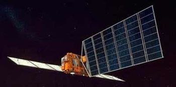
JERS (original) (raw)

Home - Search - Browse - Alphabetic Index: 0- 1- 2- 3- 4- 5- 6- 7- 8- 9
A- B- C- D- E- F- G- H- I- J- K- L- M- N- O- P- Q- R- S- T- U- V- W- X- Y- Z
JERS

JERS-1
Credit: Manufacturer Image
Japanese earth land resources satellite. JERS-1 (Japanese Research Satellite-1; FUYO-1) was Japan's second Earth observation satellite. Earth Observation, radar & optical satellite built by Mitsubishi Electric (MELCO) for NASDA, Japan. Launched 1992.
AKA: ERS;Japanese Earth Resources Satellite. Status: Operational 1992. First Launch: 1992-02-11. Last Launch: 1992-02-11. Number: 1 . Gross mass: 1,340 kg (2,950 lb). Height: 3.10 m (10.10 ft). Span: 12.00 m (39.00 ft).
Its mission was to verify functions and performance of optical sensors and a Synthetic Aperture Radar.
Mitsubishi Electric Co. (MELCO) was the prime contractor, and the launching organization was NASDA. JERS was designed to provide global, all-weather imaging capability for agriculture, forestry, fishery, environmental protection, and disaster protection use. It would form part of an integrated system for observing the Earth's resources; to perform observations and measurements for land survey, agriculture, forestry, fishery, environmental preservation, disaster prevention and coastal surveillance. Some data would be also shared with the University of Alaska for research uses. The spacecraft was a 3-axis stabilized, zero momentum bias system with magnetotorquers, reaction wheels. Earth and sun sensors provided 0.3 deg attitude knowledge. The satellite used a hydrazine propulsion system and a 72 Gbit solid state recorder. The single solar panel was 3.4 m x 8 m, provided 2050 W BOL, and recharged 4 x 30 Ahr NiCd batteries.
The SAR (Synthetic Aperture Radar) was L-band using HH polarization with a 35 deg look angle. The SAR had 18 m resolution (3 looks) with a 75 km swath and used a corporate feed antenna 11.9 m x 2.4 m. The Optical Sensor (OPS) could observe in 7 bands from visible to short wave infrared with stereoscopic imaging by a forward look of 15.3 deg, and provided 18 m resolution.
More at: JERS.
Family: Earth, Earth land resource sat, Sun synchronous orbit. Country: Japan. Launch Vehicles: Thor, Delta, H-1. Launch Sites: Tanegashima, Tanegashima N. Agency: NASDA, Mitsubishi. Bibliography: 2, 279, 6, 6608, 12703.
1992 February 11 - . 01:50 GMT - . Launch Site: Tanegashima. Launch Complex: Tanegashima N. LV Family: Thor. Launch Vehicle: H-1.
- JERS-1 - . Payload: ERS-1. Mass: 1,340 kg (2,950 lb). Nation: Japan. Agency: NASDA. Class: Earth. Type: Earth resources satellite. Spacecraft: JERS. Completed Operations Date: 1998-10-12 . Decay Date: 2001-12-03 . USAF Sat Cat: 21867 . COSPAR: 1992-007A. Apogee: 568 km (352 mi). Perigee: 567 km (352 mi). Inclination: 97.70 deg. Period: 96.00 min.
Japanese Research Satellite-1. JERS-1 (FUYO-1). To verify functions and performance of optical sensors and a Synthetic Aperture Radar and to establish an integrated system for observing the Earth's resources; to perform observations and measurements for land survey, agriculture, forest ry, fishery, environmental preservation, disaster prevention and coastal surveillance. Launch time 0150 GMT. Launching organization NASDA. The Japanese Fuyo-1 (ERS-1) satellite failed on Oct 12, 1998 after six years of operation.
Home - Search - Browse - Alphabetic Index: 0- 1- 2- 3- 4- 5- 6- 7- 8- 9
A- B- C- D- E- F- G- H- I- J- K- L- M- N- O- P- Q- R- S- T- U- V- W- X- Y- Z
© 1997-2019 Mark Wade - Contact
© / Conditions for Use