 |
|
|
| (Information by Peter Kessler, with additional information by Edward Dawson, Dave Hayward, and April Claridge-Elstob, from The Oxford History of England: Roman Britain, Peter Salway, from Atlas of British History, G S P Freeman-Grenville (Rex Collins, London, 1979), from Glevum - The Roman Origins of Gloucester, Nigel Spry, from the BBC series, Sacred Wonders of Britain, first broadcast on 3 January 2015, from The Coinage of the Dobunni, Robert D van Arsdell (1994), and from External Links: Saltford Environment Group, and Community Landscape Archaeology Survey Project, and Van Arsdell Celtic Coinage of Britain (dead link).) |
|
|
| c.300 BC |
The region around the River Avon and the modern city of Bath is occupied by an unknown people at this time. They could be the ancestors of at least part of the later Dobunni tribe, but no details are known about them. A lucky find of an ancient coin near Bath in 2012 is due to extensive flooding in the region. 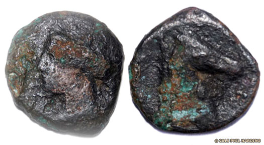 This early third century BC coin's obverse, left, has an image of Tanit, a Punic and Phoenician goddess, while the reverse, right, has a horse's head - horses were a prized asset with a large swathe of Indo-European peoples which included Celts who lived in Britain This early third century BC coin's obverse, left, has an image of Tanit, a Punic and Phoenician goddess, while the reverse, right, has a horse's head - horses were a prized asset with a large swathe of Indo-European peoples which included Celts who lived in Britain |
|
| The coin is dated between 300-264 BC and is most likely to be produced in the Carthaginian colonies on Sardinia. Several similar examples have been found, but only along Britain's coastline, not along a river which is certainly being used for trading purposes during the second millennium AD, a use which would seem to date back at least to this period. While Sardinia is favoured as the coin's place of manufacture, almost any of the Punic empire's colonies could be responsible, including Carthage itself. Clearly trading links exist at this time between the Phoenician colonies and the British Isles, mainly for Britain's tin which is found in large deposits in Devon (of the Dumnonii) and Cornwall (of the Cornovii). Buried in the silt and mud of the Avon's banks for 2,300 years, the coin is generally in poor condition, but its comparative rarity makes it important. |
|
|
| 1st century BC |
Throughout the course of the century there is evidence in the region of a new wave of settlements. Some earlier hill forts appear to fall out of use while others continue to be occupied. Some new settlements are enclosed, replacing older, open settlements, while other settlements remain unaltered. 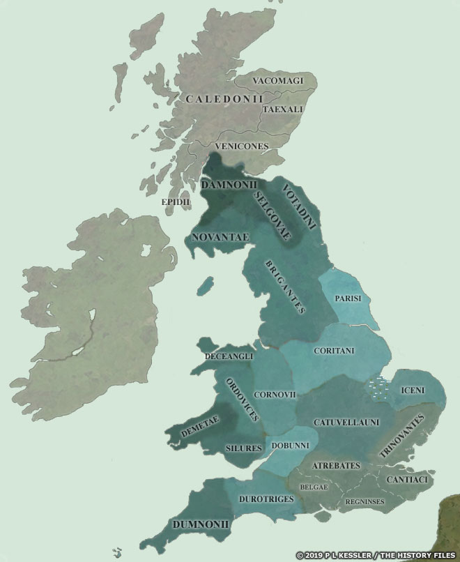 By the end of the first century BC and the start of the first century AD, British politics often came to the attention of Rome, and the borders of the tribal states of the south-east were pretty well known (click or tap on map to view full sized) By the end of the first century BC and the start of the first century AD, British politics often came to the attention of Rome, and the borders of the tribal states of the south-east were pretty well known (click or tap on map to view full sized) |
|
| The pattern of change is uneven and occurs at different times across the century. The building of the grand enclosure settlement of The Bowsings which replaces The Park open settlement occurs at the start of the century, while the Duntisbourne enclosed settlement appears to be created towards the end of the century. The inference is that one of two causes are responsible. Either it is due to the slow in-filtering of a new people, probably Belgic people from the Atrebates or Belgae regions to the east, or non-Belgic Celts who had earlier occupied territory to the east being pushed westwards by the arrival of the aforementioned Atrebates. This raises the question of who originally occupies these regions before the migration or formation of the Dobunni (possibly from two smaller groups - see the introduction for details). The northern Somerset area could be Durotriges or Dumnonii territory, although this is farther north than either tribe is usually thought to bear any influence. Alternatively, the inhabitants could be integrated into the Dobunni. |
|
|
| c.5 BC - AD 7 |
If the Dobunni are indeed vassals of the Atrebates, or a constituent part of the tribe as is sometimes suggested, then it is in this period that they establish their independence. Atrebatean nobles, angered by the pro-Roman stance of Tincommius in direct opposition to the policy of his father and grandfather, form a break-away state of their own. 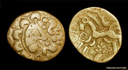 This silver coin, both sides of which are shown, was issued by the Dobunni in the later half of the first century AD - the obverse, left, shows a Celticised head which was typical of many Dobunni silver coins This silver coin, both sides of which are shown, was issued by the Dobunni in the later half of the first century AD - the obverse, left, shows a Celticised head which was typical of many Dobunni silver coins |
|
| They seem either found the tribe of the Dobunni from a previously subjugated people, or they liberate the westernmost Atrebateans (or possibly a combination of both). However, to confuse this view, coinage which is produced by the Dobunni would suggest that they have already made a claim for independence around 30 BC. Coinage exists in this period which is issued from several sites up until the Roman invasion. There is no certainty that all (or any) of the issuers are overall rulers of the Dobunni tribe. Instead, the tribe may regularly enjoy dual kingship, and perhaps even that level of unity may be beyond them. There is evidence of coinage being issued from Bagendon, Ditches, and possibly Salmonsbury during this period. Coins can be found well to the east of Dobunni territory (notably in Northamptonshire), showing strong evidence of intra-Catuvellauni/Dobunnic trade in Britain. Usually the name of rulers under whom coins are issued are abbreviations, perhaps the first part only of their full name. |
|
|
| fl c.10 - c.30 |
Anted- |
Name found on coinage only. Ruler of north & south Dobunni. |
| fl c.30 |
Eisu- |
Son? Name found on coins. Ruler of north & south Dobunni. |
| Inam- / Inara- |
Name found on coinage only. Ruler of north & south Dobunni. |
|
| c.35 - 40 |
The Dobunni appear to fracture into northern and southern divisions, or else they are simply returning to the order which may have existed before possible unification under 'Anted-'. 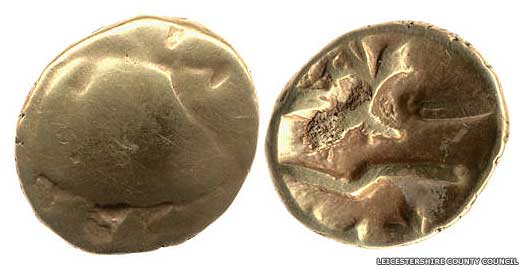 Shown here is a gold Gallo-Belgic quarter stater of the C-type, which can be dated between 80-60 BC, at least a couple of decades before the first of Julius Caesar's expeditions to Britain Shown here is a gold Gallo-Belgic quarter stater of the C-type, which can be dated between 80-60 BC, at least a couple of decades before the first of Julius Caesar's expeditions to Britain |
|
| Catti- |
Name found on coinage only. Ruler of the north. |
|
| Comux- |
Name found on coinage only. Ruler of the south. |
|
| 43 |
By now the tribe has certainly divided in two. The north-eastern part, stretching from the southern side of the Stroud Valley to north-eastern Gloucestershire and western Oxfordshire, is issuing Romanised coinage. In Avon and southern Gloucestershire, the remnant is issuing coins of a native type. There are also two distinctive pottery styles in use which show a north-south split. The suggestion is that the Catuvellauni have gained some sort of control over the north-eastern section of the Dobunni by this stage. This would certainly be in line with their policy of subjugating neighbouring kingdoms. |
|
| fl 43 |
Bodvoc- / Boduoc- / Bodvoccus? |
Ruler of the north-eastern pro-Roman Dobunni. |
| fl 43 |
Corio- |
Ruler of the south-western native Dobunni. |
| 43 |
With the defeat of the Catuvellauni by soon-to-be Roman Governor Aulus Plautius and Emperor Claudius, part of the Dobunni appear to surrender themselves to Plautius by means of envoys. It seems likely that the surrender is made by Bodvoc in defiance of his Catuvellaunian overlords. It cannot be long before the rest of the Dobunni are conquered by the invading Roman imperial forces, and within a year a fort has been established at Corinium (modern Cirencester). (Robert D van Arsdell has Corio dated to 30-15 BC and Bodvoc to 15-10 BC, although they are more normally shown as ruling at the Roman conquest.) 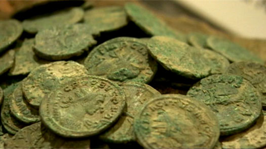 In 2011, two metal detectorists discovered what turned out to be a hoard of Roman artefacts, including 3,800 coins in a clay pot, at Bredon Hill, near Evesham in Worcestershire In 2011, two metal detectorists discovered what turned out to be a hoard of Roman artefacts, including 3,800 coins in a clay pot, at Bredon Hill, near Evesham in Worcestershire |
|
| 43 - 47? |
There is reason to believe that the ex-Catuvellaunian king, and battle leader for the Britons, Caratacus, shelters with the remaining anti-Roman section of the Dobunni. By AD 47 the area is almost certainly included in the occupied or supervised Roman territory so perhaps this forces him to join theSilures. The collective Dobunni remain a Roman client tribe until about AD 97. |
|
| c.49 |
The earliest phase of building in the city of Glevum (Gloucester) is begun. A Roman legionary fort is founded at what is now Kingsholm, close to an Iron Age settlement, overlooking the River Severn (although its course has since changed). The fort probably houses the Twentieth Legion (although a sizable body of opinion prefers the Second Legion). It is located in the (possibly friendlier) northern region of Dobunni territory, commanding the mouth of the River Severn (Sabrina Fluvius) near the Fosse Way, and is probably close to the southern borders of Cornovii territory. |
|
| 61 |
During the Iceni-led revolt in the east, the Silures, Ordovices, Dobunni, and perhaps the Durotriges are probably pinned down by the Roman Second Legion and are unable to join Boudicca. The presence of the legion, under Poenius Postumus, is perhaps due more to fortune than planning. When Roman Governor Suetonius marches back from Wales to reassemble the scattered Roman forces at a location in the Midlands, Postumus refuses to move. Possibly he is influenced by memories of the death of the praefectus castrorum at the hands of the Silures during the governorship of Ostorius. When he hears of Suetonius' victory against Boudicca, Postumus kills himself and his legion joins the governor in the field. 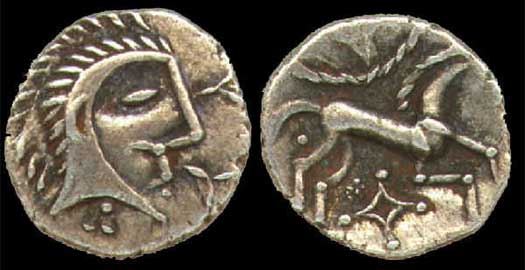 Two sides of a coin issued about AD 61 are shown here, featuring the face of Boudicca on the obverse and a horse on the reverse - horses were valuable commodities amongst the Britons Two sides of a coin issued about AD 61 are shown here, featuring the face of Boudicca on the obverse and a horse on the reverse - horses were valuable commodities amongst the Britons |
|
| c.66 |
The Kingsholm fortress is prone to flooding so a new and larger fortress is built on the higher ground one kilometre to the south, at what becomes Gloucester Cross. It is around this fort that a civilian settlement grows up, forming the early city. Troops are based here in the build up to the invasion of the western tribal regions (modern Wales), with the first strike being against the Silures and Demetae. However, this is apparently delayed by the events of AD 69, the 'Year of Four Emperors'. |
|
| mid-70s |
The Roman fort at Corinium (modern Cirencester) is vacated by legionaries who are probably off to fight the Silures and Demetae. In their place, the Dobunni tribal civitas of Corinium Dobunnorum is founded, perhaps as a replacement for the tribe's possible client status. The Ala Gallorum Indiana auxiliary cavalry unit is (or remains) based here, as evidenced by a tombstone dated to this period on stylistic grounds. Over the next couple of decades the city's street grid is laid out and slowly filled, mostly by stone public buildings, private dwellings and shops. The forum and basilica are the largest in Britain apart from those in Londinium. 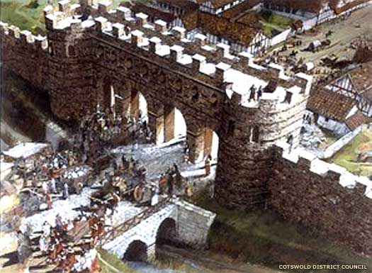 The Roman gates were still in use in Corinium during the mid-fifth century, although just how long they remained looking this impressive is unclear The Roman gates were still in use in Corinium during the mid-fifth century, although just how long they remained looking this impressive is unclear |
|
| 87 |
Following its campaigns in western Britain and then in Caledonia with Agricola, the Twentieth Legion returns to Glevum. The fortress undergoes major changes, with wood being replaced with stone, and new buildings with outer stone walls and timber-framed internal partitions. The general defences are also greatly enhanced, making them amongst the most impressive in Britain to date. |
|
| 96 - 98 |
[ Roman](../KingListsEurope/ItalyRomeEmpire.htm#Adoptive Emperors) Emperor Nerva designates the fort and settlement of Glevum a colonia - Colonia Nervia Glevensium - a self-governing citizen colony which is regulated by a council and four magistrates. This certainly ends whatever client tribal status the Dobunni may have experienced since the conquest. Legionaries settle there as a kind of demobilised reserve, officially retired but liable to be recalled as an auxiliary force should trouble arise in the sometimes fractious western regions. A basilica which houses the administrative body, and a forum which acts as a market place, are also added. Within fifteen years, civilian buildings replace the original fortress. 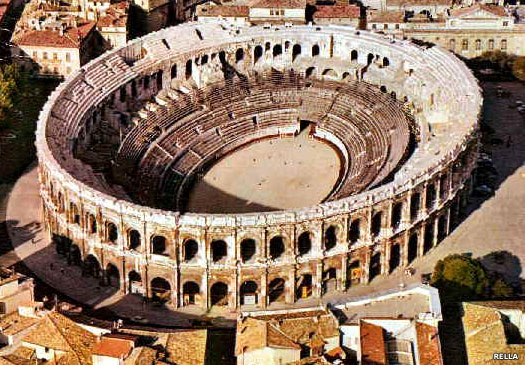 Times were tough in the mid-fifth century, and Britain's resources were not what they had once been, what with barbarians at the door and withdrawal from the fading Roman empire, so Glevum's amphitheatre had to be made defendable (Nemausus (Nimes) amphitheatre is shown here) Times were tough in the mid-fifth century, and Britain's resources were not what they had once been, what with barbarians at the door and withdrawal from the fading Roman empire, so Glevum's amphitheatre had to be made defendable (Nemausus (Nimes) amphitheatre is shown here) |
|
| 2nd century |
The region is blessed with particularly good soil for [ Roman](../KingListsEurope/ItalyRomeEmpire.htm#Adoptive Emperors) farming methods, and there is a significantly high rate of villa-building. The Chedworth and Woodchester villas are amongst their number, both of which possess high quality mosaics. Chedworth is one of the largest villas in the entire country, built facing east (which is unusual), in a sheltered spot overlooking the River Coln. Glevum itself is at its height, and has reached its largest extent. Both it and Corinium are fortified towards the end of the century. |
|
| 165 - 180 |
Plague enters [ Rome](../KingListsEurope/ItalyRomeEmpire.htm#Adoptive Emperors) from the east, brought back by returning legionaries. It quickly spreads throughout the empire and is generally known as the Antonine Plague. When it arrives in Britain it strikes hard. In 2004, archaeologists uncover the remains of ninety-one men, women, and children dumped haphazardly into a mass grave at Glevum. The bones are dated to this period, and are unusual as the Romans are typically very careful about interring their dead. The situation must be fairly dire. 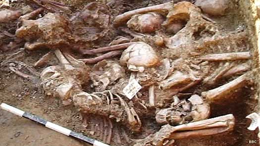 The widespread Antonine Plague which killed these people and resulted in the use of mass graves is thought to have been smallpox The widespread Antonine Plague which killed these people and resulted in the use of mass graves is thought to have been smallpox |
|
| 3rd century |
Archaeologists later unearth a tombstone dating to this century which bears an inscription of someone who has served in the Twentieth Legion. Although the legion itself had supposedly left Glevum by the end of the first century AD, there seems to be a remaining link, perhaps due to Glevum being created a colonia for the legion in AD 97. |
|
| c.300 - 306 |
Around the very start of the fourth century, changes take place at Glevum. The second century wall is replaced by one which is stronger and higher, and with deeper foundations in places. Similar refortification takes place at Caerwent (in the Ewyas district) and Caerleon (in the Cernyw district), as preparations to face a possible threat from the River Severn. The threat is probably presented by a sudden increase in Scotti raids from Ireland, but whether the defences are ever put to the test or not is unknown. Perhaps linked to this threat, and others, in 305-306, the Diocese of the Britains is sub-divided into four provinces. Glevum probably serves as the capital of Britannia Prima, and perhaps even has its own mint. |
|
| c.325 |
Around this date the beautiful Orpheus mosaic is laid down in Woodchester villa, not far from Glevum. The villa remains inhabited until the end of the century. The site is later re-employed as a churchyard. 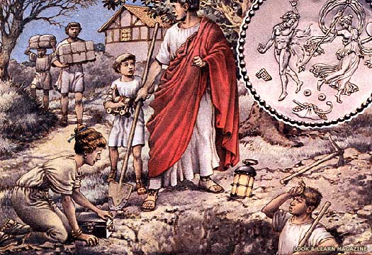 With discord building in the country (and reaching a peak between about 420-450), many Romano-Britons began leaving in a hurry, burying their wealth in the hope that they could return in better times to collect it With discord building in the country (and reaching a peak between about 420-450), many Romano-Britons began leaving in a hurry, burying their wealth in the hope that they could return in better times to collect it |
|
| mid-5th century |
The region which had belonged to the Dobunni, with extra territory to the north and south apparently now included, appears to emerge as a new territory or district in its own right. Caer Gloui is unnamed by any contemporary accounts, but the city which bears that name (modern Gloucester) would be a highly likely candidate to be a regional capital. It, rather than the Dobunni civitas of Corinium Dobunnorum (Corinium, modern Cirencester), has a commanding position which overlooks the Severn, while the stronghold of Amesbury further to the east of Corinium guards that side of the territory, facing towards the encroaching Thames Valley Saxons. |
|
 |
|
|
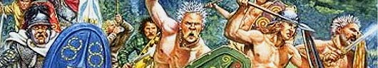
 It was the Romans who coined the name 'Gaul' to describe the Celtic tribes of what is now France and Belgium, quite possibly based on an original form of the word 'Celt' itself (see feature link). When it came to the Celts of Britain, the name of the islands itself was used: Prydein (Latinised as Prettania or Britannia). Its collective people were Britons, although not all of them were Celts, let alone the same 'type' of Celts. Successive waves of immigration had left a vague mix of Bell Beaker folk, Urnfield proto-Celts, Hallstatt and La Tène waves, and Belgae, the latest arrivals. By the first century BC these latter people dominated the south and east of the isles.
  The territory of the Dobunni lay to the west of the Catuvellauni. To the north they were bordered by the Cornovii, to the west by the Silures, to the south by the Durotriges, and to the south-east by the Atrebates and Belgae. Their territory initially comprised northern Wiltshire and southern Gloucestershire, the locations of the earliest coin distributions. The tribe later expanded into western Oxfordshire, northern Gloucestershire, north-eastern Somerset, Avon, parts of Hereford and Worcester, and also South Warwickshire, doubtless absorbing smaller groups whose names have been entirely lost to history (see the map of most of Europe's tribes around the first centuries BC and AD to view this tribe's location in relation to all other Celts). The Dobunni were a non-Belgic people who were organised around an impressive series of hill forts, mostly overlooking the Avon Gorge. However, they did show considerable signs of Belgic influence, which is not surprising given their proximity in the first century BC to several Belgic groups, most notably the Atrebates. It has been suggested that they were little more than a division of the Atrebates, and only gained independence during the reign of the pro-Roman Atrebates ruler, Tincommius, in the late first century BC. If this was the case then the Dobunni were probably an earlier people who had been pushed out of their territory by the arrival of the Atrebates, and subjugated along the way. Generally, Dobunni people lived in small villages and farmed the fertile land. The tribe's name is obscure, but a possible explanation also suggests an identity problem - either two tribes which formed a minor confederation or perhaps two halves of a single tribe. In the Dobunni name, 'do-' may be equivalent to 'du-' and would mean 'two', while 'bun' appears to be proto-Celtic for 'origin'. So, taking a rather large leap, the name may just indicate a tribe which was formed from two smaller ones. Such an origin could explain their apparent divide into two halves in the first century AD. By that time (circa 35 BC) Dobunni borders abutted those of the Atrebates, and the coinage of both tribes seems to be found in parallel. The suggestion is, once again, that the Atrebates were overlords of the Dobunni. However, the Dobunni ejected Romanised Atrebatean coins which appeared from 30/20 BC and began producing their own coins, suggesting a claim of independence. By AD 20/25, the Dobunni also found themselves bordering the powerful Catuvellauni, although they seem to have been on friendly terms with this powerful tribe. Part of their number may have been formed by a speculated 'raven clan' on the northern edges of their territory. This group gave its name to the Roman settlement at Worcester - Branogena - which breaks down into 'raven clan' (discussed in greater detail under the later rulers of this area, the Hwicce). They were also the guardians of the sacred hot wells at Bath, a site of some reverence which people would visit, trying to get as close as possible to the spring at the centre of the marsh which was where the hot water emerged from below the earth, a path to another world. The city of Caer Baddan (Aquae Sulis) would later crystallise around this marsh.