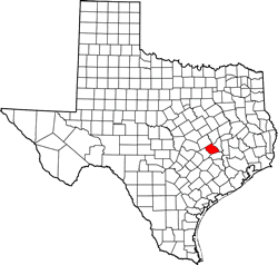
Burleson County Texas. (original) (raw)
Texas | Counties Central Texas South
30� 29' 24" N, 96� 37' 12" W (30.49, -96.62)
Population: 17,642 (2020)
17,187 (2010) 16,470 (2000) 13,625 (1990)
Total area: 677 square miles (1,750 km2)
659 square miles (1,710 km2) land
18 square miles (47 km2) water
| |  |
| ------------------------------------------------------------------------------------------------------------------- |
|
| ------------------------------------------------------------------------------------------------------------------- |
Burleson County History
Historical Marker: (in Courthouse Square, Caldwell)
BURLESON COUNTY
In rich Brazos River basin; had settlers early as 1825. Site in 1830 of Tenoxtitlan, one of 3 forts built by Mexico in Texas, situated above El Camino Real (The King's Highway) crossing on Brazos River. North of the road was Sterling Robertson's Colony; south, the colony of Stephen F. Austin.
In 1840 on the Old Road, Civil Engineer George B. Erath (1813-1891) platted town of Caldwell, named for noted Indian fighter Mathew ("Old Paint") Caldwell. In 1846, Erath introduced in First Legislature of State of Texas a bill creating Burleson County out of land then in Milam and Washington counties. It was named for Gen. Edward Burleson (1793-1851), under whom many local men had fought in the Texas War for Independence and in Indian Wars. Gen. Burleson was a congressman, senator and vice president of the Republic of Texas; also was in first State Senate.
Plantation system prevailed until Civil War (1861-1865). Burleson lost some area when Lee County was created in 1874. In 1880 the Gulf, Colorado & Santa Fe Railway built into county; soon afterward, Houston & Texas Central added more rail mileage.
This is fourth courthouse for county. Economy is based on farming, oil, and miscellaneous products.
(1970)
1936 Texas Centennial Marker:
Formed early as 1744 by Indians under guidance of Spanish missionaries.
In 1830, Ft. Tenoxtitlan, guarding Brazos crossing, San Antonio Road, attracted Anglo-Texans, who lived off wild game in early years.
County created and organized in 1846.
Named for Gen.Edward Burleson (1798-1851), veteran of Battle of San Jacinto; Indian fighter; Republic of Texas vice-president and senator, later a state senator.
County seat, Caldwell (named for Mathew Caldwell, signer of Declaration of Independence).
During the Civil War, furnished troops, cotton and food to Confederate Texas.
(1965)
Burleson County Town List
Cities, Towns & Ghost Towns: History, attractions, landmarks, architecture, monuments, museums, cemeteries, bridges, parks, vintage & contemporary images, area destinations, forum...County Seat - Caldwell
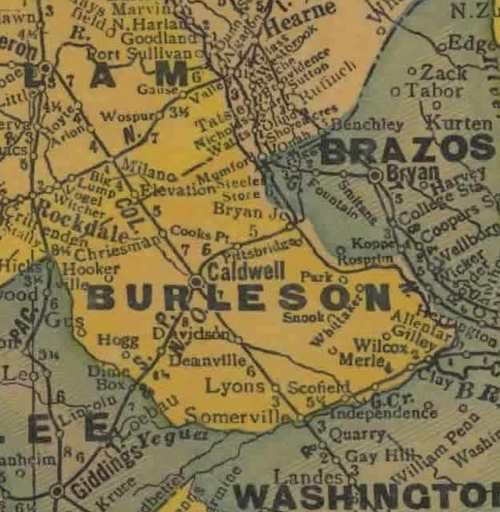
Burleson County Vintage Maps
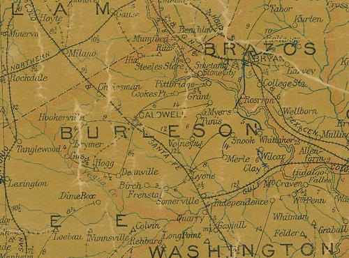
Burleson County 1907 postal map
From Texas state map #2090
Courtesy Texas General Land Office

Burleson County 1920s map
From Texas state map #10749
Courtesy Texas General Land Office
Burleson County 1940s map
From Texas state map #4335
Courtesy Texas General Land Office
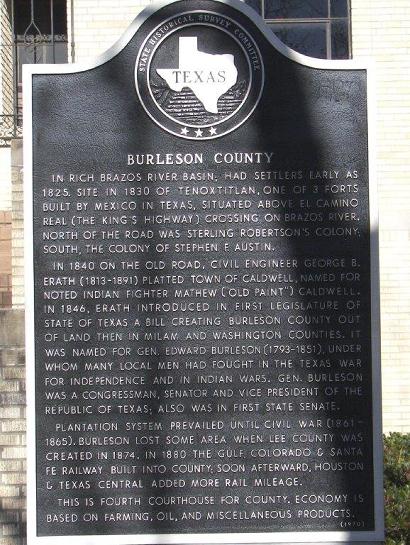
Burleson County Historical Marker
Photo Courtesy Terry Jeanson, February 2010
Texas Escapes, in its purpose to preserve historic, endangered and vanishing Texas, asks that anyone wishing to share their local history, stories, landmarks and recent or vintage photos, please contact us.