Monitoring great ape and elephant abundance at large spatial scales: measuring effectiveness of a conservation landscape - PubMed (original) (raw)
Monitoring great ape and elephant abundance at large spatial scales: measuring effectiveness of a conservation landscape
Emma J Stokes et al. PLoS One. 2010.
Abstract
Protected areas are fundamental to biodiversity conservation, but there is growing recognition of the need to extend beyond protected areas to meet the ecological requirements of species at larger scales. Landscape-scale conservation requires an evaluation of management impact on biodiversity under different land-use strategies; this is challenging and there exist few empirical studies. In a conservation landscape in northern Republic of Congo we demonstrate the application of a large-scale monitoring program designed to evaluate the impact of conservation interventions on three globally threatened species: western gorillas, chimpanzees and forest elephants, under three land-use types: integral protection, commercial logging, and community-based natural resource management. We applied distance-sampling methods to examine species abundance across different land-use types under varying degrees of management and human disturbance. We found no clear trends in abundance between land-use types. However, units with interventions designed to reduce poaching and protect habitats--irrespective of land-use type--harboured all three species at consistently higher abundance than a neighbouring logging concession undergoing no wildlife management. We applied Generalized-Additive Models to evaluate a priori predictions of species response to different landscape processes. Our results indicate that, given adequate protection from poaching, elephants and gorillas can profit from herbaceous vegetation in recently logged forests and maintain access to ecologically important resources located outside of protected areas. However, proximity to the single integrally protected area in the landscape maintained an overriding positive influence on elephant abundance, and logging roads--even subject to anti-poaching controls--were exploited by elephant poachers and had a major negative influence on elephant distribution. Chimpanzees show a clear preference for unlogged or more mature forests and human disturbance had a negative influence on chimpanzee abundance, in spite of anti-poaching interventions. We caution against the pitfalls of missing and confounded co-variables in model-based estimation approaches and highlight the importance of spatial scale in the response of different species to landscape processes. We stress the importance of a stratified design-based approach to monitoring species status in response to conservation interventions and advocate a holistic framework for landscape-scale monitoring that includes smaller-scale targeted research and punctual assessment of threats.
Conflict of interest statement
Competing Interests: The authors have declared that no competing interests exist.
Figures
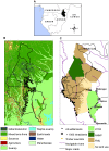
Figure 1. The Ndoki-Likoula Conservation Landscape.
A - Geographic location, B - Main vegetation types, and C - Land-use types and human access features.
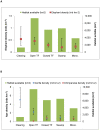
Figure 2. Elephant and ape density by habitat type.
A – Elephant density, B – Great ape density; Clearing = natural forest clearings (bais and yangas) and light gaps, Swamp = swamp forest, Closed/Open TF = Closed-canopy or Open-canopy terra firma forest, Mono. = monodominant Gilbertiodendron forest.
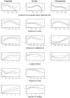
Figure 3. Estimated conditional dependence of sign densities on landscape covariates.
Estimated conditional dependence of Elephant dung density (left column), Gorilla nest density (middle column), and Chimpanzee nest density (right column) on distance to the NNNP boundary (first row), distance to roads (second row), distance to settlements (third row), logging history (fourth row), distance to bais (fifth row), and density of yangas (sixth row). Estimates (solid lines) and confidence intervals (dashed lines), with a rug plot indicating the covariate values of observations (short vertical bars along each x-axis), are shown are shown. Y-axis scale can vary between species for a particular covariate.
Figure 4. Predicted density surfaces from final composite models.
A - Elephant dung density (Distance to bais, density of yangas, distance to roads, distance to NNNP boundary, stratum, Y coordinate), B - Gorilla nest density (Distance to NNNP boundary, stratum, X coordinate), and C - Chimpanzee nest density (Distance to NNNP boundary, distance to roads, stratum, Y coordinate). Density surfaces displayed in ArcGIS 9.2 (ESRI, Redlands, USA) using a Natural Breaks (Jenks) classification set to 10 classes.
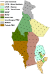
Figure 5. Landscape survey strata and transect placement.
NNNP = Nouabalé-Ndoki National Park, LTCR = Lac Télé Community Reserve, FMU = Forestry Management Unit.
Similar articles
- Survey of gorillas (Gorilla gorilla gorilla) and chimpanzees (Pan troglodytes troglodytes) in Southwestern Cameroon.
Matthews A, Matthews A. Matthews A, et al. Primates. 2004 Jan;45(1):15-24. doi: 10.1007/s10329-003-0058-4. Epub 2003 Oct 29. Primates. 2004. PMID: 14586801 - Spatio-temporal changes in chimpanzee density and abundance in the Greater Mahale Ecosystem, Tanzania.
Carvalho JS, Stewart FA, Marques TA, Bonnin N, Pintea L, Chitayat A, Ingram R, Moore RJ, Piel AK. Carvalho JS, et al. Ecol Appl. 2022 Dec;32(8):e2715. doi: 10.1002/eap.2715. Epub 2022 Sep 30. Ecol Appl. 2022. PMID: 36178009 Free PMC article. - Logging concessions can extend the conservation estate for Central African tropical forests.
Clark CJ, Poulsen JR, Malonga R, Elkan PW Jr. Clark CJ, et al. Conserv Biol. 2009 Oct;23(5):1281-93. doi: 10.1111/j.1523-1739.2009.01243.x. Epub 2009 May 13. Conserv Biol. 2009. PMID: 19453655 - Saving the gorillas (Gorilla g. gorilla) and chimpanzees (Pan t. troglodytes) of the Congo Basin.
Tutin CE. Tutin CE. Reprod Fertil Dev. 2001;13(7-8):469-76. doi: 10.1071/rd01092. Reprod Fertil Dev. 2001. PMID: 11999296 Review. - Producing wood at least cost to biodiversity: integrating Triad and sharing-sparing approaches to inform forest landscape management.
Betts MG, Phalan BT, Wolf C, Baker SC, Messier C, Puettmann KJ, Green R, Harris SH, Edwards DP, Lindenmayer DB, Balmford A. Betts MG, et al. Biol Rev Camb Philos Soc. 2021 Aug;96(4):1301-1317. doi: 10.1111/brv.12703. Epub 2021 Mar 4. Biol Rev Camb Philos Soc. 2021. PMID: 33663020 Review.
Cited by
- Great ape surveys and the implications of long-term monitoring in the Djéké Triangle, Republic of Congo.
Mayoukou W, Morgan D, Strindberg S, McElmurray P, Abedine C, Sanz C. Mayoukou W, et al. Primates. 2024 Nov;65(6):457-468. doi: 10.1007/s10329-024-01157-1. Epub 2024 Oct 21. Primates. 2024. PMID: 39432210 - Chimpanzees employ context-specific behavioral strategies within fission-fusion societies.
Funkhouser JA, Musgrave S, Morgan D, Kialiema SN, Ngoteni D, Brogan S, McElmurray P, Sanz C. Funkhouser JA, et al. Primates. 2024 Nov;65(6):541-555. doi: 10.1007/s10329-024-01165-1. Epub 2024 Oct 19. Primates. 2024. PMID: 39427097 Free PMC article. - FSC-certified forest management benefits large mammals compared to non-FSC.
Zwerts JA, Sterck EHM, Verweij PA, Maisels F, van der Waarde J, Geelen EAM, Tchoumba GB, Donfouet Zebaze HF, van Kuijk M. Zwerts JA, et al. Nature. 2024 Apr;628(8008):563-568. doi: 10.1038/s41586-024-07257-8. Epub 2024 Apr 10. Nature. 2024. PMID: 38600379 Free PMC article. - Population dynamics of western gorillas at Mbeli Bai.
Robbins AM, Manguette ML, Breuer T, Groenenberg M, Parnell RJ, Stephan C, Stokes EJ, Robbins MM. Robbins AM, et al. PLoS One. 2022 Oct 19;17(10):e0275635. doi: 10.1371/journal.pone.0275635. eCollection 2022. PLoS One. 2022. PMID: 36260834 Free PMC article. - Estimating animal abundance at multiple scales by spatially explicit capture-recapture.
Howe EJ, Potter D, Beauclerc KB, Jackson KE, Northrup JM. Howe EJ, et al. Ecol Appl. 2022 Oct;32(7):e2638. doi: 10.1002/eap.2638. Epub 2022 Jun 29. Ecol Appl. 2022. PMID: 35441452 Free PMC article.
References
- DeFries R, Hansen A, Turner BL, Reid R, Liu JG. Land use change around protected areas: Management to balance human needs and ecological function. Ecological Applications. 2007;17:1031–1038. - PubMed
- Rosenzweig M. Win-win ecology: How the Earth's species can survive in the midst of human enterprise. Oxford, UK: Oxford University Press; 2003. 211
- Sanderson EW, Redford KH, Vedder A, Coppollilo PB, Ward SE. A conceptual model for conservation planning based on landscape species requirements. Landscape and Urban Planning. 2002;58:41–56.
- Gardner TA, Caro TIM, Fitzherbert EB, Banda T, Lalbhai P. Conservation Value of Multiple-Use Areas in East Africa. Conservation Biology. 2007;21:1516–1525(1510). - PubMed
- Chazdon RL, Harvey CA, Komar O, Griffith DM, Ferguson BG, et al. Beyond reserves: a research agenda for conserving biodiversity in human-modified tropical landscapes. . Biotropica. 2009;41:142–153.
Publication types
MeSH terms
LinkOut - more resources
Full Text Sources
Research Materials
Miscellaneous


