SECOR (original) (raw)

Home - Search - Browse - Alphabetic Index: 0- 1- 2- 3- 4- 5- 6- 7- 8- 9
A- B- C- D- E- F- G- H- I- J- K- L- M- N- O- P- Q- R- S- T- U- V- W- X- Y- Z
SECOR
American earth geodetic satellite. Geodesy satellite operated by US Army, USA. Launched 1962 - 1965.
AKA: EGRS;SEV. Status: Operational 1962. First Launch: 1962-01-24. Last Launch: 1969-04-14. Number: 13 .
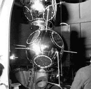
Geodetic SECOR (Sequential Collation of Range) was an all-weather geodetic survey system which was in operational use for over 3 years, establishing a global survey network. It used the successive positions of artificial satellites in space to determine locations on the earth's surface with exactness over long distances.
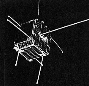
The spacecraft notably was used to precisely determine previously uncertain positions of islands in the Pacific. The system consisted of a satellite and 4 ground stations. 3 at geographical points where the co-ordinates had been surveyed accurately and the fourth at an unknown location. Radio waves were flashed from the ground stations to the satellite and returned. The position of the satellite at any time was fixed by the measured ranges from the 3 known stations. Using these precisely established satellite positions as a base, ranges from the satellite to the unknown station were used to compute the position of the unknown station. Geodetic SECOR allows continents and islands to be brought within the same geodetic global grid. Each ground station was entirely portable and contained 3 units: a radio frequency shelter, a data handling shelter and a storage shelter. Lighter weight, solid-state equipment was developed to replace the initial units. The satellite had a mass of 18 kg and contained a transponder, a telemetry system to monitor temperature and operating voltages, and a power unit comprised of solar panels and batteries. Prime Contractor was Cubic Corporation. Experiments with SECOR, together with the Navy's Timation, provided the technical basis for the GPS Navstar system.
More at: SECOR.
Subtopics
Family: Earth, Earth geodetic sat, Medium earth orbit. Country: USA. Launch Vehicles: Atlas, Thor, Delta, Scout, Thor Ablestar, Atlas SLV-3 Agena D, Thor Agena D, Thor SLV-2A Agena D, Thor SLV-2 Agena D, Scout B, Thorad SLV-2G Agena D, Thor Burner 2, Thor Burner. Launch Sites: Wallops Island, Cape Canaveral, Vandenberg, Cape Canaveral LC17B, Vandenberg SLC2E, Vandenberg SLC10W, Vandenberg SLC1E, Vandenberg SLC2W, Vandenberg SLC3E, Wallops Island LA3A, Vandenberg SLC4E. Agency: USN, Cubic, US Army. Bibliography: 2, 278, 279, 405, 6, 6860, 13080.
Photo Gallery
 |
SECOR 1Credit: Manufacturer Image |
|---|
 |
SecorCredit: Manufacturer Image |
|---|
1962 January 24 - . 09:30 GMT - . Launch Site: Cape Canaveral. Launch Complex: Cape Canaveral LC17B. LV Family: Thor. Launch Vehicle: Thor Ablestar. FAILURE: Failure.
1964 January 11 - . 20:07 GMT - . Launch Site: Vandenberg. Launch Complex: Vandenberg SLC1E. LV Family: Thor. Launch Vehicle: Thor SLV-2A Agena D.
- SECOR 1 - . Payload: EGRS 1. Mass: 18 kg (39 lb). Nation: USA. Agency: US Army. Class: Earth. Type: Geodetic satellite. Spacecraft: SECOR. USAF Sat Cat: 729 . COSPAR: 1964-001C. Apogee: 922 km (572 mi). Perigee: 904 km (561 mi). Inclination: 69.90 deg. Period: 103.30 min. Located Pacific islands. Space craft engaged in investigation of spaceflight techniques and technology (US Cat A). .
1965 March 9 - . 18:29 GMT - . Launch Site: Vandenberg. Launch Complex: Vandenberg SLC2W. LV Family: Thor. Launch Vehicle: Thor SLV-2 Agena D.
- SECOR 3 - . Payload: EGRS 3. Mass: 18 kg (39 lb). Nation: USA. Agency: USA ACE. Class: Earth. Type: Geodetic satellite. Spacecraft: SECOR. USAF Sat Cat: 1208 . COSPAR: 1965-016E. Apogee: 925 km (574 mi). Perigee: 898 km (557 mi). Inclination: 70.10 deg. Period: 103.20 min. Space craft engaged in investigation of spaceflight techniques and technology (US Cat A). .
1965 March 11 - . 13:39 GMT - . Launch Site: Vandenberg. Launch Complex: Vandenberg SLC2E. LV Family: Thor. Launch Vehicle: Thor Ablestar.
- SECOR 2 - . Payload: EGRS 2. Mass: 18 kg (39 lb). Nation: USA. Agency: USA ACE. Class: Earth. Type: Geodetic satellite. Spacecraft: SECOR. Decay Date: 1968-02-26 . USAF Sat Cat: 1250 . COSPAR: 1965-017B. Apogee: 1,014 km (630 mi). Perigee: 296 km (183 mi). Inclination: 90.00 deg. Period: 97.90 min. Failed. Space craft engaged in investigation of spaceflight techniques and technology (US Cat A). .
1965 April 3 - . 21:24 GMT - . Launch Site: Vandenberg. Launch Complex: Vandenberg SLC4E. LV Family: Atlas. Launch Vehicle: Atlas SLV-3 Agena D.
- SECOR 4 - . Payload: EGRS 4. Mass: 40 kg (88 lb). Nation: USA. Agency: USA ACE. Class: Earth. Type: Geodetic satellite. Spacecraft: SECOR. USAF Sat Cat: 1315 . COSPAR: 1965-027B. Apogee: 1,316 km (817 mi). Perigee: 1,267 km (787 mi). Inclination: 90.20 deg. Period: 111.40 min. Failed. Space craft engaged in investigation of spaceflight techniques and technology (US Cat A)..
1965 August 10 - . 17:54 GMT - . Launch Site: Wallops Island. Launch Complex: Wallops Island LA3A. LV Family: Scout. Launch Vehicle: Scout B.
- SECOR 5 (EGRS 5) - . Payload: SEV / FW4S. Mass: 24 kg (52 lb). Nation: USA. Agency: NASA Langley. Class: Earth. Type: Geodetic satellite. Spacecraft: SECOR. USAF Sat Cat: 1506 . COSPAR: 1965-063A. Apogee: 2,419 km (1,503 mi). Perigee: 1,134 km (704 mi). Inclination: 69.20 deg. Period: 122.20 min. Spacecraft engaged in research and exploration of the upper atmosphere or outer space (US Cat B). .
- Secor 5 - . Payload: Secor 5. Nation: USA. Agency: US Army. Spacecraft: SECOR. USAF Sat Cat: 1502 . COSPAR: 1965-063B. Apogee: 2,424 km (1,506 mi). Perigee: 1,136 km (705 mi). Inclination: 69.20 deg. Period: 122.22 min.
1966 June 9 - . 20:10 GMT - . Launch Site: Vandenberg. Launch Complex: Vandenberg SLC3E. LV Family: Atlas. Launch Vehicle: Atlas SLV-3 Agena D.
- SECOR 6 - . Payload: EGRS 6. Mass: 17 kg (37 lb). Nation: USA. Agency: USA ACE. Class: Earth. Type: Geodetic satellite. Spacecraft: SECOR. Decay Date: 1967-07-06 . USAF Sat Cat: 2205 . COSPAR: 1966-051B. Apogee: 3,646 km (2,265 mi). Perigee: 168 km (104 mi). Inclination: 90.00 deg. Period: 125.00 min. Space craft engaged in investigation of spaceflight techniques and technology (US Cat A). .
1966 August 19 - . 19:26 GMT - . Launch Site: Vandenberg. Launch Complex: Vandenberg SLC3E. LV Family: Atlas. Launch Vehicle: Atlas SLV-3 Agena D.
- SECOR 7 - . Payload: EGRS 7. Mass: 17 kg (37 lb). Nation: USA. Agency: USA ACE. Class: Earth. Type: Geodetic satellite. Spacecraft: SECOR. USAF Sat Cat: 2411 . COSPAR: 1966-077B. Apogee: 3,700 km (2,200 mi). Perigee: 3,671 km (2,281 mi). Inclination: 89.70 deg. Period: 167.50 min. Space craft engaged in investigation of spaceflight techniques and technology (US Cat A). .
1966 October 5 - . 22:00 GMT - . Launch Site: Vandenberg. Launch Complex: Vandenberg SLC3E. LV Family: Atlas. Launch Vehicle: Atlas SLV-3 Agena D.
- SECOR 8 - . Payload: EGRS 8. Mass: 17 kg (37 lb). Nation: USA. Agency: USA ACE. Class: Earth. Type: Geodetic satellite. Spacecraft: SECOR. USAF Sat Cat: 2520 . COSPAR: 1966-089B. Apogee: 3,707 km (2,303 mi). Perigee: 3,674 km (2,282 mi). Inclination: 90.00 deg. Period: 167.60 min. Space craft engaged in investigation of spaceflight techniques and technology (US Cat A). .
1967 June 29 - . 21:01 GMT - . Launch Site: Vandenberg. Launch Complex: Vandenberg SLC10W. LV Family: Thor. Launch Vehicle: Thor Burner 2.
- SECOR 9 - . Payload: EGRS 9. Mass: 20 kg (44 lb). Nation: USA. Agency: USA ACE. Class: Earth. Type: Geodetic satellite. Spacecraft: SECOR. USAF Sat Cat: 2861 . COSPAR: 1967-065A. Apogee: 3,940 km (2,440 mi). Perigee: 3,803 km (2,363 mi). Inclination: 90.20 deg. Period: 172.10 min.
Two scientific satellites, an Army Sequential Collation of Range (SECOR) and a Navy Aurora I, were launched from Vandenberg aboard a Thor/Burner II. This was the first flight in the Department of Defense's Space Experiments Support Program (SESP), a tri-service program that allowed qualified government-sponsored space experimenters to fly payloads on Air Force boosters. Space Systems Division managed the program and provided boosters, payload integration, and launch services. Defense's Space Experiments Support Program (SESP), a tri-service program that allowed qualified government-sponsored space experimenters to fly payloads on Air Force boosters. Space Systems Division managed the program and provided boosters, payload integration, and launch services. Location survey. Space craft engaged in investigation of spaceflight techniques and technology (US Cat A).
1968 May 18 - . 08:23 GMT - . Launch Site: Vandenberg. Launch Complex: Vandenberg SLC2E. LV Family: Thor. Launch Vehicle: Thorad SLV-2G Agena D. FAILURE: Failure.
- EGRS 10 - . Payload: Secor 10. Nation: USA. Agency: USAF. Spacecraft: Secor. Army-sponsored Sequential Collocation of Range (SECOR) satellite..
1969 April 14 - . 07:54 GMT - . Launch Site: Vandenberg. Launch Complex: Vandenberg SLC2E. LV Family: Thor. Launch Vehicle: Thorad SLV-2G Agena D.
- SECOR 13 - . Payload: EGRS 13. Mass: 20 kg (44 lb). Nation: USA. Agency: USA ACE. Class: Earth. Type: Geodetic satellite. Spacecraft: SECOR. USAF Sat Cat: 3891 . COSPAR: 1969-037B. Apogee: 1,129 km (701 mi). Perigee: 1,070 km (660 mi). Inclination: 100.30 deg. Period: 107.30 min. Spacecraft engaged in practical applications and uses of space technology such as weather or communication (US Cat C). .
Home - Search - Browse - Alphabetic Index: 0- 1- 2- 3- 4- 5- 6- 7- 8- 9
A- B- C- D- E- F- G- H- I- J- K- L- M- N- O- P- Q- R- S- T- U- V- W- X- Y- Z
© 1997-2019 Mark Wade - Contact
© / Conditions for Use
