Topex/Poseidon (original) (raw)

Home - Search - Browse - Alphabetic Index: 0- 1- 2- 3- 4- 5- 6- 7- 8- 9
A- B- C- D- E- F- G- H- I- J- K- L- M- N- O- P- Q- R- S- T- U- V- W- X- Y- Z
Topex/Poseidon

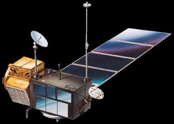
Topex/Poseidon
Credit: Manufacturer Image
American earth sea satellite. TOPEX/Poseidon was a co-operative mission between the United States and France designed to provide high-accuracy global sea level measurements. Earth Observing satellite built by Fairchild for NASA, CNES, France. Launched 1992. Used the MMS bus.
AKA: Poseidon. Status: Operational 1992. First Launch: 1992-08-10. Last Launch: 1992-08-10. Number: 1 . Gross mass: 2,402 kg (5,295 lb).
Data from TOPEX/Poseidon was used to map ocean circulation patterns, help understand how the oceans interact with the atmosphere, and improve our ability to predict the global climate.
NASA provided the satellite bus, five instruments, and was responsible for spacecraft operations. CNES furnished two of the spacecraft's instruments and the mission's Ariane launch vehicle. During its first 3 years on orbit, the satellite measured sea heights to within 4 cm. The spacecraft was based on Fairchild's Multi-Mission Spacecraft bus and was 3-axis stabilized (nadir pointing) via reaction wheels and torque rods. Attitude determination was via Earth sensors, Sun sensors, star cameras, an inertial reference unit, and magnetometers. A single solar array with 1-axis articulation provided 3400W (BOL) and recharged 3 x 50 A-hr batteries. A 1.2 m high gain antenna allowed communications via TDRSS. A hydrazine propellant system allowed orbit maintenance. The GPS antenna was mounted on a deployed boom to minimize multipath noise. The payload included:
- Dual frequency altimeter (C- and Ku-Band) measured the height of the satellite above the sea.
- TOPEX Microwave Radiometer (TMR) measured the water vapor along the path viewed by the altimeter to correct the altimeter data for pulse delay due to water vapor.
- Single-frequency Solid-State Altimeter (SSALT) operates at 13.65 GHz (Ku-Band) to measure the height of the satellite above the sea, wind speed, and wave height.
- The Laser Reflector Array (LRA) was used with ground-based lasers to track the satellite and to calibrate and verify altimeter measurements.
- A GPS receiver was used to provide precise orbit ephemeris data.
- DORIS (Doppler Orbitography and Radio positioning Integrated by Satellite) was also used for precise orbit determination, as well as to receive signals from ground stations for satellite tracking, make gravity field measurements, and provide ionospheric correction data for SSALT.
More at: Topex/Poseidon.
Family: Earth, Earth seasat, Medium earth orbit. Country: USA. Launch Vehicles: Ariane, Ariane 42P. Launch Sites: Kourou, Kourou ELA2. Agency: JPL, NASA, CNES, Fairchild. Bibliography: 2, 279, 4179, 4180, 4181, 4182, 6, 6990, 13286.
1992 August 10 - . 23:08 GMT - . Launch Site: Kourou. Launch Complex: Kourou ELA2. LV Family: Ariane. Launch Vehicle: Ariane 42P.
- Topex/Poseidon - . Mass: 2,402 kg (5,295 lb). Nation: France. Agency: CNES, JPL. Class: Earth. Type: Sea satellite. Spacecraft Bus: MMS. Spacecraft: Topex/Poseidon. USAF Sat Cat: 22076 . COSPAR: 1992-052A. Apogee: 1,344 km (835 mi). Perigee: 1,331 km (827 mi). Inclination: 66.00 deg. Period: 112.40 min. Ocean sensing, mapping. Spacecraft engaged in research and exploration of the upper atmosphere or outer space (US Cat B)..
Home - Search - Browse - Alphabetic Index: 0- 1- 2- 3- 4- 5- 6- 7- 8- 9
A- B- C- D- E- F- G- H- I- J- K- L- M- N- O- P- Q- R- S- T- U- V- W- X- Y- Z
© 1997-2019 Mark Wade - Contact
© / Conditions for Use